Showing 573 items
matching land surveyed
-
 City of Moorabbin Historical Society (Operating the Box Cottage Museum)
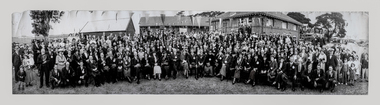
Photograph, B/W East Bentleigh SS No.2083 1925, 1925
The Common School No. 213 East Brighton 1864 - 1878 replaced the original St Stephen's Church of England School in Tucker Road. 1878-1908 the School was known as Education Department State School No. 2083 Brighton East. 1908 - 1936 the School changed it's name to Bentleigh and then from 1936 - 1993 was known as East Bentleigh. 1993 the school was closed due to low enrollments and the building was demolished and land sold . Charles J Coates, the father of Pam Thomas, attended this school.A school photograph of one of the original schools in the Bentleigh area showing a gathering of adults and children who had connection with this school either as teachers, pupils, parents or neighbours in 1925.A Black & White panoramic photograph of a group of adults and children in front of the classrooms of the East Bentleigh SS No. 2083 in 1925on back : handwritten 1925education, st stephens anglican school east brighton, education department state schools, state school number 2083, coates charles j, thomas pam, tucker road bentleigh, henry dendy special survey brighton 1841,market gardeners, dairy farmers, poultry farmers, early settlers, pioneers, tuck family bentleigh, moorabbin shire, moorabbin roads board, city of moorabbin, bent thomas, -
 City of Moorabbin Historical Society (Operating the Box Cottage Museum)
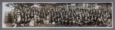
Photograph - B/W Bentleigh SS No.2083 1930, c1930
The Common School No. 213 East Brighton 1864 - 1878 replaced the original St Stephen's Church of England School in Tucker Road. 1878-1908 the School was known as Education Department State School No. 2083 Brighton East. 1908 - 1936 the School changed it's name to Bentleigh and then from 1936 - 1993 was known as East Bentleigh. 1993 the school was closed due to low enrolments and the building was demolished and land sold. Eric Hutchinson, the uncle of Les Hutchinson attended this school. A school photograph of one of the original schools in the Bentleigh area showing a gathering of adults and children who had connection with this school either as teachers, pupils, parents or neighbours in 1930.A Photograph , black & white panoramic showing group of adults and children in front of Bentleigh State School No. 2083 c1930 (Reprint) moorabbin, bentleigh, education department state schools, st stephens anglican school east brighton, hutchinson les, hutchinson eric, market gardeners, early settlers, pioneers, henry dendyspecial survey brighton 1841, east bentleigh state school no. 2083, coates charles j, bent thomas -
 City of Moorabbin Historical Society (Operating the Box Cottage Museum)
Tool - Blacksmith Anvil
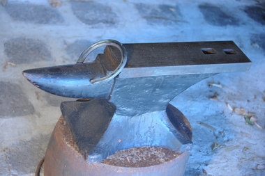
This anvil is typical of the type used by Blacksmiths in Moorabbin Shire c1850 - 20thC Blacksmith were needed to make machinery, tools, farm and household equipment, wheels and wagons, horseshoes and saddle irons.This anvil is an example of the type used by blacksmiths in Moorabbin Shire 1840- 20thC as early settlers developed the land. built homes, shops and schoolsSolid steel single horn shaped block used by a Blacksmith to make tools, horseshoes, kitchenware, farm equipment, wagon wheelsmarket gardeners, early settlers, moorabbin shire, dendy special survey 1841, bentleigh, moorabbin, cheltenham, tools, anvils, steel, horses, wagons, washing pots, cooking pots, blacksmiths, county of bourke -
 City of Moorabbin Historical Society (Operating the Box Cottage Museum)
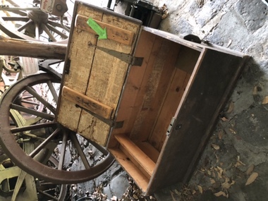
Functional object - Travel Trunk, c 1851 wood, brass lock and hinges and Guernsey Newspaper 1851, c1851
This wood traveling trunk was used by the LePage family when emigrating from Guernsey , Channel Isles, to Melbourne on SS Caliope 1852. Nicholas LePage , a tailor, and wife Elizabeth arrived in Melbourne in 1852 with their son Frank Thomas and daughter Elizabeth. Joshua Holloway released land in his 'Two Acre Village' in Cheltenham 1851. Nicholas bought a LOT for 10pounds and began a market garden that was managed by successive generations. The LePage family became involved with the Methodist Church , local friendly societies, sporting clubs and civic councils that endured. 'The LePages became one of the best known Moorabbin market gardening families, with a tradition of service to communal and civic affairs that is unmatched' John Cribbin, ' Moorabbin ,Pictorial History 1862-1994.' (City of Kingston)A handmade wood trunk with brass lock and hinges and Guernsey ( Channel Isles) Newspaper lining 1851Top of lid; White Stencil BETSEY LEPAGE / PASSENGER TO MELBOURNE Lining of box; Guernsey Newspaper 1851 henry dendy's special survey 1842, moorabbin shire, moorabbin roads board, dendy henry, were jb, holloway josiah, brighton, bentleigh, cheltenham, pioneers, market gardeners, early settlers, methodist church, two acre village cheltenham, charman stephen, bent thomas, daphne cottage, sons of temperance friendly society, mayors moorabbin council, lepage nicholas, lepage frank thomas, lepage everest, lepage frank wilbur, cheltenham co-operative society, cheltenham cream and butter factory -
 City of Moorabbin Historical Society (Operating the Box Cottage Museum)
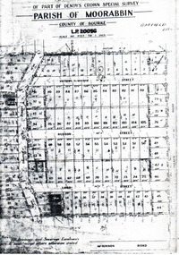
Flyer - Garfield Estate, Ormond
At the end of World War One, there was a renewed interest in residential land and a number of estates opened up in the Municipality of Moorabbin.Example of the progress of the Municipality of MoorabbinPhotocopy of the plan of the Garfield Estate, OrmondPart f Dendy's Crown Special Survey - parish of Moorabbin - County of Bourke - Garfield Estatedraper street, lord street, hudson street, blackshaw street, tucker road, ormond, mckinnon, real estate -
 Bendigo Historical Society Inc.
Document - H.A. & S.R. WILKINSON COLLECTION: CONTRACT OF SALE
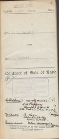
Contract of sale of land dated 24th March 1954 between Mr. E.T. Fennell (seller) and Mr. L. Riddell (buyer) for that land situate Jackass Flat being described in right to occupy residence area right No. 0251, together with weatherboard dwelling and all sundry. Price 525 pounds. Also attached receipt no.81247, dated 13 April, 1954 from the department of Crown Lands and Survey, also a letter to Messrs T.M. Williams , Watson, James, Solicitors, Bull Street Bendigo dated 26 March, 1954 signed by Mr.. Fennell instructing to pay from the proceeds of sale of property, Grassy Flat, the sum of 400 pounds to Messrs H.A. & S.R. Wilkinson of 182 Mitchell Street, Bendigo as deposit on purchase of Mr. A.L. Stuckenschmidt's property Raglan Street, White Hills.organization, business, h.a. & s.r wilkinson real estate -
 Bendigo Historical Society Inc.
Document - H.A & S.R. WILKINSON COLLECTION: CONTRACT OF SALE
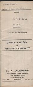
Conditions of sale by private sale dated 10th April, 1940 between W.V.O. Earl (seller) and C.M.F. Skilbeck (buyer) for land situate No.148 Booth Street, Bendigo, being the land described in right to occupy residence area No.4501. Also all the vendor's right, title and interest in that piece of land adjoining the above mentioned land described in permissive occupancy title no. W.52845, together with 5-roomed weatherboard dwelling and all sundry. Also bath, copper and troughs. Price 175 pounds. Attached 5 receipt issued by Department of Lands and Survey plus 2 receipt from City of Bendigo for rates. Vendor's copy.organization, business, h.a. & s.r wilkinson real estate -
 Bendigo Historical Society Inc.
Document - H.A. & S.R. WILKINSON COLLECTION: CONDITION OF SALE
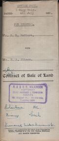
Contract of sale of land dated 4th July, 1952 between Mr. D. R. McClure (seller) and Mr.. H. A. Pitson for land described in right to occupy residence area No. 9508, together with all buildings and erection thereon, also all sundries inside and outside the building. Price 60 pounds. Also attached various receipt from Department of lands and survey, copy of the right to occupy land issued in 1942, letter from the City of Bendigo dated in 1951 drawing attention to unpaid rates on the property.organization, business, h.a. & s.r wilkinson real estate -
 Bendigo Historical Society Inc.
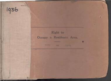
Book - RIGHT TO OCCUPY RESIDENCE AREA COLLECTION: REGISTER 1936
COLLECTION OF RIGHT TO OCCUPY A RESIDENCE AREA -LAND (RESIDENCE AREAS ) Act 1935 / thick cardboard book -cloth and string binding / written on front in texter '1936' / numbers 5001 to 5100 / inside - stubs of documents showing Granted to , of, period, Date of Right , Description of Land , Allotment, Section, City, Town , Borough , Township of , Parish of , Authorised Person . Rubber stamps show The interest of this Right has been transferred to /one stub shows Department of Lands and Survey note on Bendigo Historical Society Catalogue Sheet dated 12.6.2008 All buts completed and original application forms removed. Note -forms were originally in triplicate on one page with serrations for removal of two parts; butts remain .Residence areas in Central Goldfields.Bendigo City Council - Acquisition 1990organization, government, official -
 Bendigo Historical Society Inc.
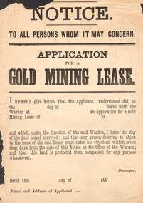
Document - NOTICE: APPLICATION FOR GOLD MINING LEASE
1880's Aged Paper ' Notice To All Persons Whom It May concern - Application for gold Mining Lease stating 'I hereby give notice , that the applicant undernamed did, on …leave with the Warden at… an application for a Gold Mining Lease of …of …and which, under the direction of the said Warden , I have the day of the date hereof surveyed ; and that any person desiring to object to the issue of the said Lease must enter his objection within seven clear days from the data of this Notice at the office the Warden ; and that this land is protected from occupation for any purpose whatsoever . Dated …188, by authority: John Ferres , Government printer, MelbourneJohn Ferres , Government printer , Melbournegold, mining, lease, ' notice to all persons whom it may concern - application for gold mining lease / john ferres , government printer , melbourne -
 Bendigo Historical Society Inc.
Document - BUSINESS LICENSE PETITION
Handwritten and typed copies of a Business License Petition. Petition is about storekeepers, etc. who have built their businesses on Crown Land. The petitioners hoped that the land upon which they have erected their premises may be surveyed and put up for public auction and that the premises on the land are valued and allowed for.document, names of bendigo pioneers, business license petition, business license petition, i hendry, major general macarthur -
 Bendigo Historical Society Inc.
Document - VICTORIA HILL - RECOMMENDATION - MINING PROJECT
Two (a & b) typed copy of a recommendation for mining project, accepted Nov. 1967. Recommendation for Central Nell Gwynne area, now a public purposes reserve for preservation as a permanent reminder of the gold mining era. Victoria Hill Area mentioned for it's geographical and historical significance. The New Chum Hill area rich in historical and mining. Notes on development of the Central Nell Gwynne, Victoria Hill and New or Old Chum Hill areas.mine, gold, victoria hill, victoria hill, recommendation - mining project, central nell gwynne, jack barker, victoria hill area, big 180, victoria quartz, new chum hill (old chum hill), p. m. g. repeater station, mine's department, land's department, lansell, fortuna, a h q survey regiment, lazarus mine, b c v 8 television studio -
 Bendigo Historical Society Inc.
Photograph - BENDIGO POST OFFICE 1854
Photo: copy of photo of first Bendigo Post Office and Survey Office, located corner of Mitchell and Pall Mall. Building constructed by John Pyke, land purchased for 1800 pounds in first land sales. Source of information: Dr. Ralph Birrell. This reproduction is the property of the National Library of Australia, and is not for reproduction in any form apart from for research.bendigo, buildings, post office and survey office -
 Bendigo Historical Society Inc.
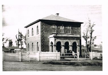
Photograph - WES HARRY COLLECTION: LAND OFFICE VIEW STREET
Black and white photo copy: image shows Survey office in View Street, known as Dudley House. Two storey brick building with verandah. Three arches in front portico facing street front. Picket fence on front of street, small buildings at rear.Batchelderplace, building, dudley house, bendigo, sandhurst, survey office, larritt, view street -
Bendigo Historical Society Inc.
Book - MINING REPORTS - MINES DEPARTMENT CAN WE HELP YOU?
Small, 40 page paper booklet issued by E. Condon, Secretary of Mines, under the authority of The Hon. J. C. M. Balfour, MLA, Minister of Mines. The booklet was printed Melbourne, Victoria 1969. Topics include: Assistance to Mining, Commencing Mining Operations, Concessions to Mining Industry, Miners Rights and Claims, Mining Leases and Licences, Examination Boards, Gold Buying and Selling, Air Conditions in Mines, Cyanide Plant, State Crushing Batteries, Extractive Industries, Petroleum (On Land), Petroleum (Offshore), Pipelines, Explosives, Inflammable Liquids, Gas Meter Examination and Liquified Pertoleum Gas.book, mining reports, mines department can we help you?, e condon, the hon j c m balfour, geological survey of victoria, mines department laboratories, explosives and gas examining branch, minister for mines, depot & core laboratory -
 Bendigo Historical Society Inc.
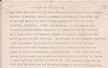
Document - NORMAN OLIVER COLLECTION: SPEECH NOTES FROM YEARS 1949-1971
The Norman Oliver collection. Norman Oliver was three times Mayor of Bendigo - 1950-51, 1964-65, 1970-71. a) Seventeen pages of typed notes for a speech. Topics include : The story of the taxi cab, Your library, Regional library development, Land reclamation, Traffic control, A point about parking, Social (visit to Fortuna by Major General Brown Director of Ordnance survey, British Army), The historical society. Undated, but next to other notes marked 1951. b) a donation letter headed 'The Mayor Speaks' states: Herein are the texts of addresses given by the Mayor Cr N.J Oliver over Radio Station 3BO, together with other talks given by him. They were given to Alex H Stone by Mr Oliver on his leaving Bendigo. They are now handed by him to Bendigo Branch - Royal Historical Society of Victoria, as they are worthy of preservation. 26-3-1982 signed Alex H Stone.bendigo, council, speech notes, norman joseph oliver , councillor norman oliver, sometime mayor of bendigo. radio station 3bo 'the mayor speaks'. bendigo centenary 1951. -
 Bendigo Historical Society Inc.
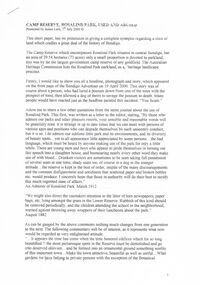
Document - PRESENTATION TO BHS 7TH JULY 2000: ''CAMP RESERVE'', 7th July 2000
Presentation by James Lerk to BHS 7th July 2000: ''Camp Reserve -Rosalind Park, used and abused''. First line: ''This short paper has no pretension in giving a complete synopsis regarding a slice of land which cradles a great deal of the history of Bendigo''. References to Commissioner Gilbert; Bank of Victoria; Bendigo Bank; powder magazine; post office; Survey Office; Court of Petty Sessions; Police Barracks; Supreme Court; Gaol; Temperance Society; Robert Strickland residence; tenements on Reserve; Mac's Track; Orderly Room; Cascades; Corporate High School; Temperance Fire Brigade; Masonic Hall; Central School Camp Hill; Fernery; ''The Willows''; Conservatory; Parade Ground; Sandhurst Club; Police Station; Grandstand in Upper Reserve; High School; Soldiers Memorial Insitutute; Lookout (poppet head - Garden Gully United); Advance Bendigo and North League crèche; Sound Shell; Olympic Swimming Pool. Two printed copies.James Lerk.bendigo, streetscape, camp reserve, rosalind park, bendigo creek -
 Bendigo Historical Society Inc.
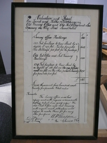
Document - VALUATION AND REPORT ON LAND AND PUBLIC BUILDINGS, 1888
Framed document, valuation and report on land and public buildings vis old survey office and Post Office and sub Treasury in View Street Sandhurst, hand written in black ink and signed N P Simpson Feby 22nd 1888. Under glass in a thin black wooden frame.document, certificate, public buildings -
 Bendigo Historical Society Inc.
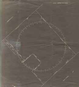
Document - SURVEY PLAN OF HARGREAVES & HOPETOWN STREETS
Undated survey plan by William Bockli, Consulting Engineer 422-428 Collins St Melbourne showing land between Hargreaves St and Hopetoun St Bendigo, stamped 'Hanro Aust Bendigo Knitting Mill, PTY,LTD., Job 37, drawing No 8. Scale . 30 feet to an inch. Unknown donorbendigo, industry, hanro knitting mill -
Port Melbourne Historical & Preservation Society
Plan - Proposed land sub-division, west of railway, Sandridge, 19 Nov 1866
1866 plan of proposed sub-division of land at Sandridge, west of railway. Includes manure depot.J. Noone (Photolithographer, Dept. of Lands and Survey) J. Hardy (Assistant Surveyor)town planning, town planning - proposals shelved, j noone, j hardy -
 Women's Art Register
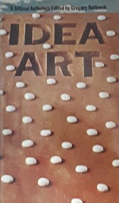
Book - Anthology, Gregory Battcock, Idea Art, 1973
A survey of theories, practices and documents that outlines the origins of US and European Idea Art of the 1960s and 1970s.non-fictionA survey of theories, practices and documents that outlines the origins of US and European Idea Art of the 1960s and 1970s.idea art, land art, conceptual art, lucy lippard, dore ashton, jonathan benthall, cheryl bernstein, jack burnhan, joseph kosuth, ursula meyer, john perreault, arthur rose, harold rosenberg, seth siegelaub, sol le witt, lawrence weiner, daniel buren, mel bochner, robert hughes -
Port Melbourne Historical & Preservation Society
Letter - Office of Lands & Survey re permission to build a boat on Sandridge Beach, Secretary for Lands, 22 Jun 1876
Photo\copies of letter and small map from Office of Lands & Survey, 22 June 1876. Re permission to lease land to build a boat on Sandridge Beach. Original letter sent to J.C. Lowrie of Stokes Street. Various copies stapled together.local government - borough of sandridge, j c lowrie, sandridge beach -
Port Melbourne Historical & Preservation Society
Letter - Lands & Survey Office re land for football ground, 19 Apr 1880
... Lands & Survey Office re land for football ground...Letter from Lands & Survey Office regarding land... & Survey Office regarding land for football ground, 1880 Letter ...Letter from Lands & Survey Office regarding land for football ground, 1880sport - australian rules football, sport - recreational grounds, peter gallienne grut, port melbourne football club, pmfc -
Port Melbourne Historical & Preservation Society
Letter - Lands & Survey Office re permission to use land for football ground, 13 May 1880
Letter from Lands & Survey Office granting permission for use of land as per tracing sheet for football ground, 1880sport - australian rules football, sport - recreational grounds, peter gallienne grut, port melbourne football club, pmfc -
Port Melbourne Historical & Preservation Society
Plan - Football Ground, Department of Survey & Lands, 13 May 1880
Plan for Football Ground on land being granted by Department of Survey & Lands, 1880sport - australian rules football, sport - recreational grounds, j kitchen & sons pty ltd, port melbourne football club, pmfc -
Port Melbourne Historical & Preservation Society
Letter - Department of Lands and Survey granting land for temporary reserve, 18 Mar 1860
... Department of Lands and Survey granting land for temporary...Handwritten letter from Dept of Lands and Survey granting... Dept of Lands and Survey granting Crown land for temporary ...Handwritten letter from Dept of Lands and Survey granting Crown land for temporary reserve as site for abattoirs 18 March 1861local government - borough of sandridge, industry - noxious, department of lands and surveys, clement hodgkinson -
Bendigo Historical Society Inc.
Document - DVD OF 1856 PETITION AND INDEX, 1856
DVD/CD. Transcription of names from 1856 Petition from persons at Sandhurst occupying Lands under Business Licenses praying that if the intention of Govt is carried into effect, their lands may be surveyed for sale and the improvements valued.bendigo, law, land improvements -
 Bendigo Historical Society Inc.
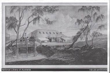
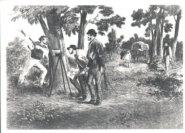
Photograph - WES HARRY COLLECTION: SURVEY PARTY, 1854
Photograph of a drawing depicting a survey party in 1854. In the left foreground there are Two men, one is looking through a theodolite and another is blazing a mark on to a tree with an axe. Two other men are dragging a chain measure. In the background there is a boy standing by a horse and cart. The whole group is in a bush land setting.organization, lands and survey, original survey, surveying, theodilite, chain -
 Bendigo Historical Society Inc.
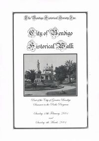
Book - CITY OF BENDIGO HISTORICAL WALK BOOK, 2001
Photocopy mock up of original booklet of The Bendigo Historical Society Inc. 'City of Bendigo Historical Walk' containing photographs of historic buildings to be seen on the walk. Front cover Queen Victorian Gardens, Town hall, Mechanics Institute/School Of Mines and Industry, H. M. Prison Bendigo, Camp Hill Police Barracks, Sandhurst Corporate High School, Central State School No. 1976, The Cascades, District Lands Office (Dudley House), Masonic Temple and Hall, Sandhurst Volunteer Rifle Brigade Orderly Room, Bank of Victoria, Henry Jackson's Store View Point,Alexandra Fountain, Beehive Store/Mining Exchange, Colonial Bank. Hustlers Royal Reserve NO. 2/R.S.L. Memorial Hall, Post Office 3rd 4th and final, Bendigo Law Courts, Shamrock Hotel 2nd and another view. Important Bendigo Dates; 1851, April gold discovered at Golden Square by Margaret Kennedy,1851 Approx. 200,000Troy oz. of gold found in Bendigo, 1852 475,857 Troy oz. Gold for the year, 1853 November 31st Bendigo Hospital admits first patient,1853 December 9th Bendigo Advertiser first issue printed, 1854 First Land Sales and streets are surveyed and named for the first time, 1854 Census of Bendigo showed 15,480 residents plus 4,000 Chinese, 1855 Sandhurst Municipal District formed, 1861 Sandhurst Proclaimed a Town. 1862 Railway to Melbourne opened, 1867 Visit by His Royal Highness the Duke of Edinburgh, 1871 July 21st Sandhurst proclaimed a City, 1881 Population of Sandhurst 14,577 residents, 1882 First telephone communications introduced, 1890 Electric trams (battery) commenced running, 1891 May 18th City of Sandhurst changes its name to City of Bendigo.book, bendigo, buildings, historic -
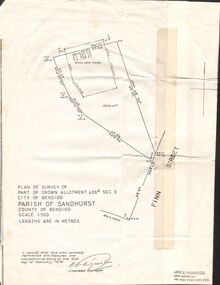 Bendigo Historical Society Inc.
Document - CROWN ALLOTMENT 406A (PLAN) JOSS HOUSE
Plan of Survey of part of Crown Allotment 406A Sec E. City of Bendigo. Parish of Sandhurst. County of Bendigo. Scale 1:500. (Copy of Original). As at 21 February 1979. This survey shows the location of the Joss House and the portion of land where it is located.plan, bendigo, joss house, crown allotment 406a (plan), joss house