Showing 1069 items
matching lilydale
-
 Eltham District Historical Society Inc
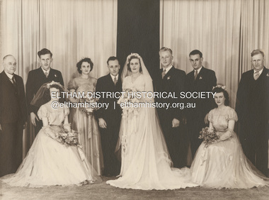
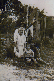
Photograph, Michael Doolay, Wedding of Leslie Ernest Shillinglaw and Alva Elizabeth Thomas, 1949
Standing L-R: Ernest Samuel Shillinglaw, John Thomas, Min Bergin, Leslie Ernest Shillinglaw, Alva Shillinglaw (Nee Thomas), Doug Way, Don Richards, Cecil Thomas Seated L-R: Frances Thomas, Melva Richards (nee Shillinglaw) ENGAGEMENTS The Engagement is announced of Alva Elizabeth, daughter of Mr. and Mrs. C. J. Thomas, Mt. Eliza, to Leslie Ernest, only son of Mr. and Mrs. E. S. Shillinglaw, Healesville. Family Notices (1948, November 13). Healesville Guardian (Lilydale, Vic. : 1942 - 1954), p. 2. Retrieved December 4, 2022, from http://nla.gov.au/nla.news-article60678669marg ball collection, 1949, alva elizabeth shillinglaw (nee thomas), cecil thomas, don richards, doug way, ernest samuel shillinglaw (1888-1958), frances thomas, john thomas, leslie ernest shillinglaw, melva lucy richards (nee shillinglaw), melva lucy shillinglaw, min bergin, wedding -
 Uniting Church Archives - Synod of Victoria
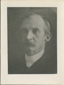
Photograph, Undated c.1913
Joseph Ringland Anderson was born in Killylea, Ulster, Ireland in March 1854. At the age of 18 he joined the Presbyterian Church at Killylea by profession of faith. He studied at Queen's College, Galway, and graduated M.A. He then studied Theology at the General Assembly's Theological Hall, Belfast. In 1881 he decided to emigrate to Australia, and completed his theological education at Ormond College, Melbourne. He was ordained in 1882 and inducted into the Presbyterian Church at Penshurst, Victoria. While at Penshurst he married Annie Love Elder. He was called to Lilydale in 1893, to Beechworth in 1902, to North Carlton in 1907 and 1913, was inducted into the Kew Presbyterian Church. Retired and demitted 1926. Died 12 August 1941B & W head and shoulders photograph of the Rev. Joseph Ringland Anderson, M.A. printed on buff cardRev. J.R. Anderson, M.A. 1913 - 1926joseph ringland anderson, ulster, ormond college, kew, presbyterian, minister -
 Melbourne Tram Museum
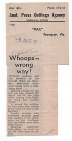
Newspaper, Mail Footscray, "Whoops - wrong way", 5/08/1981 12:00:00 AM
Newspaper cutting from the Mail Footscray about W2 227 derailing while turning from Ballarat Road into Gordon St and heading towards the Power Hotel on the Monday (3/8/1981) afternoon. Titled "Whoops - wrong way" See also Reg item 1639 for its subsequent sale to a Lilydale property, though this may not be correct - a check with the tramcar card shows that it was withdrawn and sold during July 1981 and that Z3 227 did not enter service until 1984. Cuttings has the Aust. Press Cuttings Agency source sheet pasted to the top right hand corner along with the paper name and date stamp.Has in pencil at top of cutting "MT/Ballarat Trams"trams, tramways, accidents, mmtb, footscray, ballarat rd, gordon st, w2 class, tram 227 -
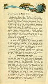
![Scene at Healesville / [by] Nicholas Caire, circa 1876](/media/collectors/550653872162f11fb04854aa/items/577b4f7bd0cdd10948cab12f/item-media/577b4fe9d0cdd10948caef25/item-fit-380x285.jpg) Kew Historical Society Inc
Kew Historical Society IncPhotograph, Anglo-Australasian Photographic Company, Scene at Healesville, c. 1876
Nicholas Caire was born on Guernsey in the Channel Islands in 1837. He arrived in Adelaide with his parents in about 1860. In 1867, following photographic journeys in Gippsland, he opened a studio in Adelaide. From 1870 to 1876 he lived and worked in Talbot in Central Victoria. In 1876 he purchased T. F. Chuck's studios in the Royal Arcade Melbourne. In 1885, following the introduction of dry plate photography, he began a series of landscape series, which were commercially successful. As a photographer, he travelled extensively through Victoria, photographing places few of his contemporaries had previously seen. He died in 1918. Reference: Jack Cato, 'Caire, Nicholas John (1837–1918)', Australian Dictionary of Biography.An original, rare photograph from the series 'Views of Victoria: General Series' by the photographer, Nicholas Caire (1837-1918). The series of 60 photographs that comprise the series was issued c. 1876 and reinforced a neo-Romantic view of the Australian landscape to which a growing nationalist movement would respond. Nicholas Caire was active as a photographer in Australia from 1858 until his death in 1918. His vision of the Australian bush and pioneer life had a counterpart in the works of Henry Lawson and other nationalist poets, authors and painters.Views of Victoria (General Series) No.24 / ‘Scene at Healesville’ / Albumen silver photograph mounted on cardOn Reverse: ‘After leaving the villages of Lilydale and S. Hubert the scenery commences to assume a very wild and romantic appearance. The country becomes exceedingly undulatory, and the belts of densely packed scrub, present altogether a very different appearance from the more settled and cultivated districts. Our illustration is taken from one of the many creeks which surround the rising township of Healesville.’nicholas caire (1837-1918), australia - landscape photography -
 Ringwood and District Historical Society
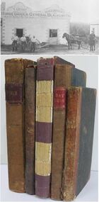
Book - Business Records, Collection of 5 Day-books and Ledgers kept by Thomas Grant, Blacksmith, Ringwood, Victoria
GRANT, Thomas (From Short Notes on Ringwood - RDHS) Born 1854, died 1933, aged 79 years. Thomas Grant, born in Burwood, Victoria, came to Ringwood in 1876. On land purchased from Mr. D. Gostick in Whitehorse Road, in the vicinity of the present Drive In Arcade, he built a blacksmith's and coach building shop. In 1880, he married Mary Ann French, of Mulgrave. There were four children, Andrew, Mary, (died in infancy) Thomas, and Margaret. Miss Margaret Grant is a well known resident of Mullum Road. With the opening of the station in 1882, activities in the growing district tended to congregate in its vicinity, and, in 1883, Mr. Grant moved his “smith" to the corner of Adelaide Street. At the same time, he planted out an orchard on his land which ran from Ringwood Street, to Warrandyte Road, and north as far as Mullum Greek. Eventually, about 1910, he sold his business to the Reed Brothers, and retired to the comparatively lighter life of orchardist and market gardener. In 1909, he sold 8 acres of his land to the Lilydale Council. This land, situated in Ringwood Street, behind the Town Hall, is known as the Ringwood Reserve. Mr. & Mrs. Grant were foundation members of the Methodist Church. He was appointed a Trustee in 1879, and served until his death 54 years later. He was an enthusiastic member of many societies, and he held public office in civic affairs. His interests included the Progress Association, Cricket Club, and the Agricultural Society, at whose annual show, he was a regular exhibitor. He served as a Councillor in the Lilydale Shire, repres¬enting Ringwood, from 1889 to 1894, and was a Justice of the Peace. 26278a Ledger belonging to First Blacksmith in Ringwood 1880s. Dark green cover with leather spine and corners. Dark coloured edges on pages. 542 pages, 320 used. 26278b Day book belonging to Thomas Grant, Blacksmith, Ringwood used 1929. Brown covered book with leather spine. First 95 pages torn out. Only two pages of remaining 76 used. 26278c Ledger with alphabetical index - Thomas Grant, Blacksmith, Ringwood - 1888. Green covered book with red spine and corners. Dark coloured edges on pages. 275 pages. Some unused. 26278d T. Grant Blacksmith Day Book. Green covered day book of T. Grant, Blacksmith and General Smithy, Ringwood 1883 . Red square on spine with Day book written on it. Day Book in ink hand written on front spine. 26278e Day book belonging to Thomas Grant, Blacksmith, Ringwood - 1879-1881. Green cover with brown spine and edges. Gold lettering on spine saying Day Book Pages all used. 26278f Collection of receipts, some blotting paper, some pages from the Journal of Architecture, a short story, and drawing with description of an Albert Sociable carriage. -
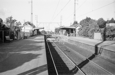 Eltham District Historical Society Inc
Photograph, George Coop, Mont Albert Railway Station, c.1956
Churchill Street shops just visible on right of image. The grass embankment visible in the distance on the left of the track is from where another view looking down the track beside Churchill Street was taken. Shows the original building on the northern platform of the Mont Albert station. The railway line was extended out to Lilydale with work commencing in 1882. Mont Albert station opened in 1890. It is presumed that this building was demolished when the third line was constructed in 1971. At the same time the nearby Surrey Hills original station buildings were demolished. George noted that he had donated a black and white print copy of this image some years earlier to the Surrey Hills Historical Society - see SHP2018/21/6 https://victoriancollections.net.au/items/5d6a450a21ea670e188d05c9Digital TIFF file Scan of Kopdak 620 black and white negative transparencygeorge coop collection, churchill street, mont albert railway station -
 Eltham District Historical Society Inc
Photograph, George Coop, Elgin Street railway overpass, Hawthorn, c.1962, 1962
Looking southwest towards the Burwood Road overpass on the Camberwell line. GC took this photograph as he liked the laciness of the bridge supports. It is GC's assumption that shortly after the Granville disaster in NSW (18 January 1977) where a train derailment wiped out the bridge supports causing the bridge to collapse and crush the train, that bridges of this kind were replaced to have a single arch bridge structure and that the opportunity was taken when the third line went out the Camberwell, Box Hill, Lilydale lines. There are now three lines there. Back then there used to be the old line coming from Hawthorn to Kew across Barkers Road behind Xavier College and into what is now the VicRoads building in the heart of Kew and a single carriage train like the shuttle service between Eltham and Hurstbridge operated on this line.Digital TIFF file Scan of 35mm Ilford FP3 black and white transparency458m, burwood road, camberwell line, elgin road, hawthorn, lilydale line, overpass, red rattler, tait train, -
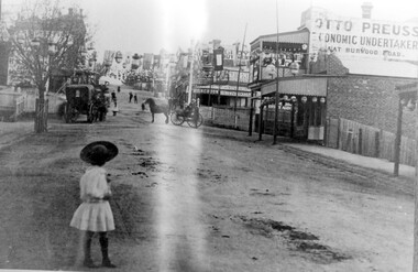 Surrey Hills Historical Society Collection
Photograph, Empire Day in Surrey Hills circa 1912
Empire Day celebrations were held from 1908-1912. Prior to the opening of the railway in 1893 the only public transport to Surrey Hills was the Melbourne-Lilydale horse coach which travelled to Surrey Hills down Victoria Street and Mont Albert Road. The fare to Union Road was 9 pence. Photo 16-4a was the number given to the original print provided by the State Savings Bank. Ken Hall made a negative from it, and the reprint of this was given the number 1459. This number was chosen as the catalogue number to avoid confusion with SHP4a. Photo provided by Surrey Hills branch of State Savings Bank of Victoria in 1978 for launch of Surrey Hills Neighbourhood Centre and was one of the first photos in the collection. The inscriptions on the reverse may indicate it was used in the Surrey Hills Neighbourhood News.Black and white photo of Union Road looking south towards Canterbury Road. The street is decorated with lanterns and the Union Jack and other flags for Empire Day celebrations. There is a young girl in the foreground looking towards the railway crossing where there is a horse drawn cab and a horse drawn cart. Business signage includes that for a butcher, Sneddon's Real Estate and Otto Preuss, Economic Undertaker.On rear: "113% "; "Enlarge to 172 mm" and 2 arrows, all in blue biro.union road, empire day celebrations, horse drawn vehicles, undertaker, sneddon real estate, businesses, union road shops, otto preuss -
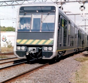 Surrey Hills Historical Society Collection
Photograph, Double deck (4D) train through Surrey Hills
These were introduced in 1992 on the Lilydale-Belgrave lines only (not on the Alamein or Waverley lines). They were a prototype. Many station platforms had to have the coping reduced or replaced in order to provide clearance. The trial was a failure because, while the carriages carried more passengers, they also took longer to load and unload, negating any benefits from carriage of extra passengers. They were used as off-peak trains only on the Surrey Hills line. The 4D carriages were based on the Tangara carriage being built by A Goninan & Co for CityRail in Sydney, however they were similar only in terms of interior and exterior bodywork. They were manufactured from stainless steel and were fitted with air-conditioning, tinted windows, and inter-car doors, allowing passengers to access all carriages of the train. A coloured photograph of a double decker train - silver in colour with a yellow and green strip across the front of the train.Double Decker train / through Surrey Hillssurrey hills, trains, tangarra carriage, a goninan & co, 4d train, belgrave lilydale lines -
 The Beechworth Burke Museum
Geological specimen - Slice Dendrites on Sandstone, Unknown
Dendrites are deposits of black minerals, typically manganese oxides that precipitated from water seeping through fractures in fine-grain rocks like a sandstone or limestone. Dendrites are much less regular than plant fossils and lacks vein structures. The manganese cryztallizes through the process called 'supercooling'. Some samples of dendrites occur in volcanic rocks in the Lilydale district, east of Melbourne. Sandstones are made of tiny sand grains that may have been deposited in the sea and later formed together. Most sandstones are made of quartz which are chemically-resistant minerals. This particular specimen was donated by Alfred Selwyn in 1868 as part of the Geological Survey of Victoria. It is connected to the original 1875 catalogue on Geological Specimen with number 189 'Quartz Crystals_Quartz Crystals (two are polished)'Dendrites on sandstones This specimen is an important contribution to the geological history of Victoria, as well as its links to the 1868 Geological Survey of Victoria. This specimen is part of larger collection of significant geological specimens in the Burke Museum that was collected from around the world between 1868-1880. A large percentage of these specimens were collection as part of the Geological Survey of Victoria 1852-1974. The Geological Survey of Victoria was an organisation founded in response to the Victorian gold rush to explore the geological and mineral resources and to record a detailed map of the state. It was headed by British geologist, Alfred Richard Cecil Selwyn (1824-1902), who was responsible for issuing over 60 geological maps during his 17 years as director. These maps were all hand-drawn and coloured and became the benchmark for accuracy for geological mapping. Collecting geological specimens was an important part of mapping and understanding the scientific makeup of the earth. Many of these specimens were sent to research and collecting organisations across Australia, including the Burke Museum, to educate and encourage further study. A hand-sized slice of light brown sandstone with dendrites formed from crystallized manganese oxide.Existing label: Not sure what / 'Slica dondrites' / means. / Sample is sandstone and original label / identifies it as from / the Grampians near Stawell. / C. Willman / 15/4/21 Other label: [illegible] / stone [ illegible] / from Grampians Stawell / 1894 /geological specimen, geology, geology collection, burke museum, beechworth, dendrites, sandstones, quartz, lilydale district, geological survey of victoria, grampians, victoria rocks, minerals, rocks, manganese oxides, alfred selwyn -
 Southern Sherbrooke Historical Society Inc.
Information folder - Local Government Amalgamations 1986, 1985 & 1986
Folder containing information pertaining to the Local Government amalgamations in Victoria in 1986. Contents: -copy of "Local Government Act 1958, appointment of a division of the local government commission and referral of proposals to the division", 8 pages and 6 explanatory maps -memo, dated 21 November 1985 from K. E. Matson, General Manager, Shire of Sherbrooke, to all councillors, re. local government commission and municipal restructure, 12 pages including map -letter, Warwick Heine, CEO, Shire of Lilydale to K. E. Matson, General Manager, Shire of Sherbrooke, dated 16 April 1986, re. local government restructure (2 copies) -booklet, "The Restructure of Local Government in Victoria: Options Paper Eastern Melbourne Segment", Local Government Commission June 1986, 24 pages -article "Residents to fight land deal", Knox-Sherbrooke News, 17 June1986, re. proposed annexation of part of Lysterfield by Berwick Council -article "Knox and Sherbooke align for the future", The Trader, 30 April 1986, re. alignment of common boundary -article "Boundary changes 'just a joke'", by Cheryl Critchley, Knox-Sherbrooke News, 6 May 1986 , re. Knox-Sherbrooke boundary alignment -article "Border clash worsens", by Peter Janky, Mountain District Free Press, 7 May 1986, re. Sherbrooke-Lilydale boundary changes -article "Ranges future is still clouded", The Free Press 30 April 1986, re. proposal to form a shire covering Dandenong Ranges -article "Sherbrooke wins first battle in restructuring", by Peter Janky, Free Press, 30 April 1986, re. ceding of forest areas by Knox to Sherbrooke.shire of sherbrooke, shire of lilydale, knox city council, berwick shire council -
 Monbulk Historical Society
Thomas and Lillian Cavey with sons Tom and George
Thomas William Cavey was born in 1871, he was the youngest of his family and the only child that was born in Australia. He was first employed at the lime kilns in Geelong, before moving to Queensland for 4 years where he worked as a Boundary Rider. Thomas returned to the Lilydale area to be the driver of a buggy and pair for David Mitchell of David Mitchell Quarry in Lilydale. He selected land in Seamer Road in Monbulk in about 1898, but was working for the railways in Melbourne at the time and would come up to Monbulk at weekends to clear and cultivate the land. He met Lillian Eager, probably through relatives of hers, the Wingates, who lived in Monbulk. He and LIllian were married in 1910. They bought a 22 acre property in what is now called Cavey Road. They had two sons Thomas Charles, born in 1918 and George William Born in 1923. Initially the property in Cavey Road was farmed for vegetables, fruit and berries. The land used for this was over a creek on steep land away from the house. Once the produce was harvested it was taken by flying fox, back across the creek to where it could be prepared for sale. It was then taken to the Emerald and Belgrave markets each week. Later 10 cows were purchased, and the main income from the property was the dairy which produced approximately 25 quarts of milk a day, they produced Cream and Butter and together with the milk they were delivered fresh daily in the horse and cart. Deliveries were made to Monbulk, The Patch and to the canvas town at Silvan Dam, where the workers building the Silvan Dam lived. Thomas William Cavey died in 1959 aged 89. Lillian Blanche Cavey died in 1949 aged 68. -
 Ringwood and District Historical Society
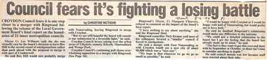
Newspaper, Scrapbook Clipping, Library Collection, Ringwood, Victoria, `
``Newspaper clipping from "The Mail" 8 -6- 94 P1 - Council fear's it's fighting a losing battle by Christine McTigheCroydon Council fears it is one step closer to a merger with Ringwood following the release of the Local Government Board's final report on the boundaries of 21 inner metropolitan councils. Croydon Mayor Cr Les Wilmott favors taking over the urban areas of Lilydale, namely Kilsyth, Mooroolbark and Wonga Park. The council fears that the Board has made up its mind to a merger between Croydon and Ringwood, which the councils don't want.` -
![Entrance to Fernshawe / [by] Nicholas Caire, circa 1876](/media/collectors/550653872162f11fb04854aa/items/577b462bd0cdd10948c53643/item-media/577b46c2d0cdd10948c58d0c/item-fit-380x285.jpg) Kew Historical Society Inc
Kew Historical Society IncPhotograph, Anglo-Australasian Photographic Company, Entrance to Fernshawe, c. 1876
Nicholas Caire was born on Guernsey in the Channel Islands in 1837. He arrived in Adelaide with his parents in about 1860. In 1867, following photographic journeys in Gippsland, he opened a studio in Adelaide. From 1870 to 1876 he lived and worked in Talbot in Central Victoria. In 1876 he purchased T. F. Chuck's studios in the Royal Arcade Melbourne. In 1885, following the introduction of dry plate photography, he began a series of landscape series, which were commercially successful. As a photographer, he travelled extensively through Victoria, photographing places few of his contemporaries had previously seen. He died in 1918. Reference: Jack Cato, 'Caire, Nicholas John (1837–1918)', Australian Dictionary of Biography, National Centre of Biography.An original, rare photograph from the series 'Views of Victoria: General Series' by the photographer, Nicholas Caire (1837-1918). The series of 60 photographs that comprise the series was issued c. 1876 and reinforced a neo-Romantic view of the Australian landscape to which a growing nationalist movement would respond. Nicholas Caire was active as a photographer in Australia from 1858 until his death in 1918. His vision of the Australian bush and pioneer life had a counterpart in the works of Henry Lawson and other nationalist poets, authors and painters.Albumen silver photograph mounted on boardPrinted inscription on reverse: A fifty-mile drive from Melbourne, via Lilydale, will bring the traveller to the township of Fernshawe. On nearing the entrance to the town, the scenery becomes most enchanting. In the distance can be seen the summit of Mount Munday. The ridge of trees in the middleground forms part of the foot of the Black Spur. The building in the foreground is the residence of the only Government Official, who represents the various titles of Post-master, State School Teacher, Registrar, &c.landscape photography - australia - 19th century, nicholas caire -
 Ringwood and District Historical Society
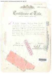
Document, Certificate of Title - Crown Sections 12, 15, and Part of Section 20 (later including Warranwood, Vic.), Parish of Warrandyte, County of Evelyn - 11 June, 1898
A4 copies of Landata Victoria Historical Search documents - Vol 2687 Fol 537231.The Mutual Assurance Society of Victoria Limited of 406 Collins Street Melbourne, County of Bourke, is now the proprietor of an Estate in Fee-simple - 1,640 acres 3 roods 31 perches or thereabouts, being Crown Sections 12, 15, and part of Crown Section 20, Parish of Warrandyte, County of Evelyn. TRANSFER - 13th March, 1899 - 17ac 3rds 5per to The President Councellors and Ratepayers of the Shire of Lilydale (Part of Crown Section 20). -
 Ringwood and District Historical Society
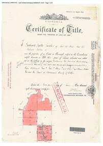
Document, Certificate of Title - Crown Allotments 4A, 4B, 11A, 11B, and Crown Sections 5 and 6 (later including Wonga Park, Vic.), Parish of Warrandyte, County of Evelyn - 17 June, 1895
A4 copies of Landata Victoria Historical Search documents - Vol 2574 Fol 514725.Frederick Walter Purches of Ascot Vale, Wholesale Butcher, is now the proprietor of an Estate in Fee-simple - 2,291 acres 3 roods 24 perches or thereabouts, being Crown Allotments 4A, 4B, 11A, 11B, and Crown Sections 5 and 6, Parish of Warrandyte, County of Evelyn. Transfers include The Mutual Assurance Society of Victoria Limited, 15th August, 1896, The President Councellors and Ratepayers of the Shire of Lilydale, 13th March, 1899. -
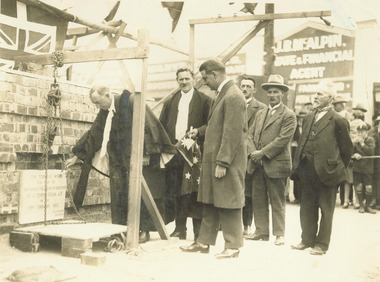 Ringwood and District Historical Society
Photograph, Mayor A.T. Miles laying foundation stone of the Ringwood town hall, 1927
Black and white photograph (2 copies, 1 mounted on cardboard backing).Typed below photograph: "Mayor A.T. Miles laying foundation stone of the town hall - Corner of Main Street and Melbourne Street 19.2.1927." Written on rear of cardboard backing: "Mayor A.T. Miles laying stone of town hall, C/r Main St. & Melbourne St. Sept 1927. Town Clerk A.F.B. Long, Architect A.C. Leith, Builder J. Roberts, Brick contractor J. Hayden from Lilydale." -
 Orbost & District Historical Society
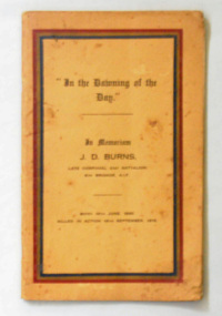
book, Brown, Prior & Co, In the Dawning of the Day, 1916
Many of the poems contained in this book were written by Burns while at school and first appeared in "The Scotch Collegian" which he edited in 1913-1914. Four of his editorials are included. Prose and verse tributes by former schoolmates and fellow soldiers are included, as well as an essay on Burns by the headmaster of Scotch College, W.S. Littlejohn. James Drummond Burns was born in Geelong in 1895. James was the first of eight children born to Hugh and Mary and while he was born at Geelong the family had moved to Bairnsdale by 1905. As Methodist minister, Hugh had accepted the posting to Bairnsdale where the family stayed till about 1913. He died in Gallipoli on September 18 1915. James was a student when he enlisted on 2 February 1915 at Lilydale, Victoria. He served in the 21st Battalion with the rank of Corporal. His Regimental Number was 805. (ref. Scotch College World War I Commemorative Website) This book is a tribute to a WW1 soldier and contains contemporary writing which can be used in research. A thin 32 pp paper back book with a brown cover. On the cover is the title, "In the Dawning of the Day: in Memoriam, J. D. Burns", in black print inside a rectangular red/gold/black line frame. -
 Mont De Lancey
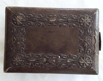
Photograph, Stewart & Co, Photo Album, c 1800's
The original owner was Louis Kolling.An antique thick rectangular photograph album made of dark tan leather with an elaborate embossed floral and leaf design on the front and back covers. The brass clasp on the side is in working order but is broken. It contains 24 thick double sided cardboard pages which have sepia family photographs inserted. There are several missing photographs. Each picture has the name of the photographic studio printed at the bottom of it. Some photos have names written beneath them in blue writing. Each page has beautiful hand painted coloured flowers and leaves decorating them. At the front is a highly coloured decorative floral title page with the word - Album. On the back of this page is a blank Index with 100 spaces to write the names of those in the photographs. The whole album as quite worn and damaged with several inscriptions.'On the front right side endpaper is handwritten on the textured page in blue ink 'Mrs Kelling, a present from Mrs Bond'. Painted ornately in colourful paints is 'Martha Bond' There is a strip of paper included on this page handwritten in blue biro 'Donated posthumously by Louis Kolling, a first cousin and neighbour of Edmund L. Burgi'. On the back endpaper handwriitten in grey pencil ''Via Lilydale' On the last page of photographs on the opposite page is handwritten in blue ink 'Mrs Kolling Clifton Hill.' which is underlined.photographs, albums, photograph albums, photographic accessories -
 Port Fairy Historical Society Museum and Archives
Award - Athletic Sash, c. 1954
These sashes were awarded to Frank Pevitt a successful runner in the late 1940's and early 1950's. The year 1954 was when Frank finally came into his own. In March he came second in the mile and two miles in Bendigo and then, a week later, won the Lilydale Gift and the Eighty five pound prize. In April he won the two-mile Grampian Stakes at Stawell. In a large field of 81 starters, he won by five yards. Following this, he came a creditable third in the Bendigo Guineas. To cap off the year, at the end of December he won the Port Fairy Mile from John Barmby, 'effortlessly' according to the Argus newspaper. In 1955 Frank won the mile at the Orford Sports Club meeting and then decided to retire from running More information on Frank's career as a runner can be found in 'Icons of Port Fairy' a book published by the Port Fairy Historical Society which contains information on objects and people 'Iconic' in our area.These sashes are representative of local resident Frank Pevitt's athletics career and the part that sport played in the early 20th century2 sashes royal blue, a. Port Fairy mile, metal badge with metal badge of wreath & athlete, metallic fringe. b. Orford - textile fringea. PF Athletic Club/PF mile, 1954/presented by Hanley Bros/ Proprietors PF Gazette/won by F.D.Pevitt b. Orford Sports Carnival/Orford Mile/15-1-55/won by F.D.Pevittlocal history, trophies & awards, sports, athletics, frank pevitt, orford, port fairy -
 Puffing Billy Railway
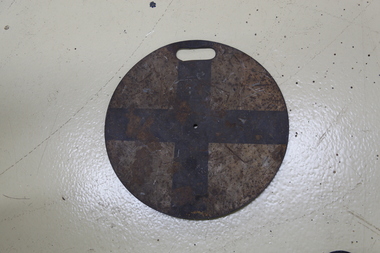
Train Destination Disc
Train Destination Disc Until the 1980s Melbourne suburban trains used a system of discs by day, and illuminated market lights by night, to indicate their destination. Placed on the front of trains to advise a Signalman in the Signal Box the destination of the train. This disk was used on NK1 the Whitfield Motor when it was used by Puffing Billy Railway Info from the diagrams from the 1953 Victorian Railways General Appendix. Black + is Lilydale, Belgrave other Destination Disks were Disks Williamstown Black II Newport Workshops Red = Changed in 76 to Black + Newport-Altona shuttle Red X Werribee Red X St Albans Black X Upfield Black = Broadmeadows Originally Red X changed in 1976 to Red = Epping Black II Hurstbridge Red X Lilydale, Belgrave Black + Alamein Black X Glen Waverley Black = Dandenong Black II Frankston Red = Sandringham Red X St Kilda Originally Black II changed in 1976 to Red X Port Melbourne Red X changed in 1976 to Black X Flinders St - Spencer St Local Red II Showgrounds Red = plus extra white disk on opposite front disk bracket; if only one event, Display Large White 1 and yellow side disk with set number. If two events, second event special trains flip this disk and show large Black Disk with white numeral 2 Race Special Red = plus extra white disk on opposite front disk bracket; if only one event, Display Large White 1 and yellow side disk with set number. If two events, second event special trains flip this disk and show large Black Disk with white numeral 2 For example, Flemington Race trains and Caulfield Race trains on the same day. Flemington carries Red = and White 1 and yellow set number on the side Caulfield carries Red = and Black 2 with yellow set number disc on the side. There was one disc which was never to be used in normal traffic, that was the "Red Cross"; it was reserved for Red Cross trains only.Historic - Victorian Railways - Destination Disk - Black cross - Lilydale, Belgrave Lines This disk was used on NK1 the Whitfield Motor when it was used by Puffing Billy Railway Train Destination Disc Round tin sign painted white with a black cross on white background and a mounting bracket on the rear. Placed on the front of trains prior to the mid 1970s to advise a Signalman in the Signal Box the destination of the train. Black Cross puffing billy, destination disc, victorian railways, lilydale, belgrave lines -
 Marysville & District Historical Society
Ephemera (Item) - Book page, Unknown
A page from a unknown book regarding Marysville and the surrounding district including Narbethong, Healesville and Warburton.A page from a unknown book regarding Marysville and the surrounding district including Narbethong, Healesville and Warburton.marysville, victoria, narbethong, healesville, warburton, toolangi, launching place, box hill, ringwood, lilydale, watts river, yea river, sylvia falls, don road, wood's point, baw baws, maroondah reservoir, graceburn weir, mt juliet, fernshaw -
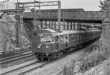
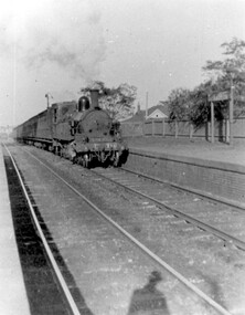 Surrey Hills Historical Society Collection
Photograph, D716 steam train at Mont Albert Station, 1919, 1919
The photo was taken at 8.15am on Friday 12 September 1919. The D class was a passenger and mixed traffic steam locomotive which operated on the Victorian Railways from 1902 to 1974. Originally it was introduced on mainline express passenger services, but they were quickly superseded by the much larger A2 class and were relegated to secondary and branch line passenger and goods service, where they continued in service for the next fifty years. The D716 was probably built at the Newport Workshops, post 1910 and before 1914. The expansion of Melbourne's population into new suburbs early in the 20th century, and the delay of the suburban electrification project, meant there was the need for faster and more powerful steam locomotives for the suburban rail network. In 1908, the basic design was adapted to create a more powerful locomotive. They were put to work on longer and hillier suburban routes including the Lilydale line. A total of 58 were built between 1908 and 1913. See wikipedia for a more detailed history of the D class locomotives. Electric trains replaced steam in 1922. Mr William Holmes of 'Lugano', Mont Albert Road was in charge of the design and introduction of the electrification of the Melbourne rail system.Black and white photo of a steam train approaching the platform at Mont Albert station. Rear in blue biro in Jocelyn Hall's handwriting: "Hamilton St Mont Albert / probably 1919".mont albert station, railways, trains, d class locomotives, norman carter, steam trains -
 Eltham District Historical Society Inc
Photograph, Henley Bridge, Spring Excursion, Exploring the Upper Yarra, 22 October 1995, 22/10/1995
[article by Bettina Woodburn in EDHS Newsletter No. 105, November 1995:] EXPLORING THE UPPER YARRA - We enjoyed the Spring Excursion, this year "Exploring the Upper Yarra" - in spite of the constant rain and the countryside under the cloud cover, especially in the valleys, being mainly shiny shades of green. The occasional fields of buttercups, clumps of arum lilies and splendid rhododendron and other flowering bushes became very special. The Cobb and Co coach was warm and a cosy retreat as we zig-zagged on the highways and byways to glimpse the Yarra River, upstream and down, its secret places, and particularly the many bridges. Russell excelled as 'Poet Laureate', reading from Dacre Smyth's book. This 1979 publication includes paintings of all the bridges along the river with poems and brief descriptions of each one. Some of the bridges are in out-of-the-way places and are not very well known. We looked forward to hearing the poetry as much as seeing the 'constructions'… Big Pat (was he short or tall, lean or fat? - he did win the £200 reward for discovering gold and had the creek named after him), about the 'Eddies'?, and the disliked 'meccano' bridge in Warburton, etc. etc. The hot roast lunch in the old Reefton Hotel was also most welcome. It was easy to imagine it peopled by miners and early settlers. Starting by crossing the new (1974) concrete bridge at Warrandyte we headed through Wonga Park with views to the Christmas Hills and to the escarpment of the Yering Gorge, which causes flood waters to back up through the Yarra Glen plain, so avoiding disasters downstream. At the end of a long driveway we found the wooden, privately owned Henley Bridge (1935 after the 1934 floods). This facilitates access to different parts of Henley Farm and to Lilydale. Everard Park, named after Blanche Shallard's father, a State Member for 17 years, below the Highway Yarra crossing was in need of care. It is 10 miles from Yarra Glen by road but, as "Yarra Marra” canoeists well know, 32 winding miles down by water. After more delightful countryside scenes we joined the Warburton Highway at Woori Yallock. From the old Railway Station at Launching Place the Centennial Trail for walkers, cyclists and horse riders has replaced the rails. The line from Lilydale was opened in 1901, and the last diesel freight train ran to Warburton in 1965. It continued to rain as we had morning tea in Warburton in a shelter between footbridges. From here we continued upstream past the Bridge to O'Shannassy Lodge and Reservoir, Starvation Creek, and the Peninsular tunnel (miners dug it as at Pound Bend) which we visited (scrambling down those steps!) on our return after lunch. Our furthermost point was the Upper Yarra Dam Reserve (and vast catchment area). Finished in 1957 after ten years' work and 100 years after Yan Yean, it supplies much of Melbourne's water. After crossing the 30m Launching Place Bridge to the Eltham side of the Yarra and Healesville, we saw in the distance the Yarra Glen Timber Trestle Bridge over the river flats "the longest for years in the land it was said!" Harry's dream of "better weather over the Divide" unfortunately didn't come true, but I'm sure we 36 members will retain happy memories of a day that was wet and green and filled with Bridges. Situated on the Yarra River, 5.5 kms south of Christmas Hills on private property. This timber trestle bridge is said to have been built some time after 1907 by Melbourne master-builder, David Mitchell (the father of Dame Nellie Melba), to connect his two "Henley Farm" properties with Lilydale. In earlier days, when the McPhersons owned the property, their children used a punt to cross the river to attend Yering Primary School. This private bridge is best viewed from the end of Wendy Way. - Source: Christmas Hills Past and Present, Yarra Glen & District Historical Society, 2004.Two colour photographsactivities, henley bridge, upper yarra -
 Kew Historical Society Inc
Photograph - The last train at Barker Station, 1952
The Kew railway was opened in 1887, and diverged from the main (Box Hill–Lilydale) line about half-way between Hawthorn and Glenferrie. From the point of divergence the line was slightly less than one mile long, and it had only one intermediate station — Barker. There were four road over-bridges and two level crossings, including one over the busy Barkers Road. The line supported a passenger and goods service, and was electrified in December 1922, at the same time as the main line to Box Hill. There were a number of peak hour services which ran from Flinders Street station (Melbourne) to Kew, but in 1938 all but one of these were diverted to the Ashburton line, where traffic was growing. This had an adverse effect on Kew traffic, as passengers from Kew needed to cross over a footbridge at Hawthorn to change trains, and the main line trains were usually already crowded by the time they reached Hawthorn. At about the same time the off-peak trains were replaced by road buses. In 1952 all passenger trains were withdrawn, but the road bus service continued for many years. Goods trains were finally withdrawn in 1957, and the railway was dismantled in 1958-59. (Source: Frank Stamford, 'The Hawthorn - Kew Railway')Small black and white snapshot of the last passenger train at Barker Railway Station in 1952. The photograph, one of 12, is part of a larger album of newspaper clippings, timetables, tickets and photos relating to the Kew Railway Line, taken and compiled by Lachlan Richardson, while a resident of Kew. The album dates from the 1950s. The album is part of a larger subject file on the Kew Line, compiled over time by members of the Kew Historical Society."Last train at Barker Station / 1 August 1952"kew railway line, transport -- railways -- kew (vic.), barker railway station, kew branch line -
 Kew Historical Society Inc
Photograph - Barker Station, August 1952
The Kew railway was opened in 1887, and diverged from the main (Box Hill–Lilydale) line about half-way between Hawthorn and Glenferrie. From the point of divergence the line was slightly less than one mile long, and it had only one intermediate station — Barker. There were four road over-bridges and two level crossings, including one over the busy Barkers Road. The line supported a passenger and goods service, and was electrified in December 1922, at the same time as the main line to Box Hill. There were a number of peak hour services which ran from Flinders Street station (Melbourne) to Kew, but in 1938 all but one of these were diverted to the Ashburton line, where traffic was growing. This had an adverse effect on Kew traffic, as passengers from Kew needed to cross over a footbridge at Hawthorn to change trains, and the main line trains were usually already crowded by the time they reached Hawthorn. At about the same time the off-peak trains were replaced by road buses. In 1952 all passenger trains were withdrawn, but the road bus service continued for many years. Goods trains were finally withdrawn in 1957, and the railway was dismantled in 1958-59. (Source: Frank Stamford, 'The Hawthorn - Kew Railway')Small black and white snapshot of the last passenger train at Barker Railway Station in 1952. The photograph, one of 12, is part of a larger album of newspaper clippings, timetables, tickets and photos relating to the Kew Railway Line, taken and compiled by Lachlan Richardson, while a resident of Kew. The album dates from the 1950s. The album is part of a larger subject file on the Kew Line, compiled over time by members of the Kew Historical Society."Barker Station / August 1952"kew railway line, transport -- railways -- kew (vic.), barker railway station, kew branch line -
 Kew Historical Society Inc
Photograph - Kew Railway Station: Denmark Street entrance, 1952
The Kew railway was opened in 1887, and diverged from the main (Box Hill–Lilydale) line about half-way between Hawthorn and Glenferrie. From the point of divergence the line was slightly less than one mile long, and it had only one intermediate station — Barker. There were four road over-bridges and two level crossings, including one over the busy Barkers Road. The line supported a passenger and goods service, and was electrified in December 1922, at the same time as the main line to Box Hill. There were a number of peak hour services which ran from Flinders Street station (Melbourne) to Kew, but in 1938 all but one of these were diverted to the Ashburton line, where traffic was growing. This had an adverse effect on Kew traffic, as passengers from Kew needed to cross over a footbridge at Hawthorn to change trains, and the main line trains were usually already crowded by the time they reached Hawthorn. At about the same time the off-peak trains were replaced by road buses. In 1952 all passenger trains were withdrawn, but the road bus service continued for many years. Goods trains were finally withdrawn in 1957, and the railway was dismantled in 1958-59. (Source: Frank Stamford, 'The Hawthorn - Kew Railway')Small black and white snapshot of the entrance to Kew Station from Denmark Street in 1952. The photograph, one of 12, is part of a larger album of newspaper clippings, timetables, tickets and photos relating to the Kew Railway Line, taken and compiled by Lachlan Richardson, while a resident of Kew. The album dates from the 1950s. The album is part of a larger subject file on the Kew Line, compiled over time by members of the Kew Historical Society.kew railway line, transport -- railways -- kew (vic.), kew branch line, kew railway station -
 Kew Historical Society Inc
Photograph - Kew Station 22/4/51, F3
The Kew railway was opened in 1887, and diverged from the main (Box Hill–Lilydale) line about half-way between Hawthorn and Glenferrie. From the point of divergence the line was slightly less than one mile long, and it had only one intermediate station — Barker. There were four road over-bridges and two level crossings, including one over the busy Barkers Road. The line supported a passenger and goods service, and was electrified in December 1922, at the same time as the main line to Box Hill. There were a number of peak hour services which ran from Flinders Street station (Melbourne) to Kew, but in 1938 all but one of these were diverted to the Ashburton line, where traffic was growing. This had an adverse effect on Kew traffic, as passengers from Kew needed to cross over a footbridge at Hawthorn to change trains, and the main line trains were usually already crowded by the time they reached Hawthorn. At about the same time the off-peak trains were replaced by road buses. In 1952 all passenger trains were withdrawn, but the road bus service continued for many years. Goods trains were finally withdrawn in 1957, and the railway was dismantled in 1958-59. (Source: Frank Stamford, 'The Hawthorn - Kew Railway')Small black and white snapshot of Kew Railway Station, looking south to Barker Station. The photograph, one of 12, is part of a larger album of newspaper clippings, timetables, tickets and photos relating to the Kew Railway Line, taken and compiled by Lachlan Richardson, while a resident of Kew. The album dates from the 1950s. The album is part of a larger subject file on the Kew Line, compiled over time by members of the Kew Historical Society.kew railway line, transport -- railways -- kew (vic.), kew branch line, kew railway station -
 Kew Historical Society Inc
Photograph - Kew Branch Line : The Hawthorn Grove crossing, August 1952
The Kew railway was opened in 1887, and diverged from the main (Box Hill–Lilydale) line about half-way between Hawthorn and Glenferrie. From the point of divergence the line was slightly less than one mile long, and it had only one intermediate station — Barker. There were four road over-bridges and two level crossings, including one over the busy Barkers Road. The line supported a passenger and goods service, and was electrified in December 1922, at the same time as the main line to Box Hill. There were a number of peak hour services which ran from Flinders Street station (Melbourne) to Kew, but in 1938 all but one of these were diverted to the Ashburton line, where traffic was growing. This had an adverse effect on Kew traffic, as passengers from Kew needed to cross over a footbridge at Hawthorn to change trains, and the main line trains were usually already crowded by the time they reached Hawthorn. At about the same time the off-peak trains were replaced by road buses. In 1952 all passenger trains were withdrawn, but the road bus service continued for many years. Goods trains were finally withdrawn in 1957, and the railway was dismantled in 1958-59. (Source: Frank Stamford, 'The Hawthorn - Kew Railway')Small black and white snapshot of the Hawthorn Grove crossing, August 1952. The photograph, one of 12, is part of a larger album of newspaper clippings, timetables, tickets and photos relating to the Kew Railway Line, taken and compiled by Lachlan Richardson, while a resident of Kew. The album dates from the 1950s. The album is part of a larger subject file on the Kew Line, compiled over time by members of the Kew Historical Society.kew railway line, transport -- railways -- kew (vic.), kew branch line, hawthorn grove -- hawthorn (vic.), railway crossings -
 Kew Historical Society Inc
Photograph - Seven Carriage Train at Barker Station
The Kew railway was opened in 1887, and diverged from the main (Box Hill–Lilydale) line about half-way between Hawthorn and Glenferrie. From the point of divergence the line was slightly less than one mile long, and it had only one intermediate station — Barker. There were four road over-bridges and two level crossings, including one over the busy Barkers Road. The line supported a passenger and goods service, and was electrified in December 1922, at the same time as the main line to Box Hill. There were a number of peak hour services which ran from Flinders Street station (Melbourne) to Kew, but in 1938 all but one of these were diverted to the Ashburton line, where traffic was growing. This had an adverse effect on Kew traffic, as passengers from Kew needed to cross over a footbridge at Hawthorn to change trains, and the main line trains were usually already crowded by the time they reached Hawthorn. At about the same time the off-peak trains were replaced by road buses. In 1952 all passenger trains were withdrawn, but the road bus service continued for many years. Goods trains were finally withdrawn in 1957, and the railway was dismantled in 1958-59. (Source: Frank Stamford, 'The Hawthorn - Kew Railway')Small black and white snapshot of a seven carriage train approaching Barker Railway Station. The photograph, one of 12, is part of a larger album of newspaper clippings, timetables, tickets and photos relating to the Kew Railway Line, taken and compiled by Lachlan Richardson, while a resident of Kew. The album dates from the 1950s. The album is part of a larger subject file on the Kew Line, compiled over time by members of the Kew Historical Society."Seven Carriage Train at Barker Station"kew railway line, transport -- railways -- kew (vic.), barker railway station, kew branch line