Showing 518 items
matching map of mine
-
 Stawell Historical Society Inc
Map, Stawell Gold Mine, Plan of Surface Topographical Detail, 27 March 2007
... Detail Map Stawell Gold Mine ...Stawell Victoria Showing Magdala Decline as at 27 March 2007 Stawell Gold Mines mining, gold -
Koorie Heritage Trust
Book, Roberts, Jan, Massacres to mining : the colonisation of Aboriginal Australia, 1981
"If you take a people from their land and homes they will die. The mining, pastoral, forestry and tourism bodies are doing this every day of the year in Australia. But, more importantly, as this land - and in fact all things - are a part of us as we are a part of them both physically and spiritually, then to destroy all that - the environment- is to destroy the people. Massacre!"198 p.; maps; figs; ill.; index; 24 cm."If you take a people from their land and homes they will die. The mining, pastoral, forestry and tourism bodies are doing this every day of the year in Australia. But, more importantly, as this land - and in fact all things - are a part of us as we are a part of them both physically and spiritually, then to destroy all that - the environment- is to destroy the people. Massacre!"australian aborigines. treatment by white australians. | aboriginal australians -- treatment. | australia -- colonization -- history.massacres-aborigines, australia, | weipa mine-land dispossession, | mining companies-australia, | land rights-history -
Koorie Heritage Trust
Book, Bowden, Keith MacRae, Goldrush doctors at Ballaarat, 1977
An historical account of events and doctors during the goldrush era at Ballarat.xiii, 125 p. : ill. (part col.), map ; 1977An historical account of events and doctors during the goldrush era at Ballarat. doctors. victoria. ballarat. gold fields, 1850-1860. | physicians -- ballarat, victoria -- history. | gold mines and mining -- victoria -- ballarat. -
Koorie Heritage Trust
Book, Baragwanath, W, Memoirs of the Geological Survey of Victoria : No. 15 The Aberfeldy District, Gippsland, 1925
... . II. Victoria. Dept. of Mines. 15 v. : ill., plates, maps ...15 v. : ill., plates, maps, plans, diagrs. ; 34 cm. lcsh: 1. geology -- victoria -- periodicals. 2. geology -- victoria. i. geological survey of victoria. ii. victoria. dept. of mines. -
 Rutherglen Historical Society
Map, 1908
... Underground Mine Map... Chiltern Underground Mine Map Geological Survey Reef Drives ...This is a map produced as part of a book entitled.. It is also stamped on the back in blue ink with an oval ring and the words North of England Institute. Newcastle. Mining & Meterolgical Faculty. Purchased on 23rd July 2017 by the Society after research by member Simon Killeen. Mining map of one of the first mines in Rutherglen area ( Chiltern West)Cream paper, black printing, rectangle with a drawingGeographical Survey of Victoria, Memoir, No6. Plate XX Plan of Underground Workings CHILTERN VALLEY CONSOLS MINE, RUTHERGLEN, PARISH OF CHILTERN WESTgold, rutherglen, mining, chiltern, underground mine map, geological survey, reef drives -
 Ballarat Tramway Museum
Map, Electric Supply Co. of Vic (ESCo), Ballarat Electoral Map - ESCo, 1900
Document prepared by the Electric Supply Co of Victoria, as part of an order under the Electric Light and Power Act 1896, section 5 of order No. 17 granted to company. Dated 19/2/1901 and signed by the Postmaster-General. Shows the order area being parts of the City of Ballaarat, Sebastopol and Ballarat East. Shows the street names, boundaries, principal power line routes, land reserves, parks, mine locations, railways and Lake Wendouree. Signed by R L Williams Town Clerk City of Ballarat, J R Hall for the Borough of Sebastopol, and John Gent for the Town of Ballarat EastYields information about the power supply to the Ballarat area.Cloth backed paper map, coloured and marked up as exhibit 17.Notes in ink including the signature of Benjamin Deakin 24/9/00 and certified by the three involved municipal Town Clerks.ballarat power supply, esco, electric supply co of victoria, city of ballaarat, east ballarat, sebastopol, orders, power lines, power supply -
 Ballarat Tramway Museum
Book, E.D. Jenkins and Lloyd Jenkins, "Sebastopol Victoria - A Historical Survey of Early Sebastopol - 1864- 1964", 1989
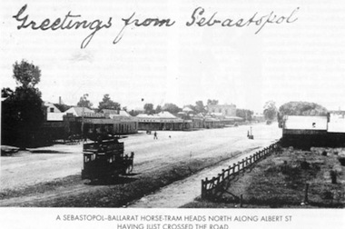
Book - 92 pages plus card covers, a historical survey of the Sebastopol district. Originally written by E.D. Jenkins for the Borough of Sebastopol's centenary in 1964, reprinted with additional text by Lloyd Jenkins to recognise the 125th anniversary of the Borough covering the years 1965 to 1989. Book covers mining history, churches, the Borough Council, early days of the district and various points, eg cabmen, horse trams and electric trams, schools, the Mechanics Institute, various clubs, fire brigade, hotels, industries, and programme of events to celebrate the centenary. The second part of the book, covering the period is laid out in a chronological order with forward by Cr. Donald, the Mayor with many photographs. Centre page has a large map of the district showing the many mines, leads, roads and other historic locations. Tramway photos are horse tram No. 7, ESCo 17 at depot (all on file) and a photo showing a horse tram heading north along Albert St. with the shopping centre in the background - see image. Photo taken just after the tram has crossed the roadway. Copy of the horse tram heading north along Albert St. made Oct. 2001 for the "gold, Gold GOLD" temporary exhibition - colour laser print onto card, with Velcro dots on rear. Stored in box D1 (Display Box) 02/2003. See Reg Item 3883 for another print of this photograph.On page 3 in black ink "Ballarat Tramway Museum Inc. With compliments, D.L. Jenkins 14/4/1999"trams, tramways, sebastopol, local history, public transport, mining, horse trams, esco -
 Bendigo Historical Society Inc.
Map - OLD TOM MINE, WHIPSTICK
... ' Map OLD TOM MINE, WHIPSTICK ...2 copies ( A4 and A3) of Old Tom lease. Map shows Old Tom Reef, old working open cutting, shaft 150 ft., Easter Reef, dam sand heap, water race, 3 other shafts, 120ft., 90ft., and 500 ft. marked on map. Stamped on map '64.3.34' Written on bottom of map in handwriting ' Old Tom Lease, Parish of Huntly, County of Bendigo, Mining district of Sandhurst'bendigo, mining, old tom lease map -
 Bendigo Historical Society Inc.
Document - MCCOLL, RANKIN AND STANISTREET COLLECTION: LEASE AGREEMENT, 24th November, 1933
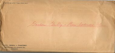
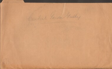
Manilla Envelope containing 3 copies of a Lease agreement between John Taylor of California Gully and John Severn Barker of Jobs Gully for a company called the Garden Gully and Moon Extended Gold Mines NL. These men are the holders of an application for Gold Mining lease 10073 comprising about 90 acres in the Parishes of Yarraberb and Neilborough. The company is being formed to acquire the application for the lease and to carry out mining operations on and in the land comprised in the lease application. Dated 24th November 1933. Also in the envelope is a lease document for mining Lease No. 9993, for the Central Garden Gully Gold Mining Co. NL which includes a map of the lease. Written in pencil on the front of the lease is : allowed to lapse.gold, mining, lease agreement, gold mining, garden gully and moon extended mines, central garden gully -
 Bendigo Historical Society Inc.
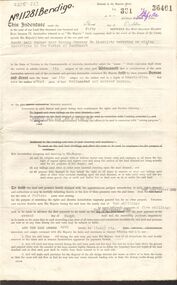
Document - MCCOLL, RANKIN AND STANISTREET COLLECTION: SITE LEASE, 3rd October, 1950
Mining site lease No. 11281. The lease of the site is for Machinery for the South Nell Gwynne Gold Mining Co., includes Map of the site. Dated 2nd September 1950.gold, mining, lease, bendigo, gold mines, mining lease, south nerll gwynne gold mining co. -
 Bendigo Historical Society Inc.
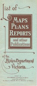
Document - LIST OF MAPS, PLANS, REPORTS PUBLISHED BY MINES DEPARTMENT VICTORIA 1938
... of Mines. Blue booklet, on front ' List of Maps, Plans, Reports ...Blue booklet, on front ' List of Maps, Plans, Reports and other publications of the Mines Department of Victoria. Issued by Geo Brown Secretary for Mines under the authority of The Hon. E.J. Hogan, MLA, Minister of Mines. Booklet contains list of publications of geological reports, maps etc for Ararat, Ballarat, Beechworth, Bendigo, Castlemaine, Gippsland, Maryborough.Geo Brown, Secretary for Mines under the authority of The Hon.E.J. Hogan, M.L.A. Minister of Mines.organisation, government, geological maps list -
 Bendigo Historical Society Inc.
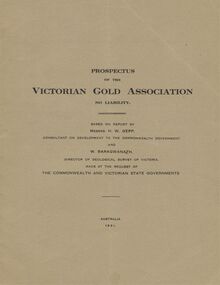
Document - MCCOLL, RANKIN AND STANISTREET COLLECTION: VICTORIAN GOLD ASSOCIATION, 1931
... and the Monument Hill Mine. 12 pages including maps and Transverse Sections... Mine. 12 pages including maps and Transverse Sections ...Prospectus of the Victorian Gold Association N.L. Based on a report by Messrs H. W. Gepp Consultant on Development to the Commonwealth Government and W. Baragwanath, Director of the Geological Survey of Victoria. Dated 1931 This company was formed to investigate the Deborah Mine, The Central Nell Gwynne Mine and the Monument Hill Mine. 12 pages including maps and Transverse Sections of the MinesThe Commonwealth and Victorian State Governments. E. Whitehead & Co., Pty., Ltd Printers 21 Equitale Place, Melbourne, C1.gold, mining, prospectus, bendigo, gold mines, victorian gold associatian, deborah mine, central nell gwynne mine, monument hill mine. -
 Bendigo Historical Society Inc.
Document - MCCOLL, RANKIN AND STANISTREET COLLECTION: CENTRAL GARDEN GULLY
Manilla Folder containing correspondence and applications for a mining lease on the Garden Gully Line known as Mumford's Claim, also contains maps of lease numbers 9993, 10173, and 10390 (all on the Garden Gully Line).McColl Rankin & Stanistreet, Charing Cross Bendigogold mining, miners' safety cage, central garden gully, mining, gold mines, bendigo, garden gully, mumfords claim -
 Bendigo Historical Society Inc.
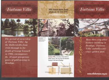
Document - FORTUNA COLLECTION: FORTUNA VILLA
Coloured tri-fold brochure titled Fortuna Villa. There are several coloured photos of the Villa and garden, a short history, information on the Villa Fortuna Action Group and their ideas for its future use. There is also a printed membership form. A small location map is included.bendigo, clubs, fortuna villa, christopher ballerstedt, theodore ballerstedt, 180 mine, george lansell, edith lansell, william beebe, vahland, getzschmann, emil maumann, commonwealth department of defence, the fortuna villa action group, city of greater bendigo, julian prowd, geoff hocking, bart-n-print -
 Bendigo Historical Society Inc.
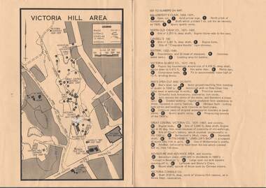
Map - VICTORIA HILL AREA
... Claim Victoria Hill Reserve Mines Dept Reervation Map ...Map of Victoria Hill Area printed on yellow paper. Details of tracks, cuttings, contours (in Metres) and Anticline. Location of mines, open cuts and buildings are shown. Numbers on map are: Ballerstedt's Claim 1 - 5; North Old Chum Co. 6; Lansell's 180, 7,8,11; Battery 9.10.12; Victoria Quartz Co. 13 - 17; Rae's Open Cut and Vicinity 18 - 28, Great Central Victoria Co 29 - 36, Adventure and Advance Area and vicinity 37 - 40 and Victoria Consols Co 41.map, bendigo, victoria hill, victoria hill area, victoria consols, new chum anticline, great central victoria, rae's open cut, w rae's home, victoria quartz, ballerstedt's open cut, lansell's 180, north old chum, central nell gwynne, john brown factory, gold mines hotel, cleopatra needle type chimney, floyd's battery, ballerstedt's 24yd claim, humboldt shaft, wittscheibe's jeweller's shop, luffsman and sterry's claim, victoria hill reserve, mines dept reervation -
 Bendigo Historical Society Inc.
Document - PETER ELLIS COLLECTION: A GUIDE FOR DRIVERS ON THE WHIPSTICK TOUR
A Guide for Drivers on the Whipstick Tour. First page gives assembly area, driving in convoy and negotiating water or boggy patches across the road. Amended written at the end of the page. Directions with mileage and items of interest for the tour on Sunday September 9th (no year). A Whipstick Map 1971 showing State Forest, Crown Lands, Uncleared Mallee - Private (shown in different colours) Water Reserve and Roads. Noted are Flora and Fauna - Plants, Birds & Mammals, and areas of State Forest and Southern State Forest with Mallee Scrub area noted. Also State Forest & Crown Lands Total Area and a map scale. The Bendigo Whipstick mentions area, suggestions of where the name Whipstick came from, shrubs and flowers with their flowering times, descriptions of some of them and some information on the Mallee Fowl. The Eucalyptus Oil Industry paragraph mentions the beginnings of the industry. Mentioned are the different uses of oils (perfumery, industrial and medicinal) and the different species of eucalypt used for each and various products. Also notes on the growing, harvesting and refining of eucalyptus. P Ellis at the end of the page. The next two and a half pages mentions reserves, and at the end acknowledgements. Includes a spare copy of 'The Bendigo Whipstick' by P Ellis.bendigo, history, early bendigo, peter ellis collection, a guide for drivers on the whipstick tour, the whipstick 1971 map, shire of marong, shire of east loddon, shire of huntly, borough of eaglehawk, city of bendigo, shire of strathfieldsaye, the bendigo whipstick, eucalyptus oil industry, eaglehawk town hall, lightning hill lookout, eaglehawk rifle range, new moon mines, blue jacket reservoir, maggetti's wine hall, camp hotel (ex), skylark dam, eucalyptus oil production, eucalyptus factory, whipstick eucalyptus farm, ruedin's eucalyptus factory, dutch bowls, governor philip, sir joseph banks, john white, baron von mueller, joseph bosisto, commonwealth government, perfumery oils, industrial oils, medicinal oils, p ellis, dr frith, csiro wildlife division, harley webster, forests commission, vincent serventy, victorian national parks association, bendigo field naturalists club -
 Bendigo Historical Society Inc.
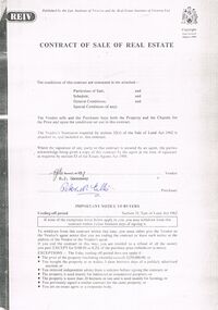
Document - PETER ELLIS COLLECTION: CONTRACT OF SALE
Copy of Contract of Sale of Real Estate and associated papers for property located in Flora Lane, Flora Hill which was purchased by Peter Ellis on 26 May 1993. Contract is in booklet with other loose papers. Contract includes General Conditions, Particulars of Sale, Special Conditions, Guarantee, Vendors Statement to the Purchaser, Shire of Strathfieldsaye Land Information Certificate, Planning Certificate Request for Building Approval Particulars, Coliban Region Water Authority Information Statement, Property Inquiry Application Form, Request for Property Information from Vic roads, Advice on Mine Subsidence Hazard (Department of Energy & Minerals), Map, Copy of Certificate of Title and Folder Numbers. Loose pages include Building Control Act 1981 Inspection Notice, two plans of building, Three plans (Coliban Water Asset Location) of Flora Lane where property is situated, 2 dated 13/11/2007 (have New Carport drawn beside house) and 1 dated 22/11/2007. Last page has specifications for car port.bendigo, house, peter ellis oam, peter ellis collection, reiv, law institute of victoria, real estate institute of victoria ltd, e j gannaway, peter n ellis, ray white bendigo pty ltd, e m monotti & son, rogers and every, craig watts, shire of strathfieldsaye, coliban region water authority, sec, g & fc of vic, telecom, vicroads, bruce l phillips, k deps?, department of energy and minerals, robert james sanderson, t flanagan, land titles office victoria, harston partridge & co pty ltd -
 Bendigo Historical Society Inc.
Slide - DIGGERS & MINING. GETTING THE GOLD, c1860
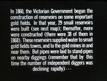
Diggers & Mining. Getting the Gold. Slide: In 1860, the Victorian Government began the construction of Reservoirs on some important gold fields. In that year, 29 small reservoirs were built (see next map); thereafter, more were constructed (there were 38 of them in 1868). These reservoirs supplied water to small gold fields towns, and to the gold mines in and near them. But pipes were laid to stand-pipes on nearby diggings (remember that by this time the number of independent diggers was declining rapidly) Markings: 71 994.LIF:4. Used as a teaching aid.hanimounteducation, tertiary, goldfields -
 Bendigo Historical Society Inc.
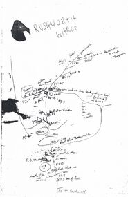
Map - PETER ELLIS COLLECTION: MAP
... mentioned is the Balaclava Hill Open Cut Mine. Map PETER ELLIS ...Five photocopies of drawings of the Rushworth area and three copies of Rushworth-Whroo. All maps have various features and some plants noted. Also mentioned is the Balaclava Hill Open Cut Mine.map, victoria, rushworth/whroo, peter ellis collection, rushworth, whroo, aboriginal water holes, balaclava hill open cut mine -
 Bendigo Historical Society Inc.
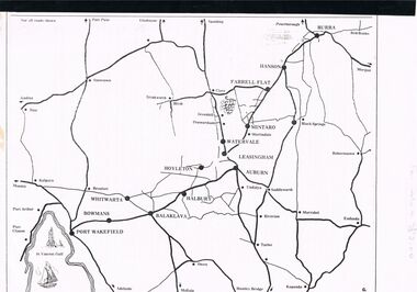
Document - GERMAN HERITAGE SOCIETY COLLECTION: BUILDINGS, MINES & PLACES
Collection of Articles with a map of part of South Australia north of Adelaide. Contains articles and photos about Tailem Bend, Murray Bridge, Kapunda, Burra, Clare, Penwortham, Sevenhill, Eudunda, Mintaro, Watervale, The House of Quelltaler, Leasingham and Auburn. It also contains a story by Gaye Sprenglewski.societies, service clubs, german heritage society, german heritage society collection - colllection of articles about buildings, mines & places, tailem bend, murray bridge, kapunda, burra, clare, penwortham, sevenhill, eudunda, mintaro, watervale, the house of quelltaler, leasingham, auburn, gaye sprenglewski. -
 Bendigo Historical Society Inc.
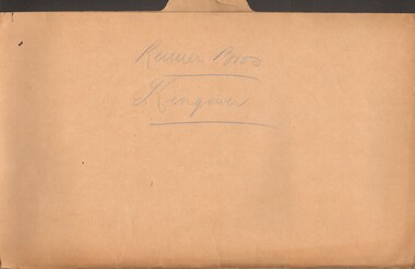
Document - MCCOLL, RANKIN AND STANISTREET COLLECTION: REIMER BROS. KINGOWER
Manilla folder containing correspondence relating to Reimer Brothers claim at Kingower, also contains a large scale parish map of Kingower showing the position of the claim and leases 6278 held by Andrew Thomas Berriman and 6279 held by Florence Adelaide BerrimanMcColl Rankin & Stanistreetgold mining, miners' safety cage, kingower/union reef mines, gold mining, kingower, reimer brothers berriman -
 Bendigo Historical Society Inc.
Document - MCCOLL, RANKIN AND STANISTREET COLLECTION: SUNDRY REPORTS, 1930's
Manilla Folder containing reports from various mines in Bendigo and surrounding areas. 1. 4 page typewritten report on the Balaclava Hill Mine at Rushworth and some newspaper clippings about the mine with a plan of the underground workings; 2. Page from the Árgus' dated 2nd August 1900 featuring an article on the survey of the Garden line of Reefs; 3. 5 page report with maps on the Tooleen Gold Field; 4. Single page report about an unnamed mining area claimed to be on the southern end of the Deborah line of reef. (this could be the 'Three Jays' mine in Sedgwick. P. Wilkin); 5. Hand written report on the Coronation Mine, 2 miles east of Walhalla.; 6. Hand written report dated 1935, of the Queen Mary mine, St. Arnaud.; 7. 1932 report on the North Neangar lease.; 8 4 page report on the Kings Prize Gold Mining Syndicate.; 9. Description of the plant of the Marong Alluvial Company? Also a guide for marking out leases.; 10. Crushing details (1 page) from the 'Enterprise' Mine South of and adjacent to Perseverence.; 11. 1 page crushing details from Rowe Brothers, Mosquito Mine, Fryerstown.; 12 hand written report mentions Arthur Hatfield, Scarsdale.; 13. Map with lines of reef showing the position of the New Moon Consolidated and the New Moon United shafts.; 14, Large scale map from Harrison/Victoria street to Havilah Road showing the positions of the Carlisle, North Garden and Unity Shafts.gold mining, miners' safety cage, sundry reports, mining. bendigo, rushworth, balaclava hill, garden line of reef, toolleen, coronation mine, walhalla, queen mary mine, st. arnaud. north neangar, kings prize gold mining syndicate, marong, enterprise mine, perseverence, rowe brothers, mosquito mine, fryerstown, arthur hatfield, scarsdale, new moon consolidate, new moon united, carlisle, north garden, unity. -
 Bendigo Historical Society Inc.
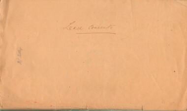
Document - MCCOLL, RANKIN AND STANISTREET COLLECTION: LEASE CONSENTS
Manilla Folder containing correspondence and consents relating to the following Gold Mining Leases; 10819, 10027 (North Virginia Gold Mining Co.);, 10370 Great Eastern (Bendigo), includes map; 10014, South monument; 10059 North Neanger, with map; 10072 ; 10104; North Virginia; 10068 New Don Company with Map; 10032 New Balaclava, Whroo; 10026 East Clarence Gold M/C. Dated 1933 - 34gold mines, bendigo, gold mines, north virginia, great eastern, south monument, north neanger, new don, east clarence, new balaclava -
 Bendigo Historical Society Inc.
Document - MCCOLL, RANKIN AND STANISTREET COLLECTION: TAMBOUR MAJOR LEASE, 1939/1940
Manilla Folder containing Lease application and correspondence for lease No. 11007 (Tambour Major). Includes Map of lease. Also references to lease Numbers 10168 and 10899. Dated September 1939McColl Rankin & Stanistreet, Charing Cross Bendigo.gold mining, miners' safety cage, tambour major lease, gold mines, bendigo tambour major -
Bendigo Historical Society Inc.
Photograph - Aerial shots of parts of Bendigo 1934, 1934
... history bendigo bendigo mines bendigo maps bendigo aerial photos ...AERIAL SHOTS OF PARTS OF BENDIGO 1934 Catalogue No.10584 This document contains scans of a unique set of aerial photographs that were taken over the City of Bendigo on Friday 12th January 1934, at about midday. The photographs were commissioned by Bendigo Mines Limited during their exploration and mining program designed to revitalize the Bendigo Goldfield. The photographs were given to the Victorian Mines Department sometime in the 1950s. The photographs were taken at a relatively low level of about 4000 feet. This gives a very detailed picture of Bendigo as it was in the 1930s. The photos cover the City Centre and are mainly of the goldfields on the south side of the city; the extent of which covers approximately the four corners of Myers Flat, Maiden Gully, Mandurang and One Tree Hill. Streets, roads and places of interest have been identified as best as possible in December 2023. There are 44 maps, and each references the adjoining maps.Typed Notes with CD The CD is one of two and contains a set of 46 images: The folder named "High_Resolution_800dpi" contains the original digital files that were produced by scanning the photographic prints (About A3 size) at 800 dpi using a high quality, large pformat, roll scanner. These files may be too large for some computers. A second CD contains a direstory called "Low_Resolution_300dep" The images in the folder names "Low_Reolution_300dpr" have a lower resolution (300 dpi) and have been rotated 90 degrees clockwise so that the Northern margin of each image is a the top of the screen. Clive Willman Senior Geologist Geological Survey of Victoriahistory, bendigo, bendigo mines, bendigo maps, bendigo aerial photos -
 Bendigo Historical Society Inc.
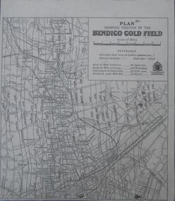
Map - Bendigo Gold Field
Plan showing portion of the Bendigo goldfield. Area of main goldfield: 140 square miles. Deepest mine working: 4593' (Victoria quartz). Gold output of field to 1935: 20,775,000 ounces. Dividends paid 1870-1935: 10,740,000 pounds.map, goldfield, bendigo -
 Bendigo Historical Society Inc.
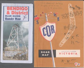
Map - Road maps
BHS CollectionTwo road maps. On, Bendigo & District blue guide handy map the other a road map of Victoria. On the back of the Bendigo map the date October 2000. On the Victoria map the words in pen "This doesn't belong to you, it is mine". L.J. Ellison and a blue stamp of Axedale service station. Aileen and John Ellison Collection.road map, victoria, bendigo -
 Bendigo Historical Society Inc.
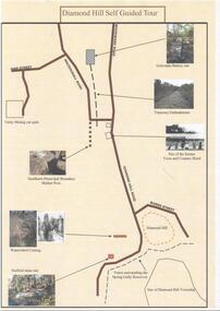
Document - DIAMOND HILL SELF GUIDED TOUR
One page coloured map of historical sites in the Diamond Hill area. Including the Golconda Battery site, Tramway Embankment, site of former Town and Country Hotel, Sandhurst Municipal Boundary Marker Post, Waterwheel Cutting, Stafford Mine site. On the back a description of the various sites. Produced by the Bendigo Historical Societybendigo, tourism, diamond hill -
Kew Historical Society Inc
Book, Geoff Hocking, Castlemaine : from camp to city 1835-1900, a pictorial history of Forest Creek & the Mount Alexander goldfields, 1994
230 p. : ill. (some col.), facsims, maps, ports. ; 22 x 25 cm.non-fictiongold mines and mining -- victoria -- castlemaine -- history, castlemaine (vic.) -- history -
Stawell Historical Society Inc
Map, Sloane and Scotchmans United mine 1916, 1916
... Sloane's & Scotchmans United Mine, Stawell large map.../1 Sloane and Scotchmans United mine 1916 Map ...Sloane's & Scotchmans United Mine, Stawell large map, heading across the top. Stamp on top right side 144/T/1stawell, mining