Showing 1408 items
matching maroondah
-
 Ringwood and District Historical Society
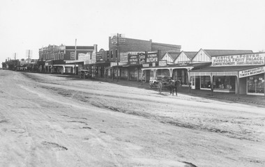
Photograph, Maroondah Highway Central, Ringwood. Shops in Main Street, 1926
Black and white photograph (2 copies) Typed below photograph: "Maroondah Hwy. 1926. Shops now Safeway and Eastland carparks". Written on rear of backing sheet: "Main St. 1926". Image shows unmade street lined with shops from Warrandyte Road to Melbourne Street. -
 Ringwood and District Historical Society
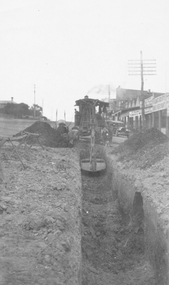
Photograph, Maroondah Highway Central, Ringwood. Laying water main in Main Street, 1935
Black and white photographImage shows excavator digging trench for water main on Main Road (Maroondah Highway. Towards the west, near the corner of Warrandyte Road. The Ringwood Stationmaster's house is on the left, Bamford's timber yard, Coffee Palace and other shops on right. -
 Ringwood and District Historical Society
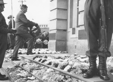
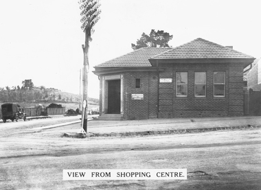
Photograph, Clocktower re-opening on corner Maroondah Highway and Wantirna Road, Ringwood - December 1967
Mr. Bill Kelly, R.S.L., laying a wreath at Ringwood Clocktower opening.Typed below photograph, 'Mr. Bill Kelly, R.S.L. at new position of clocktower'. Catalogue card reads, 'Clocktower re-opening. Mr. Bill Kelly laying wreath (R.S.L.) at clock in new position corner Maroondah Highway and Wantirna Road'. -
 Ringwood and District Historical Society
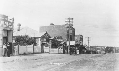
Photograph, Maroondah Highway Central, Ringwood. Looking east from opposite station entrance, 1918
Black and white photograph (3 copies- 2 large, 1 small)Typed below one large photograph: "Maroondah Highway Ringwood 1918 looking east - opposite station entrance. Old Post Office to left." Written on back of small photograph: "c1920. Godbehear was brother to Rev. Godbehear who died 1945". -
 Ringwood and District Historical Society
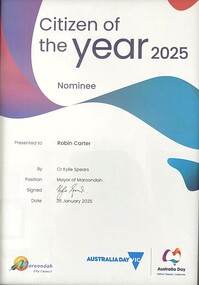
Award - Booklet and Certificate, Maroondah City Council Australia Day Awards & Australian Citizenship Ceremony, Sunday 26 January 2025
Programme for annual community awards and citizenship affirmation ceremonies. Citizen of the Year 2025 Nominee certificate - Robin Carter (RDHS)Welcome by Cr Kylie Spears, Mayor Thank you for joining us today at Maroondah City Council's Australia Day event at Ringwood Lake Park. Today is a free community event and an opportunity to celebrate our great city and nation in an inclusive and positive way. As Mayor, and for everyone attending the day, the Citizenship Ceremony will be a wonderful moment as we get to witness people from so many different countries embrace Australia, and Maroondah, as their new home. Citizenship is a representation of your commitment to the ideals and values of your adopted country, Australia. Becoming an Australian Citizen today indicates that you have chosen to take a significant step to be a full member of the Australian community. Maroondah City Council is especially proud that you have taken this step with us. On behalf of Council I also wish to congratulate all nominees in the Maroondah Australia Day Awards. I hope each nominee is proud of the contribution they make to our community. We appreciate your time and effort to make Maroondah a great place to live, work and play. While you're here, please take the time to discover this wonderful park and the facilities it offers, including the popular all-abilities playspace and the historical mining site (at the rear of the park) that provides an insight into the history of antimony mining in Ringwood in the 1870s. We hope you will enjoy the day with your family and friends. Awards include - Community Event of the Year - Maroondah Rotary Club Gala Night, Young Citizen of the Year - Shannon Freeman, and Citizen of the Year nominations - Kathy Adams, Ian Barnes, Andrew Brownlie, Heidi Butler-Moore, Robin Carter, Nicole Fernley, Marrianne Fry, Peter Rogers, Wendy Scott, Jonathon Tan, Heather Telford, Ken Weller. -
 Eltham District Historical Society Inc
Photograph, Liz Pidgeon, Heritage Excursion; Maroondah Aqueduct, 3 September 2016, 3 September 2016
Heritage Excursion - Maroondah Aqueduct Walk - Saturday 3rd September The Maroondah Aqueduct was once a major link in Melbourne’s water supply system. It was built between 1886 and 1891 to transfer water from the Watts River near Healesville to the Preston Reservoir. It was 66 km in length, made up of 41 km of open channel, 10 km of tunnel through hills and 15 km of pipeline across stream valleys known as inverted siphons. The section of the aqueduct through the Eltham area has been abandoned since the 1980s but the open channel has largely been retained. A recreational path follows the aqueduct reserve. For our excursion on 3rd September we intend to walk along the section of the aqueduct adjacent to Allendale Road. This is a section not visited on previous excursions and includes the transition from open channel to the inverted siphon across the Diamond Creek valley. Apart from the aqueduct itself the main feature of the walk is the extensive views across Eltham North and Diamond Creek. Along the way we will talk about the history of the aqueduct and the area. This easy walk is about 3 km return and will take 2 to 2.5 hours. It will start at 2pm at the junction of Allendale Road with Godber Road and Zig Zag Road North, officially Diamond Creek, but on the northern boundary of Eltham. (Melway ref.12 B10). Newsletter No., 229, August 2016 Abandoned and rusted house base probably purposed to water or feed cattle. Born Digitalmaroondah aqueduct, eltham north, activities, eltham district historical society, heritage excursion, bath, acqueduct trail -
 Eltham District Historical Society Inc
Photograph, Liz Pidgeon, Heritage Excursion; Maroondah Aqueduct, 3 September 2016, 3 September 2016
Heritage Excursion - Maroondah Aqueduct Walk - Saturday 3rd September The Maroondah Aqueduct was once a major link in Melbourne’s water supply system. It was built between 1886 and 1891 to transfer water from the Watts River near Healesville to the Preston Reservoir. It was 66 km in length, made up of 41 km of open channel, 10 km of tunnel through hills and 15 km of pipeline across stream valleys known as inverted siphons. The section of the aqueduct through the Eltham area has been abandoned since the 1980s but the open channel has largely been retained. A recreational path follows the aqueduct reserve. For our excursion on 3rd September we intend to walk along the section of the aqueduct adjacent to Allendale Road. This is a section not visited on previous excursions and includes the transition from open channel to the inverted siphon across the Diamond Creek valley. Apart from the aqueduct itself the main feature of the walk is the extensive views across Eltham North and Diamond Creek. Along the way we will talk about the history of the aqueduct and the area. This easy walk is about 3 km return and will take 2 to 2.5 hours. It will start at 2pm at the junction of Allendale Road with Godber Road and Zig Zag Road North, officially Diamond Creek, but on the northern boundary of Eltham. (Melway ref.12 B10). Newsletter No., 229, August 2016 Abandoned rusty farm machinery possibly used for tilling the soil - off the Aqueduct trail Born Digitalmaroondah aqueduct, eltham north, activities, eltham district historical society, heritage excursion, aqueduct trail, farm machinery -
 Eltham District Historical Society Inc
Photograph, Liz Pidgeon, Heritage Excursion; Maroondah Aqueduct, 3 September 2016, 3 September 2016
Heritage Excursion - Maroondah Aqueduct Walk - Saturday 3rd September The Maroondah Aqueduct was once a major link in Melbourne’s water supply system. It was built between 1886 and 1891 to transfer water from the Watts River near Healesville to the Preston Reservoir. It was 66 km in length, made up of 41 km of open channel, 10 km of tunnel through hills and 15 km of pipeline across stream valleys known as inverted siphons. The section of the aqueduct through the Eltham area has been abandoned since the 1980s but the open channel has largely been retained. A recreational path follows the aqueduct reserve. For our excursion on 3rd September we intend to walk along the section of the aqueduct adjacent to Allendale Road. This is a section not visited on previous excursions and includes the transition from open channel to the inverted siphon across the Diamond Creek valley. Apart from the aqueduct itself the main feature of the walk is the extensive views across Eltham North and Diamond Creek. Along the way we will talk about the history of the aqueduct and the area. This easy walk is about 3 km return and will take 2 to 2.5 hours. It will start at 2pm at the junction of Allendale Road with Godber Road and Zig Zag Road North, officially Diamond Creek, but on the northern boundary of Eltham. (Melway ref.12 B10). Newsletter No., 229, August 2016 Brick bridge on Parsons road, Eltham North over the aqueduct on the aqueduct trail. Born Digitalmaroondah aqueduct, eltham north, activities, eltham district historical society, heritage excursion, parsons road, bridges, aqueduct trail -
 Ringwood and District Historical Society
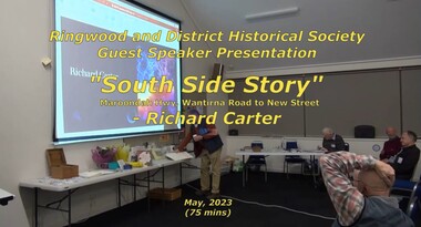
Mixed media - Video, RDHS Guest Speaker Presentation - "South Side Story - Maroondah Hwy, Wantirna Road to New Street" - Richard Carter
Digitised video (3.19GB) Duration: 75 minutes. Recorded May, 2023 (Video is available for viewing at Ringwood & District Historical Society Archives by appointment)Presenter: Past-President of RDHS, Richard Carter, is the guru when it comes to researching properties. South Side Story examines the often forgotten - but important - part of Ringwood from Wantirna Road to Olive Grove on the southern side of Maroondah Highway, Ringwood, Victoria. -
 Melbourne Water
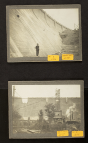
Photographs: The Maroondah Dam Wall Under Construction, 1921-1922
The Maroondah System was first and foremost developed as a functional component of Melbourne's Water Supply System. In addition to functionality, the Melbourne and Metropolitan Board of Works (MMBW) envisioned the Maroondah Reserve to be enjoyed aesthetically and recreationally by the public. This souvenir illustrates the realisation of the Maroondah System as a local recreational and tourist attraction in the early 20th century. The Maroondah Reserve gardens were landscaped with English-style ornamental stonework, exotic trees, flower beds and rose gardens. All features of the water supply system became widely celebrated as beauty spots that continue to be very popular to this day with tourists and locals alike. This souvenir is a product of that flourishing tourist trade. These water supply sites continue to enhance Melbourne’s charm and liveability and are now recognised as places of cultural and historic significanceThese photographs are invaluable in providing insight into many aspects of the Maroondah Reservoir’s early development. The dam wall is a distinctive example of early engineering techniques, with its gravity arch design and concrete construction. The construction of the dam wall represents an important advancement in the technology of dam-building.These images are part of a series of eight photographs which document the construction of the Maroondah Dam in the 1920s.melbourne metropolitan board of works, mmbw, melbourne water, photograph, water, maroondah dam, construction, wall -
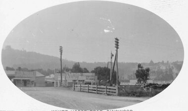
 Ringwood and District Historical Society
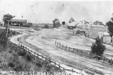
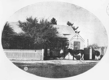
Photograph, Maroondah Highway Central, Ringwood. Whitehorse Road looking west. 1908
Photographs (3 copies- 2 black and white, 1 sepia postcard).Typed below one photograph: "Maroondah Highway Ringwood looking west. Warrandyte Rd coming in from right. 1908." Written on back of another photograph: "Fence divides two levels of road opp Warrandyte Rd looking west. Station Master's house on left." -
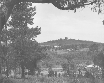 Ringwood and District Historical Society
Photograph, View towards Loughnan's Hill overlooking Maroondah Hwy Ringwood from around Braeside Avenue area
Typed below one photograph, "View towards Loughnan's Hill from Harrison St. 1946". Written below another copy, "Loughnan Hill from Andrew St. 1946". both incorrect - view overlooking Maroondah Hwy from around Braeside Avenue area. -
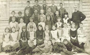 Ringwood and District Historical Society
Photograph, Mr. E. F. Cass and pupils at Ringwood's first school - Cass State School 1451, located at corner Everard Rd. & Maroondah Highway - 1883. Mr. Cass was Head Teacher at the school 1874-1894
Typed below photograph, "Mr. E. F. Cass and pupils at Ringwood's first school, corner Everard Rd. & Maroondah Highway. 1883." Other notes on backing sheets read, "Cass State School 1451, Mr. E. F. Cass (Head teacher 1874-1894)". -
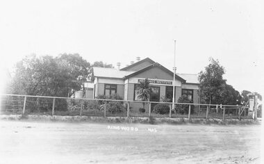 Ringwood and District Historical Society
Photograph, Maroondah Highway Central, Ringwood. Old Mechanics Institute, 1909
Black and white photograph (2 copies- 1 large, 1 small) Typed below large photograph: "Old Mechanics Institute on Maroondah Hwy. Cnr. Melbourne St. - 1919." Written on back of small photograph: "Opened at 4 pm. on 22nd Sept. 1909 by the Premier, the Hon. J. Murray". Stamp indicating that the photograph was produced by "T.R.G.Williams, photographer, Ringwood". -
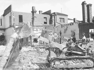 Ringwood and District Historical Society
Photograph, Maroondah Highway Central, Ringwood. Demolition of Coffee Palace, Main St. 1966
Black and white photograph (2 copies- 1 large, 1 small)Typed below large photograph: "Demolition of Coffee Palace - Main St. 1966". Written on back of smaller duplicate photograph: "Demolishing Coffee Palace & shops cnr. Maroondah Hwy. & Adelaide St. (west cnr.) 1966. Portion of house on right - This was home of T. Grant, Blacksmith, 1883". -
 Ringwood and District Historical Society
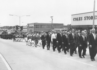
Photograph, Ringwood Clocktower re-opening ceremony march, cnr Maroondah Highway and Wantirna Road, Ringwood, (re-located from previous site at Warrandyte Road), 9/12/1967
Typed below photograph, 'March to new clock tower'. Catalogue card reads, 'Clocktower re-opening. Returned servicemen, Red Cross. Coles Store n/e corner of Maroondah H'way and Ringwood St., S.E.C. State Electricity Office n/w corner H'way and Ringwood St.' -
 Ringwood and District Historical Society
Photograph, Ringwood Post Office in 1908/9. Maroondah Highway
Typed below one copy, "Ringwood Post Office in 1909. Maroondah Highway - Opposite present Holeproof site". Other copy of same photograph reads, "Ringwood original Post Office opposite Guyatts new store - 1908". Backing sheet states, "Ringwood P.O. Weekly Times 4 July 1908". -
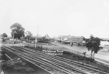
 Ringwood and District Historical Society
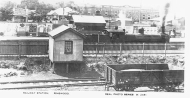
Photograph, Maroondah Highway Central, Ringwood. Railway Station, Ringwood- c1920
Photograph (3 copies- 2 large, 1 small postcard)Typed below large photograph: "Overlooking Ringwood railway station looking north from Station Street. c1920." Inscription beneath photograph reads, "Railway Station. Ringwood. Real Photo Series M. 2451". Image shows steam locomotive in station, with platform advertising boards, and shops fronting Maroondah Highway. -
 Ringwood and District Historical Society
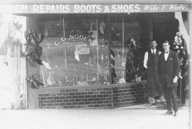
Photograph, Maroondah Highway Central, Ringwood. C.G. Noden Shoe Shop, c1920's
Black and white photograph (2 copies- 1 large, 1 small) Typed below large photograph: "Shoe shop in Maroondah Highway 1920s." Image shows 2 men standing in doorway of shop. Writing on window reads, "C.G. Noden, returned soldier." Included with photograph is a copy of Australian Military Forces enlistment details for Charles George Noden dated 20/8/14. -
 Ringwood and District Historical Society
Photograph, Maroondah Highway Central, Ringwood. Railway Crossing running diagonally from Adelaide St to Bedford Rd- 1918
Black and white photograph (3 copies- 2 large, 1 small Postcard) looking across a railway crossing. (1 small photograph and 3 enlargements). Looking across to Bedford Rd, circa 1910, John Parker, JB McAlpin, Loughan hill in background, 1 original, 3 copiesTyped below one large copy: "Looking across old railway crossing from Station St. to shops on Maroondah Hwy which are now Safeway site. Warrandyte Rd. to right - 1918". Typed below other large copy: "Railway Crossing. Ran diagonally from Adelaide St. to Bedford Rd. - 1918". -
 Ringwood and District Historical Society
Photograph, Maroondah Highway Central, Ringwood. Main St, looking west showing old railway crossing and station masters home in centre - 1918
Black and white photograph (2 copies)Typed below one copy: "Main St. Looking west showing old railway crossing and station masters home in centre - 1918". Typed below other copy: "Maroondah Highway looking west c1918. Showing old railway level crossing at left. Station masters residence in centre. Shops to right now Eastland car park." -
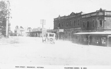 Ringwood and District Historical Society
Photograph, Maroondah Highway Central, Ringwood. Main Street looking west. Adelaide St. corner on right. c1924
Photograph (3 copies- 2 large black and white, 1 sepia postcard) Typed below one of the photographs, "Maroondah Highway looking west. Shops to right now Eastland carpark. Shops in centre are opposite station entrance" Typed below other copy: "Main St. looking west. Adelaide St corner on right. c1924." Typed on sepia postcard copy: "Main Street, Ringwood, Victoria. Valentines Series. M4801." -
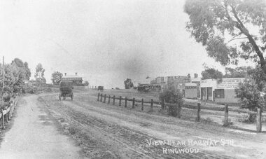 Ringwood and District Historical Society
Photograph, Maroondah Highway Central, Ringwood. Main Street looking west from Warrandyte Road- 1908
Black and white photograph (2 copies)Written in lower right corner of photograph, "View near Railway Stn. Ringwood". Typed below one photograph: "Maroondah Hwy looking towards city with Warrandyte Rd coming in from right. Old Station Master's residence on left. Road had two levels here." Bank is E.S. & A. Agency. Bamford's Timber on right. Station Masters house on left. -
 Ringwood and District Historical Society
Photograph, Maroondah Highway Central, Ringwood. The old Post Office (our third), 1930
Black and white photograph (2 copies)Typed on back of one photograph: "The old Ringwood Post Office (our third) at the corner of Maroondah Highway and Ringwood Street. Ringwood Market is now on the left behind the picket fence and the new telephone exchange is now just past where the picket fence is. Our second telephone exchange was just behind this post office. Note how bare Loughnans Hill was. c 1930s". -
 Ringwood and District Historical Society
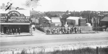
Photograph, Maroondah Highway East, Ringwood- 1920. H.J. Bently, Timber Merchant and Joinery
Black and white photograph (2 copies) Typed below one photograph: "Maroondah Highway 1920. Coffeys now on right and building on left still there (1979)" Written on rear of backing sheet: "Whitehorse Road 1920- Coffeys site- looking north. Shop now rebuilt and occupied by Lawford. Building behind 'H. J. Bentley' sign still there 1976 as part of Lawfords. Matlocks Livery Stables in background to left of 'Lime and Cement' sign. -
 Whitehorse Historical Society Inc.
Article, Guiding the way, 2006
Blackburn South Guides celebrate their 40th Anniversary (photo of District Leader, Susan Errey).Blackburn South Guides celebrate their 40th Anniversary (photo of District Leader, Susan Errey). Book comp. by Anne Taylor, Maroondah Region SecretaryBlackburn South Guides celebrate their 40th Anniversary (photo of District Leader, Susan Errey).errey, susan, girl guides, blackburn south -
Whitehorse Historical Society Inc.
Article, 25th Year Celebrations, 1993
25 Year Celebration of Mitcham based Maroondah Singers, established 1968, in the form of a Concert at Nunawading Arts Centre.25 Year Celebration of Mitcham based Maroondah Singers, established 1968, in the form of a Concert at Nunawading Arts Centre. The Choir commenced through the interest of Mervyn and May Vagg and George Irvine. Guest artists include recipients of the Maroondah Singers Memorial Scholarship (established 1990).25 Year Celebration of Mitcham based Maroondah Singers, established 1968, in the form of a Concert at Nunawading Arts Centre. choirs, maroondah singers, vagg, mervyn, vagg, may, irvine, george, horner, viviene, barnfather, jenny, wishart, claire, morgan, joy, gearing, john, thomson, max -
 Eltham District Historical Society Inc
Photograph, Maroondah System Centenary, Maroondah Dam, 17 Feb 1991, 17/02/1991
Colour photographmaroondah dam, maroondah aqueduct -
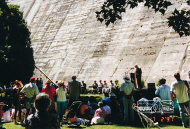
 Eltham District Historical Society Inc
Photograph, Maroondah System Centenary, Maroondah Dam, 17 Feb 1991, 17/02/1991
Colour photographmaroondah aqueduct, maroondah dam -
 Eltham District Historical Society Inc
Photograph, Maroondah System Centenary, Maroondah Dam, 17 Feb 1991, 17/02/1991
Colour photographmaroondah aqueduct, maroondah dam