Showing 2377 items
matching melbourne street plan
-
 Greensborough Historical Society
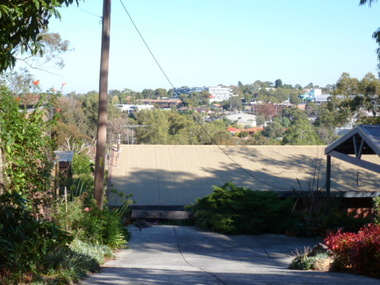
Photograph - Digital image, View of Greensborough from Delfin Crescent, 02/05/2013
This photograph of Greensborough was taken from Delfin Crescent in 2013 to show changes over 40 years, based on Ron Reynold’s sketches in the 1973 publication “Greensborough and Greenhills” published by Cypress Books. Delphin Crescent [previously known as Medhurst Street] was created about 1970 in association with the Delfin Building Company. It was at this time also, that major works on Diamond Creek Road raised the level of the road facilitating the connection of Delfin Crescent with Diamond Creek Road. [Note: 'Medhurst Street was only listed on planning maps pre 1950 when the 'street' had no residents or development.]Digital copy of colour photograph.greensborough and greenhills -
 Greensborough Historical Society
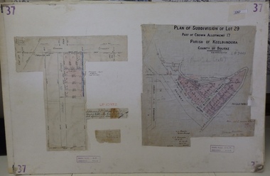
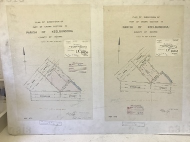
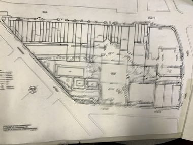
Planning Document, Subdivision Plan # 37. Poulter Avenue and Bicton Street; and, Adeline Street and Grimshaw Street Greensborough, 1971_
Plan of subdivision Lot 29, Part of Crown Allotment, Parish of Keelbundoora, County of Bourke. Poulter Avenue and Bicton Street; and, Adeline Street and Grimshaw Street.An example of hard copy subdivision plans from the Greensborough area. Mainly from the Shire of Diamond Valley era (1964-1994).Plan (2 sheets) mounted on heavy card. subdivision plans, grimshaw street, poulter avenue, adeline street -
 Greensborough Historical Society
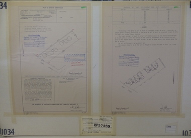
Planning Document, Subdivision Plan #1034. 50 Hume Street, 03/02/1982
Plan of Strata Subdivision at 50 Hume Street Greensborough for 7 units.An example of hard copy subdivision plans from the Greensborough area. Mainly from the Shire of Diamond Valley era (1964-1994).Plan (2 sheets) mounted on heavy card.Stamped and handwritten Council permissions, dates and other details.subdivision plan -
 Greensborough Historical Society
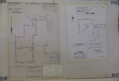
Planning Document, Subdivision Plan #1041. Elder Street Greensborough, 20/04/1983
Plan of Consolidation of Allotments 3 and 4 Brixton Avenue and Plan of Subdivision for Elder Street. An example of hard copy subdivision plans from the Greensborough area. Mainly from the Shire of Diamond Valley era (1964-1994).Plan (2 sheets) mounted on heavy card.Stamped and handwritten Council permissions, dates and other details.subdivision plans, elder street, brixton avenue -
 Greensborough Historical Society
Newspaper clipping, Not safe to station it here, 17/06/2015
Ambulance Victoria's plans to build a new station at Trist Street Watsonia North are to be reviewed, following residents' objections.News clipping, black text, colour image.ambulance victoria, trist street watsonia north -
 Greensborough Historical Society
Newspaper clipping, Building height set to be reduced by developers, 17/06/2015
A proposed development at 4-6 Flintoff Street is to have its plans amended to reduce the height of the building.News clipping, black text.flintoff street greensborough, town planning, banyule city council -
 Greensborough Historical Society
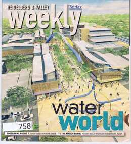
Newspaper, Fairfax Media, Heidelberg and Valley Weekly. August 29 2006, 29/08/2006
This issue of the Heidelberg and Valley Weekly, (August 29 2006) includes a double page feature on the planned redevelopment of the Greensborough Town Centre.55 pages, colour images and black text. greensborough town centre, main street greensborough -
 Greensborough Historical Society
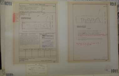
Planning document, Subdivision Plan #1011. Corner Mountainview Road and Hume Streets, 1981_
Plan of Strata Subdivision for units at corner of Mountainview Road and Hume Street Briar Hill.An example of hard copy subdivision plans from the Greensborough area. Mainly from the Shire of Diamond Valley era (1964-1994).Plan (2 sheets) mounted on heavy card.Stamped and handwritten Council permissions, dates and other details.subdivision plans, mountainview road, hume street -
 Greensborough Historical Society
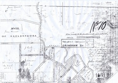
Planning Document, City of Heidelberg, Subdivision Plan # G313, Corner Main and Grimshaw Streets, Greensborough, 08/03/1960
Plan of Subdivision at corner of Main and Grimshaw Streets, Greensborough.An example of hard copy subdivision plans from the Greensborough area. Mainly from the Shire of Diamond Valley era (1964-1994).Plan (2 sheets) mounted on heavy card.Stamped and handwritten Council permissions, dates and other details.subdivision plans, main street greensborough, grimshaw street greensborough -
 Greensborough Historical Society
Map, City of Heidelberg, Subdivision plan of Greensborough, 1965c
Subdivision plan of Greensborough including Briar Hill and Greenhills. Supplied by Bill Cecil whose parents owned the Greensborough Post Office and it is assumed that these maps were used by Bill (who delivered the post on horseback) to keep up to date with the growing number of new streets and housing in Greensborough.Copies of subdivision plan for Greensboroughgreensborough, briar hill, greenhills -
![Document, Town Planning Appeals Tribunal, Town Planning Appeals Tribunal report 1978 [Loyola College], 06/11/1978](/media/collectors/4f729f5697f83e03086015b8/items/58bbb237d0cdef1bcc864955/item-media/58bbb35fd0cdef1bcc8683be/item-fit-380x285.jpg) Greensborough Historical Society
Greensborough Historical SocietyDocument, Town Planning Appeals Tribunal, Town Planning Appeals Tribunal report 1978 [Loyola College], 06/11/1978
Report on an appeal against two conditions on the development of land in Grimshaw Street Watsonia for a secondary school [Loyola College].This document demonstrates some of the problems associated with setting up a school in a residential area.3 pages, torn and yellowed.loyola college -
 Greensborough Historical Society
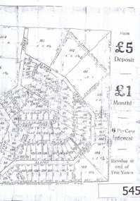
Advertisement, Greenhills Estate, 1923c
The advertisement was used to sell land in the Greenhills area.The plan included details the original street lay out and names applied to them. It also has dimensions of all the blocks of land available and locations and dimensions of easements.A 2 page A3 photoccopy of a real estate advertisement. Nilgreehills, subdivision plan, greensborough -
![Planning Document, Plan of proposed subdivision of land in Greensborough [Map shows Scotland house], 01/04/1971](/media/collectors/4f729f5697f83e03086015b8/items/5982a68921ea6b1420e4e560/item-media/59916fb521ea681094908d7a/item-fit-380x285.jpg) Greensborough Historical Society
Greensborough Historical SocietyPlanning Document, Plan of proposed subdivision of land in Greensborough [Map shows Scotland house], 01/04/1971
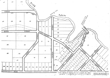
This subdivision of Greensborough shows the home of John Scotland (died 1888) and surrounding area bounded by Hailes, William, Lorimer, and Jessop Streets.Photocopy of plan, 2 pages.Part of plan (68G) of proposed subdivision of Greensborough, part of Crown Portion 18, Parish pf Keelbundora. Scale: 132 ft. to an inchjohn scotland, hailes street greensborough, william street greensborough, lorimer street greensborough, jessop street greensborough -
 Greensborough Historical Society
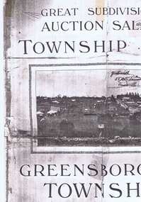
Plan, Greensborough Township Estate, 01/09/1923
Sub-division into 129 lots of land belonging to the Scotland Family, bounded by William Street, Eliza Street, James (Jessop) Street and south of Lorimer Street. Auction 1 September 1923Photocopy, double-sidedsubdivision plans, greensborough township estate, scotland family -
 Greensborough Historical Society
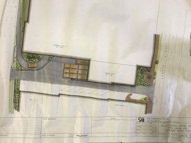
Plan, TTM Consulting, Valley Central Shopping Centre, Myer Loading Area, 1993_11
Plan for the pavement finishes at the Myer loading area at Valley Central Shopping Centre (now Greensborough Plaza) between The Circuit and Church Street.Plan of loading dock showing pavement finishes. Colour and black ink on white paper.greensborough plaza, the circuit greensborough, church street greensborough -
 Greensborough Historical Society
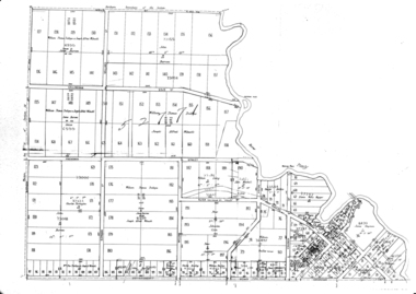
Map, Green's subdivision of Greensborough, 1860c
This map shows the original subdivision of Greensborough by Edward Bernard Green. Some street names are different to today. This map shows the plan on which the town of Greensborough was based.Copy of early map showing subdivision of Greensborough. Black ink on white paper.edward bernard green, greensborough -
 Greensborough Historical Society
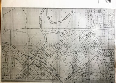
Planning Document, Banyule City Council, Site plan of Greensborough 1997, 28/07/1997
Site plans for the area bounded by Flintoff Street; Grimshaw Street; Main Street and Para Road Greensborough. these plans show the area before the development of Watermarc.This plan shows central Greensborough before the Watermarc developmentSet of 8 site plansgreensborough, greensborough swimming pool -
 Greensborough Historical Society
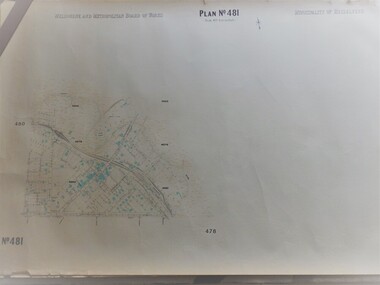
Map, Melbourne & Metropolitan Board of Works, MMBW Plan No.481, 23/09/1949
MMBW plan of part of central Greensborough, Main Street and surrounds, from sports ovals in North to Grimshaw Street in South.Map shows buildings and topography for the area.MMBW plan, black and colour ink on beige parchment, 2 copies."Scale:160 feet to 1 inch"melbourne and metropolitan board of works, mmbw, greensborough -
 Greensborough Historical Society
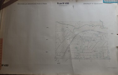
Map, Melbourne & Metropolitan Board of Works, MMBW Plan No.480, 17/10/1949
MMBW plan of part of central Greensborough, from Plenty River in North to Grimshaw Street in South, Sellars Street in West to Kerr Street in East.Map shows buildings and topography for the area.MMBW plan, black and colour ink on beige parchment, 4 copies."Scale:160 feet to 1 inch"melbourne and metropolitan board of works, mmbw, greensborough -
 Greensborough Historical Society
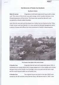
Article, Norm Colvin, My memories of Poulter Ave residents, by Norm Colvin, 28/07/2016
Details of the development and occupation of sites in Poulter Avenue and Bicton Street Greensborough, compiled by resident Norm Colvin.12 pages, text, black and white photographs and colour subdivision plan.poulter avenue greensborough, bicton street greensborough -
 Greensborough Historical Society
Maps, Greensborough. Parish Plan 1860, 1860c
This plan show Green's subdivision of Greensborough, north of Grimshaw Street.Enlargements of Parish plan circa 1860?One copy possibly from 1860, containing lot numbers for a government road, now Main Street, and surrounding streets.greensborough, grimshaw street greensborough, edward bernard green -
 Greensborough Historical Society
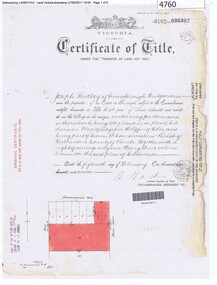
Certificate of Title, Certificate of Title Vol. 3182 Fol. 302, 15/02/1907
Title in the name of Joseph Laidlay of Greensborough, fruitgrower, 14 acres being Lots 7, 8 and 22 on Plan of subdivision 4759, part of Crown portion 17, Parish of Keelbundora County of Bourke, dated 15th February 1907. Northern boundary Greensborough (now Grimshaw) Road, Eastern boundary Henry Street.1 p. colour copy of Titlegreensborough, grimshaw street greensborough, henry street greensborough, joseph laidlay -
 Greensborough Historical Society
Plan, Parish Plan Map of Land North of Grimshaw Street, 11/12/1879
Part of Parish plan of land north of Grimshaw Street bounded by the Plenty River. Includes annotation signed by John Scotland and J. W. Britnell, dated Dec. 11th 1879.Photocopy of part of Parish plan of land north of Grimshaw Street bounded by the Plenty River. Includes annotation signed by John Scotland and J. W. Britnell, dated Dec. 11th 1879greensborough, grimshaw street greensborough, jonah britnell, john scotland -
 Glenelg Shire Council Cultural Collection
Book, Benedict, What To Do At Weddings, c. 1951
Small booklet, a guide for brides, grooms and others involved in wedding planning. Grey card cover, red and navy print. -
 Glenelg Shire Council Cultural Collection
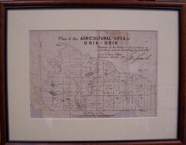
Map - Map of Drik-Drik, 1865
Displayed at History House.Print of map pasted onto board, mounted and framed under glass. Buff-coloured mount. Mahogany stained moulded wood frame, black inner frame.Front: Plan of the Agricultural Area of Drik-Drik L.2556/Prepared by the Board of Lands and Works in accordance with the "Amending Land Act 1865". Lands and Survey Office, Melbourne 11th May 1865. (printed, upper centre). Back: Duncan Hedditchmap, drik drik, plan, geography, cartography -
 Eltham District Historical Society Inc
Photograph, Old Bridge, Kaylock's Crossing, Brougham Street, Eltham, c.1895
Brougham Street was created in Josiah Holloway's 1851 subdivision of Little Eltham. It was one of several east-west streets shown on the subdivision plan as crossing the Diamond Creek. The western part was named Wellington Street on the subdivision plan but was later changed to conform with the name of the eastern part as acknowledgement of the continuity of the street. It is not known when the first bridge was constructed in Brougham Street however it was certainly mentioned at Council’s meeting of 2 June 1884 as being in a dangerous state of repair. This photo (c.1895) of an old bridge shows a very low-level simple log girder bridge crossing the creek at a right angle and so the approaches involved bends in the road alignment. This bridge was generally known as Kaylocks Bridge or Kaylock’s Crossing after the owner of the adjoining land. It was most likely built from around the mid-1850s, or a crossing of some fashion established as Richard George Kaylock, butcher of Little Eltham and his wife Emily Ann settled there in 1854. His property was in Wellington Street (now Brougham Street) and apparently extended across the Diamond Creek. The land on the western side of the creek was farmed, the house being on the eastern side. Kaylock's Bridge formed part of the original coach road to Eltham and in 1922 was described as an "old rustic bridge". Its low level and insubstantial construction made it susceptible to flood damage, necessitating frequent closures until repairs could be carried out. In September 1922, Council called for tenders for a new timber bridge to be constructed at Kaylock’s crossing. An engineering assessment carried out for the Council by Macleod Consulting at the time of the replacement suggested that the construction details indicate that it was in the 1900s, however this dating could possibly have been the result of numerous repairs undertaken over the years to flood damage. The tender was awarded to Mr Weller of Kangaroo Ground who commenced work in February 1923 on a higher-level timber trestle bridge. Work was slowed due to illness of the contractor and the accidental death of a man in March 1923 following the collapse of the bank after he had jumped into a hole that had just been blasted. The bridge was completed around July 1923 at which point the old structure was pulled up, marking what was described in the ‘Advertiser’ newspaper as the passing of an old and well-loved landmark in the district. In April 1924 the approach to Kaylocks bridge was washed away during the heavy flooding that destroyed the Main Road bridge. The western side was repaired, and an extra span was added to the eastern side using timber from the destroyed Main Road bridge. The bridge was again severely damaged four months later in August 1924 When a lack of finances delayed repairs to the Bridge Street bridge in 1931 (also referred to as Obelisk Bridge at the time), traffic had to detour via Brougham Street for some time. Local residents feared that the Bridge Street bridge might never reopen. Kaylocks Bridge was constantly subject to damage by floods. In the 1934 flood it was submerged by two feet of water. In more recent times the bridge was again severely damaged by flooding and repairs made. A new bridge and adjoining footbridge were constructed in 2009. Part of a slide show presentation "Bridges & Waterways of the Shire" by Russell Yeoman to the 13 September 1989 Society meeting. The presentation included slides of historic photos from the Shire of Eltham Pioneers collections as well as several recent views.Photo of earliest known crossing of the Diamond Creek at brougham StreetPostcard photo printbrougham street, eltham, wellington street, kaylocks bridge, bridge, diamond creek (creek) -
 Victoria Police Museum
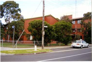
Police Stations (Altona North)
Altona North is a suburb of Melbourne, Victoria, Australia, 10 km south-west of Melbourne's Central Business District, located within the City of Hobsons Bay local government area. Altona North Police Station opened on 7 October 1979 as a new twenty-four police station and was the District Headquarters of Altona District. It comprised a C.I.B. and a Community Policing Squad. It is located at 72 Cooper Avenue, on the corner of McArthurs Road. A new police station is being planned for Galvin Street, opening in 2020.2 colour photospolice stations; altona north police station -
 Victoria Police Museum
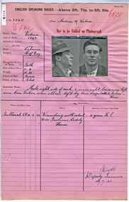
Prison record (Andrew Watson), 22 July 1921
Andrew Reeves was charged in June 1920 with attempting to murder Gertrude Clara Sexton by shooting her and then attempting to commit suicide by shooting himself. Watson was a partner in Mr Sexton's farm at Turriff in the Mallee. Watson and Mrs Sexton were planning to run away together. Prison record for Andrew R. Watson, prisoner registered number 35611, giving details of the prisoner, his crimes and the dates and places of his trials.english speaking prisoner, andrew reeves watson, wounding with intent, attempted murder -
 Eltham District Historical Society Inc
Negative - Photograph, Eltham War Memorial Obelisk 1914-1918, cnr. Main Road and Bridge Street, c.1925
Located on what was referred to as Obelisk Corner, improvements have been been made since the unveiling in August 1919 with the provision of a stone retaining wall topped with a chain link and granite stone boundary, most likely in conjunction with improvements to the intersection into Main Road. Along with the use of the name Obelisk Corner, the Bridge Street bridge was also known as Obelisk Bridge. The Eltham Obelisk was originally located at the corner of Bridge and Main Roads in 1919. In 1943 (WW2) the local community commenced plans to establish the Eltham War Memorial, a living memorial to benefit the children as opposed to a one in stone as per the obelisk. The Eltham War Memorial Trust was established in 1945. In 1947 the Trust intended for the Obelisk to be relocated from Bridge Street and Main Road to the Garden of Remembrance which was planned as part of the Baby Health Centre which was to be the first of three buildings of the Eltham War Memorial to be built in 1951. In 1951 the Eltham RSL was invited to be represented on the Eltham War Memorial Trust. Around this time, with pending roadworks, the obelisk was relocated to the front garden of the Eltham RSL sub branch on Main Road for safe keeping. In 2007, a suggestion was proposed by Harry Gilham (President, EDHS) to John Cohen (ERSL) to claim a special site along with the historic Shillinglaw trees on the now vacant former Eltham Shire Office site adjacent to the Eltham War Memorial precinct for relocation of the obelisk. In 2010 following the financial collapse and sale of the Eltham RSL Sub-Branch property and amalgamation with the Montmorency Eltham RSL sub-branch, the location of the obelisk was again in immediate jepoardy and in conjunction with Nillumbik Shire Council, the obelisk was relocated in front of the Eltham War Memorial buildings in preparation for the Dawn Service on Anzac Day 2012.This photo forms part of a collection of photographs gathered by the Shire of Eltham for their centenary project book,"Pioneers and Painters: 100 years of the Shire of Eltham" by Alan Marshall (1971). The collection of over 500 images is held in partnership between Eltham District Historical Society and Yarra Plenty Regional Library (Eltham Library) and is now formally known as the 'The Shire of Eltham Pioneers Photograph Collection.' It is significant in being the first community sourced collection representing the places and people of the Shire's first one hundred years.Digital image 4 x 5 inch B&W Negsepp, shire of eltham pioneers photograph collection, eltham, main road, eltham war memorial, bridge street, obelisk, obelisk corner -
 Eltham District Historical Society Inc
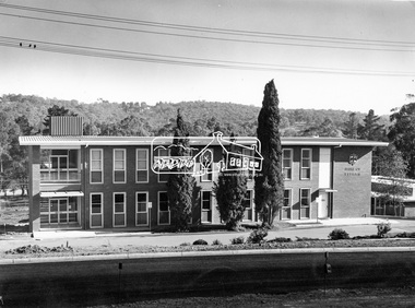
Photograph, Eltham Shire Office, shortly after duplication of Main Road, c.1968
Eltham Shire Council office built 1964 on the former site of Shillinglaw Cottage. In 1971 the offices were extended with a southern wing (to the left of the building) which housed the Eltham Library and planning offices. Taken shortly after widening of Main Road between Pitt Street and Elsa Court which was undertaken between February 1968 and August 1968. Image was most probably commissioned by Eltham Shire Council and taken by Hugh Fisher, photographer who operated from premises between Arthur and Dudely streets and was often contracted by the shire for official photographic work. The image was used in the August 1971 issue of Australian Municipal Journal This photo forms part of a collection of photographs gathered by the Shire of Eltham for their centenary project book,"Pioneers and Painters: 100 years of the Shire of Eltham" by Alan Marshall (1971). The collection of over 500 images is held in partnership between Eltham District Historical Society and Yarra Plenty Regional Library (Eltham Library) and is now formally known as the 'Shire of Eltham Pioneers Photograph Collection'. It is significant in being the first community sourced collection representing the places and people of the Shire's first one hundred years.Digital image and 120 format B&W negativesepp, shire of eltham pioneers photograph collection, eltham, main road, duplication, road widening, shillinglaw trees, local government