Showing 631 items
matching mine shafts
-
 Bendigo Historical Society Inc.
Document - DEVONSHIRE MINES - NOTES ON THE DEVONSHIRE GROUP OF MINES
Carbon copy of notes on the Devonshire Group of Mines - New Chum Line. Notes mention mines, years of operating, location in relation to other mines in the group, yields, dividends and depth of shafts. Some give locations in relationship to streets, etc. Signed by A. Richardson.mine, gold, devonshire mines, devonshire mines, new chum line, surprise, victorian st. mungo, mystery co., duke of edinburgh, gt ext'd st devonshire, new st mungo, duchess tribute, extended south devonshire, south devonshire, devonshire sands cyaniding coy, duchess of edinburgh, albert's coy, old albert's shaft, united devonshire, freeman & coy, the danes, west united devonshire, hopewell, phoenix, extended st mungo, princess alexandra, saxon & celt coys, east devonshire, sheepshead line, new st mungo east shaft, gt. extended hustlers -
 Bendigo Historical Society Inc.
Map - DEVONSHIRE MINES - MAP WITH UNITED DEVONSHIRE & PRINCESS ALEXNDRA (ALEXANDRA)
Hand drawn map taken from Caleb Thomas Plan, Sheet 774 (No ?1) 4/12/1885. Map shows shaft No 18 (Princess Alexndra [Alexandra], Lease No 4567) and shaft No 19 (United Devonshire) depths of some of the levels and geological information. Two mismatched pieces of drafting sheet stuck together with sticky tape and staples.mine, gold, devonshire mines, devonshire mines, united devonshire, princess alexndra, caleb thomas plan -
 Bendigo Historical Society Inc.
Document - DUCHESS OF EDINBURGH - NOTES ON DUCHESS OF EDINBURGH
Hand written notes:- Duchess of Edinburgh. New Chum L/R. Reference: M. D. Depth of shaft - 830 feet. Working - 1874 - 1903. Same grou;nd as Albert & Coy.mine, gold, duchess of edinburgh, duchess of edinburgh, new chum l/r, albert & coy. -
 Bendigo Historical Society Inc.
Document - DON SHAFT - NOTES ON THE DON SHAFT
... Inc. History House 11 Mackenzie Street Bendigo goldfields MINE ...Hand written notes on the Don Shaft situated approximately 14 chains north of the junction of Specimen Hill and Marong Roads. Notes include dates and depth of shaft, shere x cuts were driven and gold returns.mine, gold, don shaft, don shaft, notes on the don shaft, gold returns -
 Bendigo Historical Society Inc.
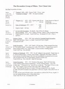
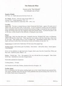
Document - DEBORAH MINE - NOTES ON THE DEBORAH MINE
One hand written notes, one typed and three carbon copies of notes on the Deborah Mine. Notes include depth of shaft, locality, plant, engine house, winding engine, boilers, crushing battery, earlier plant, prominence, best gold, gold yield and dividends. References: Mines Dept. Booklet Bendigo Goldfield 1936, Mines Dept. Quarterly and Annual Reports and A. Richardson.mine, gold, deborah mine, deborah mine, notes on the deborah mine, mines dept. booklet bendigo goldfield 1936, mines dept quarterly and annual reports, a. richardson -
 Bendigo Historical Society Inc.
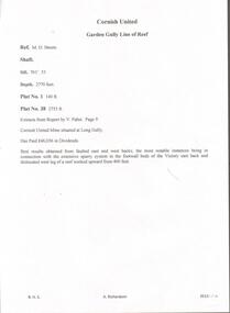
Document - CORNISH UNITED MINE - EXTRACTS FROM REPORT BY V PABST
Hand written notes from a report by V. Pabst. Notes include depth of shaft, depth of Plat Nos 1 & 38, locality, Dividends paid and the best places where gold was found. Victory also mentioned.mine, gold, cornish united mine, cornish united mine, extracts from report by v. pabst, dividends paid, v. pabst, victory -
 Bendigo Historical Society Inc.
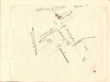
Document - COLLMAN & TACCHE - MAP
Hand drawn map on heavyweight decorated graph paper. Map has parts of Mt. Korong Rd. and Dowding St. drawn in. Broken line drawn from Lansells C & T to Iron Pin. Further away another line drawn from C & T Main Shaft to a point 67 ft 10 in. away, then 78 ft 10 in away, then another point 60 ft 3.5 in away. No date on drawing. Drawn on decorated graph paper, Lawson Series printed by Lawson & Bray (Sales) 58 Margaret Street, Sydney.mine, gold, collman & tacche, collman & tacche, map, lansells c & t, mt korong rd, dowding st. -
 Bendigo Historical Society Inc.
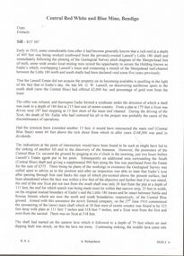
Document - CENTRAL RED, WHITE AND BLUE MINE - NOTES ON THE CENTRAL RED, WHITE AND BLUE MINE
Seven pages of hand written notes on the Central Red, White and Blue Mine. Information on how the mine was obtained and geological information. Initialled AR.mine, gold, central red, white and blue mine, central red, white and blue mine, notes on the central red, white and blue mine, lansell's little 180, eadie's, sheepshead reef, mr g w lansell, central blue, cr t c pryor, delbridge (manning's) shaft, garden gully line, hustlers line, ar -
 Bendigo Historical Society Inc.
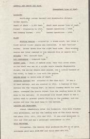
Document - CENTRAL RED, WHITE AND BLUE MINE - LOCALITY AND PLANT OF THE CENTRAL RED, WHITE AND BLUE MINE
... Sheepshead Line of Reef Flying Fox Delbridge or Mannings Shaft Mines ...Three typed copies of notes on the Central Red, White and Blue Mine. Notes give locality, plant, gold produced and where the gold was obtained from. One copy has 'Typed at Mines Dept' written at the top and has a correction in the locality area. It is signed by A Richardson.mine, gold, central red, white and blue mine, central red, white and blue mine, locality and plant of the central red, white and blue mine, sheepshead line of reef, flying fox, delbridge or mannings shaft, mines dept. booklet 'bendigo goldfield' 1936, annals of bendigo mining sections 1910 - 1936, a richardson -
Bendigo Historical Society Inc.
Document - CENTRAL RED, WHITE AND BLUE MINE - LOCALITY AND DESCRIPTION OF THE CENTRAL RED, WHITE AND BLUE MINE
... or Mannings Shaft Mine's Dep't Booklet 'Bendigo Goldfield' Geo Brown ...Hand written notes on the Central Red, White and Blue Mine. Notes include depth of Shaft, when formed, locality, plant, poppet legs, engine house, crushing battery, gold produced and the reef the gold was obtained from. Also includes references.mine, gold, central red, white and blue mine, central red, white and blue mine, locality and description of the central red. white and blue mine, sheepshead line of reef, new chum hill, delbridge or mannings shaft, mine's dep't booklet 'bendigo goldfield' geo brown 1936, annals of bendigo1910 to 1936, a richardson -
 Bendigo Historical Society Inc.
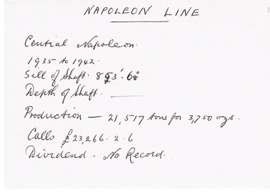
Document - CENTRAL NAPOLEON MINE - NOTES ON CENTRAL NAPOLEON MINE
Hand written notes on cream paper. Years from 1935 to1942. Lists the Sill of Shaft depth, Production and Calls.mine, gold, central napoleon mine, central napoleon mine, napoleon line -
 Bendigo Historical Society Inc.
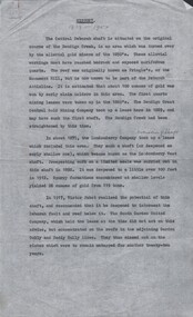
Document - CENTRAL DEBORAH GOLD MINE - HISTORY OF CENTRAL DEBORAH GOLD MINE 1939 - 1954
4 typed pages of the history of the Central Deborah Gold Mine from 1939 to 1954. Mentions the start of mining at this site and Victor Pabst, who in 1917 recommended that the shaft be deepened. His advice was not acted on for another twenty-two years. Also mentioned is the geology and Method of Mining.mine, gold, central deborah gold mine, central deborah gold mine, history of central deborah gold mine, geology of the central deborah gold mine, method of mining -
 Bendigo Historical Society Inc.
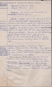
Document - CENTRAL DEBORAH GOLD MINE - NOTES ON CENTRAL DEBORAH GOLD MINE
2 copies of notes on the Central Deborah Gold Mine, 1 hand written and 1 carbon copy. Notes include Locality, the Shaft and it's depth, the Original Shaft and a Winding Engine which had been at several other sites.mine, gold, central deborah gold mine, central deborah gold mine, notes on central deborah gold mine, winding engine, roberts & sons, new chum goldfields, new golden fleece, deborah -
 Bendigo Historical Society Inc.
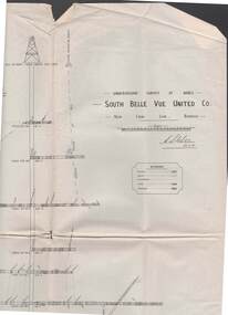
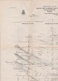
Map - STRUGNELL COLLECTION: UNDERGROUND SURVEY OF MINES, BENDIGO, 29-3-01
Map, Underground Survey of Mines, Bendigo, South Belle Vue United Co.,New Chum Line.Transverse Section. Signed H.S.Whitelaw29.3.01 Drawing appears to show samples of connecting horizontal shafts with their respective mineral contentsH.S.Whitelawmap, bendigo, south belle vue united co.. -
 Bendigo Historical Society Inc.
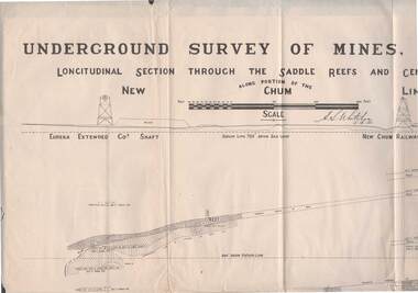
Map - STRUGNELL COLLECTION: NEW CHUM LINE OF REEF, 5/4/01
Map, Along portion of the New Chum Line, Underground Survey of Mines, Bendigo, Longitudinal Section through the Saddle Reefs and Centre Country. Eureka Extended Co's shaft, New Chum Railway Co's shaft. Surveyed under the supervision of H.Herman, B.C.E., F.G.S., Acting Government Geologist.H.S.Whitelowmap, bendigo, new chum line -
 Bendigo Historical Society Inc.
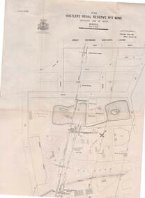
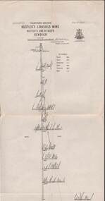
Map - STRUGNELL COLLECTION: HUSTLER'S LINE OF REEFS, BENDIGO, September 1913
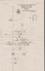
Map, Hustler's Line of Reefs, Hustler's Royal Reserve No. 2 Mine, Bendigo.Plate No. V (5).. Great Extended Hustler's Lease, Imperial Hustler's, Hustler's Royal Reserve No. 2 Park & Main Shafts, Fortuna Hustler's Lease.Bulletin No 33 Signed H.A.Whitelaw Underground survey Office Bendigo September 1913Underground Survey Office, Bendigo.map, bendigo, hustler's royal reserve no. 2 mine* -
 Bendigo Historical Society Inc.
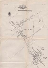
Map - STRUGNELL COLLECTION: HUSTLER'S LINE OF REEFS, BENDIGO, September 1913
Map, Hustler's Line of Reefs, Comet Mine, Bendigo Plan.Plate No.XX1V (24). Map, Bulletin No 33 Signed H.A.Whitelaw Underground survey Office Bendigo September 1913 Drawing shows upper and lower levels and appears to show samples of connecting horizontal shafts with their respective mineral contentsUnderground Survey Office, Bendigo.map, bendigo, comet mine -
 Bendigo Historical Society Inc.
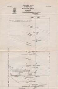
Map - STRUGNELL COLLECTION: HUSTLER'S LINE OF REEFS, BENDIGO, September 1913
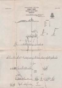
Map, Hustler's Line of Reefs, Comet Mine, Longitudinal Section.Plate No.XXV1 (26).Bulletin No 33 Signed H.A.Whitelaw Underground survey Office Bendigo September 1913 Drawing shows the vertical shaft descending to over 1692 feetUnderground Survey Office, Bendigo.map, bendigo, comet mine -
 Bendigo Historical Society Inc.
Map - STRUGNELL COLLECTION: HUSTLER'S LINE OF REEFS, BENDIGO, September 1913
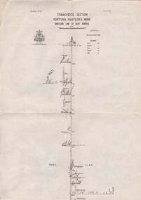
Map, Hustler's Line of Reefs, Comet Mine, Transverse Section, Plate No.XXV (25). Bulletin No 33 Signed H.A.Whitelaw. Drawing shows the vertical shaft descending to over 1692 feet and appears to show samples of connecting horizontal shafts with their respective mineral contentsUnderground Survey Office, Bendigo.map, bendigo, comet mine -
 Bendigo Historical Society Inc.
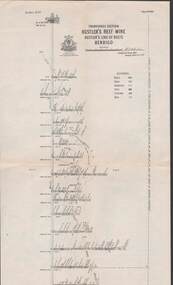
Map - STRUGNELL COLLECTION: HUSTLER'S LINE OF REEFS, BENDIGO, September 1913
Map, Hustler's Line of Reefs, Hustler's Reef Mine, East & West Cross-Cuts, North & South of Shaft. Plate No. X1X (19).Bulletin No 33 Signed H.A.Whitelaw. Drawing shows the vertical shaft descending to over 1296 feet and appears to show samples of connecting horizontal shafts with their respective mineral contentsUnderground Survey Office, Bendigo.map, bendigo, hustler's reef mine -
 Bendigo Historical Society Inc.
Map - STRUGNELL COLLECTION: HUSTLER'S LINE OF REEFS, BENDIGO, September 1913
Map, Hustler's Line of Reefs, Fortuna Hustler's Mine, Bendigo, Transverse Section. Plate Mo.111(3).Bulletin No 33 Signed H.A.Whitelaw. Drawing shows the vertical shaft descending to over 2228 feet and appears to show samples of connecting horizontal shafts with their respective mineral contentsUnderground Survey Office, Bendigo.map, bendigo, fortuna hustler's mine -
 Bendigo Historical Society Inc.
Map - STRUGNELL COLLECTION: HUSTLER'S LINE OF REEF, BENDIGO
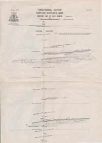
Map, Hustler's Line of Reef, Bendigo, Fortuna Hustler's Mine, Longitudinal Section. Plate No. 1V (4). NOTE--- Plates 4,8,13,29,26 & 31 form a Longitudinal Section from Fortuna Hustler's to Hustler's Consols Mine.Bulletin No 33 Signed H.A.Whitelaw. Drawing shows the vertical shaft descending to over 2228 feetUnderground Survey Office, Bendigo.map, bendigo, fortuna hustler's mine -
 Bendigo Historical Society Inc.
Map - STRUGNELL COLLECTION: HUSTLER'S LINE OF REEFS, September 1913
Map, Hustler's Line of Reefs, Hustler's Consols Mine, Transverse Section, Bendigo.Plate no. XXX111 (33).Bulletin No 33 Signed H.A.Whitelaw. Drawing shows the vertical shaft descending to over 1326 feet and appears to show samples of connecting horizontal shafts with their respective mineral contentsUnderground Survey Office, Bendigo.map, bendigo, hustler's consols mine -
 Bendigo Historical Society Inc.
Map - HUSTLER'S LINE OF REEFS, September 1913
Map, Hustler's Line of Reefs, Hustler's Reef & Hustler's Reef No. ! Mines, Bendigo, Longitudinal Section,Plate No.XX (20). NOTE-- Plates 4,8,13,20,26 & 31 form a Logitudinal Section from Fortuna Hustler's to Hustler's Consols Mine.Bulletin No 33 Signed H.A.Whitelaw. Drawing shows the vertical shaft descending to over 1601 feetUnderground Survey Office, Bendigo,map, bendigo, hustler's reef & hustler's reef 1 -
 Bendigo Historical Society Inc.
Map - STRUGNELL COLLECTION: HUSTLER'S LINE OF REEFS, September 1913
Map, Hustler's Line of Reefs, Hustler's Reef Mine, Transverse Section, Bendigo. Plate No. XV111 (18).Bulletin No 33 Signed, H.A.Whitelaw. Drawing shows the vertical shaft descending to over 2195 feet and appears to show samples of connecting horizontal shafts with their respective mineral contentsUnderground Survey Office, Bendigo.map, bendigo, hustler's reef mine -
 Bendigo Historical Society Inc.
Map - STRUGNELL COLLECTION: HUSTLER'S LINE OF REEF'S. HUSTLER'S REEF NO.1 MINE, September 1913
Map, Hustler's Line of Reefs, Hustler's Reef No. 1, Bendigo, East & West Cross-cuts, North & South of Shaft, Plate No.XX11 (22). Bulletin No 33 Signed H.A.Whitelaw. Drawing shows the vertical shaft descending to over 1229 feet and appears to show samples of connecting horizontal shafts with their respective mineral contentsUnderground Survey Office, Bendigo.map, bendigo, hustler's reef no.1 mine -
 Bendigo Historical Society Inc.
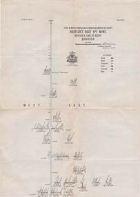
Map - STRUGNELL COLLECTION: HUSTLER'S LINE OF REEFS, September 1913
Map, Hustler's Line of Reefs, Hustler's Reef & Hustler's Reef No.1 Mines Plan.Plate No. XV1.(16) Sheet 2 .Bulletin No 33 Signed H.A.Whitelaw.Underground Survey Office, Bendigo, September,1913. Included is the emblem of the Geological Survey of Victoria. Drawing shows a plan view of reefs and shaft locations .Underground Survey Office, Bendigomap, bendigo, hustler's reef & hustler's reef 1 -
 Bendigo Historical Society Inc.
Map - STRUGNELL COLLECTION: HUSTLER'S LINE OF REEFS, September 1913
Map, Hustler's Line of Reefs, Hustler's Reef No.1 Mine Bendigo, Transverse Section.Plate No. XX1 (21).Bulletin No 33 Signed H.A.Whitelaw. Drawing shows the vertical shaft descending to over 1428 feet and appears to show samples of connecting horizontal shafts with their respective mineral contentsUnderground Survey Office, Bendigo.map, bendigo, hustler's reef no.1 mine -
 Bendigo Historical Society Inc.
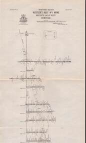
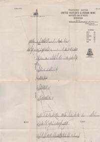
Map - STRUGNELL COLLECTION: UNITED HUSTLER'S & REDAN MINE, September 1913
Map, United Hustler's & Redan Mine, Transverse Section, Hustler's Line of Reefs, Bendigo. Plate No. XX1X (29).Bulletin No 33 Signed H.A.Whitelaw. Drawing shows the vertical shaft descending to over 1805 feet and appears to show samples of connecting horizontal shafts with their respective mineral contents. One level shows respective water levels .Underground Survey Officemap, bendigo, hustler's & redan mine -
 Bendigo Historical Society Inc.
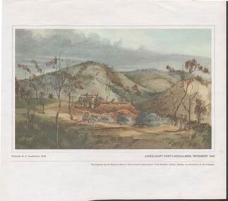
Painting - CAROL HOLSWORTH COLLECTION: 1970 NATIONAL BANK PAINTING 'UPPER SHAFT - PORT LINCOLN MINE 1848'
... 'UPPER SHAFT - PORT LINCOLN MINE 1848'...1970 NATIONAL BANK PAINTING REPRODUCTION Upper Shaft , Port... REPRODUCTION Upper Shaft , Port Lincoln Mine 1848 possibly painted ...1970 NATIONAL BANK PAINTING REPRODUCTION Upper Shaft , Port Lincoln Mine 1848 possibly painted by W.A. Cawthorne 1848 Below the picture title the words - Reproduced by the National Bank in 1970 from the watercolour in the Mitchell Library , Sydney , by permission of the Trustees.The centre of the picture shows mine workings four or five men are shown in the picture the rest of the area is undevelopedpainting, watercolour, gold diggers