Showing 344 items matching "mount clear"
-
 Warrnambool and District Historical Society Inc.
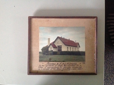
Photograph, South Warrnambool School, framed
The South Warrnambool Primary school No 1902 was opened in 1877 by the mayor at the time Cr J Cramond. The first teacher was Mrs Eliza Clarke. It catered for the children of the strong and closely knit community of South Warrnambool. The Mc Donald family was one of these families. A clear photograph of a school with which many past students would have fond memories. A contribution over 25 years to a primary school in this case by W D McDonald is a story of personal endeavour. It therefore has historical and social significance.Coloured photograph of the South Warrnambool State School framed with inscription written in black ink at bottom of coffee coloured mount.Presented to Mr W D McDonald by the residents of South Warrnambool as a token of appreciation for services rendered as a member of the School Committee (1912-1937) A Wilkins Photo. Stuart Mc Donald and Shirley written on back of frame mounting board.south warrnambool primary school, school number 1902, warrnambool history -
 Linton and District Historical Society Inc
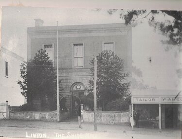
Photograph, Shire of Grenville Hall and Angus Shop, Sussex Street, Linton
Shire of Grenville Hall and Angus shop, Sussex Street, Linton. Dating the photograph: The photograph can be dated to after 1887, when John Angus purchased the shop building (originally owned by Thomas Austin) from B. N. Dodd. 'W. Angus': From 1887 until the late 1890s the shop was run by John Angus' wife Wilhelmina Angus, who often advertised her business in the local newspaper, the 'Grenville Standard' (see photograph of advertisement, Registration no. 2019-346). It is not known when Mrs Angus retired, but it is understood that her son William then took over the shop. Elsie Jennings, an Angus descendant, recalled in a letter to LDHS that her uncle had run a draper's shop at this site. (See letter in "Linton - Township History - Recollections and reminiscences' file.) It is not clear whether the "W. Angus" in the sign refers to Wilhelmina Angus or to William Angus.Enlarged black and white copy of original photograph, which has been mounted on white card. The photograph shows a two-storey brick building, and next to it a double-fronted shop. The two-storey building is the original Grenville Shire Hall, built in the mid 1860s. The fence outside it is being used to post notices. Two large pine trees are between the fence and the building. The smaller shop next to the hall has a verandah supported by round timber posts, and signs across the front of the verandah read "Tailor" and "W. Angus". Two men engaged in conversation with each other are standing to the left under the verandah. There is a flagpole attached to one of the gate posts of the hall, and there is a telegraph pole in the street in front of the hall.w. angus, william angus, wilhelmina angus (née statemann), buildings, shire of grenville hall, shops, shire hall, town hall -
 Department of Energy, Environment and Climate Action
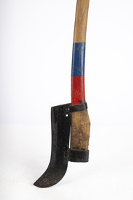
Equipment - Heavy brush cutter: American 'True Temper'
Used to clear scrub and undergrowth.Heavy brush cutter (American 'Bush Hook') Single edge, eye and strap mounted on axe handle. Colour on handle indicates FCV district ownershipforests commission victoria (fcv), hand tools -
 Flagstaff Hill Maritime Museum and Village
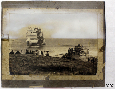
Photograph - Vessel, Sailing Ship, Original image taken between 14 November 1908 and early January 1909
The photograph was taken towards the ESE from Peterborough headland. It reproduces an original landscape view of the FALLS OF HALLADALE shipwreck which occurred at 3 am on 14 November 1908 (and confirms that the vessel was on an ENE tack at the time of the collision). The image includes three groups of formally dressed Edwardian sightseers on the cliff top and an adjacent rock ledge. Subsequent versions of this well-known image are usually cropped to present a striking portrait view, emphasising the vertical lines of the ship’s masts and sails, and excluding the groups of sightseers on the right hand of the original image. The small girl in the foreground and the loose sail on the foremast are common to both the landscape and edited portrait versions of this memorable scene. The photograph was taken at an early stage of the ship’s final days, somewhere between the date of her grounding in mid-November 1908 and early January 1909 (when salvagers began dynamiting her iron masts so they could get to the valuable cargo still in her holds). Firmly wedged between two parts of the reef and with all of her square-rigged sails fully set, the FALLS OF HALLADALE provided a spectacle for many miles along the coast. Over these weeks she attracted hundreds of sightseers, and photographers, before the pounding seas finally broke her weakened hull and she disappeared back into deeper waters. The iron-hulled, four-masted barque, the Falls of Halladale, was a bulk carrier of general cargo. She left New York in August 1908 on her way to Melbourne and Sydney. In her hold, along with 56,763 tiles of unusual beautiful green American slates (roofing tiles), 5,673 coils of barbed wire, 600 stoves, 500 sewing machines, 6500 gallons of oil, 14400 gallons of benzene, and many other manufactured items, were 117 cases of crockery and glassware. Three months later and close to her destination, a navigational error caused the Falls of Halladale to be wrecked on a reef off the Peterborough headland at 3 am on the morning of the 15th of November, 1908. The captain and 29 crew members all survived, but her valuable cargo was largely lost, despite two salvage attempts in 1908-09 and 1910. ABOUT THE ‘FALLS OF HALLADALE’ (1886 - 1908) Built: in1886 by Russell & Co., Greenock shipyards, River Clyde, Scotland, UK. The company was founded in 1870 (or 1873) as a partnership between Joseph Russell (1834-1917), Anderson Rodger and William Todd Lithgow. During the period 1882-92 Russell & Co., they standardised designs, which sped up their building process so much that they were able to build 271 ships over that time. In 1886 they introduced a 3000 ton class of sailing vessel with auxiliary engines and brace halyard winches. In 1890 they broke the world output record. Owner: Falls Line, Wright, Breakenridge & Co, 111 Union Street, Glasgow, Scotland. Configuration: Four masted sailing ship; iron-hulled barque; iron masts, wire rigging, fore & aft lifting bridges. Size: Length 83.87m x Breadth 12.6m x Depth 7.23m, Gross tonnage 2085 ton Wrecked: the night of 14th November 1908, Curdies Inlet, Peterborough south west Victoria Crew: 29The shipwreck of the FALLS OF HALLADALE is of state significance: Victorian Heritage Register No. S255. The Falls of Halladale shipwreck is listed on the Victorian Heritage Register (No. S255). She was one of the last ships to sail the Trade Routes. She is one of the first vessels to have fore and aft lifting bridges. She is an example of the remains of an International Cargo Ship and also represents aspects of Victoria’s shipping industry. The wreck is protected as a Historic Shipwreck under the Commonwealth Historic Shipwrecks Act (1976). The Falls of Halladale shipwreck is listed on the Victorian Heritage Register (No. S255). She was one of the last ships to sail the Trade Routes. She is one of the first vessels to have fore and aft lifting bridges. She is an example of the remains of an International Cargo Ship and also represents aspects of Victoria’s shipping industry. The wreck is protected as a Historic Shipwreck under the Commonwealth Historic Shipwrecks Act (1976).Photograph; sepia-toned black and white, mounted on grey card. Image of a fully rigged sship, the Falls of Halladale, stranded near the shore with a group of people in the foreground seated on the ground. The photograph is well-worn. Description of Image: Quadrant 01, vessel with full set of sails perched on reef with stern submerged; Quadrant 02, predominantly clear sky over flat calm sea; Quadrant 03, two groups of standing sightseers on rocky promontory with three individuals approaching from left foreground; Quadrant 04, fifteen well-dressed sightseers seated on grassed cliff top including one child and six women. There is a deliberately obscured inscription in white ink along the lower border or foreground of the photograph.Lettering of white uppercase in grassed foreground of initial image is smudged out by subsequent development process and largely indecipherable. However pencilled writing on rear of card ― “Mrs Francis” and “Wreck of ‘Falls of Halladale’ Peterborough 1908”.flagstaff hill maritime village, shipwreck coast, peterborough reef, shipwreck photograph, falls of halladale, warrnambool, flagstaff hill, shipwrecked image, flagstaff hill maritime museum, shipwrecked coast, maritime museum, edwardian sightseers, shipwreck spectacle, photograph, mrs francis, wreck of falls of halladale, peterborough 1908, 1908, peterorough, shipwreck -
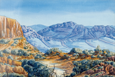 Glenelg Shire Council Cultural Collection
Painting - Watercolour, Gerhard Inkamala, Untitled (Landscape), n.d
Western Aranda artist, Gerhard Inkamala. Born in 1917, Gerhard was the nephew of Albert Namatjira and grew up being inspired by his artwork and the surrounding landscapes. He became a skilled artist and during the 1940s was one of the founders of the famous Hermannsburg School of Art. In the 1950s Gerhard and his brother Adolf were included in a group exhibition in Alice Springs at the home of Rex Battarbee who was the Warrnambool-born art teacher of Albert Namatjira. He died in 1977.A landscape scene showing the Australian outback. Trees and shrubs in the foreground with rocky hills in the background. The foreground is an ochre/orange colour and the hills and rocks in the background are a blue/grey colour. The sky is clear and blue. Signed bottom right. The work is mounted on cream mountboard and framed in a white timber frame under glass.'Gerhard Inkamala' signed bottom right hand side of the painting. -
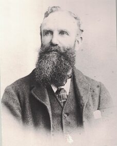 Linton and District Historical Society Inc
Photograph, Samuel Lewers
The subject is identified in the early LDHS index to photographs as Samuel Lewers. It is not clear whether this means the Samuel Lewers who was the first manager of the Bank of New South Wales in Linton, or his son Samuel, who was granted a soldier-settler block at Mannibadar after World War I.Enlarged black and white copy of original photograph, mounted on card. The photograph is a head and shoulders portrait of a man with a moustache and beard, who is wearing a jacket (with handkerchief in pocket), buttoned vest, white shirt, and tie or cravat. -
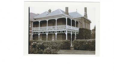 Buninyong & District Historical Society
Photograph - Mount Buninyong Homestead front view, View showing part of the homestead of Mount Buninyong Homestead taken by an unknown photographer in 1991, 1991
House built by the Sott Family in 1884.Good condition, showing clear details of the buildingNonehistoric homestead, scott family, scotsburn. -
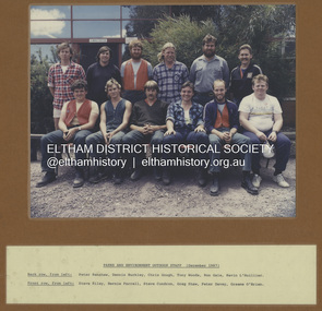 Eltham District Historical Society Inc
Photograph - Colour Print, Eltham Shire Council, Parks and Environment Outdoor Staff, December 1987
Back row, from left: Peter Renshaw, Dennis Buckley, Chris Gough, Tony Woods, Ron Gale, Kevin L'Huillier Front row, from left: Steve Riley, Bernie Farrell, Steve Condron , Greg Shaw, Peter Davey, Graeme O'Brien See also SEA_01-591bernie farrell, chris gough, council staff, dennis buckley, eltham shire council, graeme o'brien, greg shaw, kevin l'huillier, parks and environment, peter davey, peter renshaw, ron gale, staff, steve condron, steve riley, tony woods -
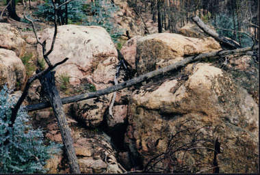 Wooragee Landcare Group
Photograph, circa April 2003
This is a photograph taken in the Chiltern - Mount Pilot National Park near Chiltern in Victoria. On this day, the Wooragee Landcare Group was in the national park looking for signs of the tiger quoll. Tiger quolls can be found in few places with the Chiltern - Mount Pilot National Park being one of them. This photograph is of a tiger quoll nesting site as tiger quolls often nest between large rocks. This image also shows the damage caused by the 2003 bushfires. These bushfires happened at the same time as the 2003 Alpine bushfires. This bushfire started by lightning and quickly became the largest fire in Victoria since the 1939 Black Friday bushfires. The Alpine bushfires destroyed 1.3 million hectares and burnt for 59 days before it could be controlled. The 2003 bushfires severely damaged the environment and concern was raised about the safety of tiger quoll. This photograph displays how the nesting site was damaged by the fire. This meant that the quoll itself could have also been impacted by the fire. Hence why the Wooragee Landcare group went for a search for signs of the quoll.This photograph is significant because it shows a tiger quoll nesting site. Tiger quolls are a highly valuable species because they live in very few places. This, in turn, makes their nesting site valuable. This photograph also signifies the impact of the 2003 bushfires on the Chiltern - Mount Pilot National Park. The image displays burnt trees which makes it clear that the fire was deeply damaging. The fallen log over the nesting site demonstrates how the bushfire must of put the tiger quolls at risk because of how the fire damaged their nesting site. Landscape coloured photograph printed on gloss paperReverse: WAN NA 0ANA0N0 NNN+ 1 1636 / [PRINTED] (No.9) / 923bushfires, mount pilot chiltern national park, mount pilot, chiltern, victoria, wooragee landcare group, wooragee landcare, wooragee, national park, tiger quoll, 2003 bushfires, beechworth, rocks, nesting site, photograph, 2003 alpine bushfires, 1939 black friday, 2003, hectares, fire, damage, burnt, burn -
 Box Hill Historical Society
Photograph - P Bird's timber merchant
P Bird's timber merchant brick premises established 1918 and original building with staff lined on the street.Sepia photo mounted on cardboardHandwritten family history of original donor "Ruby Sweetland daughter of Frederick & Emma Sweetland Hay N.S.W./ granddaughter James & Mary Ann Adelaide Collier, Box Hill./ now wife of Alexander Thomas Gunn of Hepburn Springs Vic 1976/Mary Ann Adelaide Collier nee Britnell, was born on way out/to Australia in the St. Vincent Gulf in a sailing boat near Adelaide/ Sth Australia, hence the name of Adelaide/ Alexander Thomas Gunn's grandfather owned the No 1 Country Hotel Licence at Kangaroo Flat "The Glasgow Arms/Hotel. near Bendigo Victoria, about 1840./ They had a family of 6 boys & 5 girls/4 boys Tom, Dan, Jack & Alexander took up land in Thorpedale/ Victoria about 1860 & paid 1 [pound] an acre for it. This land was covered/ in dense forest fern tree & fern gullies & would rain for 6 months/ in this district was the tallest tree in the world height 365 feet./ Palling splitting was main source of living for many years after being/ cleared now produces the best potatoes in Victoria. Very pretty hilly country"bird's timber yard, businesses, bird> p., timber yards, timber merchants, employees -
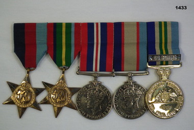 Bendigo Military Museum
Award - MEDAL SET WW2, Post 1945
Allan Maxwell BULL initially enlisted in the CMF on 18.6.1941 No V48765 age 20 years. Posted to 266 LAD on 17.11.1941 AEME, transfers to the 2nd AIF 16.9.1942 No VX115965, embarks for New Guinea 10.3.1943, hospital 21.12.1943 with Diarrhoea, rejoins unit 6.1.1944, embarks and arrives Australia 20.2.1944, transfer to Amenities Services 9.2.1944 then to 1st Aust Cinema unit, promoted Cpl 29.1.1945, embarks for Morotai 12.4.1945 then to North Borneo 21.6.1945. Although not clear it appears he arrived back in Aust on 11.1946 and was discharged from the Army on 30.1.1946.Medal set, brass plate mounted, set of (5) re A.M.BULL. 1. 1939-45 Star. 2. Pacific Star. 3. War Medal 1939-45. 4. Australian Service Medal 1939 - 45. 5. Australian Service Medal 1945-75 with clasp "SW Pacific""VX115965 A.M.Bull"decorations, medals, service awards -
 Eltham District Historical Society Inc
Albert Jones, Chute Street, Diamomnd Creek, c.1920
Reproduced in The Diamond Valley Story, Dianne H Edwards, The Shire of Diamond Valley 1979, p43 "1920s - the toiwnship now has some private phones. To the right at the single pole in Main Street is of Diamond Creek's street lamps. Rose's bakery is at the rear of the corner house. The baker's daughty, Fanny, married Charlie Wilson. Both attended Diamond Creek State School in the 1890s. The small square hgouse on the left-hand sid in Inglis Street was the home of the Kidd family. This house and the station are the only buildings in the photo still standing [1979]. Above and to the right of the Kidd hoime is the Diamond Creek Cool Stores, built in 1913 and now the site of the squash courts. The hills around Perversi Street are cleared and planted ith orchards. On the corner of Chute and Diamond Streets is the roof of the Lawrey sisters haberdashery shop. Photo: Spark/Jones Collection"Stamped in purple ink on reverse within border "A.J. SPARK COLLECTION PHOTOS 1900 - 1930 PHOTOGHRAPHER LATE ALBERT JONES DIAMOND VALLEY. TEL: 83-3561"a.j. spark collection, albert jones, chute street, diamond creek, j. mcritchie, royal mail hotel -
 Federation University Historical Collection
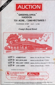
Document - Real Estate Flyers, J. Chatham, Daunt Pty. Ltd, Various years
The Ballarat-based firm, J Chatham and Co, serviced the Hotel Industry in Victoria, particularly Victoria’s Wimmera and Western Districts. Established by Jack { John} Chatham in 1956, The business was based at 7 Lydiard St South, Ballarat. As a regional hotel and motel broking specialist, Jack worked closely with other Ballarat businesses, including the Ballarat Brewery. On Jack's death in 1967, the business was taken over by his son, Philip, and renamed J Chatham Pty Ltd. The business continued to grow. Chatham House, the building the business operated from, and subsequently purchased and named, at 7 Lydiard St South, Ballarat still stands today. It was renamed by new owners in 2025 In the 1970's Philip opened a Melbourne branch in Dudley St, Nth Melbourne, The Melbourne branch, J Chatham and Daunt Pty Ltd, operated from 205 Victoria Parade, Fitzroy, a few blocks west of the Carlton United Brewery in the 1980s. In the late 1980s Philip's son, Andrew, joined the business, then called J Chatham, Daunt and Foley Pty Ltd. The business at this time operated from a terrace house [?Bouverie Street] Carlton near Grattan St. By 2005, the Daunt and Foley partnership had dissolved. In 2001 Philip predeceased his wife, Elizabeth Chatham (nee Holmes), a Director of the Company. His share of the business was inherited by Andrew. Elizabeth died in 2005. The business was sold in 2006. [Jane Dyer (nee Chatham).16 June 2024]Thirty-one real estate flyers j chatham, daunt, auction, "greenslopes" haddon, "mindai park" cape clear, kingston district, the mill restaurant malmsbury, "emu downs" beaufort, "wattlw grove" mount mercer, "rowan lodge", centennial hotel kensington, "ben nevis estate" elmhurst, "paddlesteamer lodge" wodonga place albury, "woodlands" ararat, lake wallace hotel, edenhope, cremorne hotel newtown geelong, terang hotel, avoca hotel, woori yallock hotel, ballarat tram family restaurant, victoria hotel woodend, patersons siding restaurant and bar, ballarat, the coorrabin motor inn, stawell, clifton hill hotel, clifton hill, albion hotel, kyabram, "stag hotel" learmonth, "osborne" rokewood, shamrock hotel echuca, willaura hotel, willaura, "boggy creek pub" curdie vale, shamrock hotel, dennington, "mt elephant hotel/motel" derrinallum, narmbool, ballarat, brighton inn hotel, khyat's, posters, real estate, hotels., restaurants -
 Federation University Historical Collection
Book, Final recommendations Ballarat Study Area Land Conservation Council, Victoria, 1982, 1982
... pine plantations langi ghiran state park mount buangor state ...Yellow soft covered report of 95 pages . The contents of the report include: Parks, reference areas, wildlife reserves, water production, hardwood production, softwood production, flora Reserves and Flora and Fauna reserves, bushland reserves, historic area and reserves, rivers and streams, Roadside conservation and Highway parks, Education areas and School Plantations, Lake Reserves, geological reserves, recreation, scenic reserves, agriculture, mineral and stone production, utilities and survey, township land, Uncommitted Land, military training, other reserves and public land. Maps include: The Study area 1: 250 000 Supplementary Mapsland conservation authority, ballarat, endowment plantations, pine plantations, langi ghiran state park, mount buangor state park, enfield state park, ballarat-creswick regional park, rossbridge, black lake, flax mill swamp, dereel lagoon, lake bolac, lake wongan, langi ghiran reservoir, gong gong reservoir, pincotts reservoir, beales reservoir, wilsons reservoir, moorabool reservoir, korweinguboora, korweinguborra reservoir, learmonth bores, sago hill, illabarook reservoir, ballarat water commission, dunneworthy, mount cole, mont lonarch, ben major, waterloo, trawalla, linton, ross creek, canadian, shepherds flat, lal lal, mount doran, raglan, chute, carngham, buninyong, watsons hill, enfield, cape clear, illabrook, rokewood junction, mount warrenheip, nerrina, jubilee, golden stream, australasian deep lead mine, happy valley school, piggoreet, berringa, bulldog, ballarat common, wildlife, water, timber, flora, rivers, geology, agriculture, warrenheip, biodiversity