Showing 445 items matching "north to victoria hill."
-
 Bendigo Historical Society Inc.
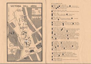
Map - VICTORIA HILL AREA
Map of Victoria Hill Area printed on yellow paper. Details of tracks, cuttings, contours (in Metres) and Anticline. Location of mines, open cuts and buildings are shown. Numbers on map are: Ballerstedt's Claim 1 - 5; North Old Chum Co. 6; Lansell's 180, 7,8,11; Battery 9.10.12; Victoria Quartz Co. 13 - 17; Rae's Open Cut and Vicinity 18 - 28, Great Central Victoria Co 29 - 36, Adventure and Advance Area and vicinity 37 - 40 and Victoria Consols Co 41.map, bendigo, victoria hill, victoria hill area, victoria consols, new chum anticline, great central victoria, rae's open cut, w rae's home, victoria quartz, ballerstedt's open cut, lansell's 180, north old chum, central nell gwynne, john brown factory, gold mines hotel, cleopatra needle type chimney, floyd's battery, ballerstedt's 24yd claim, humboldt shaft, wittscheibe's jeweller's shop, luffsman and sterry's claim, victoria hill reserve, mines dept reervation -
 Bendigo Historical Society Inc.
Audio - Making Tracks, c1980s
Bendigo Workshops is a railway workshop in Bendigo, Victoria, Australia. It is located in the north of the city beside the junction of the Swan Hill and Deniliquin railway lines. The site covers 10.3 hectares of land and has 31 separate buildings, including a 10,000 sqm main workshop building and six kms of railway track. The workshops were opened in November 1917 by the Victorian Railways. It opened in response to political pressures from provincial groups for decentralization, with the Victorian Railways preferring the cheaper option of expanding the existing Newport Workshops in suburban Melbourne. The 1980s were a time of restructuring, and on the breakup of the Victorian Railways the workshops passed to the State Transport Authority and then the Public Transport Corporation.Three Audio Files - by David Bennet, Davis Moon and Kevin Whelan who worked at the Bendigo Railway Workshops. The three share their working life memories history, bendigo, bendigo railway workshops -
 Bendigo Historical Society Inc.
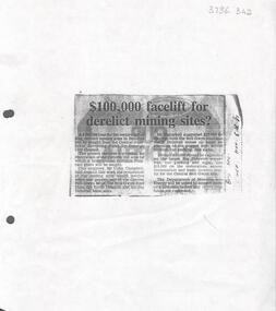
Newspaper - Kangaroo Flat Gold Mine Collection: Article, Facelift for Derelict Mining Sites, 6th November 1985
Newspaper article, (photocopied onto A4 paper) Bendigo Advertiser November 6th, 1985, headed '£100,000 facelift for derelict mining sites?' Article describes how the Bendigo Council were seeking a loan from the Goldfields Revolving Fund for the restoration of the Victoria Hill area and for the restoration of the relics and poppet legs of the Central Nell Gwynne, the Nell Gwynne Reef Mine, the North Deborah and the Big Deborah Mine sites.Written in black pen on right hand side: B'go Adv. Nov. 6th. '85gold mining, nell gwynne mine, north deborah mine, big deborah mine, poppet legs, bendigo, restoration -
 Ballarat Tramway Museum
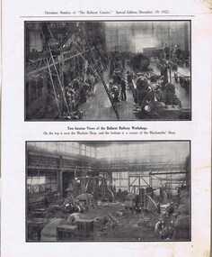
Newspaper, The Courier Ballarat, The Courier, Christmas Number, 1922, Special Issue, Dec. 1922
Yields information about Ballarat, it businesses, identifies and its locations or environs through photos and advertisements and articles.The body of the "Christmas Number of the Ballarat Courier, Special Edition - December 1922" = coves missing. See attached listing with worksheet for summary of contents. Contains many advertisement for local business houses, photos and fiction and articles , pages 3 - 94 still existing, stapled. Notes on contents of Christmas Number of The Ballarat Courier Special edition, December 19, 1922. Photos Ballarat Association Cricket Team, winners Country championship - 1922 and photo of dinner at Sth Melb. Town Hall by VCA. - p83 Ballarat Golf club, Arch of Victoria and Club House - p63, 65 Ballarat Imperial Football club - league premier- 1922 - p19 Ballarat Miners Turf Club - showing stands and office bearers - p43 Ballarat North Golf Club - p67 Ballarat Town hall - p87 Ballarat Turf Club Office bearers and race finish - p45 Ballarat Yacht club - opening day and yacht race - p89 Black Hill Progress Association, - members and scenes - p33 Eureka Monument - p79 Finish of a race at Miners RC - p45 Head of the Lake and St. Patrick's the winning crew - p47 1.ake Wendouree - boating on (Gardens side - p] 1 Lake Wendouree, rowing and club houses - p28 Lal Lal waterfalls - p61 Lydiard St. View - Railway Station, Cemetery gates, Mining Exchange, Post Office and Banks - p71 National Federation Conference - 1922 - p39 South city Football club, Ballarat Assoc. Premiers 1922 - p25 Sturt and Lydiard St - top photo Town Hall and T&G building, with ESCo tram (pencil note "Tram No- 3 - Peckham Truck" written in - p75. Bottom photo, looking south from Town Hall. The Western Oval during a football match - p23 Victorian Farmers Union Conference, Ballarat 1922 - p37 Victorian Railway photos of various scenes around Victoria: Pages 3, 5, 7, 55, 59 Views of Victoria Park - p91 VR Ballarat Railway Workshops - p9 Advertisements on even numbered pages, featuring in particular: Ballarat Motor Garage - with photos - p88 C.A.V. Willard - storage battery service Stn - p76 with photo. CA Mitaxa - Builder - includes photos of new homes - p38 Coles & Pullham - stock sales - with photos - p86 ESCo - p70 Geo E. Dibble, machinery merchant - includes photos - p26 Geo. Waller - asphalt and carrier - photos of work and buildings Hanrahan's of Ballarat - Garage and stables - p30 J.L.Ridings - dentists, - photos of surgery p14 Longhurst's Bakeries - Mair and Yuille St. Includes Photos. - P84 Preston Motors, Melbourne - The Maxwell Sep Morse - Motor and Carriage builders - photo - p78 St. Patrick's College - photos of students and buildings - p46 State Savings Bank of Vic. - p20 T-J. Brown house remover and general carrier, photo of traction engines - p90 T.J.Haymes - Wallpaper etc. - p33 The Ballarat Co-Op Distribution Society - includes photos - p44 The Hupmobile - McLean Richards Motors - p22 Wallace Butter Factor - p82 Articles Black Hill Progress Association - p35 Damaged pages - cut outs clippings etc. Page 17/18 - top half bottom 1/3 of page 21/22 Pages: 9, 70, 71, 75, 87 and 90 imaged. Record reviewed and images of some of the pages added 10-9-2013p74. Note re tram 33.trams, tramways, ballarat, commerce, ballarat business, sports, science, esco -
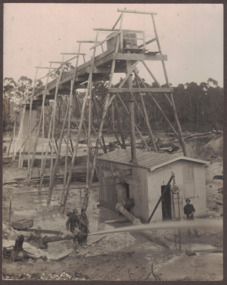
![View of Victoria Hill, Bendigo, taken from Old Chum Hill / [by] Nicholas Caire, circa 1876](/media/collectors/550653872162f11fb04854aa/items/577752a3d0cdd10a5c16e654/item-media/57775308d0cdd10a5c171c46/item-fit-380x285.jpg) Kew Historical Society Inc
Kew Historical Society IncPhotograph, Anglo-Australasian Photographic Company, View of Victoria Hill, Bendigo, taken from Old Chum Hill, c. 1876
Nicholas Caire was born on Guernsey in the Channel Islands in 1837. He arrived in Adelaide with his parents in about 1860. In 1867, following photographic journeys in Gippsland, he opened a studio in Adelaide. From 1870 to 1876 he lived and worked in Talbot in Central Victoria. In 1876 he purchased T. F. Chuck's studios in the Royal Arcade Melbourne. In 1885, following the introduction of dry plate photography, he began a series of landscape series, which were commercially successful. As a photographer, he travelled extensively through Victoria, photographing places few of his contemporaries had previously seen. He died in 1918. Reference: Jack Cato, 'Caire, Nicholas John (1837–1918)', Australian Dictionary of Biography.An original, rare photograph from the series 'Views of Victoria: General Series' by the photographer, Nicholas Caire (1837-1918). The series of 60 photographs that comprise the series was issued c. 1876 and reinforced a neo-Romantic view of the Australian landscape to which a growing nationalist movement would respond. Nicholas Caire was active as a photographer in Australia from 1858 until his death in 1918. His vision of the Australian bush and pioneer life had a counterpart in the works of Henry Lawson and other nationalist poets, authors and painters.Albumen silver photograph on boardprinted in ink on support l.c.: VIEW OF STURT STREET, BALLARAT, TAKEN FROM THE TOWN HALL TOWER. / COPYRIGHT REGISTERED. printed in ink on support reverse c.: VIEWS OF VICTORIA. / (GENERAL SERIES.) / No. 13. / VIEW OF VICTORIA HILL, BENDIGO, TAKEN FROM OLD CHUM HILL. / This scene represents two of the principal Quartz-reef claims in the district of Bendigo, with their surface / excavations. The one nearest the foreground is the North Old Chum's Company's claim, which is very rich with / gold-bearing quartz. The other claim, on the hill side, is the private property of Mr. George Lansell, and is even / more valuable than the former, giving employment to over 100 men. The building on the right is the quartz-crushing / plant belonging to the new Chum and Victoria Companies. The excavations are several hundred feet in depth. printed in ink on support reverse l.c.l.: J.W. FORBES, Agent, printed in ink on support reverse l.c.: ANGLO-AUSTRALASIAN PHOTOGRAPHIC COMPANY, MELBOURNE. printed in ink on support reverse l.c.r.: 10 Temple Court, Collins Street West.nicholas caire (1837-1918), landscape photography, victoria hill - bendigo - victoria -
Stawell Historical Society Inc
Map, Parish of Stawell, North Ward & Big Hill etc
Shows Newington Co, Moonlight Co, St George Co, Victoria Co, Galatea Co Shows Tramline over Big Hill, Leviathan Co, Parish of Stawell, North Ward & Big Hill etcstawell -
 Surrey Hills Historical Society Collection
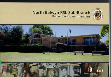
Book, Boroondara City Council, North Balwyn RSL Sub-branch: Remembering our members, 2018
Gives photographs and brief profiles of the RSL members commemorated on the Wall of Remembrance at the North Balwyn RSL Memorial Hall. The building was opened in 1959 and closed in June 2015. The North Balwyn RSL clubrooms were then incorporated into the newly-created Greythorn Community Hub.north balwyn rsl sub-branch (vic), returned services league of australia, greythorn community hub, veterans - victoria- biographies, war memorials, plaques, plaquettes -
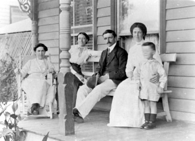 Surrey Hills Historical Society Collection
Photograph, Mr and Mrs P Falconer and son, Ron at Aird family home, 1913
It is identified as the home of J B Aird. The 2 women on the left are not identified. On the right are Mr & Mrs P Falconer and son Ron. Mrs Falconer was nee Aird. Research: 1917 electoral roll lists James Bromich Aird (optician), Sarah Ann Aird (HD) and Hilda Lillian Aird (tailoress) at 'Stratford', Croydon Road, Surrey Hills. Earlier electoral roll lists him in Ringwood and later ones at Wandin North. James Bromich Aird (1854-1938) and Sarah Ann Edwards (1858-1930) had 7 children. Emily Victoria Aird (1884-1957) and Hilda Lillian Aird were 2 of their daughters. Emily married Patrick Henry Falconer (1879-1964). Their son Ronald Keith Falconer (1908-1983) was born and died in Surrey Hills. James and Sarah Aird are buried in Box Hill Cemetery. Given the collecting focus adopted by Jocelyn Hall it can be assumed that this was taken at 'Stratford' in Croydon Road, Surrey Hills. Possible identification of the 2 other women in the photo would be Sarah Aird on the left on the deck chair and Hilda Aird on the bench with the Falconer family.Black and white photo of a family group of 3 women, a man and a young boy on the verandah of an Edwardian timber home. edwardian style, clothing and dress, ronald keith falconer, patrick henry falconer, miss emily victoria aird, mrs emily victoria aird, miss hilda lillian aird, james bromich aird, mrs emily victoria falconer, miss sarah ann edwards, mrs sarah ann aird, stratford, croydon road, box hill cemetery -
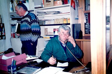 Surrey Hills Historical Society Collection
Photograph, Wally Hoersch of J&V Warren-Smith Auto, 1991
The land along the eastern side of the Union Road shops between Montrose Street and the railway line was originally owned by the Zeplin family. It was subdivided in 1914 and offered for sale as individual sites. Building did not occur until after WW1 and after the creek across Union Road had been barrelled. The photo was taken in the office of the garage which was built at 145 Union Road in 1925. It has had continuous use as a garage since then. Originally there were petrol bowsers on the footpath. The façade of the building is remarkably the same as it was in 1925 when David Denholm was the first proprietor. He remained until c1950 and was followed by Benchley Motors P/L, then Spenden Motors P/L. John and Val Warren-Smith purchased it in c1980. In 2019 their family, including Philip and Glenn Warren-Smith and 2 of Philip's sons, still operate it as J&V Warren-Smith Auto Service. The man on the phone is Walter Kurt (Wally) Hoersch. Warmly regarded and often mistakenly thought to be Philip's father, he was not a member of the family. Wally had an interesting background, not known to many. He was born in the German Templer colony of Sarona in Palestine. It had been established in Ottoman Palestine in 1871 and is now a suburb of Tel Aviv. In July 1941, 188 people from Sarona were deported to Australia on the Queen Elizabeth. Wally's family were amongst them. They were interned in Tatura in Central Victoria until 1947. Wally lived in Mont Albert North and later Templestowe; he died on 21/7/2002.The Union Road shopping strip was assessed for heritage protection by Lovell Chen in June 2011 (Surrey Hills and Canterbury Hill Estate Heritage Study: Union Road Commercial Precinct Citation). Within this report two buildings were mentioned as, unusually, still performing their original role. These were Dartnell’s Pharmacy at 376-378 Canterbury Road (contributory) and the motor garage at 145 Union Road (contributory). This is one of a number of 3 images taken in 1991 which document the interior and function of the building.A colour photo of a man sitting behind a desk in an office on the phone. There is another man standing behind him to his right.john warren-smith, val warren-smith, philip warren-smith, glenn warren-smith, walter hoersch, wally hoersch, j&v warren-smith auto, union road, businesses, garages, benchley motors p/l, spenden motors p/l, -
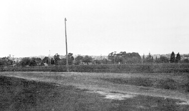 Surrey Hills Historical Society Collection
Photograph, Corner of Braemar and Melrose Streets, Box Hill North
Reproduced by permission of Mr John Arnold from his book: "The Riversdale Golf Club - a history, 1892-1977." Copyright to book: Riversdale Golf Club. Surrey Hills Golf Club operated from 1892-1908 then moved and became Riversdale Golf Club. The game was played across paddocks from Trafalgar Street, Mont Albert to Whitehorse Road and down Victoria Crescent to where Box Hill TAFE is now located in Elgar Road. There were problems with cows eating the tee flags! The clubhouse still exists as 30 Trafalgar Street.Black and white panoramic photo taken from the corner of Braemar and Melrose Streets, Box Hill North. There is a large area of ground in the front. A fence and hedge traverse the photo in the middle distance in front of which is a tall light pole. Behind the hedge mature trees and houses can be made out.Caption: "Bottom: The same view today taken from the corner of Braemar and Melrose Streets, Box Hill North, or, from the position of the threesome to the left in the above photograph." + in grey lead pencil in Jocelyn Hall's hand (No 290)sports grounds, surrey hills golf club, riversdale golf club, melrose street, braemar street, surrey hills, john arnold -
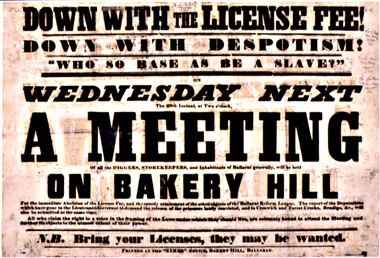 Public Record Office Victoria
Poster, 1854
VA 2825 Attorney-General's Department (previously known as the Law Department)Eureka Stockade:Bakery Hill Meeting Postertrial, bakery hill -
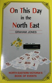 Wodonga & District Historical Society Inc
Book - On This Day in the North East: North Eastern Victoria's Book of Events, Graham Jones, 1989
This publication covers over 1,000 events - the essence of three years of radio scripts broadcast during 1987, 1988 and 1989 on 3NE in the series On This Day in the North East - covering a wide spectrum of activities from grand occasions and important events, to happenings of a less formal nature, from all over the North East - Wangaratta, Benalla, Beechworth, Myrtleford, Bright, Glenrowan, Yarrawonga, Rutherglen-Corowa, Albury-Wodonga, Corryong, Yackandandah, Mansfield, Euroa and districts.non-fictionThis publication covers over 1,000 events - the essence of three years of radio scripts broadcast during 1987, 1988 and 1989 on 3NE in the series On This Day in the North East - covering a wide spectrum of activities from grand occasions and important events, to happenings of a less formal nature, from all over the North East - Wangaratta, Benalla, Beechworth, Myrtleford, Bright, Glenrowan, Yarrawonga, Rutherglen-Corowa, Albury-Wodonga, Corryong, Yackandandah, Mansfield, Euroa and districts.northeast victoria events, radio scripts 3ne, social life northeast victoria -
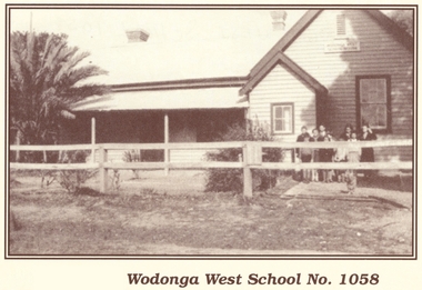 Wodonga & District Historical Society Inc
Photograph - Wodonga West School No. 1058
Wodonga West School opened on 24 January 1870 and closed on 9 May 1950. It was located near the current intersection of McKoy Street and the Hume Freeway in West Wodonga on land donated by J.W. Klinge. The school replaced an older school, “Green Hills School, which was located north of the railway line. A public telephone was installed at the school and the mail service operated from the school three days each week. In 1935 a row of 15 ornamental trees was planted along the boundary fence, one for each of the pupils at the school. When this school closed the nine remaining students were transferred to Wodonga Primary School.This image is significant because it documents the early developments in the provision of education in Wodonga, Victoria A black and white photo of a group of children standing outside the Wodonga West School building.wodonga schools, wodonga west primary school, education wodonga -
 Ballarat Tramway Museum
Slide - Set of 9, Warren Doubleday, Ballarat - last weekday of full operations, 20/8/1971
Photos taken on the last weekday of full operations by the SECV in Ballarat prior to the first closure of the Victoria St line on 22/8/1971. 1 - trams 33, 13, 30, and 12 in the City loop. Has the Dickins food store, Thomas Jewellers, Gear Chemist, Patersons stores in the view. 2 - tram 37 running a Special passing the trams above in the City Loop. Also has the Hartley's and the T& G buildings in the view. 3 - tram 27 descending the Lydiard St hill about to pass the Titanic Bandstand. 4 - tram 35 turns from Sturt St into Lydiard St north with the Town Hall in the background. 5 - tram 27, Victoria St inbound in Wendouree Parade near Haddon St. Has the tram stop shelter in the view. 6 - tram 39 climbing the Lydiard St North hill. 7 - tram 32 in bound in Sturt St west passing a 40mph speed limit sign. 8 - trams 21 and 34 crossing at the Grant St loop on the Mt Pleasant line. 9 - tram 37 inbound in Lydiard St North with the Ballarat Station building in the background and the signal gantry.Yields information about the last full week day of SEC Tramway operations in Ballarat and has a strong association with the archivist. Set of 9 Kodachrome colour slides - cardboard mountsHave the photographer's slide numbers written on them.trams, tramways, closure, sturt st, lydiard st, tram 13, tram 30, tram 12, tram 37, tram 43 -
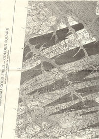 Bendigo Historical Society Inc.
Map - LONG GULLY HISTORY GROUP COLLECTION: BENDIGO GOLD FIELD - GOLDEN SQUARE GEOLOGICAL SURVEY OF VICTORIA
BHS CollectionPart of a map of the Bendigo Gold Field - Golden Square. Geological Survey of Victoria. Shown are reefs, faults and anticlines. Many of the mines are shown on the map. Gullies, hills and streets are also shown.bendigo, history, long gully history group, the long gully history group - bendigo gold field - golden square geological survey of victoria, north bendigo state school reserve, hospital reserve, benevolent asylum reserve, empire hill, richmond hill, raes hill, south end hill, victoria hill, new chum hill, iron bark hill, redan hill, view hill, hustlers hill, camp hill -
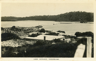 Lakes Entrance Historical Society
Postcard - New Works, Bulmer H D, 1910c
Also second copy same sizeBlack and white postcard showing view of Works buildings and north end of eastern pier. Cunninghame Arm and tip of Bullock Island and groyne work on right. Reeves channel and tip of Rigby Island on left. Mt Barkly and Kalimna Hills in background. Photo taken from top of dune. Roof of Carstairs boarding house centre foreground. Lakes Entrance VictoriaLakes Entrance, Cunninghamewaterways, settlement, historic buildings -
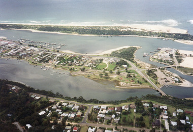 Lakes Entrance Historical Society
Photograph - Lakes Entrance, 1997c
Colour print of aerial view looking south of western side of township. Shows housing on Kalimna Hill, North Arm, part of Bullock Island, Cunninghame Arm, the outer barrier and east pier of man made entrance. Lakes Entrance Victoriawaterways, township -
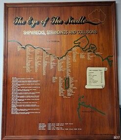 Flagstaff Hill Maritime Museum and Village
Artwork, other - Shipwreck Board, The Eye of the Needle: Shipwrecks, Stranding's and Collisions, ca 2002
The Shipwreck Board is a feature of Flagstaff Hill Maritime Museum and Village/ its subject is explained briefly in the Museum's handbook, The Flagstaff Hill Navigator, published in 2008: - "Known as the ‘Eye of the Needle’ the treacherous entrance to Bass Strait is littered with the wreckage of large international vessels and smaller sail and steam craft used in coastal trade. The vessels bringing emigrants and cargo to Australia found the western entrance to Bass Strait the most dangerous part of their voyage. They had to thread their way between the southern point of Victoria (Cape Otway) and the northern point of King Island, a stretch of water less than 90 km wide. Many smaller coastal vessels were lost at Portland, Port Fairy, Warrnambool and Apollo Bay which are not safe harbours in certain weather conditions. "The Shipwreck Board shows shipwrecks, strandings and collisions which occurred in this area up to the year 1940. Wrecks are identified by a yellow light and collisions/strandings by a green light. These lights also identify the decade the wreck occurred by lighting up when the relevant decade button is pushed. Interesting happenings of the decades are listed next to the buttons." The Shipwreck Board's demonstration of The Eye of the Needle is an interactive visual display that helps teach the perils and dangers faced by early settlers in Victoria. It tells of the vast number of lives lost. It lists the names of many infamous shipwrecks and significant events.The large stained and lacquered timber board is mounted in a timber, frame. It is painted with a small sketch of Australia, and an enlarged outline of the southern coast of Victoria, King Island and the North West coast of Tasmania. The interactive display highlights the shipwrecks, standings and collisions suffered by many vessels as they navigated the 'Eye of the Needle', a narrow stretch of Bass Strait. The locations of the Lighthouses are pinpointed. Lists of groups of ships are below the coastlines. A painted scroll shows eight major shipwrecks with the number of lives lost for each one. A table shows historical facts associated with the decades from pre-1830 to 1940. A system of coloured lights compares the decades with the vessels that suffered damage. The board was created by artist and signwriter, Alex O'Flynn Computer Signs.flagstaff hill, maritime museum, maritime village, shipwreck coast, eye of the needle, shipwreck locations, bass strait, basses strait, king island, north west tasmania, south coast of victoria, cape otway, victorian lighthouse, king island lighthouse, strandings, coastal tracers, emigrant ships, sea trade, 1930s-1940s, shipwreck board, the eye of the needle, collosions, alex o'flynn, alex o’flynn computer signs, shipwrecks of western victoria -
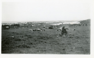
 Lakes Entrance Historical Society
Photograph - Butcher's Paddock, Hanlon, Vera, 1940c
Historic home at 90 Captenter St 'Corrumbene' is pictured on right hand side of photograph. Godsell's house opposite on Western side of North ArmBlack and white photograph showing view of lower reaches of North Arm, part of town, Cunninghame Arm and sand dunes in background, and North Arm on right. Photo taken from Allens Hill, Myer St, vacant paddocks in foreground, known as Butcher's Paddock, slaughterhouse and buildings in mid view. Lakes Entrance Victoriatownship, waterways, animals -
 Lakes Entrance Historical Society
Photograph - Butcher's Paddock, Clark, Ruth, 1945c
Also second print 7 x 11.5Black and white photograph of the North Arm and township, taken from Allens Hill, looking across the Butcher's Paddock. It shows the slaughter house, sheep, lambs and other animals in the paddock. Lakes Entrance Victoriawaterways, topography, township, animals -
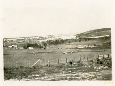
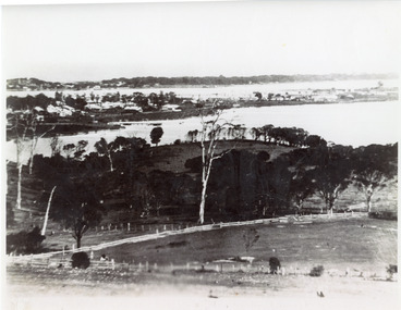 Lakes Entrance Historical Society
Photograph - Lakes Entrance, 1935c
Enlarged from postcard produced for Mrs Allen to advertise Allen's Tearoom at the brow of Myer St hill, known as Allen's Hill to locals.|This is the paired before photograph showing the left hand side on Butchers paddock in the panoramic views, the right hand side number 01715. This photograph used in the 150 year Lakes Entrance 1858-2008 display.Black and white photograph of the township, taken from Allen's Hill, Myer St. It shows the town between Cunninghame Arm and North Arm, cleared and fenced paddocks in foreground, New Works village and sand hummocks in distance. Lakes Entrance Victoria township, waterways, topography -
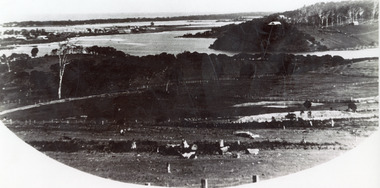 Lakes Entrance Historical Society
Photograph - Allen's Tearoom, 1935c
Enlarged from postcard produced for Mrs Allen to advertise Allens's Tearooms at the brow of Myer St, known as Allen's Hill.Black and white photograph of township, situated between Cunninghame Arm and North Arm. Shows cleared and fenced paddocks on eastern side of North Arm, some clearing and ring barked trees on western side, the high point sometimes referred to as Bernies Point after Bernie Sutherland, who lived and built boats here. Lakes Entrance VictoriaMrs Allens Seaview Cottage Lakes Entrancewaterways, topography, township, tearoom -
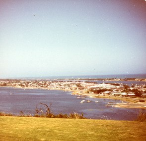 Lakes Entrance Historical Society
Photograph - Lakes Entrance, Fraser, Nancy, 1985c
Colour photograph of a bend in the North Arm. It shows the sports ground, eastern end of town. Jetties and hire boats at edge of lake. Photo taken from cleared hill, Kalimna, in foreground. Bass Strait in distance. Lakes Entrance Victoriawaterways, township -
 Eltham District Historical Society Inc
Photograph - Digital Photograph, Marguerite Marshall, St John's Anglican Church, Diamond Creek, 7 September 2008
The building was designed by Charles Maplestone of Heidelberg, son-in-law to Anthony Beale of St Helena. Maplestone was a prominent architect who came out to Australia with his family in 1852. The foundation stone was laid by Mrs Isabella Maplestone on 11th November 1867. The bricklayers for the church were George Stebbing, H Limmer, H Spicer and a Mr Timm while Thomas Day was the stonemason. Another three years were to pass before sufficient money could be raised for its completion. It was opened by Bishop Perry on 1st November, 1870. The church bell which hung under a tree for 50 years until it was incorporated in the parish hall was brought out from England and presented by Charles Orme. In 1916, the estate of George Martin Pizzey left sufficient money to build the red brick hall, which still stands today (2023) though in January 1969 the hall and bell tower were badly damaged by bushfire. Coincidentally the former home of benefactor, George Pizzey was destroyed in the same fire. Of particular significance are the interior and exterior of the church, the Sunday school and hall with emphasis on pre-World War I fabric (excluding the 1990s additions) and the three coloured glass windows currently suspended in the 1990s entry foyer. In 2011 further alterations were made to the front of the Church. The church is historically significant because it was the oldest public building in the former Diamond Valley Shire, is amongst the oldest buildings in the Shire of Nillumbik and is associated with the early settlement of the Diamond Creek district. The church is historically, socially and spiritually significant because it has been a place of worship for over 150 years and continues to be, an important meeting place in the Shire. The church is aesthetically significant for the three stained glass windows executed by the noted stained glass manufacturers, Ferguson & Urie, as well as the supporting coloured glass windows in the church. The Sunday school & parish hall is architecturally significant because the hall is a well executed and preserved example of the work of noted church architects, North & Williams. It is historically significant because it is connected with local parishioner and Melbourne industrialist, George Pizzey, who bequeathed funds for its construction. Covered under Heritage Overlay, Nillumbik Planning Scheme. National Estate Ntionl Trust of Australia (Victoria) Local significance Published: Nillumbik Now and Then / Marguerite Marshall 2008; photographs Alan King with Marguerite Marshall.; p85 St John’s Anglican Church stands like a beacon on the hill on Main Street, Diamond Creek. Today the church has a large congregation, but its early years were marked by a small congregation struggling to find enough money to survive. It was gold in Diamond Creek that resulted in the building of this National Trust registered property.1 This church is far removed from William Wilson’s humble barn (later the Bowling Green) where the first Anglican church services were conducted – probably the first in the district.2 In the mid 19th century services were infrequent as the Rev Francis Hales, travelling on horseback, also conducted services elsewhere, including at Heidelberg, Coburg, Kinglake, Arthurs Creek, St Andrews and Kangaroo Ground. In 1860 Diamond Creek came under the jurisdiction of the Eltham Parish. Until the mid 1860s the Diamond Creek settlement included only about 20 families who were struggling farmers. But this changed when gold was found in 1862. Then the township grew to 200 families, including miners, civil administration workers and shopkeepers. The resulting growth of Church of England adherents prompted them to petition the Government in 1866 for land to build a church. The area chosen, on which the original building still stands, was at the centre of the proposed township. Today church leaders believe that this conspicuous location is one of the reasons for its exceptional growth. Prominent architect Charles Maplestone designed the building as he did the Presbyterian Church at Kangaroo Ground. St John’s, which is still intact, was built in the Gothic Revival style with the traditional rectangular plan of a central nave and sanctuary at the end. It is typical of small churches built in Victoria at that time, with polychromatic hand-made bricks, a porch, diagonal buttresses and a slate roof.3 The church was officially opened by Lord Bishop Perry on November 1, 1870. But during the next 40 years, due to the varying fortunes of gold mining, the church struggled to remain viable. In 1909 it separated from the Eltham Parish to form a parish with Greensborough. Life became more difficult with the privations of World War One. Then disaster struck in 1915 when fire destroyed the Diamond Creek Gold Mine, wiping out the major livelihood of most parishioners. However the church’s morale was lifted in 1916, when it received a bequest to build the red brick hall, from late parishioner and prominent leather manufacturer, George Pizzey. As prosperity grew, in 1924 the congregation separated from Greensborough, but they rejoined in the 1930s Depression. In the 1950s the wider population soared, impacting on St John’s, and it became a separate parish, becoming responsible for six churches at St Andrews, Hazel Glen, Hurstbridge, St Helena and Yarrambat. As parishioner numbers outgrew the building, extensions were added in 1989 and then in 1993, blending in well with the original building. Church members have made a huge contribution to the local community. John Ryan was a Heidelberg Shire Councillor for 25 years from 1931, Mayor in 1939 and headed several local sporting and other organisations. His son Jock became a clergyman and a local historian heading the Nillumbik Historical Society. Another parishioner, Dr Ted Cordner, came to Diamond Creek in 1920. One of his sons Donald, who was a local doctor, won the Brownlow Medal, was President of the Melbourne Cricket Club and President of the Melbourne Grammar School Council. Roy ‘Monty’ Vale was a state Liberal MP and was related to May Vale, a member of the Heidelberg School of Artists.4 In the early 21st century St John’s Anglican Church is one of the fastest growing congregations in Melbourne. References: St Johns Anglican Church complex, Sunday School and Parish Hall 61 Main Street DIAMOND CREEK, NILLUMBIK SHIRE. (2023, June 7). Retrieved from https://vhd.heritagecouncil.vic.gov.au/places/64023 Diamond Creek, VIC. – St John’s Anglican (2023, June 7). Retrieved from https://www.churchhistories.net.au/church-catalog/diamond-creek-vic-st-johns-anglican This collection of almost 130 photos about places and people within the Shire of Nillumbik, an urban and rural municipality in Melbourne's north, contributes to an understanding of the history of the Shire. Published in 2008 immediately prior to the Black Saturday bushfires of February 7, 2009, it documents sites that were impacted, and in some cases destroyed by the fires. It includes photographs taken especially for the publication, creating a unique time capsule representing the Shire in the early 21st century. It remains the most recent comprehenesive publication devoted to the Shire's history connecting local residents to the past. nillumbik now and then (marshall-king) collection, st john's anglican church, diamond creek -
 Linton and District Historical Society Inc
Photograph, Electro Hydraulic Dredge, Snake Valley, 1909
Electro hydraulic dredge Snake Valley 1909. J Mc Bennett, was an engineer back at the main base, at Dawson's dam on the Carngham Road, Between Linton and Snake Valley. These dredges were used for getting gold. The streams of water under high pressure just washed the hills and ground away. This dredge closed down early 1910. 200 H.P. motors were used and 10 in. pumps.Black and white image of three workmen, one beside mining building the other two at dredge pump outlet. Image mounted on dark brown card. Between 1904 and 1911 the Electro Hydraulic Company sought to extract gold in an area north of Linton known as the Hard Hills. By blasting water from high-pressure hoses into the hillsides, soil containing gold was washed out for sluicing. Two gravel pumps in Dawson's Dam pumped the wash through the sluices. Despite considerable investment in expensive equipment, the Company did not have a great deal of success, and the mining operation ceased in 1911.mining, gold, mining equipment, electro hydraulic dredge, dredging, sluicing, dawson's dam, snake valley, miners -
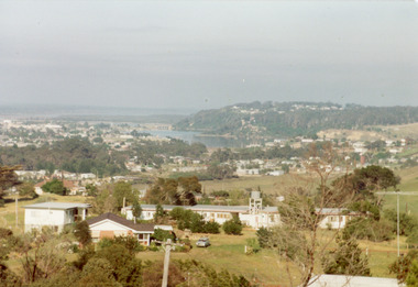
 Lakes Entrance Historical Society
Photograph - Township, Fish, Marie, 1985c
\Colour photograph of township showing, North Arm and North Arm Bridge, Jemmys Point, Mount Barkly, Kalimna Heights on right, Cunninghame Arm and sand dunes on left. Looking towards Bullock Island and Rigby Island and Hopetoun Channel in centre background. Sea Vista flats in foreground. Photo take from near Telecom Tower on Merrangbaur Hill circa 1985. Lakes Entrance Victoria bridges, waterways, township -
 Lakes Entrance Historical Society
Photograph - Township, Fish, Marie, 1985c
Colour photograph of township showing, North Arm and North Arm Bridge, Jemmys Point, Mount Barkly, Kalimna Heights on right, Cunninghame Arm and sand dunes on left. Looking towards Bullock Island and Rigby Island and Hopetoun Channel in centre background. Sea Vista flats in foreground. Photo take from near Telecom Tower on Merrangbaur Hill circa 1985. Lakes Entrance Victoria bridges, waterways, township -
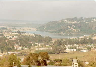
 Lakes Entrance Historical Society
Photograph - Township, Fish, Marie, 1985c
Colour photograph, image of part of township, showing Jemmys Point, Mount Barkly, North Arm and old North Arm bridge, football ground mid picture. View towards Rigby Island, Hopetoun Channel and dunes. Photo taken using telephoto lenses from near Telecom Tower on Merrangbaur Hill. Lakes Entrance Victoria bridges, waterways, township -
 Lakes Entrance Historical Society
Photograph - Township, Fish, Marie, 1985c
Colour photograph of township, showing buildings, Jemmys Point, Mount Barkly, Kalimna Heights, North Arm and old North Arm bridge, and Rigby Island beyond. Sea Vista flats in foreground. Photo taken from near Telecom Tower on Merrangbaur Hill. Lakes Entrance Victoriatopography, township, waterways, bridges -
 Lakes Entrance Historical Society
Photograph - Township, Fish, Marie, 1985c
Colour photograph of part of township showing Jemmys Point, Mount Barkly, Kalimna Heights, North Arm & old North Arm bridge, looking beyond to Rigby Island. Photo taken from near Telecom Tower on Merrangbaur Hill. Lakes Entrance Victoriatopography, township, waterways, bridges