Showing 24285 items matching "oceans"
-
 Warrnambool and District Historical Society Inc.
Booklet - Warrnambool Visitor's Handbooks 1979-2024, Collett, Bain and Gaspar, Printers, 1979-2014
This is a collection of eight Warrnambool Visitor handbooks produced between 1979 and 2014 by the City of Warrnambool Tourist Information Centre. They contain maps of Warrnambool, lists of services, accommodation and tourist attractions as well as many advertisements for local businesses.These handbooks give a useful snapshot of businesses and tourist attractions in Warrnambool for each of the years covered. (1979, 1980, 1986, 1990, 1993, 1994, 1995, 2014)[.1a] A 48 page booklet with white pages and blue printing. The front cover has a coloured photograph of Flagstaff Hill with boats on a man made lake in the foreground looking across Lake Pertobe toward South Warrnambool. [.1b] A coloured bifold brochure. The front cover has a fisherman on a cray-boat holding a crayfish in the lower section. The top quarter has a blue back ground with white printing. The rear cover is red and has small photos of the Hopkins River and the Framlingham Forest. [.2] A 48 page booklet with white pages and black printing. The front cover is white with black writing on the left hand side and a colour photograph of the Loch Ard peacock. The Warrnambool Premier Town stylised logo of seven Norfollk pines above blue waves is in the top right hand corner. There is a blank ink Warrnambool Library stamp underneath the logo. The rear cover has photographs of The Twelve Apostles and the Hopkins Falls and the Premier Town Logo [.3] A 40 page booklet with mainly black printing on white paper. There are three fold out maps of Warrnambool and the surrounding district. The glossy cover has a black background with a colour photograph of the Twelve Apostles taken at sunset. The rear cover has three small of Proudfoot's boathouse on the Hopkins River, Flagstaff Hill, and the main beach area. The front cover has black writing inside to peach coloured rectangles. The inside rear cover has a fold out coloured tour map of Western Victoria. [.4] A 40 page booklet printed on glossy white paper with coloured photographs and black and red printing. The front cover has a photograph of The Twelve Apostles surrounded by a white border. There is red writing in the upper border. There is a sandy coloured writing superimposed across the bottom of the photograph and a Victoria's Shipwreck Coast logo in the bottom right hand corner. [.5] A 44 page booklet printed on white paper with black printing. The cream coloured cover has a pale red rectangle with blue writing on the right hand facing edge and includes two stylised Norfolk pines and with waves underneath. There is is an intersecting blue rectangle with cream printing. [.6] A 48 page booklet printed on white paper with black printing. The cover is brown with a cream vertical strip containing black writing on the right hand side. There is a stylised map from Geelong to Mount Gambier showing the Great Ocean Road across the cover. [.7] A 48 page booklet printed on white paper with black print. The glossy colour cover has a photograph of a Southern Right whale fluke. There is white printing on a the blue background of the sky and sea. The bottom left hand side of the front cover has a Tourism Victoria logo made of jigsaw puzzle pieces. The back cover has a stylised coloured map of The Great Ocean Road located in a white rectangle at the top of the page. Within the rectangle is a small map of Australia locating Victoria and the part of Victoria covered by the map. [.8] A 64 page A5 coloured booklet printed on white pages with black print. The white front cover has black and grey print with a colour photograph of two people holding coffee cups watching four race horses being exercised on the beach and in the water of Lady Bay in the early morning. The bottom right hand corner has a Tourism Victoria logo. The rear cover has a mainly blue back ground with a pink orange and green colour splats contains words advertising the 2015 Fun 4 Kids Festival [.1a] Warrnambool The Heart of Victoria's Great Southwest Visitor's Handbook [.1b] Warrnambool City for all seasons; The Heart of Victoria's Great Southwest [.2] Warrnambool visitor's handbook Warrnambool Premier Town 1979-1982 [.3] Warrnambool Handbook Victoria [.4] Warrnambool The Shipwreck Coast [.5] Welcome to Warrnambool Warrnambool Visitors Handbook 1993-1994 [.6] Welcome to Warrnambool Visitors Handbook 1994-95 Rear cover: Warrnambool Centre of Victoria's Shipwreck Coast on Australia's Great Ocean Road [.7] Warrnambool Shipwreck Coast - Great Ocean Road; You'll love every piece of Victoria; Visitors Handbook [.8] Warrnambool Great Ocean Road Official Visitor Guide; It's a wonderful Warrnambool; You'll love every piece of Victoria visitvictoria.com. Rear Cover Live entertainment.Workshops.Creativity.Action 28 June - 5 July 2015 Australia's Best Children's Festival F4K The ultimate winter school holiday adventure Fun 4 kids festival Warrnambool For more information visit Fun4kids.com.au Warrnambool great Ocean Road Victoriawarrnambool, visitor handbooks, tourist information guides, warrnambool maps -
 Mission to Seafarers Victoria
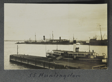
photograph - Photograph, Sepia, SS Huntingdon, 1928
Known to have run between London and New Zealand.small landscape sepia photograph of two vessels in the foreground a ferry or coaster moored at small wooden quay and in the distance moored at a pier an ocean going steamship with one stack or funnel.handwritten inscription on album page beneath image: Huntingdonss huntingdon, fan album, ships, port melbourne -
 Glenelg Shire Council Cultural Collection
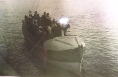
Photograph - Photograph - Portland Lifeboat going to the rescue, n.d
Sepia photo showing the Portland Lifeboat on ocean. Crew of 12. Man using oar to push off from pier. Man holding tiller. Men wearing life jackets.portland lifeboat, rescue, ocean -
 Glenelg Shire Council Cultural Collection
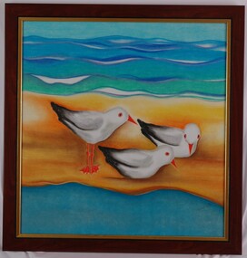
Painting, Home at Narrawong, c. 1999
Exhibition in the Arts Company in 1999?Painting of three seagulls standing on a sandbar between river and ocean. Painted in bright colours, predominantly blues, green and orange. Framed under glass in wooden and gold-coloured frame.Front: (no inscriptions) Back: (no inscriptions)narrawong, painting, seagulls -
 Glenelg Shire Council Cultural Collection
Photograph - Photograph - Portland Harbour, n.d
Con Kroker Private CollectionBlack & white photo. Fisherman's Breakwater on right. Ocean Pier, Whaler's Bluff lighthouse in background. Salt Creek running into sea on lfet, three children fossicking in rocks in foreground. -
 Glenelg Shire Council Cultural Collection
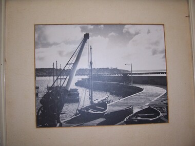
Photograph - Photograph - Fisherman's breakwater, Portland, n.d
On display at History House.Framed, black and white photograph of fishermen's breakwater Portland, showing breakwall crane and dinghies in foreground on breakwater. Fishing boats behind crane. Ocean pier, lighthouse bluff in background.Front: - Back: Mr. Barry Hocken Portland - in blue pencil -
 Glenelg Shire Council Cultural Collection
Photograph - Photograph - aerial view of Portland, c. 1954
Black and white aerial photograph of coastline around Portland. Black border, scale all sides, 5 rows of 3 't' at regular intervals. Ocean on left, land on rightFront: '607 - 54 ' - handwritten, white, border 'RUN 7' 'PORTLAND', printed, white, borderaerial photography, central portland, portland harbour, south west coastline -
Glenelg Shire Council Cultural Collection
Photograph - Photograph - aerial view of Portland, c. 1954
Black and white aerial photograph of coastline around Portland. Black border, scale all sides, 5 rows of 3 't' at regular intervals. Ocean at right, land on left.Front: '820 - 7' -- handwritten, white, lower border 'RUN 5' 'PORTLAND', printed, white, lower borderaerial photography, central portland, portland harbour, south west coastline -
Glenelg Shire Council Cultural Collection
Photograph - Photograph - aerial view of Portland, c. 1954
Black and white aerial photograph of coastline around Portland. Black border, scale all sides, 5 rows of 3 't' at regular intervals. 50/50 land and oceanFront: '607 - 51 ' - handwritten, white, border 'RUN 7' 'PORTLAND', printed, white, borderaerial photography, central portland, portland harbour, south west coastline -
Glenelg Shire Council Cultural Collection
Photograph - Photograph - aerial view of Portland, c. 1954
Black and white aerial photograph of coastline around Portland. Black border, scale all sides, 5 rows of 3 't' at regular intervals. 75/25 ocean to landFront: '784-146 ' - handwritten, white, border 'RUN - 7 A PORTLAND', printed, white, borderaerial photography, central portland, portland harbour, south west coastline -
Glenelg Shire Council Cultural Collection
Photograph - Photograph - aerial view of Portland, c. 1954
Black and white aerial photograph of coastline around Portland. Black border, scale all sides, 5 rows of 3 't' at regular intervals. 60/40 land to ocean.Front: '607 - 93 ' - handwritten, white, border 'RUN - 6 PORTLAND', printed, white, borderport of portland archives, aerial photography, portland harbour, south west coastline -
Glenelg Shire Council Cultural Collection
Photograph - Photograph - Aerial photograph of coastline, Portland Victoria, c. 1954
Black and white aerial photograph of coastline around Portland. Black border, scale all sides, 5 rows of 3 't' at regular intervals. 80/20 ocean to landFront: '784 - 147 ' - handwritten, white, border 'RUN 7 A PORTLAND', printed, white, border -
Glenelg Shire Council Cultural Collection
Photograph - Photograph - aerial view of Portland, c. 1954
Black and white aerial photograph of coastline around Portland. Black border, scale all sides, 5 rows of 3 't' at regular intervals. 90/10 ocean to landFront: '784 - 148'- handwritten, white, border 'RUN 7 A PORTLAND', printed, white, borderaerial photography, central portland, portland harbour, south west coastline -
Glenelg Shire Council Cultural Collection
Photograph - Photograph - aerial view of Portland, c. 1954
Black and white aerial photograph of coastline around Portland. Black border, scale all sides, 5 rows of 3 't' at regular intervals. 20% ocean, 80% land.Front: '820 -51' - handwritten, white, border 'RUN 6' 'PORTLAND', printed, white, borderaerial photography, central portland, portland harbour, south west coastline -
Glenelg Shire Council Cultural Collection
Photograph - Photograph - Ocean Pier, Portland, n.d
Black and white photo of section of Ocean Pier, taken on pier. Steamship the Australford berthed outside of pier, railway goods trucks obscuring view of vessel, several people on pierFront: ' "Australford" at Portland Pier', white writing, bottom rights s australford, steamship, cargo, rail cargo, transport, portland harbour -
Glenelg Shire Council Cultural Collection
Photograph - Photograph - Portland central township and Portland Harbour, 05/03/1971
Port of Portland Authority archivesFront: (no inscriptions) Back: (no inscriptions)port of portland archives, portland harbour, portland central town, no6 berth development, ocean pier demolition, baths demolition -
Glenelg Shire Council Cultural Collection
Photograph - Photograph - aerial view of Portland Harbour, n.d
Port of Portland Authority Archivesport of portland archives, aerial photography, portland harbour, k s anderson wharf -
Glenelg Shire Council Cultural Collection
Photograph - Photograph - Main Breakwater, Portland, n.d
Port of Portland Authority Archivesport of portland archives, main breakwater, construction, ocean pier, dutton way -
Glenelg Shire Council Cultural Collection
Photograph - Photograph - Lee Breakwater, Portland, n.d
Port of Portland Authority Archivesport of portland archives, portland harbour, lee breakwater, ocean pier, railway pier, construction -
 National Vietnam Veterans Museum (NVVM)
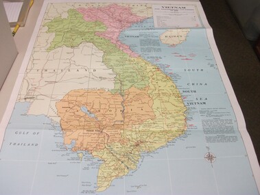
Map - Map, Vietnam and surrounding countries
Paper map of Vietnam, Laos, Thailand, Hainan Island, Cambodia & Burma. Coloured print, very detailed. Showing surrounding oceans & information on climate & population of North & South Vietnam.vietnam map -
 Kew Historical Society Inc
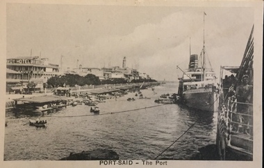
Postcard, The Cairo Postcard Trust, Port Said - The Port, c.1918
One of a number of 'real photo' and commercial postcards created by or owned by members of the Christian and Washfold families of Kew. The postcards are part of a larger collection of photographs, postcards and publications donated to the collection in May 2021.Sepia postcard of the Port at Port Said, located on the north east coast of Egypt on the Mediterranean Sea, showing buildings including the Savoy Hotel and boats at left and ocean liner at rightThe Cairo Postcard Trust Cairo 949. Serie 632christian-washfold collection, postcards -- port said (egypt) -
 Lakes Entrance Historical Society
Photograph - April Hamer, Fraser, Ian, 1980 c
Colour photograph of the side casting dredge, April Hamer, working at the entrance. Ocean in background, entrance to Gippsland Lakes. Photo shows rock groynes at entrance. Lakes Entrance Victoriajetties, waterways, ships and shipping -
 Lakes Entrance Historical Society
Photograph - Ocean Rescue, Lakes Post Newspaper, 1999
Colour photograph taken on Traders Day, fund raising event for Ocean Rescue Squad, few people sitting on beach, Donna Knorr, others unknown. Lakes Entrance Victoria volunteering, emergency services, fundraising -
Lakes Entrance Historical Society
Book, M Holding, Inquest into drownings - Jemmeson, Lambert, Smith, Cane, 2010c
Inquests and Inquiries and information on deaths of Frank Jemmeson Charles Edward Lambert Richard Smith and Alfred Lang Cane all involved in fishing around lakes and ocean Gippsland victoriafishing industry, inquests -
Lakes Entrance Historical Society
Book, Bird Geoff, Survival at Sea - The Lakes Entrance Ocean Rescue Squad, 1991
A short history of the Lakes Entrance Ocean Rescue Squad Victoria, includes action to be taken before crossing the Lakes Entrance Bar and distress procedure, contains photographs of boats and rescues.boats and boating, safety, community services -
 Lakes Entrance Historical Society
Photograph - Tres Amigo's Mexican Restaurant, Lakes Post Newspaper, 1/03/1993 12:00:00 AM
June and John Parsons sold Tres Amigos Mexican Restaurant in September 1993Black and white photograph of John Parsons catering for Ocean Rescue Annual Dinner 1993 from Tres Amigos Mexican Restaurant 1 521 Esplanade Lakes Entrance Victoriarestaurant, businesses, catering -
 Lakes Entrance Historical Society
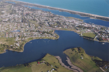
Photograph - North Arm Lakes Entrance, 2005 c
Also two colour photographs of North Arm area taken from Leigh and Judy Davies Blair Road Lakes Entrance number 03859.1 and 03859.2 sizes 10 x 15 cm and 15 x 10 cmColour aerial photograph showing Kalimna in foreground, North Arm, towhship, Cunninghame Arm and across to ninety mile beach and Bass Strait ocean beach Lakes Entrance Victoriaaerial photograph, settlement -
 Lakes Entrance Historical Society
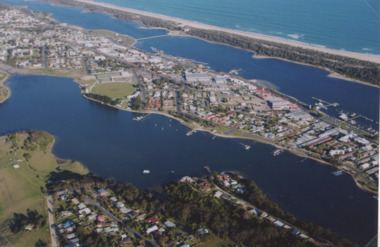
Photograph - North Arm Lakes Entrance, 2005
Colour aerial photograph showing North Arm, township, eastern end of Cunninghame Arm across to the ocean beach, Ninety Mile beach, Bass Strait Lakes Entrance Victoriaaerial photograph, aircraft, lakes entrance -
![Painting, untitled [Portland Port], n.d](/media/collectors/4f729f5597f83e03086015b1/items/655a82f77f3f3810362edb30/item-media/655a83847f3f3810362ef766/item-fit-380x285.jpg) Glenelg Shire Council Cultural Collection
Glenelg Shire Council Cultural CollectionPainting, untitled [Portland Port], n.d
Art Collection Previously located in History HouseThe painting depicts the Portland Port from an aerial perspective. The perspective is taken from the ocean looking down across the Port and into the town of Portland. Within the foreground is the ocean beyond the Main Breakwater, the Main Breakwater and the Port. Within the Port nine large ships are docked and another is being brought into the Port by two tugboats. The background features a distant view of the town of Portland and the landscape beyond the township. The work has a white wooden frame and glass.Front: TROMPF (white paint, bottom right corner) Back: (no inscriptions) -
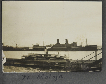 Mission to Seafarers Victoria
Photograph - Photograph, Sepia, P. O. Maloja, 1928
Named after another ship operating from 1911, RMS Maloja was a passenger liner of the Peninsular and Oriental Steam Navigation Company, operating between 1923 and 1954. In 1924: London/Colombo/Melbourne/Sydney service. During WWII the ship was requisitioned by the Admiralty for service as an Armed Merchant Cruiser.One of two photographs in the collection of a vessel named Maloja, which operated between London and Sydney via Ceylon (Sri Lanka as it later became).small landscape sepia photograph adhered to an album page. Depicts 2 vessels an ocean going 2 stack ship in the distance and a smaller vessel (ferry or coaster) moored against a pier.Hand-written on album page along lower edge in black ink: " PO Maloja"steam ships, world war 2, fan album, ships, piers, port melbourne