Showing 114420 items
matching orbost-brodribb-road
-
 Orbost & District Historical Society
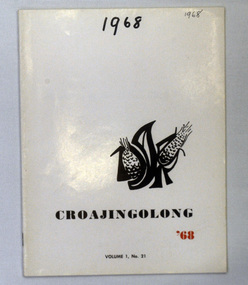
magazines, Croajingolong 1968, 1968
This is the twenty-first issue of the annual Orbost High school magazine. The name Croajingolong derives from the Australian Aboriginal Krauatungalung words galung, meaning "belonging to" and kraua, meaning "east". 2216.1 belonged to Mary Gilbert, a former teacher at the school. 2216.2 belonged to Brenda Murray, a former mayor of East Gippsland Shire and a prominent Orbost resident.This magazine is a useful reference tool.Two copies of a magazine, Croajingolong '68. It has a white cover with black and red print,. Vol.1 No.21. On the right side is a stylised drawing of two ears of corn with black letters (?) around it. (OHS?)2216.2 is stamped Orbost & District Historical Society.croajingolong orbost-high-school -
 Orbost & District Historical Society
black and white photographs, Snowy River Mail, 1990
Wendy Blackburn was in charge of T.A..F.E. Orbost and the photographs were taken in her office. Also in the photographs are Tracey Barnett, Peter Cook and Dan Osborne. The Orbost Education Centre is a community based not-for-profit local organisation. It has been in operation since 1976. The programs respond to the needs of the community and short courses are delivered throughout the year for people of all ages and backgrounds. The basis is promoting learning, connectedness and belonging. It is supported by funding from the community, state government and non-government organisations. TAFE offered adult education to those new out of school and mothers coming out of motherhood as well as others. These photographs are pictorial records associated with adult education in Orbost.Five black / white photographs related to adult learning in Orbost. education-adult-orbost t.a.f.e.-orbost -
 Orbost & District Historical Society
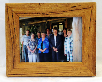
framed photograph, 14.4.2004
This photograph was taken on 14.4.2004 at the time of the visit to Orbost by the Governor of Victoria, John Landy.The Orbost Visitor Information Centre is situated in Forest Park on Nicholson Street. The centre is housed in the historic Slab Hut. The hut was an original family dwelling built in 1872, on a site approximately three kilometres upstream from the junction of the Buchan and Snowy Rivers. The Slab Hut is an Orbost Icon. It supports one part time manager and a team of dedicated volunteers.A coloured photograph in a wooden frame. A group of people stand in front of the Slab Hut (Orbost Information Centre) .On frame - NATURAL FEATURED HARDWOOD MADE BY 20.12.98 W. ASHLYN MARLO VIC.slab-hut-committee photograph -
 Stawell Historical Society Inc
Map, R.O. Robson - Authorised Surveyor, Road from Glenorchy to near Geary's Selection Callawaddy 1880, 29.04.1880
Survey for Road CreationCloth Backed Map. Plan of Road.Parishes of Richella & Callawadda. County of Borong. Plan of Road. R.O. Robson Authorised Surveyor Stawell 29.04.80 -
 Orbost & District Historical Society
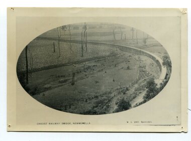
black and white photograph, Vogt. W.S, first half 20th century
In 1912 work was underrway on the Bairnsdale to Orbost railway. It was opened on April 10 1916. The two bridges on the railway viaduct, which crosses the Snowy River floodplain at Orbost, were built from local Southern Mahogany. The bridge on the Bairnsdale end (770m) is now the longest in Victoria. (info. Helen Martin)This item is associated with the history of the Orbost-Bairnsdale railway line and therefore reflects the role that the rail line played in the social and economic history of Orbost.A black / white photograph, oval-shaped on white background. It is of the railway viaduct across the flats at Orbost,.photo caption -"ORBOST RAILWAY BRIDGE, NEWMERELLA E. S. Vogt, Bairnsdale"newmerella orbost-viaduct east-gipsland-railway -
 Orbost & District Historical Society
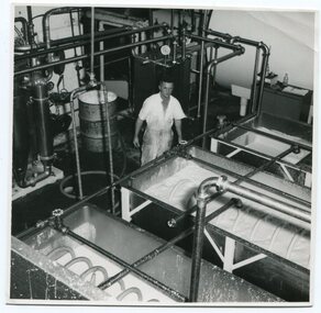
black and white photograph, mid 20th century
This photograph was taken inside the Orbost Butter Factory.The Orbost Butter and Produce Co. Ltd was registered on June 1st 1893 and was an important source of income to the Orbost district.A b/w photograph of a man in a white short-sleevedoverall standing behind vats of butter inside the Orbost Butter Factory. -
 Orbost & District Historical Society
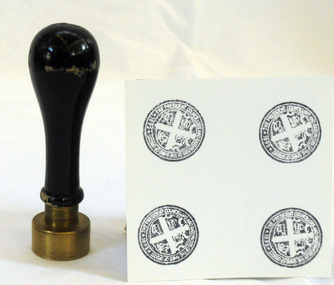
Council Seal
This item was used as a seal (stamp) on official Shire Council documents. The coat of arms of the Shire of Orbost was designed in the form of a cross in which five stars are depicted on a shield. A small crown above the cross indicates the loyalty of the president,councillors and ratepayers to the reigning monarch. The inner section of the shield contains 4 figures, a sheaf of wheat, a factory, a co and a ship - all representing the activities of agriculture, fishing,industry and dairying undertaken in the shire. Originally part of the Bairnsdale district, Orbost split away as part of the Tambo Shire in 1882, and became a shire in its own right as the Shire of Croajingolong on 30th May,1892. The name was changed to the Shire of Orbost on 17th February, 1893. The Orbost Shire Council was abolished on 2nd December, 1994 as part of a state-wide program of local government reform to become part of the newly constituted East Gippsland Shire council.Local governments play an important role in the lives of citizens in Australia. Local government authorities exist to provide services and amenities to local communities, and are also responsible for regulating and providing services for land and property in their district. This item is representative of a time when Orbost had its own Shire Council.The former Orbost Shire Council Seal (stamp) depicting the coat of arms. The circular seal is brass and has a wooden handle with a bulb shaped top.President, Councillors and Ratepayers of the Shire of Orbost-1892orbost orbost-shire-council government history seal -
 Glen Eira Historical Society
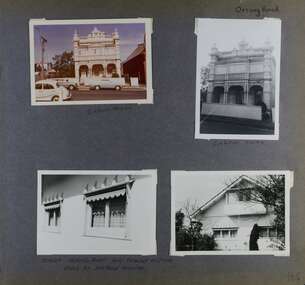
Album - Album page, Orrong Road, Circa 1972
This photograph is part of the Caulfield Historical Album 1972. This album was created in approximately 1972 as part of a project by the Caulfield Historical Society to assist in identifying buildings worthy of preservation. The album is related to a Survey the Caulfield Historical Society developed in collaboration with the National Trust of Australia (Victoria) and Caulfield City Council to identify historic buildings within the City of Caulfield that warranted the protection of a National Trust Classification. Principal photographer thought to be Trevor Hart, member of Caulfield Historical Society. Most photographs were taken between 1966-1972 with a small number of photographs being older and from unknown sources. All photographs are black and white except where stated, with 386 photographs over 198 pages.Victorian Heritage Database https://vhd.heritagecouncil.vic.gov.au/places/35576 No. 70 Orrong Road is important as an exceptionally ornate Boom style villa residence in the terraced form and in this respect is rare in Caulfield. Its architectural value is enhanced by its intact state and by the manner in which its bold architectural expression is carried through into the hallway and staircase. Victorian Heritage Database - National Trust local significance 284 Orrong Road Caulfield https://vhd.heritagecouncil.vic.gov.au/places/65700 A house designed by Harold Desbrowe Annear in 1917 and believed to have been the first "all electric" house in Melbourne. It has been extensively altered.Page 164 - four photographs of 2 different houses on Orrong Road. The top left photo is in colour while the others are in black and white.Handwritten: Orrong Road [top right] / Lisborn House [ (ed. correct name is LISBON HOUSE), under top left photo] / Lisborn House [under top right photo] / [under bottom right photo] / CORNER ORRONG ROAD AND PEARSON AVENUE / HOUSE BY DESBROWE ANNEAR [under bottom left photo] / 164 [bottom right]trevor hart, orrong road, lisbon house, lisborn house, elsternwick, pearson grove, st kilda east, caulfield north, terrace houses, cast iron work, verandahs, balconies, parapets, arches, cars, streetscapes, attic houses, desbrowe annear -
 Glen Eira Historical Society
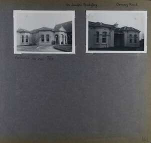
Album - Album page, St Joseph's Presbytery, Orrong Road, Circa 1972
This photograph is part of the Caulfield Historical Album 1972. This album was created in approximately 1972 as part of a project by the Caulfield Historical Society to assist in identifying buildings worthy of preservation. The album is related to a Survey the Caulfield Historical Society developed in collaboration with the National Trust of Australia (Victoria) and Caulfield City Council to identify historic buildings within the City of Caulfield that warranted the protection of a National Trust Classification. Principal photographer thought to be Trevor Hart, member of Caulfield Historical Society. Most photographs were taken between 1966-1972 with a small number of photographs being older and from unknown sources. All photographs are black and white except where stated, with 386 photographs over 198 pages. St Joseph's buildings and grounds are contributory properties to HO72 Elsternwick Estate and environs - City of Glen Eira.Page 162 - two photographs of St Joseph's Presbytery, Orrong Road.Handwritten: St Joseph's Presbytery Orrong Road [top right] / PREVIOUSLY "THE EMS" 1908 [under left photo] / 162 [bottom right]trevor hart, orrong road, curved windows, decorative brackets, arched windows, bay window, portico, slate roof, st joseph's presbytery, catholic church, st joseph's church, st joseph's primary school, porte cochere, the ems, elsternwick, rendered walls, clergy residences, drives, late victorian style, house names -
 Orbost & District Historical Society
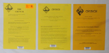
newsletters, The Crunch, 1995 1996
These newsletters were created as an ACCESS project at the Orbost centre of TAFE (Technical and Further Education). Community newsletters are published by local groups and provide community news and information. In small rural communities they are an important communication medium.Three issues of a newsletter titled The Crunch. This was a newsletter for the Orbost community and contains articles on Orbost events. Most articles refer to TAFE Outreach Services. 2407.1 and 2407.2 are printed on yellow paper. 2407.3 has 3 orange sheets and 2 yellow sheets. All are stapled. 2407.1 has a label on the front with East Gippsland Shire Library and a bar code. 2407.2 has a bar code and LOCAL Newsletter written in pencil. 2407.3 has a stamp - EAST GIPPSLAND LIBRARY SERVICE and LOCAL written in pencil.newsletters tafe-orbost -
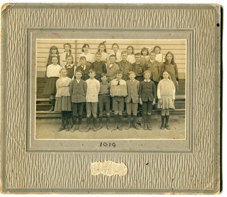 Orbost & District Historical Society
black and white photograph, Wilson, Les G, 1919
The 19th of March 1886 proved an important day in the lives of many early settlers in the Orbost area, because on this day the Orbost State School opened. The fact that the school had first operated temporarily in a leased building, and on a half-time basis with SS2745 Jarrahmond, did not dampen the enthusiasm of the local inhabitants as they saw their offspring commence their education under the guidance of HT Campbell Mackay. However he remained in charge only until 12th of May 1886. The second HT, John Rowe, served until 1908. On 30th of June 1887, a portable room was provided; it being brought to the area by schooner. The school now had accommodation for 30 pupils; the teacher's welfare was considered because quarters of two rooms were attached. As the population increased so did the needs of the school. This was reflected in the provision of a larger classroom in 1898. During 1910-11 the first approaches were made to the Department for the establishment of a HES in Orbost and this became a reality in 1912. Orbost HES supplied post-primary education in the district until a high school was built in 1948. When fire destroyed the school in 1941 local halls were used as classrooms until a new school was built. Work was quite rapid and a new brick structure was opened by the Hon. A. E. Lind, MLA, on 13th of February 1942. This new building was a fine type of school of which both the pupils and the HT Leslie Collins were indeed proud. But Orbost continued to develop and the new school was soon overtaxed. This resulted in the erection of two Bristol classrooms in 1947. By 1950, when the school population had reached 500 pupils the opening of the new school at Orbost North was welcomed by all concerned. In 1963 the Department purchased land diagonally opposite the school and developed it as a playing area. In 1965 two LTCs were opened in November, and in October 1968 the Brodribb School building was moved to SS2744 Orbost for use as a general purpose room. ( Info. from Schools East Gippsland) This item is associated with the history of education in Orbost.A black / white photograph on a grey buff cardboard frame. It is of a group of students standing outside the Orbost State School building. One child holds a sign reading "Form F". There is a photographer's label at the bottom.on back - "Alen Roach" on front - "1919" education-orbost orbost-state-school -
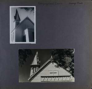 Glen Eira Historical Society
Album - Album page, Congregational Church, Grange Road, Circa 1972
This photograph is part of the Caulfield Historical Album 1972. This album was created in approximately 1972 as part of a project by the Caulfield Historical Society to assist in identifying buildings worthy of preservation. The album is related to a Survey the Caulfield Historical Society developed in collaboration with the National Trust of Australia (Victoria) and Caulfield City Council to identify historic buildings within the City of Caulfield that warranted the protection of a National Trust Classification. Principal photographer thought to be Trevor Hart, member of Caulfield Historical Society. Most photographs were taken between 1966-1972 with a small number of photographs being older and from unknown sources. All photographs are black and white except where stated, with 386 photographs over 198 pages. This church has since become the Greek Orthodox Church. From Victorian Heritage Database: Citation for Greek Orthodox Church HO84 https://vhd.heritagecouncil.vic.gov.au/places/43587 (as at 19/10/2020) The former Primitive Methodist, later Congregational, church at 152 Grange Road, Glenhuntly, is a small timber building, erected in 1885 (89?) in South Melbourne and relocated to Glenhuntly in 1909. It is a highly individual picturesque timber structure with distinctive spire and timber enrichment. It has aesthetic, historical and social significance. Its aesthetic value is derived from the choice of materials and picturesque Gothic Revival character showing American influence. Its historical value is derived from its survival as a rare example of a Primitive Methodist Church building whilst its social value hinges on its early roles as a place of worship for the Primitive Methodists in South Melbourne and the Congregationalists in Glenhuntly.Page 72 of Photograph Album with two photographs (one portrait and one landscape) of the upper exterior and tower of the Congregational Church on Grange RoadHand written: Congregational Church, Grange Road [top right] / 72 [bottom right] trevor hart, congregational church, grange road, gothic revival, carnegie, glen huntly, glenhuntly, greek orthodox church, primitive methodist church, spire, timber buildings -
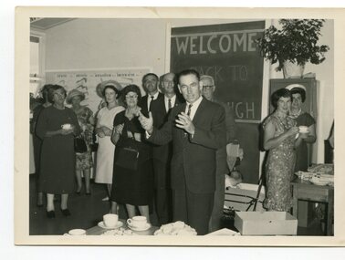 Orbost & District Historical Society
black and white photograph, 1962
This photo shows Bert May addressing a group of ladiers at the 1962 Golden Jubilee of the Orbost High School. Bert May served as the Member for Gippsland in the Legislative Council from 1957 until 1973. With earlier levels of schooling available at the Orbost State School or nearby schools of Newmerella and Jarrahmond School, it was not until April 1912, and after much campaigning from parents and other notable community members, that the Orbost Higher Elementary School was opened. Mr Richard Trembath was appointed the new Head teacher of Orbost Higher Elementary School and was assisted by Miss Olga Hirst. The senior class consisted of 26 pupils, and the junior class, 16 pupils. A limited curriculum was available which included lessons in Latin, Arithmetic, Algebra, Geometry, Geography, History, Drawing and advanced English. (ref. O.S.C. website)Orbost High School / Orbost Secondary College has played a significant part in the education of senior students in the Orbost district . It is the sole senior educational institution. This item is representative of its history and is a useful reference tool.A black / white photograph of a man giving a speech to a group of ladies in a classroom. all are standing.on back - Bert May, Orbost H.S. Jubilee 1962orbost-education orbost-high-school -
 Glen Eira Historical Society
Album - Album page, Heatherbrae, 73 Neerim Road, Circa 1972
This photograph is part of the Caulfield Historical Album 1972. This album was created in approximately 1972 as part of a project by the Caulfield Historical Society to assist in identifying buildings worthy of preservation. The album is related to a Survey the Caulfield Historical Society developed in collaboration with the National Trust of Australia (Victoria) and Caulfield City Council to identify historic buildings within the City of Caulfield that warranted the protection of a National Trust Classification. Principal photographer thought to be Trevor Hart, member of Caulfield Historical Society. Most photographs were taken between 1966-1972 with a small number of photographs being older and from unknown sources. All photographs are black and white except where stated, with 386 photographs over 198 pages.From Victorian Heritage Database citation for Heatherbrae HO46 https://vhd.heritagecouncil.vic.gov.au/places/120933 as at (28/10/2020) "Heatherbrae" at 73 Neerim Road, Glenhuntly, is a substantial Victorian residential complex made up of two principal construction stages (pre 1876 and c. 1890) and outbuildings including stables. It is aesthetically, historically and socially significant. Its aesthetic value is demonstrated by the manner in which the two periods of construction survive, the earliest being of greater architectural interest on account of its tower and facade treatment, the latter phase adopting a common villa form. The importance of the complex is heightened by its intact state and surviving outbuildings. "Heatherbrae's" historical significance lies in its link with locally known business man and Shire of Caulfield councillor, John Charles Holland. Its social value rests on its ability to demonstrate a past lifestyle. Page 143 of Photograph Album with 2 landscape photographs of Heatherbrae on Neerim Road - paving insignia and side view.Handwritten: "HEATHERBRAE" 73 NEERIM ROAD [top] / STABLE [under bottom photo] / 143 [bottom left]trevor hart, chimneys, cast iron columns, return verandah, garden, 1870's, neerim road, booran road, 1880's, 1890's, mansion, john c. holland, bluestone foundations, italianate, iron roofed balcony, cast iron balustrade, mosaic tiles, cast iron lookout, flagpole, george f griffiths, residential villa, caulfield, heatherbrae, victorian style, cast iron work, stables, outbuildings, john holland, george griffiths, councillors, mansions -
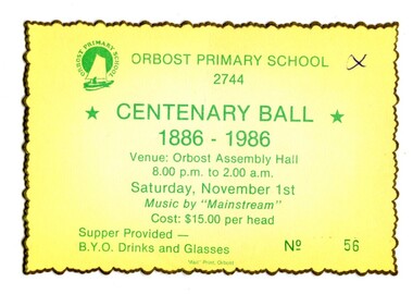 Orbost & District Historical Society
ticket, Snowy River Mail as "Mail" Print, 1986
Colours of ticket reflect school, colours of green and yellow. The ticket was issued for a ball/celebration for the centenary of Orbost Primary School. This school was the earliest primary school in Orbost established in 1886.Orbost Primary School was the earliest primary school in Orbost. A centenary celebration ball would have been a popular local event.A rectangular shaped yellow card with a fluted gold edge. Printed in green is "ORBOST PRIMARY SCHOOL 2744 CENTENARY BALL 1886 - 1986 Venue - Orbost Assembly Hall 8.00pm -2.00am Saturday Nov. 1st Music by "MAINSTREAM" Cost $15 per head. Supper provided -BYO drinks & glasses." In bottom right corner is No.56orbost-primary-school-centenary celebration -
 Orbost & District Historical Society
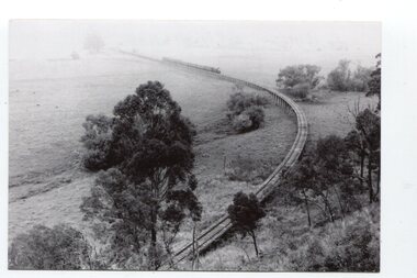
black and white photographs, Jude, Ray, 1915 - 1969
These photographs relate to the East Gippsland Railway. The Bairnsdale-Orbost railway was opened in 1916 to serve the agricultural and timber industry. Because of the decline in traffic and heavy operating costs, the line was finally closed in August, 1987. Orbost Railway Station was opened on Monday 10 April 1916 as the terminus of the Orbost railway line, and closed in 1987. The station was located on the west side of the Snowy River despite the town of Orbost being on the east side of the river, in order to save on the costs of a bridge over the river, which at the time had highly variable levels. These photographs are associated with the history of the Orbost-Bairnsdale railway line and therefore reflects the role that the rail line played in the social and economic history of Orbost.Seven black / white photographs and one postcard print.3103.1 on back - " Orbost- Snowy River flats viaduct 22-2-1964 ARHS special train Ray Jude photo" 3103.2 - on back -" Orbost Snowy River flats viaduct A.R.H.S. special train 22.2.1969" 3103.3 - on back - " A.R.H.S. special across bridge between Waygara & Nowa Nowa 22-2-1964 3103.4 - on back - " Nowa Nowa Boggy Creek Bridge A.R.H.s. Orbost tour Ray Jude photo" 3103.5 - on back - " Orbost 22-2-1969 SM office & goods shed Ray Jude photo" 3103.6 - on back - " Orbost Railway Yards - 22 February 19369 Ray Jude photo" 3103.7 - on back - " Orbost May 27 -1936 Orbost Rail Station" 3103.8 - on front - caption - Unloading Ballast Orbost line near Newmerella 1915 - J. Sullivan Colin ?orbost-railway east-gippsland-railway bairnsdale-orbost-railway -
 Orbost & District Historical Society
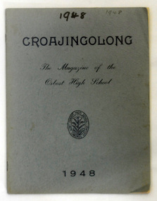
magazine, Snowy River Mail as "Mail" Print, Croajingolong 1948, 1948
This is the first issue of the Orbost High School annual magazine. The name Croajingolong derives from the Australian Aboriginal Krauatungalung words galung, meaning "belonging to" and kraua, meaning "east". This book belonged to Mary Gilbert, a teacher at the school.This is the first edition of the Orbost secondary school magazine and is a useful reference tool. A 32 pp grey covered magazine titled Croajingolong 1948. It is the annual magazine of the Orbost High School. It has an Orbost High School badge in black print on the front cover. This is the first issue of the magazine.croajingolong orbost-high-school -
 Mt Dandenong & District Historical Society Inc.
Photograph, The Mt Dandenong Road c1930, c1930
Formed, unmade road. Possibly between Silvandale Store and FiveWays, Kalorama. Copy of Rose Series postcard # 310. (2 copies)Black and white photograph showing a road passing through trees. THE ROSE SERIES P. 310 THE MT DANDENONG ROAD VICfiveways, rose series, mt dandenong road -
 Orbost & District Historical Society
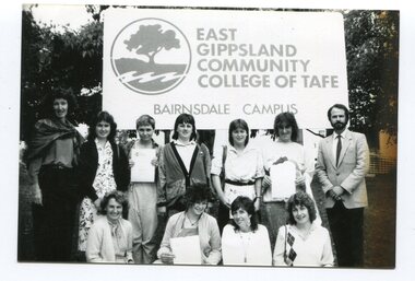
black and white photographs, Snowy River Mail, 1990
These photographs are related to adult Learning in Orbost.. They are connected to the "East Gippsland Community College of T.A.F.E. Bairnsdale Campus" The Orbost Education Centre has been in operation since 1976 and is run by a team of volunteers and paid staff. Programs and activities offered respond to the needs of the local community and the centre works closely with its community partners. It is supported by funding and goodwill from the community, state government and non-government organisations. TAFE offered adult education to those new out of school and mothers coming out of motherhood as well as others. In the photographs are: Janet Hambling; Irene Rowley; Clive Jenkins; Keith Knight; Wendy Major; Wendy Blackburn; Peter Bommer; Helen Shiels, Jeff Wilson and Peter Griebenow.These photographs are associated with Adult Learning in Orbost.Seven black / white photographs related to Adult Education in Orbost. education-adult-orbost t.a.f.e.-orbost -
 Orbost & District Historical Society
black and white photograph, C1912
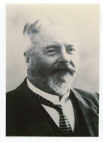
This is a photograph of Councillor H. A. Luke who represented West Riding on the Orbost Shire council from 1905 -1912. He was president in 1907 and 1912.This item is associated with the Orbost Shire Council. The shire covered an area of 9,347 square kilometres and existed from 1892 until 1994 when it became part of the East Gippsland Shire Council.A black / white head and shoulders portrait photograph of a bearded man in a suit.on back - "Cr H.A. Luke Orbost Shire"luke-h.a. orbost-shire-council -
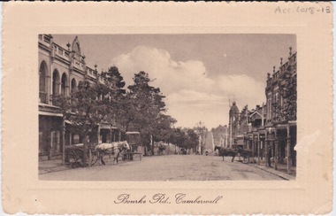 Camberwell Historical Society
Postcard - Photo postcard, Postcard of Bourke Road, Camberwell, Unknown date but postcard probably dated circa 1900 - definitely pre 1913 because in that year gas lamps were removed from main roads, intersections, also street trees in Burke Road. Also no cars are visible on the street, only horses and carriages. In March 1894 the first streets in the central city of Melbourne were lit with electricity
Undated photograph on postcard depicting horses and carts with gas lamp in the distance on Bourke Road, Camberwell. Front of postcard: 'Bourke Road, Camberwell' Back of postcard: 'Post Card' 'This side for correspondence' 'This side for address' 'Stamp here' 'Printed in Germany.' Handwritten notes '22649 $20'camberwell, bourke road -
 Orbost & District Historical Society
framed photograph, Howard D. Bulmer, 1912
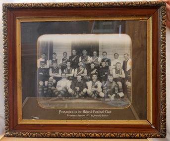
The Orbost Football Club was started in 1894. The Orbost football club players were known as the Busters and wore green and gold guernseys. An Orbost football team has participated in the East Gippsland League since the early 20th century. In 2003 in response to a dwindling population, the Snowy Rovers and Orbost Football Clubs were driven to merge into the Orbost Snowy RoversFootball clubs, through their many changes, have always been an important social fabric of the community. Sport is often regarded as an important part of life in rural Australia, contributing to community identity, sense of place, social interaction and good health.A large framed photograph of a football team - three rows, . The back row is standing, middle row seated on a bench and the front row sitting on the ground. The photograph is mounted on a dark grey buff card. The frame is an ornate brown and gold wooden one.on front below the photograph - "Presented to Orbost Football Club Premiers in 1912 by Howard D. Bulmer" -
 Orbost & District Historical Society
black and white photograph, VR Printing Works, 1975
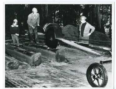
The Donchi family has ben involved in sleeper cutting in the Orbost district since the 1890s. This phootograph , one of a set of six, was taken for the Victorian Railways Magazine, August,1975, a pamphlet produced for Victorian Railways. It contains photographs and an article about Orbost as "Timber Country" and a detailed article titled, " Cutting Sleepers is a Family Business" which tells about the Donchi family.Name Associated with the timber and sleeper-cutting industry in the Orbost Region. Timber sleepers were superceded by concrete sleepers in c. 1970s. Orbost has historically been based on the timber industry, but that industry has declined considerably over the last 20 years. The number of locals involved in the timber industry has declined and many of the mills have closed. This item reflects a time when that industry was a significant contributor to the economy of the district.A black / white photograph of Pat, Ken and Alan Donchi working a large saw at a timber coupe in Orbost.on back - Pr 8767timber-industry-orbost sleeper-cutting-orbost donchi-family -
 Orbost & District Historical Society
book, 1990's
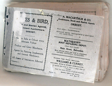
This item is probably a copy of a book produced for tourists and may have been used in the Slab Hut (Orbost visitor Information Centre). The articles contained in the booklet are dated in the 1900's.This booklet is a useful research tool.A small booklet with a laminated cover.It contains black/ white photocopies of early Orbost businesses.On front cover - handwritten "Harry Hudson"booklet-orbost-businesses -
 Melbourne Tram Museum
Pamphlet - How to drive the Fairway, VicRoads, "Now there's a better way"
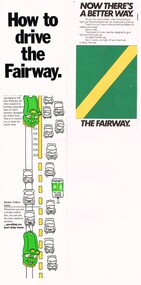
Provides the basis for segregating road traffic from tram lines at intersections and along roadways and road markings applied.Yields information about the introduction of Fairways into Melbourne tramway streets during 1983, the first legal segregation of trams from road traffic.Set of two pamphlets regarding Tram Fairways. .1 - Three-section vertical fold-out pamphlet titled "How to drive the Fairway" printed on gloss paper showing the fairway system and how its works with the various signs in a cartoon manner. Notes the Fairway system was set up in 1983 and the basis of it. Has the VicRoads logos, name, and "Victoria Growing together? logos. .2 - Three-section, horizontal format pamphlet on plain paper, titled "Now there's a better way", giving details of the system, showing drawings and how they work at intersections. Issued by the Road Traffic Authority, has the RTA logo. .3 - Newspaper cutting, titled "The old way, the Fairway" giving advanced notice of the introduction of the Fairway system and the roads impacted. Has an AEC election advertisement on the rear for the March 1983 Federal Election.fairways, cartoons, rta, vicroads, traffic control, trams, tramways -
 Orbost & District Historical Society
black and white photograph, 1920s
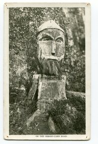
Pons asinorum was the name given to a wooden carving made by road worker Finlay Munro in the early 1920s at Boulder Creek, on the old Princess Highway, between Orbost and Cann River. The carved face was said to mock the supervising engineer after an argument about putting the road alignment across a swamp that required new bridges. The Italian workmen had advocated for a different route to avoid the need for building new bridges across the swamp. This photograph is from a set of thirteen black and white postcards in a fold-out format.This is a photograph of an iconic tourist attraction which records the woodworking skills of workers in the early 20th century. The carving is no longer there.A small black / white photograph of a face carved into a tree stump.on front at bottom - ON THE ORBOST CANN ROADwoodcarving pons-asinorum boulder-creek-east-gippsland princess-highway -
 Orbost & District Historical Society
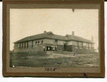
black and white photograph, C1925
This is a photograph of the Orbost High School in 1925. It has been identified by Mary Gilbert.Orbost High School / Orbost Secondary College has played a significant part in the education of senior students in the Orbost district . It is the sole senior educational institution. This photograph is representative of its history.A black / white photograph mounted on brown card. It shows a large building surrounded by bare earth. There is a group of six adults and a child standing at one corner of the building. The building is made of bricks topped by stucco and has a tiled roof. on front bottom -1925 on back - Orbost High School 1925education-orbost-high-school -
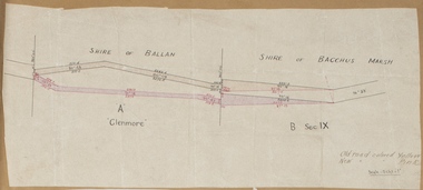 Bacchus Marsh & District Historical Society
Map, Road plan deviation near Glenmore
This plan shows a proposed deviation in the road near Glenmore. This is likely to have been the Bacchus Marsh to Ballan road. The precise date of the plan has not been established. Proposed deviations to the road near Glenmore appear in reports in the Bacchus Marsh Express newspaper through many decades, especially in the 1870s and 1880s. Glenmore is located 19 kilometers west of Bacchus Marsh.A single page paper map showing a plan for a road deviation near Glenmore Station. Scale 5 chains to 1 inch. Date of production unknown. Circa 1860s-1890s. The map is pasted into a bound volume containing 76 maps or plans in total. High resolution digital image stored on BMDHS computer network. Old road colored Yellow, New road colored Pinkroad plans, road construction, glenmore victoria maps -
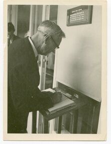 Orbost & District Historical Society
black and white photograph
Mr Alex McDonald , head of the Department of Education, signed the visitors' book at the Golden Jubilee of Orbost High School in 1962.Orbost High School / Orbost Secondary College has played a significant part in the education of senior students in the Orbost district . It is the sole senior educational institution. This item is representative of its historyA black / white photograph of a man wearing glasses signing a book.on back - "Orbost H.S. Jubilee 1962.Alex McDonald"education-orbost orbost-high-school-golden-jubilee -
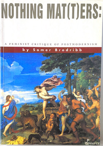 Women's Art Register
Book, Somer Brodribb, Nothing Mat(t)ers. A Feminist critique of Postmodernism, 1992
A feminist critique of post-modernism to create a new discourse in feminist theory.Book non-fictionA feminist critique of post-modernism to create a new discourse in feminist theory.structuralism, deconstructivism, theory, political art, modernism, feminism