Showing 636 items matching "river view"
-
 Hume City Civic Collection
Photograph, c Early 1990's
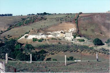
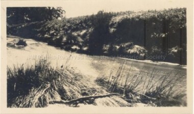
The Kaolin quarries at Bulla were an important industry in the district and supplied clay products to the Cornwell and Hoffman companies in Brunswick. The Kaolin deposits were found in the 1850's and were considered to be some of the largest in the colony.A landscape photograph of a valley with a post and wire fence and a partial view of a farm gate in the immediate foreground. A clump of native trees are on the LHS and a small grove of almond trees has been planted on the river flat. Kaolin quarry is on the hillside and two buildings can be seen on the hill top. High tension pylons are in the distance near the skyline.kaolin quarries, almond groves, bulla township, deep creek, hoffmans kaolin mine, hoffmans potteries, cornwell potteries, george evans collection -
 Hume City Civic Collection
Photograph, late 1980s
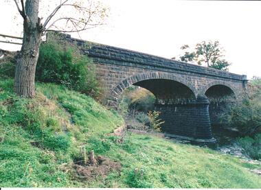
The road bridge over Jackson's Creek in Sunbury was built in 1870 and was in use until a wider bridge was built when Sunbury Road was rebuilt in the early 1970s.A coloured photograph taken from the NE side of the river bank of a complete view of the bluestone bridge at Macedon Street. The two eliptical arches and the protruding pylon as well as the underside of the bluestone span are clearly visible.transport, roads and bridges, jacksons creek, harris, thomas lascelles, george evans collection -
 Clunes Museum
Photograph
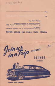
PICTURESQUE SOUVENIR OF CLUNES. A FOLDER OF 8 PHOTOS CONSISTING OF VIEWS OF CLUNES 1. 4 PANORAMAS 2. CLUNES HOSPITAL 3. OLD POST OFFICE 4. TALLAROOP RIVER CLUNES 5. 2 OF FRASER STREET, CLUNESJOIN US IN A TRIP AROUND CLUNESlocal history, photography, photographs, township & buildings -
 Nillumbik Shire Council
Mixed Media (installation): John R. NEESON (b.1956 AUS), John R Neeson, Riverbend Project, 2015
John R Neeson was a Laughing Waters Artist in Residence in 2015. During his residency Neeson made site specific trompe-l’oeil paintings and time based videos that referenced the changes of light upon the Knox architecture and the environment of Laughing Waters.Wooden easel holding an oil on board painting of the Yarra River and surrounding landscape at Laughing Waters (detailed view). Behind the painting and easel is a digital photograph of the painting and easel in situ in the landscape. The photograph is printed on aluminium. No inscriptions and markingsekphrasis 2016, neeson, easel, oil painting, yarra river, digital photograph, landscape, in situ, site specific, riverbend -
 Peterborough History Group
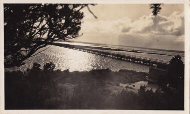
Photograph - Curdies River, Peterborough Vic, circa 1955
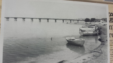
... Historic view of the river with old bridge... Historic view of the river with old bridge in the background ...Historic view of the river with old bridge in the backgroundSignificant as it shows the old Peterborough bridge, moored boats in the foreground and shoreline of the estuary at the time.Photograph of a postcardCurdies River, Peterborough Vicpeterborough 3270, curdies river, peterborough old bridge, vintage postcards, great ocean road, bridges -
 Peterborough History Group
Photograph - Photographs of The Bridge over The Curdies River
Historic views of the old wooden bridge, since replaced, and also showing the configuration of the river at that time.River and bridge integral part of Peterborough life. Digital image of two black and white photographs of the Bridge over the Curdies River, both taken from the East side showing different water levels in the rivercurdies river, curdies river bridge peterborough, peterborough victoria, great ocean road, curdies river estuary -
 Peterborough History Group
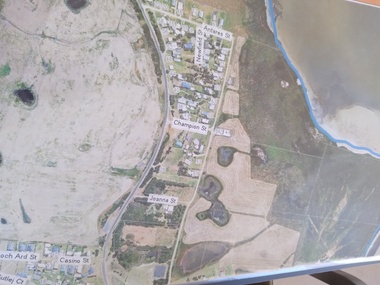
Plan - Moyne Shire Council Aerial photograph, Department of Sustainability and Environment, January 2018
... , a view of the estuary at that time. curdies river inlet ...View shows development at the time and showing the town boundary using Vicmap InformationSignificant in that it provides a record of the current state of development of the town. Also, a view of the estuary at that time.A3 size copy of an aerial view of the majority of the town with street names mentioned. curdies river inlet, peterborough, aerial view -
 Peterborough History Group
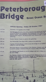
Pamphlet, Road Construction Authority, Peterborough Bridge, 1987
Printed to celebrate the official opening of the new bridge in 1987.The bridge across he river is a major access point and the old bridge had become decrepit and the construction of the new bridge was important. The official opening was a significant event.Pamphlet for the official opening of the new bridge in 1987. 2 A4 pages with a view of the old and new bridges, describing the construction of both.curdies river, great ocean road, bridges, peterborough, peterborough bridge -
 Latrobe Regional Gallery
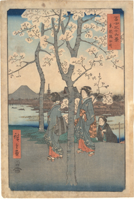
Print, HIROSHIGE, Utagawa, No. 7 From Sumida River from series "36 Views of Mt.Fuji", c. 1858 (Year of the Horse 4)
... No. 7 From Sumida River from series "36 Views of Mt.Fuji" Print ...Edo PeriodColoured woodblock printmt.fuji, sumida river -
 Malmsbury Historical Society
Photograph (Item), View Of Coliban(?) River (Near Ellis Falls?) At Malmsbury, Malmsbury c1920
... View Of Coliban(?) River (Near Ellis Falls?) At Malmsbury...-ranges Buildings - River (Coliban/?) View Of Coliban(?) River ...Buildings - River (Coliban/?) -
 Rutherglen Historical Society
Post Card Folder, Big 7 Folder, Vue Pac. 7 Detachable Post Cards of Rutherglen Victoria, c1970
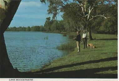
Donated by Mrs Brian Jasper.Coloured post cards in folder with views of Rutherglen and District. This one is a view of Lake MoodemereOn message side of card: "Rutherglen, Victoria. A billabong of the Murray River. A wildlife reserve incorporating camping and water sport facilities. | NCV.1050 Nucolorvue Productions Pty. Ltd."lake moodemere -
 Rutherglen Historical Society
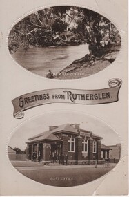
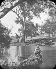
Postcard - Image, Greetings from Rutherglen, 1910 to 1912
Black and white postcard with two oval photographs with "Greetings from Rutherglen" on a banner between them. The top photograph is a view of a riverbank with a man seated on the bank fishing and smoking a pipe. The bottom one is a picture of the Post Office in Main Street.At bottom of top photograph: "The Murray River." At bottom of bottom photograph: "Post Office." Message on back of card: "To Mr Barber with every Good Wish for a merry xmas and the Happiest of New Years. From your old friends Sam & Nellie Williams. 23/12/13."murray river, rutherglen post office, christmas greetings, sam williams, nellie williams -
 Ballarat Heritage Services
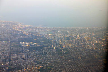
Digital Photograph, L.J. Gervasoni, Melbourne CBD and Albert Park Lake on approach Melbourne Airport, 2016
Digital Image showing an aerial view of the Melbourne Central Business District and Albert Park.aerial, melbourne, yarra river, cbd, albert park, lake, port phillip bay -
 Ballarat Heritage Services
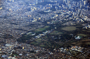
Digital Photograph, L.J. Gervasoni, Royal Park CBD and zoo from the air, 2016
Digital Image showing an aerial view of the Melbourne Central Business District and Royal Park.aerial, melbourne, yarra river, cbd, royal park, zoo -
 Ballarat Heritage Services
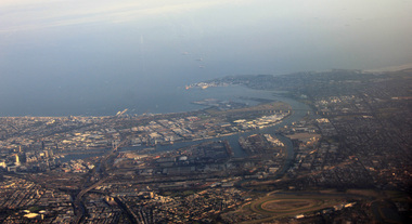
Photograph, L.J. Gervasoni, Mouth of the Yarra River from the air, 2016
Digital Image showing an aerial view of the mouth of the Yarra River from the airaerial, melbourne, mouth, yarra, river, port phillip bay, flemington, docklands, bolte bridge, west gate bridge -
 Ballarat Heritage Services
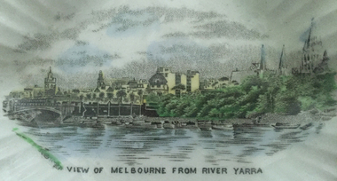
Object, Butter Plate with "View of Melbourne from River Yarra"
... Butter Plate with "View of Melbourne from River Yarra"... with an image of Melbourne from the Yarra River. Butter Plate with "View ...China butter dish with an image of Melbourne from the Yarra River. china, melbourne, yarra river -
 Ballarat Heritage Services
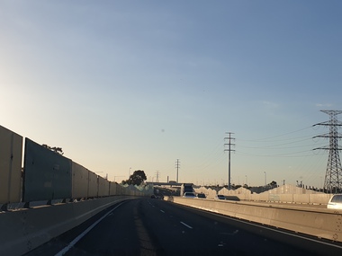
Photograph, Views of the Westgate Bridge, 29/11/2022
The Westgate Bridge spans the Yarra River giving access to Melbourne from the West. westgate bridge, melbourne, road, bridge -
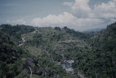 Ballarat Heritage Services
Slide, Dorothy Wickham, Loloki River, Sogeri Road, Papua New Guinea, 1958
This photograph was taken around 1958.Scanned from a coloured slideView from this sidepapua new guinea, port moresby, papuans, girl guides, dorothy kinnane, sogeri -
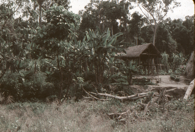 Ballarat Heritage Services
Slide, Dorothy Wickham, Hut, Brown River Road, Papua New Guinea, 1958
... Office goldfields papua new guinea papuan Brown River Road Hut ...Scanned from a coloured slideView from this sidepapua new guinea, papuan, brown river road, hut, thatch -
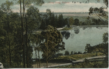 Ballarat Heritage Services
Photograph - Postcard, Gong Gong, Ballarat, 1908
Gong Gong was a locality in Ballarat East, near Fellmongers. A reservoir was built there. Situated only 10 minutes drive from the Ballarat CBD. In 2019 Gong Gong Reservoir Park is set in natural bush surrounds. There are scenics views, picnic and BBQ facilities with toilet facilities available on weekends. It is located along the Yarrowee River.photograph of Gong Gong reservoir 1908Gong Gong Ballarat - 13-4-1908 verso - note to Miss M I Wise, Gutheridge Parade, Salew. hewitt's yarrowee soap works, fellmongery, tannery, gong gong, mair street, daylesford road, o'deas, kinnane's, quin's, nestors -
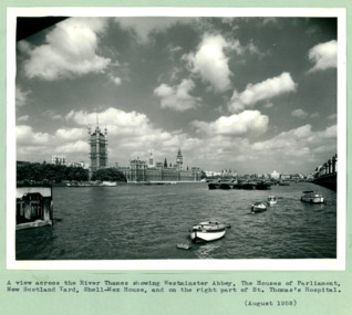 Department of Health and Human Services
A view across the River Thames showing Westminster Abbey with Big Ben in centre August 1958 - Department of Health – National Fitness Office (Sports & Recreation) – Historical Press Release Photo Collection
... A view across the River Thames showing Westminster Abbey... A view across the River Thames showing Westminster Abbey with Big ...Department of Health – National Fitness Office (Sports & Recreation) – Historical Press Release Photo - Empire Youth Day & Royals on Tour CollectionDepartment of Health – National Fitness Office (Sports & Recreation) – Historical Press Release Photo - Empire Youth Day & Royals on Tour Collection -
 Department of Health and Human Services
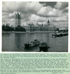
The Houses of Parliament & Big Ben viewed from the River Thames August 1957 - Department of Health – National Fitness Office (Sports & Recreation) – Historical Press Release Photo Collection
... The Houses of Parliament & Big Ben viewed from the River Thames ...Department of Health – National Fitness Office (Sports & Recreation) – Historical Press Release Photo - Empire Youth Day & Royals on Tour CollectionDepartment of Health – National Fitness Office (Sports & Recreation) – Historical Press Release Photo - Empire Youth Day & Royals on Tour Collection -
 Department of Health and Human Services
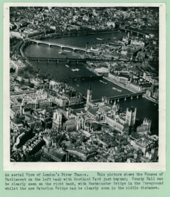
An aerial view of London's River Thames, The Houses of Parliament, and Big Ben - Department of Health – National Fitness Office (Sports & Recreation) – Historical Press Release Photo Collection
... An aerial view of London's River Thames, The Houses of... An aerial view of London's River Thames, The Houses of Parliament ...Department of Health – National Fitness Office (Sports & Recreation) – Historical Press Release Photo - Empire Youth Day & Royals on Tour CollectionDepartment of Health – National Fitness Office (Sports & Recreation) – Historical Press Release Photo - Empire Youth Day & Royals on Tour Collection -
 Department of Health and Human Services
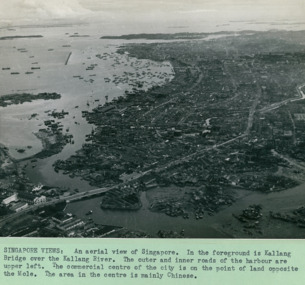
An aerial view of with the Kallang Bridge over the Kallang River in the foreground left Singapore - 3 of 3 photos - Department of Health – National Fitness Office (Sports & Recreation) – Historical Press Release Photo Collection
Department of Health – National Fitness Office (Sports & Recreation) – Historical Press Release Photo - Empire Youth Day & Royals on Tour CollectionDepartment of Health – National Fitness Office (Sports & Recreation) – Historical Press Release Photo - Empire Youth Day & Royals on Tour Collection -
 Ballarat Tramway Museum
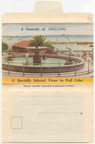
Postcard - Folder set, Nu-color-vue or Nucolorvue Productions, "A Souvenir of Geelong", 1950's
Set of 12 colour views of Geelong on a folded strip, glued within a colour printed cover, titled "A Souvenir of Geelong", printed on both sides of the strip. Booklet printed with an address area on rear. Produced by Nulcolorvue Productions, Mentone, Victoria. The rear has a slit on the rear cover that allowed the folder to be secured. On the inside of the front cover, has an introduction to Geelong, notes "modern tram and bus routes" Pictures are: 1. Gheringhap St showing Geelong City Hall and Post Office 2. The Barwon River, Geelong 3. T&G Building, Ryrie St - shows tramway overhead 4. Christ Church, Moorabool St 5. Malop St Geelong 6. Art Gallery and Park 7. St Marys Roman Catholic Cathedral 8. The Geelong Post Office with buses in background and a Safety Zone sign 9. Moorabool St Geelong - has overhead and a bar traffic light/ 10. Queens Park Geelong 11. The Waterfront at Geelong. 12. Eastern Beach Swimming Pool. Made during the early 1950's, given motor cars in the photo. trams, tramways, geelong, moorabool st, ryrie st -
 Ballarat Tramway Museum
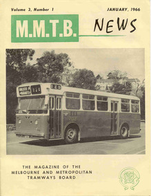
Magazine, Melbourne and Metropolitan Tramways Board (MMTB), "MMTB News", 1966
Eight issues of "MMTB News" - The Magazine of the Melbourne and Metropolitan Tramways Board. Two copies of issues 1 to 6 held. Second copy added 31/8/2004. All issues printed with an cream colour paper cover with the rest of the magazine white gloss paper. 2720.1 - Vol. 3, No. 1 - 16 pages, January 1966, with a photo of the Mark VI bus No. 702 on the front cover, notes on Traffic Congestion, motor cars and supermarkets, depot masters, engineering, bus maintenance, sports and social club news. On rear cover includes a photo of a Christmas function with past senior employees - left to right - H. R. Steains (architect), H. S. McComb (Chief Surveyor), Mr. Aird, Mr. P. M. Ireland (Rolling stock engineer), J Fisher (Civil Engineer) and H. A. Warner (Secretary) 2720.2 - Vol. 3, No. 2 - 16 pages, February 1966, with a photo of counting decimal coins, Tribute to the W2 class tram written by Norm Cross, (with photo), Hawthorn Clothing Depot, retirement of Harry Munroe, introduction of decimal currency, donation of 1B bogies to SPER, tramways band, death of Neil Olsen, sports and social club news. See btm2720i9.jpg for image of the Norm Cross photograph. 2720.3 - Vol. 3, No. 3 - 12 pages, March - April 1966, with a photo of Tramways Bowl Tournament presentation on the front cover, Recent developments in public transport in North America, Vera Cruz Mexico, cable cars at Rushworth, sports and social club news and photo of the Melbourne bogies under Sydney tram. 2720.4 - Vol. 3, No. 4 - 16 pages, May 1966, with a photo of W2 321being overhauled at Preston Workshops, change over to decimal currency for accounting machines, "Tram Driver Salutes the L class tram" - written by A. Bailey, Melbourne's New Trams, retirement of Gordon Wilson, sports and social club news. 2720.5 - Vol. 3, No. 5 - 16 pages, June 1966, with a photo of the track relaying in Camberwell Rd with Camberwell fire station in background, Melbourne cable tram routes, opening and closing dates, retirement of G. H. Box, visit of SPER members to Melbourne, memories of Malvern Depot, sports and social club news. 2720.6 - Vol. 3, No. 6 - 16 pages, July - August 1966 with a photo of the view from the St Kilda Junction signal box, more trams for Russia, retirements of 31 Employees, a contest to win an old W2, St Kilda Road Junction box - and how it works - signalling and interlocking, closure of Port Melbourne bus depot, sports and social club news. 2720.7 - Vol. 3, No. 7 - 16 pages, September - October 1966 with a photo of 610 on the Maribyrnong River Bridge, during the SPER tour, "Public Transport in Big Cities" - R. Risson - with photo - see image i10, MMTB Ambulance division, new trams, trams or buses, death of Harry Hood, Chas Samuels, retirement of Jack Ferguson, Reg Maxwell, manufacture of trackwork, cable tram working, sports and social club news. 2720.8 - Vol. 3, No. 8 - 16 pages, November - December 1966 with a photo of a wedding party on a tram (Richards / Fuller), apprenticeship training, Christmas message from the Chairman, tramway canteens, art of rostering by R. Drummond, Wattle Park Chalet, clock and instrument shop at North Fitzroy, tramways band, sports and social club news.Each issue has stamped on the front cover or inside "The Australian Railway Historical Society (S.A. Branch).trams, tramways, mmtb, sper, wattle park, port melbourne, st kilda junction, decimal currency, w2 class, l class, hawthorn -
 Bendigo Historical Society Inc.
Photograph - Glass Slide Photos of Bendigo, Early 1900s
Bendigo followed much the same pattern as Ballarat, and was not ready for an up-to-date studio until 1880 when the Bartlett Bros. (Francis and Henry) who bad conducted a successful business in Melbourne for many years opened a small studio there. It was such a success that they decided to build large modern premises, and Francis made two trips to England and the Continent for the latest ideas. In 1884 Henry died, and to replace him, Francis secured the services of Robert W. Bugg, then employed by Foster & Martin (both pupils of Batchelder's) in Collins Street, Melbourne. In that studio Bugg made some fine portraits of Anthony Trollope during the novelist's long tour of Australia. Francis Bartlett was a keen business man, and Robert Bugg was a great operator and a fine painter. Together, their success was quite outstanding. Fifteen years later Bartlett retired with a fortune, and Bugg took over the studio. Robert William Bugg, one of our leading Painter-Photographers, was born in London in 1853, and came to Melbourne when he was five years old. He became a pupil of Louis Buvelot and, in 1879, a member of the Victorian Academy of Arts. In Bendigo he gave annual exhibitions of his oils and water colours, a number of his exhibitions being officially opened by his friend Alfred Deakin. There are a number of Bugg's Paintings in the Bendigo Art Gallery. All the portraits, landscapes, buildings, and city views illustrated in "Bendigo and Vicinity, 1897", are from photographs taken by Robert Bugg. He was a clever, genial and popular soul, and his influence on the cultural life of his adopted city was considerable. He retired in 1932 and died in his early eighties.Eleven Photos of Bendigo from Glass Plate Negatives, Campaspe River at Axedale, Axe Creek, Lake Weroona, White Hills Botanical Gardens, Conseratory Gardens, Bendigo Fernery. Slides are ex Bartlett Brother Bendigo. history, bendigo, bendigo conservatory gardens, campaspe river axedale, axe creek victoria, lake weroona bendigo, white hills botanical gardens bendigo, bartlett brothers bendigo, rosalind park bendigo -
 Kew Historical Society Inc
Photograph, Marnie McLeod, Floods of the River Yarra at Kew, 1916
The donation was accompanied by the following letter from the donor: "Hi. I found these in with family photos. Taken by family as Mamie McLeod was living in Fellows Street, Kew, so would be near there. Retain (or discard) as you see fit." [Donor's name and address withheld from public view]. To gain an insight into the flood levels at Kew, it is worth reading newspaper accounts of the event. The Age published an article - Valuable Gardens Destroyed at Kew - on 25 September 1916: "VALUABLE GARDENS DESTROYED AT KEW. From the heights of Studley Park, Kew, a splendid view of the flood waters can be obtained, and yesterday afternoon, despite continuous rain, crowds of citizens assembled there to witness the spectacle. There is a vast stretch of water some 300 or 400 yards broad, above the foot bridge connecting Gipps-street, Collingwood, and Studley Park. The river is only about 3 feet from the top of the embankment connecting with the ramp of the bridge on the Studiey Park side. When the upper llood waters come down it is almost a certainty that tne embankment will be submerged and the bridge rendered impassible. Below the bridge the waters again stretch out, and have submerged all the low-lying land on the Collingwood side and invaded the back premises ot the Kodak Co., Phoenix Biscuit Factory, a tannery adjoining thereto, the Shamrock Brewery, and Chinese gardens in the vicinity. At Walmer-street-bridge, at the end of Studley Park, the low-lying land on the Kew side is covered with water to the depth of many feet. Tlie land in question is owned in a great part by Mr Frank Lavers who haa gone in for intense culture on a pretty liberal scale on both the slopes of the hill and on the river flat. On the latter he is cultivating many acres of asparagus, and has at a considerable cost spent three years in preparing the ground and installing an irrigation system, reticulated from the Yan Yean water supply. This year the asparagus was put down, and the plants were in a promising condition. Tlie flood waters are now flowing fast over the land. The crop is ruined, and three years' work and expenditure destroyed. Mr. Laver's private residence fortunately is high above flood level, but two houses he owns off Young-street have been flooded out. Having been warned in time, the tenants removed their furniture hefore the water came down to Mr. Laver's residence, where they themselves have been given accommodation in the meantime. All the river flats in East Kew are under water. One or two low-lying houses have been flooded. Chipperfield's boat shed at Willsmere is nearly covered, and some Chinese gardens in the vicinity are several feet under water."This, and the other three photographs donated of floods in Kew are believed to be the earliest in the collection. Together with our original MMBW River Yarra map showing flood levels, these items, when compared allow researchers to gain a visual perspective of the extent of the flood in 1916. Black and white photograph of flooded trees in Kew with rising dry ground in distance.Inscription on reverse in pencil: "Flood River Yarra Kew Vic"river yarra, kew, floods 1916 -
 Kew Historical Society Inc
Photograph, Marnie McLeod, Floods on the River Yarra at Kew, 1916
... withheld from public view]. To gain an insight into the flood ...The donation was accompanied by the following letter from the donor: "Hi. I found these in with family photos. Taken by family as Mamie McLeod was living in Fellows Street, Kew, so would be near there. Retain (or discard) as you see fit." [Donor's name and address withheld from public view]. To gain an insight into the flood levels at Kew, it is worth reading newspaper accounts of the event. The Age published an article - Valuable Gardens Destroyed at Kew - on 25 September 1916: "VALUABLE GARDENS DESTROYED AT KEW. From the heights of Studley Park, Kew, a splendid view of the flood waters can be obtained, and yesterday afternoon, despite continuous rain, crowds of citizens assembled there to witness the spectacle. There is a vast stretch of water some 300 or 400 yards broad, above the foot bridge connecting Gipps-street, Collingwood, and Studley Park. The river is only about 3 feet from the top of the embankment connecting with the ramp of the bridge on the Studiey Park side. When the upper llood waters come down it is almost a certainty that tne embankment will be submerged and the bridge rendered impassible. Below the bridge the waters again stretch out, and have submerged all the low-lying land on the Collingwood side and invaded the back premises ot the Kodak Co., Phoenix Biscuit Factory, a tannery adjoining thereto, the Shamrock Brewery, and Chinese gardens in the vicinity. At Walmer-street-bridge, at the end of Studley Park, the low-lying land on the Kew side is covered with water to the depth of many feet. Tlie land in question is owned in a great part by Mr Frank Lavers who haa gone in for intense culture on a pretty liberal scale on both the slopes of the hill and on the river flat. On the latter he is cultivating many acres of asparagus, and has at a considerable cost spent three years in preparing the ground and installing an irrigation system, reticulated from the Yan Yean water supply. This year the asparagus was put down, and the plants were in a promising condition. Tlie flood waters are now flowing fast over the land. The crop is ruined, and three years' work and expenditure destroyed. Mr. Laver's private residence fortunately is high above flood level, but two houses he owns off Young-street have been flooded out. Having been warned in time, the tenants removed their furniture hefore the water came down to Mr. Laver's residence, where they themselves have been given accommodation in the meantime. All the river flats in East Kew are under water. One or two low-lying houses have been flooded. Chipperfield's boat shed at Willsmere is nearly covered, and some Chinese gardens in the vicinity are several feet under water."This, and the other three photographs donated of floods in Kew are believed to be the earliest in the collection. Together with our original MMBW River Yarra map showing flood levels, these items, when compared allow researchers to gain a visual perspective of the extent of the flood in 1916. Panoramic view, believed to be looking north towards Fairfield from the Zig-Zag Bridge on the River Yarra. The inscription on the reverese identifies it as taken before 1920.Inscription on reverse in ink "(pre 1920) Flood from Zig-zag bridge Yarra River, Kew Vic."river yarra, kew, floods 1916, zig-zag bridge -
 Kew Historical Society Inc
Photograph, Marnie McLeod, Flood, River Yarra, Kew, 1916
The donation was accompanied by the following letter from the donor: "Hi. I found these in with family photos. Taken by family as Mamie McLeod was living in Fellows Street, Kew, so would be near there. Retain (or discard) as you see fit." [Donor's name and address withheld from public view]. To gain an insight into the flood levels at Kew, it is worth reading newspaper accounts of the event. The Age published an article - Valuable Gardens Destroyed at Kew - on 25 September 1916: "VALUABLE GARDENS DESTROYED AT KEW. From the heights of Studley Park, Kew, a splendid view of the flood waters can be obtained, and yesterday afternoon, despite continuous rain, crowds of citizens assembled there to witness the spectacle. There is a vast stretch of water some 300 or 400 yards broad, above the foot bridge connecting Gipps-street, Collingwood, and Studley Park. The river is only about 3 feet from the top of the embankment connecting with the ramp of the bridge on the Studiey Park side. When the upper llood waters come down it is almost a certainty that tne embankment will be submerged and the bridge rendered impassible. Below the bridge the waters again stretch out, and have submerged all the low-lying land on the Collingwood side and invaded the back premises ot the Kodak Co., Phoenix Biscuit Factory, a tannery adjoining thereto, the Shamrock Brewery, and Chinese gardens in the vicinity. At Walmer-street-bridge, at the end of Studley Park, the low-lying land on the Kew side is covered with water to the depth of many feet. Tlie land in question is owned in a great part by Mr Frank Lavers who haa gone in for intense culture on a pretty liberal scale on both the slopes of the hill and on the river flat. On the latter he is cultivating many acres of asparagus, and has at a considerable cost spent three years in preparing the ground and installing an irrigation system, reticulated from the Yan Yean water supply. This year the asparagus was put down, and the plants were in a promising condition. Tlie flood waters are now flowing fast over the land. The crop is ruined, and three years' work and expenditure destroyed. Mr. Laver's private residence fortunately is high above flood level, but two houses he owns off Young-street have been flooded out. Having been warned in time, the tenants removed their furniture hefore the water came down to Mr. Laver's residence, where they themselves have been given accommodation in the meantime. All the river flats in East Kew are under water. One or two low-lying houses have been flooded. Chipperfield's boat shed at Willsmere is nearly covered, and some Chinese gardens in the vicinity are several feet under water."This, and the other three photographs donated of floods in Kew are believed to be the earliest in the collection. Together with our original MMBW River Yarra map showing flood levels, these items, when compared allow researchers to gain a visual perspective of the extent of the flood in 1916. Small black and white photograph of flooded trees in Kew.Inscription on reverse in ink "Flood R. Yarra Kew Vicriver yarra, kew, floods 1916