Showing 4072 items
matching road plans
-
 Eltham District Historical Society Inc
Photograph - Aerial Photograph, Landata, Eltham; Crown Allotment 15, Section 5, Parish of Nillumbik (Stokes Orchard Estate), Sep. 1991
Centred on present day Diosma Rd, Stokes Pl, Nyora Rd and Eucalyptus Rd Historic Aerial Imagery Source: Landata.vic.gov.au Aerial Photo Details: Project No :2072 Project : MELBOURNE PROJECT Run : 13 Frame : 119 Date : 09/1991 Film Type : COL Camera : RC10 Flying Height : 8300 Scale : 15000 Film Number : 4419 GDA2020 : 37°43'07"S, 145°09'35"E MGA2020 : 337812, 5823811 (55) Melways : 22 B6 (ed. 42) A History of the Development of Crown Allotment 15, Section 5, Parish of Nillumbik – Stokes Orchard Crown Allotment 15, Section 5, Parish of Nillumbik (CA15) is a square allotment of 158 acres or approximately a quarter of a square mile. It lies just beyond the eastern end of Pitt Street, south of Nyora Road to the northern end of Eucalyptus Road and extends east from Eucalyptus Road to Reynolds Road. The topography of CA15 is generally steep, sloping up to a hill near the centre of the land, the ridgeline passing through the properties along the southern side of Diosma Road. Eucalyptus Road is a straight north-south road with its northern end at the north west corner of CA15. Until the end of the 1970s this road was an un-named Government Road and was largely not open to traffic. With residential development in the 1970s the road was constructed, and the council allocated the name obviously in recognition of the predominant species of the local bushland. CA15 was purchased from the Crown by George D’Arley Boursiquot, a prominent Melbourne printer, on 28th October 1852. On November 23, 1922, former Member for Gippsland and Melbourne Real Estate Agent, Hubert Patrick Keogh purchased the allotment then sold it March 13, 1925, to local farmer, Robert David Taylor, a former Shire of Eltham Councillor (1911-1920) and Shire President (1919). Taylor had extensive land holdings stretching west towards Bible Street and Main Road. The Taylor home was situated at the top of the hill in Bible Street at present day 82 Bible Street. At the time of Taylor’s purchase in 1925, CA15 was subdivided into 48 lots that could be described as small rural properties or large residential lots. A typical lot size was one hectare or 2.5 acres. The subdivision created two roads, Nyora Road, and Diosma Road, each following an irregular alignment between Eucalyptus and Reynolds Roads. However, the lots were not sold off separately nor were the roads constructed. The land effectively remained as one parcel for many further years. Robert David Taylor died November 30, 1934, and probate was granted to his son of the same name, Robert David Taylor of Bible Street, Salesman and William McLelland Vance Taylor of 73 Emmeline Street, Northcote, Clerk, with the transfer of the land into their names on July 8, 1935. Frank Stokes worked as a qualified accountant at Kennons leather factory in Burnley, while living at 1 Thomas Street, Mitcham. He suffered from migraines and wanted to return to working the land (he had previously worked on farms and orchards since coming to Australia from England in 1926, both in WA and Vic.). He first travelled to the district by train in July 1942 to find land with the intention to establish an orchard. By chance he met Arthur Bird of Bird Orchard (bounded by Pitt Street, Eucalyptus Road, and Wattle Grove) and they got talking over their common interest. Arthur put Frank up for the night and pointed out the land, 158 acres- part of the Taylor Estate- £900, Crown Allotment 15, Section 5, Parish of Nillumbik (CA15) somewhat diagonally opposite Bird Orchard. Stokes applied through the Riverina Agency to purchase the land who in turn applied for permission from Canberra to sell as there was a new government regulation introduced during the Second World War banning land sales except for immediate production. Stokes obtained a loan on his Mitcham house of £600 @ 5% and paid £450 deposit with quarterly payments of £15 spread over 5 years. Stokes was assisted and advised by Arthur Bird who farmed the neighbouring orchard. In early 1943 Stokes took possession and would catch the train out to Eltham on Fridays after work and began building a hut on the corner of Nyora Road and the Government Road (Eucalyptus Road) for shelter and to lock up tools. He established an orchard on the central western part of the land through the centre of which ran a natural waterway (part of the present-day linear park) and was able to pay a neighbour (Hawkins) to help with clearing and fencing 25 acres, and with a horse and single furrowed plough, planted approximately 2,500 fruit trees - cherries, peaches, plums, almonds, pears, apricots and lemons as well as a few apples and oranges; a massive task. Aerial photographs from the 1940s through to the 1990s clearly show the orchard with most of the larger CA15 site remaining as natural bushland. A huge problem was hares and rabbits eating all the new buds off the tiny trees. As well as laying poison he painted the trees with a mixture of cow manure and lime, often working by moonlight. Procurement of wire and wire netting was difficult because of the war but after much effort he obtained a permit from the Agricultural Department for supplies in March 1944. In February 1945 Stokes applied for a permit to build a “packing shed” as no house building was allowed. It was to be 33 feet x 21 feet and cost £312. It was constructed mostly from second-hand materials, which were hard to obtain, especially iron for roofing. Stokes finished work at Kennons on October 31, 1945, and in March 1946 he sold the family home at Mitcham for £1,230 plus £170 for furniture. On May 15, 1946, title to the CA15 property was issued to Frank Howard Alfred Stokes, Orchardist and Gladys Ethel Stokes, Married Woman, both of Pitt Street, Eltham. The family of five then moved into the very unfinished “packing shed” at Eltham, which was a struggle to weatherproof. Eventually rooms were divided off and lined with hessian bags and whitewashed. Their income was firewood (cut and sold), selling rockery stones and cut Sweet Bursaria. (It was discovered during the 1940s that Sweet Bursaria contained the sunscreen compound Aesculin. The RAAF utilised this compound from Sweet Bursaria during WW2 for pilots and gunners.) The orchard’s first fruit sale was a half-case of Le Vanq peaches in December 1947 for the price of 8 shillings. In 1956 plans for house were drawn and Glen Iris bricks purchased (1956 Olympic Rings variant). The building of the house commenced in 1957 - 12 feet of original packing shed was removed – and was completed in 1959. Water was connected from newly built pressure storage on the property at the end of 1959 and the electricity connection for the first time at 3pm on April 29, 1960. The house remains to present day (somewhat modified) at 1 Nyora Road, home to Nyora Studio Gallery. On occasions, spare remnants of the 1956 bricks have been known to be unearthed in gardens on the estate as they were utilised by Frank Stokes to fill in rabbit holes. On May 26, 1950, a parcel of land was compulsorily acquired by the Melbourne and Metropolitan Board of Works on the hilltop to establish an easement for a high-level service reservoir to augment Eltham’s water supply. The project also included pipe tracks for the necessary water mains. The reservoir has now been superseded by higher level water tanks east of Reynolds Road and its former site is now a public reserve. On November 27, 1964, the State Electricity Commission served notice to compulsorily acquire a further parcel through the eastern part of the land for a major electricity transmission line that augmented supply from the La Trobe Valley to Melbourne. The easement was registered February 11, 1966. The easement was widened July 18, 1969 for a second transmission line to be constructed. In 1971 Melbourne Metropolitan Planning Scheme amendments adopted Nyora Road as the boundary between a residential zone to the north and a rural zone to the south. This determined the future development of the land. In the mid-1970s the Shire of Eltham divided the orchard into numerous rate-able parcel lots, the 48 lots having been established in 1925 and the subsequent rates assessment proved unsustainable for Stokes. He commenced selling lots outside the boundary of the orchard, north of Diosma and South of Nyora. However shortly later the land between Nyora and Diosma Roads and west of the electricity easement was sold and subdivided into residential lots, a housing development by Macquarie Builders and marketed as the Stokes Orchard Estate. New streets were created, and most were named after trees, although one, Stokes Place, commemorates the former owners. The development was undertaken in two stages; Stage 1 (1975) encompassing Scarlet Ash Court, Ironbark Close and Peppermint Grove bounded by Nyora and Eucalyptus roads and Stage 2 (1978) encompassing Stokes Place, Orchard Way, The Crest and The Lookout bound by Nyora and Diosma roads. The developer, Macquarie Builders went bankrupt shortly after the release of Stage 2 leaving many purchasers to fend for themselves and arrange for their own independent builders. There were also difficulties with sewerage for the land immediately south of Diosma Road and so the conventional residential lots were abandoned in favour of larger lots. The development of Orchard Way, The Crest and The Lookout did not proceed as planned and the proposed lots were incorporated into five-acre parcels instead. These included a low-density group housing development by the Graves family and the award winning Choong House (1983) with Gordon Ford developed garden immediately next door situated on the ridge of the hill nestled amongst the original bush, Eucalypt trees and Sweet Bursaria. In 1994, Nillumbik Shire Council applied Significant Environment and Significant Landscape overlays upon the properties on the south side of Diosma Road to ensure protection of this natural bush garden environment. With the arrival of the sewer along Diosma Road in the 1990s, most of these five-acre parcels have since been subdivided multiple times. The Choong house presently sits on a 2.7-acre property, which in 2022 Nillumbik Council nominated for Cultural Significance Heritage protection and is considered potentially significant at State level. The Stokes family were also associated with the Eltham Christian Church. In the 1970s this church had met in temporary premises in Eltham. Lots of the original 1925 subdivision remained south of Nyora Road and a number of these lots were utilized for the Eltham Christian School, which was established by the Eltham Christian Church in 1981. The school operated on this site until 2000. The premises are now used by The Vine Baptist Church. By the mid-1980s the whole of CA15 had been developed for residential and school purposes, except for the sections north of Diosma Road and between the transmission lines and Reynolds Road. Sewerage issues had been resolved for the section north of Diosma Road and in 1987 it was in the process of being subdivided into residential lots. The development coincided with the discovery of colonies of the rare and endangered Eltham Copper Butterfly on the site. This resulted in a community and political campaign to save the butterfly habitat. With the co-operation of the land developer the subdivision was altered to create two bushland reserves in the critical butterfly habitat areas. In the late 1980s the State Government was investigating options for establishing a metropolitan ring road link between Diamond Creek and Ringwood. The chosen route was adjacent to Reynolds Road and so this created a freeze on development of CA15 between Reynolds Road and the electricity easement. The ring road proposal was eventually abandoned, and this part of the land was subdivided into low density residential lots. Diosma Road has been discontinued at the electricity easement and the eastern part incorporated into View Mount Court with access from Reynolds Road. The whole of CA15 has now been developed for residential or associated purposes, ranging from conventional density to quite low density south of Nyora Road. Some remnants of the orchard remain, a few cherry trees on the Graves property and a lone apple tree in Stokes Place. The butterfly reserves comprise significant areas of remnant bushland. Linear reserves through the estate link with central Eltham via the Woodridge linear reserve and with Research along the electricity easement. CA15 as it exists today has a complicated history of rural use, Government acquisition, urban development, and community action. References: • “Stokes Orchard, an incomplete history”; Russell Yeoman with Doug Orford • Correspondence, Beryl Bradbury (nee Stokes) • Aerial Photographs, 1931-1991, Landata (landata.vic.gov.au) • Certificate of Title, Vol. 4930 Fol. 985900 • Plan Number LP 10859 aerial photo, diosma road, eltham copper butterfly, eucalyptus road, ironbark close, nyora road, peppermint grove, peter & elizabeth pidgeon collection, power transmission lines, reynolds road, scarlet ash court, stokes orchard estate, stokes place, woodridge estate, frank stokes -
 Eltham District Historical Society Inc
Document - Certificate of Title, Landata, Vol. 4930 Fol. 985900, Crown Portion 15 Section 5, Parish of Nillumbik, County of Evelyn, 1925
(Cancelled) Certificate of Title originally issued for Crown Portion 15, Section 5 to Robert David Taylor, of Eltham, County of Evelyn, Farmer, 13 March 1925. It is with this title that the land allotment was subdivided into 48 lots. The title shows the issuance to Robert David Taylor with encumbrance placed upon it by immediate former owner, Hugh Patrick Keogh, a former member for Gippsland and Melbourne Real Estate Agent. Following Taylor's death in 1934 the title passes to his Executors, sons Robert David Taylor of Bible Street, Eltham and William McLelland Vance Taylor of Northcote. The property is then sold to Frank Stokes who develops the Stokes Orchard. Compulsory acquisitions by the Melbourne Metropolitan Board of Works and State Electricity Commission show provisions of easemenst for town water supply and high voltage power transmission lines. Subsequent lots are then sold off with the development of the Stokes Orchard Estate residential development in the mid to late 1970s. A History of the Development of Crown Allotment 15, Section 5, Parish of Nillumbik – Stokes Orchard Crown Allotment 15, Section 5, Parish of Nillumbik (CA15) is a square allotment of 158 acres or approximately a quarter of a square mile. It lies just beyond the eastern end of Pitt Street, south of Nyora Road to the northern end of Eucalyptus Road and extends east from Eucalyptus Road to Reynolds Road. The topography of CA15 is generally steep, sloping up to a hill near the centre of the land, the ridgeline passing through the properties along the southern side of Diosma Road. Eucalyptus Road is a straight north-south road with its northern end at the north west corner of CA15. Until the end of the 1970s this road was an un-named Government Road and was largely not open to traffic. With residential development in the 1970s the road was constructed, and the council allocated the name obviously in recognition of the predominant species of the local bushland. CA15 was purchased from the Crown by George D’Arley Boursiquot, a prominent Melbourne printer, on 28th October 1852. On November 23, 1922, former Member for Gippsland and Melbourne Real Estate Agent, Hubert Patrick Keogh purchased the allotment then sold it March 13, 1925, to local farmer, Robert David Taylor, a former Shire of Eltham Councillor (1911-1920) and Shire President (1919). Taylor had extensive land holdings stretching west towards Bible Street and Main Road. The Taylor home was situated at the top of the hill in Bible Street at present day 82 Bible Street. At the time of Taylor’s purchase in 1925, CA15 was subdivided into 48 lots that could be described as small rural properties or large residential lots. A typical lot size was one hectare or 2.5 acres. The subdivision created two roads, Nyora Road, and Diosma Road, each following an irregular alignment between Eucalyptus and Reynolds Roads. However, the lots were not sold off separately nor were the roads constructed. The land effectively remained as one parcel for many further years. Robert David Taylor died November 30, 1934, and probate was granted to his son of the same name, Robert David Taylor of Bible Street, Salesman and William McLelland Vance Taylor of 73 Emmeline Street, Northcote, Clerk, with the transfer of the land into their names on July 8, 1935. Frank Stokes worked as a qualified accountant at Kennons leather factory in Burnley, while living at 1 Thomas Street, Mitcham. He suffered from migraines and wanted to return to working the land (he had previously worked on farms and orchards since coming to Australia from England in 1926, both in WA and Vic.). He first travelled to the district by train in July 1942 to find land with the intention to establish an orchard. By chance he met Arthur Bird of Bird Orchard (bounded by Pitt Street, Eucalyptus Road, and Wattle Grove) and they got talking over their common interest. Arthur put Frank up for the night and pointed out the land, 158 acres- part of the Taylor Estate- £900, Crown Allotment 15, Section 5, Parish of Nillumbik (CA15) somewhat diagonally opposite Bird Orchard. Stokes applied through the Riverina Agency to purchase the land who in turn applied for permission from Canberra to sell as there was a new government regulation introduced during the Second World War banning land sales except for immediate production. Stokes obtained a loan on his Mitcham house of £600 @ 5% and paid £450 deposit with quarterly payments of £15 spread over 5 years. Stokes was assisted and advised by Arthur Bird who farmed the neighbouring orchard. In early 1943 Stokes took possession and would catch the train out to Eltham on Fridays after work and began building a hut on the corner of Nyora Road and the Government Road (Eucalyptus Road) for shelter and to lock up tools. He established an orchard on the central western part of the land through the centre of which ran a natural waterway (part of the present-day linear park) and was able to pay a neighbour (Hawkins) to help with clearing and fencing 25 acres, and with a horse and single furrowed plough, planted approximately 2,500 fruit trees - cherries, peaches, plums, almonds, pears, apricots and lemons as well as a few apples and oranges; a massive task. Aerial photographs from the 1940s through to the 1990s clearly show the orchard with most of the larger CA15 site remaining as natural bushland. A huge problem was hares and rabbits eating all the new buds off the tiny trees. As well as laying poison he painted the trees with a mixture of cow manure and lime, often working by moonlight. Procurement of wire and wire netting was difficult because of the war but after much effort he obtained a permit from the Agricultural Department for supplies in March 1944. In February 1945 Stokes applied for a permit to build a “packing shed” as no house building was allowed. It was to be 33 feet x 21 feet and cost £312. It was constructed mostly from second-hand materials, which were hard to obtain, especially iron for roofing. Stokes finished work at Kennons on October 31, 1945, and in March 1946 he sold the family home at Mitcham for £1,230 plus £170 for furniture. On May 15, 1946, title to the CA15 property was issued to Frank Howard Alfred Stokes, Orchardist and Gladys Ethel Stokes, Married Woman, both of Pitt Street, Eltham. The family of five then moved into the very unfinished “packing shed” at Eltham, which was a struggle to weatherproof. Eventually rooms were divided off and lined with hessian bags and whitewashed. Their income was firewood (cut and sold), selling rockery stones and cut Sweet Bursaria. (It was discovered during the 1940s that Sweet Bursaria contained the sunscreen compound Aesculin. The RAAF utilised this compound from Sweet Bursaria during WW2 for pilots and gunners.) The orchard’s first fruit sale was a half-case of Le Vanq peaches in December 1947 for the price of 8 shillings. In 1956 plans for house were drawn and Glen Iris bricks purchased (1956 Olympic Rings variant). The building of the house commenced in 1957 - 12 feet of original packing shed was removed – and was completed in 1959. Water was connected from newly built pressure storage on the property at the end of 1959 and the electricity connection for the first time at 3pm on April 29, 1960. The house remains to present day (somewhat modified) at 1 Nyora Road, home to Nyora Studio Gallery. On occasions, spare remnants of the 1956 bricks have been known to be unearthed in gardens on the estate as they were utilised by Frank Stokes to fill in rabbit holes. On May 26, 1950, a parcel of land was compulsorily acquired by the Melbourne and Metropolitan Board of Works on the hilltop to establish an easement for a high-level service reservoir to augment Eltham’s water supply. The project also included pipe tracks for the necessary water mains. The reservoir has now been superseded by higher level water tanks east of Reynolds Road and its former site is now a public reserve. On November 27, 1964, the State Electricity Commission served notice to compulsorily acquire a further parcel through the eastern part of the land for a major electricity transmission line that augmented supply from the La Trobe Valley to Melbourne. The easement was registered February 11, 1966. The easement was widened July 18, 1969 for a second transmission line to be constructed. In 1971 Melbourne Metropolitan Planning Scheme amendments adopted Nyora Road as the boundary between a residential zone to the north and a rural zone to the south. This determined the future development of the land. In the mid-1970s the Shire of Eltham divided the orchard into numerous rate-able parcel lots, the 48 lots having been established in 1925 and the subsequent rates assessment proved unsustainable for Stokes. He commenced selling lots outside the boundary of the orchard, north of Diosma and South of Nyora. However shortly later the land between Nyora and Diosma Roads and west of the electricity easement was sold and subdivided into residential lots, a housing development by Macquarie Builders and marketed as the Stokes Orchard Estate. New streets were created, and most were named after trees, although one, Stokes Place, commemorates the former owners. The development was undertaken in two stages; Stage 1 (1975) encompassing Scarlet Ash Court, Ironbark Close and Peppermint Grove bounded by Nyora and Eucalyptus roads and Stage 2 (1978) encompassing Stokes Place, Orchard Way, The Crest and The Lookout bound by Nyora and Diosma roads. The developer, Macquarie Builders went bankrupt shortly after the release of Stage 2 leaving many purchasers to fend for themselves and arrange for their own independent builders. There were also difficulties with sewerage for the land immediately south of Diosma Road and so the conventional residential lots were abandoned in favour of larger lots. The development of Orchard Way, The Crest and The Lookout did not proceed as planned and the proposed lots were incorporated into five-acre parcels instead. These included a low-density group housing development by the Graves family and the award winning Choong House (1983) with Gordon Ford developed garden immediately next door situated on the ridge of the hill nestled amongst the original bush, Eucalypt trees and Sweet Bursaria. In 1994, Nillumbik Shire Council applied Significant Environment and Significant Landscape overlays upon the properties on the south side of Diosma Road to ensure protection of this natural bush garden environment. With the arrival of the sewer along Diosma Road in the 1990s, most of these five-acre parcels have since been subdivided multiple times. The Choong house presently sits on a 2.7-acre property, which in 2022 Nillumbik Council nominated for Cultural Significance Heritage protection and is considered potentially significant at State level. The Stokes family were also associated with the Eltham Christian Church. In the 1970s this church had met in temporary premises in Eltham. Lots of the original 1925 subdivision remained south of Nyora Road and a number of these lots were utilized for the Eltham Christian School, which was established by the Eltham Christian Church in 1981. The school operated on this site until 2000. The premises are now used by The Vine Baptist Church. By the mid-1980s the whole of CA15 had been developed for residential and school purposes, except for the sections north of Diosma Road and between the transmission lines and Reynolds Road. Sewerage issues had been resolved for the section north of Diosma Road and in 1987 it was in the process of being subdivided into residential lots. The development coincided with the discovery of colonies of the rare and endangered Eltham Copper Butterfly on the site. This resulted in a community and political campaign to save the butterfly habitat. With the co-operation of the land developer the subdivision was altered to create two bushland reserves in the critical butterfly habitat areas. In the late 1980s the State Government was investigating options for establishing a metropolitan ring road link between Diamond Creek and Ringwood. The chosen route was adjacent to Reynolds Road and so this created a freeze on development of CA15 between Reynolds Road and the electricity easement. The ring road proposal was eventually abandoned, and this part of the land was subdivided into low density residential lots. Diosma Road has been discontinued at the electricity easement and the eastern part incorporated into View Mount Court with access from Reynolds Road. The whole of CA15 has now been developed for residential or associated purposes, ranging from conventional density to quite low density south of Nyora Road. Some remnants of the orchard remain, a few cherry trees on the Graves property and a lone apple tree in Stokes Place. The butterfly reserves comprise significant areas of remnant bushland. Linear reserves through the estate link with central Eltham via the Woodridge linear reserve and with Research along the electricity easement. CA15 as it exists today has a complicated history of rural use, Government acquisition, urban development, and community action. References: • “Stokes Orchard, an incomplete history”; Russell Yeoman with Doug Orford • Correspondence, Beryl Bradbury (nee Stokes) • Aerial Photographs, 1931-1991, Landata (landata.vic.gov.au) • Certificate of Title, Vol. 4930 Fol. 985900 • Plan Number LP 10859 neil webster collection, diosma road, eltham copper butterfly, eucalyptus road, ironbark close, nyora road, peppermint grove, power transmission lines, reynolds road, scarlet ash court, stokes orchard estate, stokes place, woodridge estate, frank stokes, certificate of title -
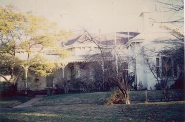 Glen Eira Historical Society
Photograph - Lirrewa
Two items all related to Lirrewa 1/Three copies of auctioneer’s brochure for sale of Lirrewa showing a sketch and floor plan. Auctioneer GA Thomson & Co 2/Colour photograph of Lirrewa, c 1983, undated and unsignedlirrewa, lirrewa grove, stables, brooks gl, thomson ga & co, estate agents, murrumbeena road, murrumbeena, lofts, slate tiles, house names, flats -
 Glen Eira Historical Society
Drawing - St. Mary’s Church, Caulfield
Two roneoed copies of St. Mary’s Anglican Church dated 15/05/1988. Ecumenical order of service for Australia’s Bicentenary. Four articles of ephemera relating to St. Mary’s Church of England. Printed leaflet in regards to a proposed meeting of the St. Mary’s Master Plan presentation circa 2000 for St. Mary’s Anglican Church.st. mary’s church, choir, ashton e. madame, robertson l., eggleston egan, bakewell guy, latham freda, allan’s, music stores, merton, orrong road, caulfield, merton dramatic society, glen eira road -
Glen Eira Historical Society
Letter - St. Stephen’s Presbyterian Church, Caulfield
Two documents regarding the historical significance of St. Stephen’s Church, 158 Balaclava Road Caulfield. The first document is correspondence dated 25/09/1990 from the National Trust informing the City of Caulfield of the inclusion of the church on the National Trust Register. The second document is a photocopy of the Caulfield Conservation Study by Andrew Ward dated February 1994. It includes an unclear front view photograph, references and recommends planning scheme control.city of caulfield, caulfield, caulfield north, balaclava road, kooyong road, st. stephen’s church, presbyterian church, uniting church, ward andrew, kinross george, currie george, haddon robert, architects, builders, churches, caulfield conservation study, national trust register, gothic revival architecture, architectural features, architectural styles, heritage studies, patios, windows, registers, symbols, fundraising events, religious ceremonies, religious groups -
Glen Eira Historical Society
Plan - St Patrick’s Roman Catholic Church, Murrumbeena
There is a photocopy of the commemorating booklet for the blessing and opening of St Patrick’s Memorial Catholic Church Murrumbeena on 15 August 1963. It also includes a brief history of the parish, a plan of the church and a sketch of the church exterior. Second there is an unattributed undated research note of the memorial stones for St Patrick’s Catholic Church and school Murrumbeena. Third is an unattributed, undated handwritten notes on St Patrick’s School buildings regarding teaching sisters and dates when additional classrooms were built. The fourth document is a six page brochure seeking donations from parishioners to commence on 10/04/1966. It includes the church’s financial statement, a picture of the church exterior as the cover and two photographs of the reverends. Inside the booklet.glen huntly, religious services, tweedy e. v, cremin patrick rev., murrumbeena, fox bishop, parish, north road, ellis robert o, clergy, malvern east, memorials, parish of ormond, east boundary road, dalny road, rovira william rev, quillinan james rev, church furniture, murrumbeena road., memorial stone, mannix daniel archbishop, pollard k, catholic church, m.p arbory and co., st patrick’s roman catholic church murrumbeena -
Glen Eira Historical Society
Book - St Peter's Catholic Church, Bentleigh East
The Growing Harvest Is A Book That Continues The History Of St Peter's Parish, Bentleigh East During 1974 – 1983, Written By Bernie O’Brien. It Includes The Opening Of The New Church, The Foundations Of The Parish, Parish Developments, St Peter's School Church Community Related Aids & Groups Including All Previous Parish Priests.st peter's catholic church, guiney john, bentleigh east, bentleigh parish, heriot maurice fr, centre road, st paul's, o’brian bernie, bignell road, parish of st peter's, mannix daniel dr, connie street, the living harvest, whitehouse ray fr, new church, kennedy james joseph, cooper julie, stanhope wayne fr, bennett maureen, o’connor gerald fr, kathleen sr, chambers greg fr, murphy brendan, bourke colin fr, o’sullivan tim fr, maloney des fr, crawford fr, mckenna fred fr, bowd mr & mrs, livingstone stan, reed john, smith patricia sr, doolan fr, de marzi led fr, nolan m fr, handley dennis fr, boyer peter, hogan chris, reynolds mark fr, reynolds greg fr, dillon kevin fr, hayes brendan rev., shannon sue sr., family planning, emergency home help, moorabbin hospital, lay ministers, school bus, bingo, catholic family welfare bureau, liturgy, scout hall, bottle drive, moongala drop-in centre, the lighthouse, sacrificial offering, mayor of moorabbin, ecumenical civil service, rite of christian initiation for adults, big brother little brother, st peter's school, ash wednesday bushfires, lightning premiership, safety house program, salesian society, cappuchin fathers, jesuits, diocesan seminary, order of our lady of the sacret heart, sisters of our lady of the sacret heart, kennedy margaret sr., laidler terry fr, noreen sr., cochrane james, leach martin fr, reynolds greg, kooy van fr, lazzaro maria sr., coakley fr, maloney desmond fr, crawford malcolm fr, browne joseph fr, lilley con, corpus christi, cabrini sisters, mission cross, the rite of dedication, statue of st peter, the tree of life, the relic of st olivier, plunkett, holy name society, st vincent de paul, the children of mary, the legion of mary, parish finance committee, the anchor club -
Glen Eira Historical Society
Article - Third Church of Christ, Scientist, Elsternwick
5 Articles about the building which used to be Third Church of Christ, Scientist Elsternwick. The first one is an article from leader newspaper dated 27 July 2010 discussing the plan to convert former Christian Science Church and latterly Buddhist organisation into apartments. The second article is from Leader Newspaper dated 10 August 2010, commenting on disruptions that might occur with redevelopment. Third article is from Caulfield Leader, 07/09/2010. The article is on continuing discussion on proposed plans for the building which previously was a historic church. Also mentioned, residence’s concern and complains about the plan. The fourth article from Caulfield/ Port Phillip Leader, 24/05/2011, mainly talks about similar development at 221 -229 Glen Huntly Road. It also touches the subject of 233 – 147 Glen Huntly Road and 12 – 14 Ripon Grove as well. It is written that VCAT allowed the development of 10 storey building after overturning council decision. The fifth article is from Melbourne Bayside Weekly, 28/03/2012. It talks about the history of The Church of Christ, Scientist and about the old church building that still stands.ripon grove, gordon street, contour consultant, glen eira, historic sites, buddhist clubs and associations, elsternwick, glen huntly road, church, wait peter, wright kristen, kate ms, sinclair street, soka gakkaii, local government, local officials and employees, mc combie street, david street, ward camden, holden lars., connellan rose, connellan cathlea, connellan marilyn, third church of christ scientist elsternwick, heritage victoria, victorian civil and administration tribunal, eddy mary baker, clifton andrew, sammon jason, di paolo lucy, robinson andrew, ling jenny, church of christ scientist -
Glen Eira Historical Society
Letter - Trinity Congregational Church, Glen Huntly
Roneod letter from the National Trust, Victoria, to the Congregational Union of Victoria. The correspondence gives notification that the church has been placed in the classified List and should be preserved. Dated 20/03/1973. Correspondence from Department of Planning Victoria, advising the Caulfield Historical Society, that the H. B. Council has chosen not to recommend the building for addition to the Historic Buildings Register Dated 08/10/1982. Extracted From Caulfield Conservation Study By Andrew Ward Dated January 1995 Describing Trinity Congregational Church. Includes Brief History Of The Church And Description Of Architectural Features.trinity congregational church., moran b., preston joane, grange road, caulfield., historic buildings council, glen huntly, hart trevor, grey karen, timber houses, filbert street, old calendar greek, primitive methodists, caulfield south, orthodox church, el nido grove, lyons street, porches, market gardens., gothic style, congregationalists, ward andrew, architectural features, architectural styles -
 Glen Eira Historical Society
Plan - Trinity Congregational Church, Glen Huntly
Black and white photograph donated in 2002 by Bob Sinclair. Shows front porch. Hand drawn plan of rear interior of Trinity Congregational Church. Shows plan of doors and windows as well as circular leadlight window and vestry doors. Not Known by whom or date.trinity congregational church, primitive methodist church., grange road., glen huntly, sinclair bob -
Glen Eira Historical Society
Plan - Uniting Church Archives, Orrong Road, 78-66, Elsternwick
Six documents including plan and correspondence between Elsternwick Methodist Church, Public Health Department and Beddoe Pty Ltd concerning the application to make alterations and additions including the erecting of a brick kindergarten from 30/07/1937 to 03/03/1939.elsternwick methodist church, orrong road, beddoe pty ltd., halls, kindergarten, robinson c.h., briggs james r., beddoe f.g., charlesworth a.c., methodist church trust, town clerks, hoddle street -
Glen Eira Historical Society
Plan - Caulfield State School No. 773
Three documents about this school covering: A 20 page booklet, (2 copies) of historical notes on Caulfield Primary School, dated November, 1977 compiled by A. H. Long to commemorate 100 years of the school at the Glen Huntly Road. Site. Contains brief history from 1859 to 1977, and copies of related. Correspondence, plans, photos and documents. A4 page pamphlet(3 copies) for the 1988 past pupils reunion at Caulfield. Primary School. Contains the program of events and a list of school principals. Unattributed hand written note, dated 27/03/1988. Mentioning former pupils, now authors George Johnston and Frank Dalby Davidson.caulfield primary school, burke cecilia., watts thos, bayston henry, webb frederick g. h. lampriere william. pennington harold. long a h., barry thomas m., striely e m., chambers john, stephen john wilber force, harriman b.c., white john e, francis richard, wood robert, lampe herman e. j f, webb james w., barry thomas m, bayston henry, vre james a, smith thomas, lampe hermann e. j. f., clarkson george, white john e, taylor ralph h.w, williamson edward. f, barclay samuel, almond william t., lennie andrew p.s., kirmsse carl e., elliott eddy, rogers arthur d, shaw edgar f, liston william p, haley alfred i, kelly michael j, potter arthur h., miller robert, james fred., mcfadyen j, moran t., bridges r.g., mcgowan j. i, painter h., beatty i, barnes c, riach j, gilbert j, brown j, wilson kenneth, ritchie elma, willetts gertie, young bess, cedar street, poplar street, glen huntly road., olive street, caulfield., caulfield common school, williamson charles, moran t., mcgowan j. i., campbell jack (mayor), macphee ian (mp), tanner ted (mla), urguart karen, forryan julie, watts kristie, t.satsakis ritsa, soos gj., schools, primary schools, teachers, independent schools, victorian style, gables, plans, landscape planning, financial documents, sewerage and sanitation, correspondence, special certificate for regular attendance, james fred, johnstone george, davidson dalby -
Glen Eira Historical Society
Map - Kilvington Baptist Girls Grammar School
One hard copy and one photocopy of Kilvington Baptist Girls Grammar School Planning brief dated October 1982. The brief details the current needs of the school and has been written to spell out a forward plan for development in the foreseeable future. It includes data on the current forecast enrolments at primary and secondary levels as well as the current and future use and development of the buildings and their use. Author of the brief is unknown.kilvington baptist girls grammar school, schools, ormond, lillimur road, walsh street, ormond girls school, kilvington girls grammar school, leila road, katandra road, ulupna road -
Glen Eira Historical Society
Document - Murrumbeena State School No. 3449
Submission to Caulfield Council for the construction of a Community Education Facility/Multi- Purpose Room for Murrumbeena State School Prepared for submission April, 1981, Rationale for costing of Community Education/ Multi- Purpose facility. Contains Street maps of area, Plans for proposed new structuremurrumbeena state school, hobart road murrumbeena, school, caulfield city council, school council, howard and munro architects., community education, facility, site plans, murrumbeena primary school council, education department. -
Glen Eira Historical Society
Article - Anderson, Adam
An unsigned photocopied letter from the National Trust of Australia (Victoria) outlining Adam Andersons time as Head Gardener at Ripponlea A handwritten tribute to Adam Anderson Head Gardener at Ripponlea by L. Keith Lindsay Photocopied handwritten conditions of agreement between Adam Anderson and Frederick Sargood Photocopy of the first issue of The Garden Gazette dated July 1902 about Ripponlea gardensanderson adam, sargood frederick, sargood julia, nathan b mr, lindsay keith l, mansions, willow street, ripponlea, allison road, elsternwick, gardeners, gardening, landscape planning, horticulture, mansions, garden plants -
Glen Eira Historical Society
Document - Yeshivah & Beth Rivkah College
... Street Yeshivah And Beth Rivkah College Plans Balaclava Road ...This file contains 2 items A Yeshiva and Beth Rivka Colleges and surrounds planning brief prepared by the City of Caulfield in consideration with the college and dated 1981 A Yeshiva and Beth Rivkah College incomplete planning brief dated 5th September 1988 with handwritten annotation and authored by AS: gobschools, local government, saint kilda east, independent schools, city of caulfield, building regulations, hotham street, yeshivah and beth rivkah college, plans, balaclava road, empress street -
Glen Eira Historical Society
Plan - Yeshivah & Beth Rivkah College
... and Best Overend and Partners - Existing site and Master Plan o ...This file contains a set (incomplete) of 7 architectural drawings prepared by architects Synman Justin Balek and Best Overend and Partners - Existing site and Master Plan o - Primary School Administration and Community Facility - Synagogue Refurbishment 2 - Multipurpose Hall 3 - Glenferrie Property – Refurbishment of Residence 5 – Glenferrie Property - New Kindergarten 6 - Another Property Refurbishment of Residence 7school, plans, saint kilda east, independent school, architects, hotham street, yeshivah and beth rivkah college, synman justin balek, balaclava road, best overend & partners -
Glen Eira Historical Society
Letter - Glen Huntly State School No.3703 Grange Road
Two documents regarding the celebrations at Glenhuntly Primary School. Two newsletters dated 01/03/1984 with timeline of events happening on the school’s 70th birthday. Correspondence from Glenhuntly Primary School council, asking the Caulfield Historical Society to assist them in arranging historical memorabilia and publicizing the planned events; noted with date of 19/09/1988.glen huntly, glen huntly primary, school, glen huntly state school, glenhuntly primary school, glenhuntly state school, grange road, jarrett mrs., jenkin mr., jones mr., mcallister peter, rubinstein m., caulfield historical society, sams r., primary schools -
Glen Eira Historical Society
Article - Rosemont, Kooyong Road, 112A, Caulfield North
Eight items about this property: Handwritten notes from 1870 Caulfield rate book along with list of owners 1870-1890; unsigned and undated. Short history of Rosemont from 1860’s with owners listed up to 1895. Includes description of land and architectural features of house with sketch of pillar. Unsigned and undated with both typed and handwritten information. Unsigned and undated note (original and photocopy) about 112 Kooyong Road and Rosemont’s changing address over time. Photocopy of Andrew Ward’s Heritage Study (two pages) on 112 Kooyong Road (rear) describing significance, history and description of property. Includes photo. Online print without photo of same Heritage Study with handwritten note about brick exterior provided by owner/occupier to compiler Andrew Frederick 2010. Excerpt from Caulfield’s Building Heritage p.47-48 Volume 1 by Dr. Geulah Solomon about Rosemont giving description and history (start of entry on page 46 omitted). Added by Claire Barton date unknown. Notes taken by Andrew Frederick from Caulfield Heritage Vol.1 pages 47-9 re history; and from Sands and McDougall Directories of 1874, 1903, 1911, 1913 and 1923; plus 1913 entry in Vict. P.O Directory. These show house numbers and owners for those periods. Three pages of plans relating to Rosemont covering ground and first floors.rosemont, caulfield north, howitt godfrey dr., kooyong road, blake arthur, grice james, cast iron work, cellars, campbell john a., campbell john archibald, stables, verandahs, king thomas, howitt’s corner, howitt alfred william, farm houses, bakewell john, architectural features, bricks, mcwilliams robert, rosemont estate, mansions, howitt william godfrey dr., arches, balaclava road, coach houses, outbuildings, timber houses, squatters, campbell john, connelly mrs., king florence, slate tiles, ward andrew, chimneys, fireplaces, allen george, warburton james, mirfield professor, hall william sir, hall lady, land subdivision, cellars, embossed leather features, bay windows, house names, victorian style, ceilings, stairs, gardens -
Glen Eira Historical Society
Newspaper - Spurway Nursing Home
This folder contains three items relating to donations received towards the Building Appeal. 1) Photocopy of two newspaper article cuttings from Caulfield Progress dated 28/4/1988 and 26/05/1988, the former with a photograph of Councillor Patience holding the City of Caulfield Nursing Home Thermometer. 2) Newspaper cutting of Caulfield Contact, vol 13, no 6, 30/06/1988 advising of the sale of Spurway Homes and subsequent donation of $880,000 to appeal. 3) Newspaper cutting from Malvern-Caulfield Progress, 06/07/1988, Mayor’s Diary, regarding Spurway Homes sale and contribution to Nursing Home Fund.carnegie, shops, fund raising events, carnegie opportunity shop, caulfield voluntary workshop, clubs and associations, soldiers and airmen association, gladys e machin senior citizens club, community groups, caulfield community service, hughesdale community centre, carnegie-murrumbeena senior citizens centre, caulfield early planning retirrement group, fund raising committee city of caulfield, caulfield early planning retirement group, city of caulfield nursing home appeal, baby health centre committee, business people, reg hunt motors, churches, uniting church glenhuntly, st davids uniting church, green j m mrs, minnis d, campbell j, brocklebank b, mckenna s, james keith m, pratt m j, stewart m, simmons c, grant i, anderson s, bloom d, bloom i, tehan n, loftus e, curraweena flats, accommodation, hostels, spurway homes, charitable organisations, spurway homes trust, caulfield, anderson road, spurway robert -
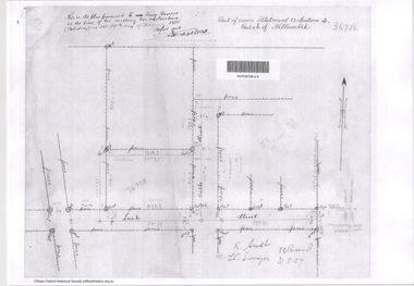
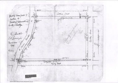
 Eltham District Historical Society Inc
Document - Photocopy, Survey Fleld Notes of Part of Crown Portion 13, Section 4 at Eltham, Parish of Nillumbik, County of Evelyn, 1902-1903
... melbourne Main Road, Henry Street to Diamond Street; Silver Street ...Main Road, Henry Street to Diamond Street; Silver Street to Bible Street Application No. 0337771902, 1903, arthur street, bible street, bird street, diamond creek (creek), diamond street, eltham, eltham railway station, henry street, main road, silver street, survey plan, vine street, application 33777, map -
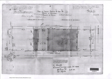
 Eltham District Historical Society Inc
Document - Photocopy, Survey Fleld Notes of Part of Crown Portion 13, Section 4 at Eltham, Parish of Nillumbik, County of Evelyn, 18 May 1908
... melbourne Portion of land bounded by: Main Road, Luck Street, Bible ...Portion of land bounded by: Main Road, Luck Street, Bible Street, Arthur Street Application 37314 W. P. Steane, M.C.E. Civil Engineer and Surveyor, 18 May 1908application 37314, arthur street, bible street, eltham, luck street, main road, map, survey plan -
 Eltham District Historical Society Inc
Document - Photocopy, Survey Fleld Notes of Part of Crown Portion 13, Section 4 at Eltham, Parish of Nillumbik, County of Evelyn, 31 May 1907
... Street Main Road Map Survey Plan A4 printouts, 2 pages Survey ...Portion of land east of Main Road and north of Luck Street bounded by Bible Street Application 36708 K. Arndt, Licensed Surveyor, 31 May 1907application 36708, bible street, eltham, luck street, main road, map, survey plan -
 Eltham District Historical Society Inc
Document - Photocopy, Survey Fleld Notes of Part of Crown Portion 13, Section 4 at Eltham, Parish of Nillumbik, County of Evelyn, November 1909
... Eltham henry street Main Road Map Survey Plan A4 printout Survey ...Portion of land bounded by Main Road, Arthur Street, Bible Street, Henry Street Application 36708 K. Arndt, Licensed Surveyor, November 1909application 5289, arthur street, bible street, eltham, henry street, main road, map, survey plan -
 Eltham District Historical Society Inc
Document - Photocopy, Survey Fleld Notes of Part of Crown Portion 12, Section 4 at Eltham, Parish of Nillumbik, County of Evelyn, 12 October 1910
Portion of land bounded by: Main Road, John Street, Bible Street, Pitt Street Application 38858 K. Arndt, Licensed Surveyor, 12 August 1910application 38858, bible street, eltham, john street, main road, map, pitt street, survey plan -
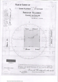 Eltham District Historical Society Inc
Document - Photocopy, Survey Fleld Notes of Part of Crown Portion 12, Section 4 at Eltham, Parish of Nillumbik, County of Evelyn, 20 May 1911
... Street Bridge Street Eltham Main Road Map Survey Plan York Street ...Portion of land bounded by: Main Road, York Street, Bible Street, Bridge Street Application 38629 Frederick Dudley Smith, M.C.E. Licensed Surveyor, 20 May 1911application 38629, bible street, bridge street, eltham, main road, map, survey plan, york street -
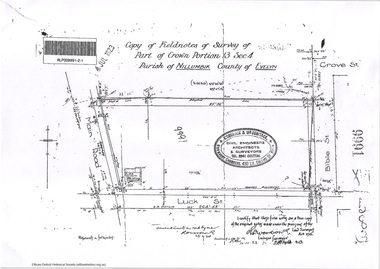 Eltham District Historical Society Inc
Document - Photocopy, Survey Fleld Notes of Part of Crown Portion 13, Section 4 at Eltham, Parish of Nillumbik, County of Evelyn, 7 January 1924
... Road Map Survey Plan A4 printouts, 2 pages Survey Fleld Notes ...Portion of land north of Luck Street bounded by: Main Road, Bible Street Application 9991 R. Woodstock, Land Surveyor, 7 January 1924application 9991, bible street, eltham, luck street, main road, map, survey plan -
 Eltham District Historical Society Inc
Document - Photocopy, Survey Fleld Notes of Part of Crown Portion 13, Section 4 at Eltham, Parish of Nillumbik, County of Evelyn, 7 May 1925
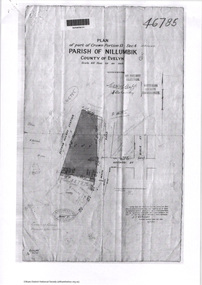
... Station Luck Street Main Road Map Survey Plan A4 printouts, 2 ...Portion of land bounded by: Main Road, Eltham Railway Station Application 46785 J.T. Robinson, Surveyor, 7 May 1925application 46785, arthur street, bible street, eltham, eltham railway station, luck street, main road, map, survey plan -
 Eltham District Historical Society Inc
Document - Photocopy, Survey Fleld Notes of Part of Crown Portion 12, Section 4 at Eltham, Parish of Nillumbik, County of Evelyn, 30 September 1925
... Brougham Street Eltham franklin street Main Road Map Survey Plan A4 ...Portion of land bounded by: Main Road, Franklin Street, Bible Street, Brougham Street Application 46839 R. Woodcock, Licensed Surveyor, 30 September 1925application 46839, bible street, brougham street, eltham, franklin street, main road, map, survey plan -
 Eltham District Historical Society Inc
Survey Fleld Notes of Part of Crown Portion 13, Section 4 at Eltham, Parish of Nillumbik, County of Evelyn, 17 May 1926
... Road, Luck Street, Arthur Street Application 4182/215 J.T ...Portion of land bounded by: Eltham Railway Station, Main Road, Luck Street, Arthur Street Application 4182/215 J.T. Robinson, Licensed Surveyor, 17 May 1926application 4182/215, arthur street, eltham, eltham railway station, luck street, main road, map, survey plan