Showing 372 items matching "roof tiles"
-
 Whitehorse Historical Society Inc.
Photograph, Bundoora Park Homestead
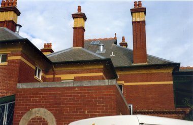
In 1900, Mr J. V. Smith, the owner of Bundoora Park, organised a public competition for a design, in the Queen Ann style, for a mansion to be situated on the property. Australian Tesselated Tile Co. of Mitcham supplied many of the tiles and decorations for the building.Coloured photograph showing the detail on the roof and chimneys at Bundoora Park Homestead, Bundoorabundoora park homestead, australian tesselated tile co. pty ltd, tiles -
 Whitehorse Historical Society Inc.
Photograph, Bundoora Park Homestead
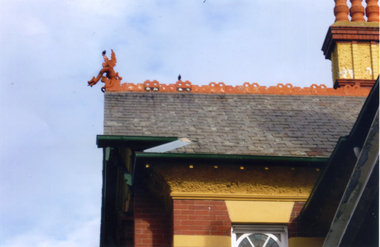
Coloured photograph of a section of the roof at Bundoora Park, Bundoora, showing ornamental detailing and a griffin, which was supplied by the Australian Tesselated Tile Co. of Mitchambundoora park homestead, australian tesselated tile co. pty ltd, tiles -
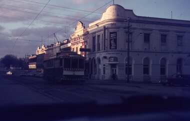
 Ballarat Tramway Museum
Slide - 35mm slide/s, David Verrier, 6/10/1964 12:00:00 AM
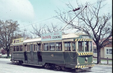
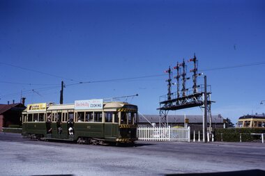
Yields information about the appearance of tram 40 at the Lydiard St terminus and the overhead pan at this location.Agfa colour slide, white blue plastic mount. Photograph by David Verrier of No. 40 at the Lydiard St North terminus. Tram has roof advertisements for Eureka Roofing Tiles and Electricity for Cooking Tram destination set for Sebastopol. Note the pan in the overhead to assist placement of the trolley pole.On back of slide in pencil "Tues 6/10/64 Ballarat, Tram No. 40 at Lydiard St terminus"tramways, trams, lydiard st north, overhead, tram 40 -
 Ballarat Tramway Museum
Slide - 35mm slide/s, Robert Thomson, c1966
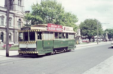
Yields information about Ballarat's trams during c1966 and the City terminus.AGFA blue / white plastic mount, colour slide of No. 33, c1966, in Sturt St at the City or Lydiard St North stop. The Town Hall is in the background. Tram has the destination of Mt Pleasant and has the white on black destination roll. Has roof adverts for Electric Cooking and Eureka Roofing Tiles.tramways, trams, sturt st, town hall, tram 33 -
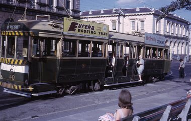
 Ballarat Tramway Museum
Photograph - Black & White Photograph/s, Keith Kings, 3/03/1968 12:00:00 AM
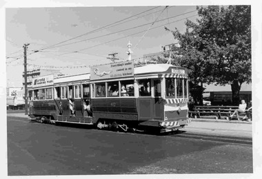
Black and White photograph contained with Reg. Item 1902 - Photo Album from Keith Kings to Les Denmead 1970. Photograph of SEC Ballarat tram 40 at corner of Sturt St and Lydiard St. North, City. Tram showing destination "Victoria St". Has Eureka Roofing Tiles and 'Everything's under control in my electric kitchen" roof advertising boards. Photo taken 3/3/68 Keith Kings No. 28-31 Scanning: i - image file, p - presentation file, b - back of photograph.Stamp in top left hand corner and handwritten number with "K.S. Kings No.28-31 Copyright reserved". Had crossed out number J(u)(12) In blue ink "Ballarat / No. 40 / Sturt St at Lydiard St. North, City / 3/3/68"trams, tramways, ballarat, sturt st, city, tram 40 -
 Ballarat Tramway Museum
Photograph - Black & White Photograph/s - set of 2, Dave Macartney, Feb. 1979
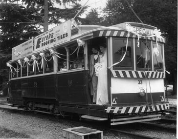
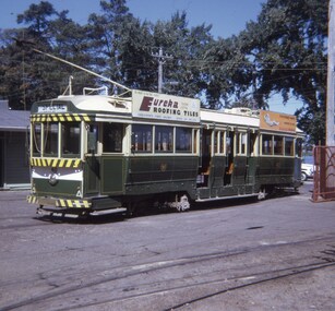
... Roofing Tiles ad on roof. Photo by Dave Macartney - 2/1979... Eureka Roofing Tiles ad on roof. Photo by Dave Macartney - 2 ...Black and white photograph of SEC Tram 33, as the BTM's first wedding tram in Feb. 1979. Photographed on No. 2 road on the depot fan with crossover and 3 road extension in background. Tram has been decorated for the wedding and has the couple standing in the doorway. See also 1978/79 annual report, back cover for another photograph of this occasion. Tram has Eureka Roofing Tiles ad on roof. Photo by Dave Macartney - 2/1979. Photocopy made 4/1999 for display purposes. 1015.1 - similar photo, but with whole of tram in the the photo - added 9/11/2005. see - 1978/1979 Annual Report of the Ballarat Tramway Preservation Society Ltd.trams, tramways, weddings, btm, btm depot, tram 33 -
 Ballarat Tramway Museum
Photograph - B&W print of donated negative, 29/10/1962 12:00:00 AM
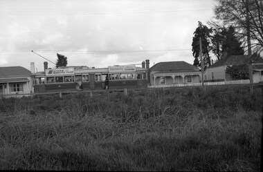
Black and white print of a donated negative. Print made 8/1998. Photo of SEC tram No. 40 in Barkly St., Ballarat, Mt. Pleasant line. Side on view of the tram going up a slight hill, looking across a vacant block of land. Photo taken 29-10-1962. Ron Fluck collection. Has "Eureka Roofing Tiles" and SEC "Electricity Best for Cooking" advertisements on the roof of the tram. High Res scan of negative added 17/1/2019.tramways, trams, mt pleasant, barkly st., ballarat, 40, tram 40 -
 Ballarat Tramway Museum
Photograph - Colour Photograph/s, John Phillips, c1980
... Sturt St. W, with Eureka Tiles advertisement, a SEC roof... Aidans Dve, with the APM Paper roof advertisement) and tram 33 ...Colour photograph of BTPS trams 27 and 33 crossing at the Depot Loop, c1980. Tram 27 southbound (showing St Aidans Dve, with the APM Paper roof advertisement) and tram 33 (showing Gardens via Sturt St. W, with Eureka Tiles advertisement, a SEC roof advertisement and a Twin Lakes sign) northbound through the loop. Tram 33 being driven by Carolyn Dean. Photo by John Phillips Colour photocopy, laminated, of this photograph on display 5/2000 at 02-02-06, but accidently cut off part of tram 27 in the photocopy. 2nd copy added for display purposes 24/10/05.btps, gardens loop, wendouree parade, tram 27, tram 33 -
 Ballarat Tramway Museum
Slide - 35mm slide/s, Travis Jeffrey, late 1960's
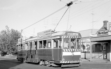
Agfa plastic mount (blue base, white cover) of a photograph of No. 33 southbound in Lydiard St Nth crossing Mair St. Photo taken late 1960's. Has Howard Smith building in the background and other buildings on the east side of Lydiard St. North and the rail level crossing gates. Photo taken from a motor car, just after sunset. Tramcar has Eureka Roofing tiles and Everything's under control in my all electric kitchen roof advertisement. Slide rescanned at 3200 dpi 25-10-2020, jpg replaced, tiff file retained. This file was scanned in 2003 and may show colour changes."BAS 47" in penciltramways, trams, mair st, lydiard st nth, tram 33 -
 Ballarat Tramway Museum
Slide - 35mm slide/s - set of 2, Peter Moses, Jan. 1966
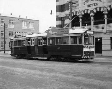
Photo of SEC Ballarat Tram No. 40 at the City terminus in Sturt St. at Lydiard St. Tram has destination of "Mt Pleasant" and roof advertisements for Eureka roofing tiles and SEC "Electricity Best for Cooking". In the background are the Post Office and the ANZ bank buildings. The driver and conductor appear to be looking at the points. 2041.1 - with lady boarding the tram 2041.2 - with conductor returning to the tram. All of the tram in the photo. Note lady on the seat. Kodak cardboard mount slide, taken by Peter Moses January 1966.On back of both slides in blue ink "Jan. 1966 “Main St.” Ballarat No. 40 / 125 f11" and in bottom right hand corner "P. Moses".tramways, trams, city terminus, sturt st, tram 40 -
 Ballarat Tramway Museum
Photograph - Colour Photograph/s, Austin Brehaut, 15/03/2003 12:00:00 AM
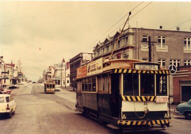
... the Eureka roofing tiles and SEC Briquettes roof advertisements... the Eureka roofing tiles and SEC Briquettes roof advertisements ...Colour photograph of tram 33 terminating at the north end of Gardens Loop, Wendouree Parade, the first service tram to do so on Sat. 15 March 2003. The service was terminated at this point for some 6 weeks while Wendouree Parade was resurfaced and other track work done. Shows the temporary terminal arrangements, and the earth cable installed to protect the work site on the section insulator and earth stake alongside the pole. Tram 33 has the Eureka roofing tiles and SEC Briquettes roof advertisements and Twin Lakes sign on the drivers dash panel. The destination shown is Gardens via Sturt St. West. Photo taken by Austin Brehaut and printed on Kodak paper.In black ink on the rear of the photo "1st car to use short-working during track and road repairs 15.3.03 / APB"btm, road works, gardens loop, wendouree parade, tram 33 -
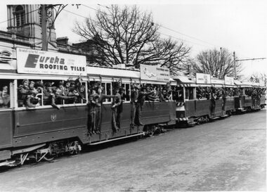 Ballarat Tramway Museum
Photograph - Black & White Photograph/s, The Courier Ballarat, 18/08/1971 12:00:00 AM
... is No. 40, with a Eureka Roofing Tiles and SEC roof advertisement..., lower Sturt St. Lead tram is No. 40, with a Eureka Roofing Tiles ...Yields information about special trams that were operated on the system prior to its closure for the benefit of school children.Black and White copy photograph of a newspaper photograph taken by The Courier - photo taken 18/8/1971, published 19/8/1971 of three bogie cars carrying schoolchildren (Ballarat North Technical College) on tour, lower Sturt St. Lead tram is No. 40, with a Eureka Roofing Tiles and SEC roof advertisement. All the school children have moved to one side for the photograph. See Reg Items 1073 and 2186 for the actual newspaper cuttings. Collected by Alan Bradley from the Ballarat Courier early 1980's. See Excel file "Record of Ballarat Courier Photos SEC era" (Archive Documents) for source of details.tramways, trams, sturt st, tours, special trams, tram 40 -
 Ballarat Tramway Museum
Slide - 35mm slide/s, Eldon Hogan, early 1960's
35mm Kodachrome cardboard mount slide of Ballarat No. 40 southbound in Lydiard St North, crossing the railway level crossing. In the background is Kennedy Murray General Carters building, the main signal gantry and a Walker Rail car - 280HP?. No. 40 has roof advertisements for Eureka Roofing Tiles and "Electricity Best for Cooking". Photo taken early 1960's. Photo from the Eldon Hogan collection. See email with worksheet from R.Gilbert date 29/12/2000 and Fares Please!, May 1995. In ink on the top of the slide "Bogie car at Ballarat Station"tramways, trams, railway station, lydiard st north, signals, tram 40 -
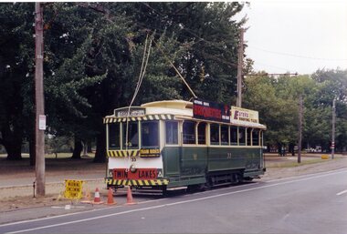
 Ballarat Tramway Museum
Slide - 35mm slide/s, Travis Jeffrey, c1992
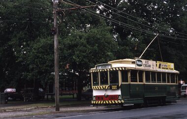
Plastic mount (black base, white cover) of No. 33 northbound in Wendouree Parade near Depot Junction. Tram has Twin Lake sign, roof advertisements for Peters Ice cream and Eureka Roofing Tiles. Photo by Travis Jeffrey, c1992.tramways, trams, wendouree parade, btm, tram 33 -
 Ballarat Tramway Museum
Photograph - Black & White Photograph/s, John Phillips, 1970's
Yields information about the closing days of Ballarat trams, their form and the number of passengers carried probably on a weekend.Black and White photograph of Ballarat No. 40 inbound along Lydiard St North, with the Provincial Hotel in the background. Tram has the destination of Sebastopol and has a Eureka Roofing Tiles and SEC "Everything's under control in my all electric kitchen" roof advertisements. Taken by John Phillips.tramways, trams, lydiard st north, secv, tram 40 -
 Ballarat Tramway Museum
Postcard, Ron Scholten, SEC Ballarat of No. 33
Colour photograph, printed on a postcard back format of SEC Ballarat of No. 33 about to enter the double track section of Lydiard St Nth with another single trucker waiting. No. 33 has the destination of Sebastopol, a front auxiliary board advertising at Fete, Eureka Roofing tiles and a SEC 'Everything is under control in my all electric kitchen' roof advertisement. In the back ground is the Union Fidelity Trustee Co. building and the Mercedes dealership.trams, tramways, lydiard st nth, tram 11, tram 26 -
 Ballarat Tramway Museum
Photograph - Digital image, c1971
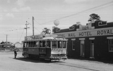
Yields information about Ballarat streetscape and its trams in the closing days of the SEC tramway system.Digital image from a black and white print of tram 33 being reversed at Sebastopol, the driver is reversing the pole. The tram has a Eureka Roofing Tiles and "Bliss Bombs" (Make Bliss not Love) roof advertisement and a "Trotting at Brae Raceway" auxiliary board. In the background is the Sebastopol Royal Mail Hotel, Albert St. Photo by Marc Dahlstrom c1971.On rear is the Marc Dahlstrom stamp.trams, tramways, albert st, sebastopol, tram 33 -
 Ballarat Tramway Museum
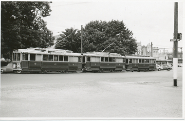
Photograph - Black & White Photograph/s, Lloyd Rogers, 13/12/1961 12:00:00 AM
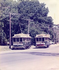
Yields information about the appearance of trams parked in the City loop during early 1960's and the construction of the Big W store.Black and white photograph of Ballarat trams 21, 33 and 26 in the City Loop. Dated 13/12/1961. Printed on Agfa Gevaert paper in a postcard format. 21 - has a roof advertisement fort A. H. Collins of Sebastopol for Timber and The Age and another on the dash panel. 32 - has roof adverts for Penfold Cream Sherry cream and Eureka Terra Cotta tiles. In the background, a building (possibly the future Big W) is under construction in Grenville St. Photo by Lloyd Rogers.In ink "Ballarat trams Nos. 21, 33, 26, Sturt St 13/12/1961 and 3/19". In pencil: "21 - ex 10 Alaide, 33- ex M 189, 26 - ex M 111"trams, tramways, city loop, sturt st, tram 21, tram 33, tram 26 -
 Ballarat Tramway Museum
Slide - 27 mm sq slide/s, Andrew Howlett, No. 40 parked on the depot fan at the SEC Depot, Mar.1968
Yields information about tram 40 in the depot fan during 1968Colour slides, Kodak white cardboard mount, developed March 1968 of No. 40 parked on the depot fan at the SEC Depot. Tram showing Special and has a Eureka Roofing tiles and SEC electric cooking roof advert.ballarat, tramways, trams, depot, sec, tram 40 -
 Ballarat Tramway Museum
Photograph - Ballarat Tram 40 at Mt Pleasant terminus, Robert Wilson, 1-12-1970
Image of Ballarat tram 40 at the Mt Pleasant terminus 1-12-1970. The tram has roof adverts for Eureka Roofing Tiles and Electric Cooking. The metal device above the trolley pole, assisted crews to put the pole back on the overhead, especially at night. The mixed business on the right-hand side has an advert for The Sun newspaper.Yields information about the Mt Pleasant terminus in late 1970.Digital image of Ballarat Tram 40 at Mt Pleasant terminus 1-12-1970trams, tramways, mt pleasant, ballarat tramways, tram 40, trolley poles -
 Kew Historical Society Inc
Photograph - 29 Uvadale Grove, Kew, 1920
The numerous subdivision plans in the Kew Historical Society's collection represent working documents, ranging from the initial sketches made in planning a subdivision to printed plans on which auctioneers or agents listed the prices for which individual lots were sold. In a number of cases, the reverse of a subdivision plan in the collection includes a photograph of a house that was also for sale by the agent. Subdivision plans are historically important documents used as evidence of the growth of suburbs in Australia. They frequently provide information about when the land was sold on which a built structure was subsequently constructed as well as evidence relating to surveyors and real estate and financial agents. These photographs provide significant heritage information relating house design and decoration, fencing and household gardens.When 29 Uvadale Grove, Kew was offered for sale it was described as: ‘Kew. Fine locality, 3 minutes Cotham Road. Splendidly built 6 roomed Brick Villa. Rooms 17 x 14, 16 x 13, &c. Beautifully fitted throughout. Land 70 x 134 to ROW.’ The price was advertised as being £1,400. The house exhibits key features of Federation architecture such as the gabled roof with a facing of half-timber and stucco. The veranda has a curved corrugated iron roof supported by timber pillars and fretwork. The slate roof with terra cotta ridging and finials marks a transition to the more common use of Marseilles tiles in Federation architecture.subdivisions - kew (vic.), 29 uvadale grove - kew (vic.) -
 Kew Historical Society Inc
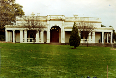
Photograph, Façade of ‘Southesk', Cotham Road, 1970
Colour enlargement of a photograph (slide) of Southesk (formerly Ordsall) in Cotham Road, Kew (demolished 1970).Colour photograph of the front lawn and façade of ‘Southesk’ (formerly ‘Ordsall’, built for John Halfey in 1882). The house was located on the corner of Cotham Road and Charles Street, Kew. The Italianate mansion was built in the Renaissance villa style on a bluestone plinth. Two balustrades surrounded the parapet of the roof and ran between the groups of pillars on either side of the entrance porch. The verandah was tiled and wide and Corinthian columns supported its roof. When the house passed into the hands of the City of Kew in 1948, the landscaping and formal flower beds were removed and replaced by lawns.The house was demolished in 1970.david carnegie, john halfey, southesk - cotham road - kew (vic), ordsall - cotham road - kew (vic) -
 Kew Historical Society Inc
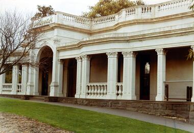
Photograph, Façade of ‘Southesk', Cotham Road, 1970
Colour enlargement of a photograph (slide) of Southesk (formerly Ordsall) in Cotham Road, Kew (demolished 1970).A colour photograph of the façade of ‘Southesk’ taken at an oblique angle. Formerly known as ‘Ordsall’, the house was built for John Halfey in 1882 on the corner of Cotham Road and Charles Street. The Italianate mansion was built in the Renaissance villa style on a bluestone plinth. Two balustrades surrounded the parapet of the roof and ran between the groups of pillars on either side of the entrance porch. The verandah was tiled and wide and Corinthian columns supported its roof. When the house passed into the hands of the City of Kew in 1948, the Council used it for a kindergarten, an elderly citizen centre and as a home for the Leo Baeck Centre. The house was demolished in 1970.david carnegie, john halfey, southesk - cotham road - kew (vic), ordsall - cotham road - kew (vic) -
 Kew Historical Society Inc
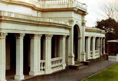
Photograph - Façade of ‘Southesk', Cotham Road, Stewart West, 1970
Colour enlargement of a photograph (slide) of Southesk (formerly Ordsall) in Cotham Road, Kew (demolished 1970).A colour photograph of the façade of ‘Southesk’ taken at an oblique angle. Formerly known as ‘Ordsall’, the house was built for John Halfey in 1882 on the corner of Cotham Road and Charles Street. The Italianate mansion was built in the Renaissance villa style on a bluestone plinth. Two balustrades surrounded the parapet of the roof and ran between the groups of pillars on either side of the entrance porch. The verandah was tiled and wide and Corinthian columns supported its roof. When the house passed into the hands of the City of Kew in 1948, the Council used it for a kindergarten, an elderly citizen centre and as a home for the Leo Baeck Centre. The house was demolished in 1970.david carnegie, john halfey, southesk - cotham road - kew (vic), ordsall - cotham road - kew (vic) -
 Kew Historical Society Inc
Photograph - 'Fernhurst', 13 Fernhurst Grove, 1978
George Wharton arrived in Melbourne in 1844. An architect and surveyor, he was appointed to lay out the 'Village of Kew' by N.A. Fenwick following the land sales of 1851. A protagonist for Kew's separation from the Boroondara District Road Board, he was elected chairman when Kew achieved municipal status in December 1860. His home, 'Fernhurst', was built in 1866 on eight acres in Studley Park, with a four-storey tower and pyramidal roof. The Italianate home was a prominent Kew landmark. It was demolished in 1979 and replaced by St Paul's College in 1980.Rare colour photograph of what was once a significant mansion in Kew.Original colour positive photograph (Kodak print) of 'Fernhurst' in 1978. Photographed by Stewart West in May 1978, one year before it was demolished, the photograph gives little idea of the large landholding once surrounding the house. Originally accessed from near the corner of Princess Street and Studley Park Road, its gardens had been subdivided in the 1900s and its footprint restricted to 13 Fernhurst Grove. Like many other grand houses, by the 1970s it had been converted into apartments. From the photograph, one can see that the house had retained many of its original features such as the distinctive tower and the wide bow-fronted verandah. The slates on the roof (apart from those on the tower) had been replaced by tiles and the cement render of the exterior painted white. Annotated reverse: "View of Fernhurst Home Taken from Street / 10"fernhurst, 13 fernhurst grove -- kew (vic.), george wharton, italianate architecture, vila maria society, st paul's school for the blind -
 Kew Historical Society Inc
Photograph - 'Fernhurst', 13 Fernhurst Grove, 1978
George Wharton arrived in Melbourne in 1844. An architect and surveyor, he was appointed to lay out the 'Village of Kew' by N.A. Fenwick following the land sales of 1851. A protagonist for Kew's separation from the Boroondara District Road Board, he was elected chairman when Kew achieved municipal status in December 1860. His home, 'Fernhurst', was built in 1866 on eight acres in Studley Park, with a four-storey tower and pyramidal roof. The Italianate home was a prominent Kew landmark. It was demolished in 1979 and replaced by St Paul's College in 1980.Rare colour photograph of what was once a significant mansion in Kew.Original colour positive photograph (Kodak print) of 'Fernhurst' in 1978. Photographed by Stewart West in May 1978, one year before it was demolished, the photograph gives little idea of the large landholding once surrounding the house. Originally accessed from near the corner of Princess Street and Studley Park Road, its gardens had been subdivided in the 1900s and its footprint restricted to 13 Fernhurst Grove. Like many other grand houses, by the 1970s it had been converted into apartments. From the photograph, one can see that the house had retained many of its original features such as the distinctive tower and the wide bow-fronted verandah. The slates on the roof (apart from those on the tower) had been replaced by tiles and the cement render of the exterior painted white. Annotated reverse: "Fernhurst from higher ground level side shot / 7"fernhurst, 13 fernhurst grove -- kew (vic.), george wharton, italianate architecture, vila maria society, st paul's school for the blind -
 Kew Historical Society Inc
Photograph - 'Fernhurst', 13 Fernhurst Grove, 1978
George Wharton arrived in Melbourne in 1844. An architect and surveyor, he was appointed to lay out the 'Village of Kew' by N.A. Fenwick following the land sales of 1851. A protagonist for Kew's separation from the Boroondara District Road Board, he was elected chairman when Kew achieved municipal status in December 1860. His home, 'Fernhurst', was built in 1866 on eight acres in Studley Park, with a four-storey tower and pyramidal roof. The Italianate home was a prominent Kew landmark. It was demolished in 1979 and replaced by St Paul's College in 1980.Rare colour photograph of what was once a significant mansion in Kew.Original colour positive photograph (Kodak print) of 'Fernhurst' in 1978. Photographed by Stewart West in May 1978, one year before it was demolished, the photograph gives little idea of the large landholding once surrounding the house. Originally accessed from near the corner of Princess Street and Studley Park Road, its gardens had been subdivided in the 1900s and its footprint restricted to 13 Fernhurst Grove. Like many other grand houses, by the 1970s it had been converted into apartments. From the photograph, one can see that the house had retained many of its original features such as the distinctive tower and the wide bow-fronted verandah. The slates on the roof (apart from those on the tower) had been replaced by tiles and the cement render of the exterior painted white. Annotated reverse: "Back view of Fernhurst / 8"fernhurst, 13 fernhurst grove -- kew (vic.), george wharton, italianate architecture, vila maria society, st paul's school for the blind -
 Kew Historical Society Inc
Photograph - 'Fernhurst', 13 Fernhurst Grove, 1978
George Wharton arrived in Melbourne in 1844. An architect and surveyor, he was appointed to lay out the 'Village of Kew' by N.A. Fenwick following the land sales of 1851. A protagonist for Kew's separation from the Boroondara District Road Board, he was elected chairman when Kew achieved municipal status in December 1860. His home, 'Fernhurst', was built in 1866 on eight acres in Studley Park, with a four-storey tower and pyramidal roof. The Italianate home was a prominent Kew landmark. It was demolished in 1979 and replaced by St Paul's College in 1980.Rare colour photograph of what was once a significant mansion in Kew.Original colour positive photograph (Kodak print) of 'Fernhurst' in 1978. Photographed by Stewart West in May 1978, one year before it was demolished, the photograph gives little idea of the large landholding once surrounding the house. Originally accessed from near the corner of Princess Street and Studley Park Road, its gardens had been subdivided in the 1900s and its footprint restricted to 13 Fernhurst Grove. Like many other grand houses, by the 1970s it had been converted into apartments. From the photograph, one can see that the house had retained many of its original features such as the distinctive tower and the wide bow-fronted verandah. The slates on the roof (apart from those on the tower) had been replaced by tiles and the cement render of the exterior painted white. Annotated reverse: "Fernhurst front view taken from across Fernhurst Grove / 6"fernhurst, 13 fernhurst grove -- kew (vic.), george wharton, italianate architecture, vila maria society, st paul's school for the blind -
 Kew Historical Society Inc
Photograph - 'Fernhurst', 13 Fernhurst Grove, 1978
George Wharton arrived in Melbourne in 1844. An architect and surveyor, he was appointed to lay out the 'Village of Kew' by N.A. Fenwick following the land sales of 1851. A protagonist for Kew's separation from the Boroondara District Road Board, he was elected chairman when Kew achieved municipal status in December 1860. His home, 'Fernhurst', was built in 1866 on eight acres in Studley Park, with a four-storey tower and pyramidal roof. The Italianate home was a prominent Kew landmark. It was demolished in 1979 and replaced by St Paul's College in 1980.Rare colour photograph of what was once a significant mansion in Kew.Original colour positive photograph (Kodak print) of 'Fernhurst' in 1978. Photographed by Stewart West in May 1978, one year before it was demolished, the photograph gives little idea of the large landholding once surrounding the house. Originally accessed from near the corner of Princess Street and Studley Park Road, its gardens had been subdivided in the 1900s and its footprint restricted to 13 Fernhurst Grove. Like many other grand houses, by the 1970s it had been converted into apartments. From the photograph, one can see that the house had retained many of its original features such as the distinctive tower and the wide bow-fronted verandah. The slates on the roof (apart from those on the tower) had been replaced by tiles and the cement render of the exterior painted white. Annotated reverse: "Front view of Fernhurst showing tower to advantage / 9"fernhurst, 13 fernhurst grove -- kew (vic.), george wharton, italianate architecture, vila maria society, st paul's school for the blind -
 Kew Historical Society Inc
Photograph - 'Fernhurst', 13 Fernhurst Grove, 1978
George Wharton arrived in Melbourne in 1844. An architect and surveyor, he was appointed to lay out the 'Village of Kew' by N.A. Fenwick following the land sales of 1851. A protagonist for Kew's separation from the Boroondara District Road Board, he was elected chairman when Kew achieved municipal status in December 1860. His home, 'Fernhurst', was built in 1866 on eight acres in Studley Park, with a four-storey tower and pyramidal roof. The Italianate home was a prominent Kew landmark. It was demolished in 1979 and replaced by St Paul's College in 1980.Rare colour photograph of what was once a significant mansion in Kew.Original colour positive photograph (Kodak print) of 'Fernhurst' in 1978. Photographed by Stewart West in May 1978, one year before it was demolished, the photograph gives little idea of the large landholding once surrounding the house. Originally accessed from near the corner of Princess Street and Studley Park Road, its gardens had been subdivided in the 1900s and its footprint restricted to 13 Fernhurst Grove. Like many other grand houses, by the 1970s it had been converted into apartments. From the photograph, one can see that the house had retained many of its original features such as the distinctive tower and the wide bow-fronted verandah. The slates on the roof (apart from those on the tower) had been replaced by tiles and the cement render of the exterior painted white. Annotated reverse: "Fernhurst corner shot through trees / 12-22"fernhurst, 13 fernhurst grove -- kew (vic.), george wharton, italianate architecture, vila maria society, st paul's school for the blind