Showing 17619 items matching "runners-up"
-
 Lakes Entrance Historical Society
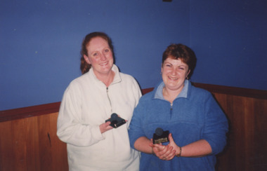
Photograph - Squash, Lakes Post Newspaper, 1/09/2001 12:00:00 AM
Colour photograph of squash team the Bangers and Mash, Debbie Radcliffe Smith and Natasha Sztynde runners up Lakes Entrance Victoriasports, squash -
 National Vietnam Veterans Museum (NVVM)
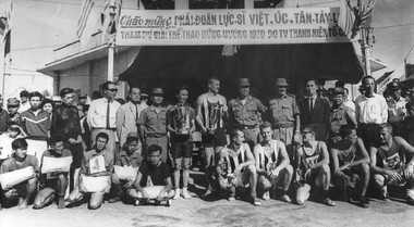
Photograph, Gibbons, Denis, Great Hung Vuong Day Road Race
Denis Gibbons (1937 – 2011) Trained with the Australian Army, before travelling to Vietnam in January 1966, Denis stayed with the 1st Australian Task Force in Nui Dat working as a photographer. For almost five years Gibbons toured with nine Australian infantry battalions, posting compelling war images from within many combat zones before being flown out in late November 1970 after sustaining injuries. The images held within the National Vietnam Veterans Museum make up the Gibbons Collection. A black and white photograph of a Group photo of the placed runners in the 5000 metre footrace from the market place at Long Dien. The race was run on the Vietnamese National DayTHE GREAT HUNG VUONG DAY ROAD RACE - 15th APRIL 1970: Hung Vuong Day, 15th April 1970, the Vietnamese National Day commemorating the events of the birth of the Vietnamese Race, is on of the most important festivals of the Vietnamese Memorabilia. The placed contestant athletics in the 5000 metre foot race from the market place at Long Dien, south east of Nui Dat, the 1st Australian Task force Base, along national Route 23 to the town square at Baria (Phuoc Le), the Phuoc Tuy Province Capital. The multi coloured shirts of the various contestants, from the numerous military and civilian units in the province and the Australian Task Force looked out of place in the war zone. It took 17 minutes, 5 seconds for the outright winner to get to the finish, a strapping young SAS soldier, Trooper John Thurgar, from Scone, N.S.W. of the 1st Special Air Service Squadron, one of the Australian contestants. The first prize, silver cup, was presented to Trooper Thrugar by Colonel Tu, The Province Chief, Colonel Peter Falkland, the 1st Australian Task Force Deputy Commander presented the first Vietnamese contestant across the finish line with a silver cup. In all there were trophies for the first siz places by the Vietnamese and the "visitors", SAS took the first three Australian/New Zealand places whilst the last three came from other 1st Australian Task Force Units, the first prize for each of the individual winners was a large silver cup, for the next five runners up, by the Australians there was a smaller silver cup, for the Vietnamese first place there was a silver cup the same size as for the Australian, outright, winner, while the next five Vietnamese runners up received a parcel of clothing and towels.photograph, 1st sas sqn, baria, phuoc tuy province, vietnamese national day, gibbons collection catalogue, great hung vuong day road race, trooper john thurgar, national route 23, nui dat, long dien village, col tu, col peter falkland, 1st special air squandron, the province chief, 1st australian task force, 3390, royal regiment of australian artillery, denis gibbons -
 Ringwood and District Historical Society
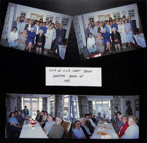
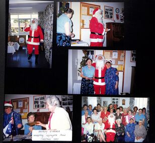
Photograph, Ringwood CWA Craft Group Christmas Break-up in 1996
Kindly scanned from Ringwood Branch archival collection -
 Ringwood and District Historical Society
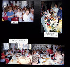
Photograph, Ringwood CWA Branch meeting and Christmas break-up in 1997
Kindly scanned from Ringwood Branch archival collection -
 Ringwood and District Historical Society
Photograph, Ringwood CWA Branch Christmas break-up in 1997
Kindly scanned from Ringwood Branch archival collection -
 Ringwood and District Historical Society
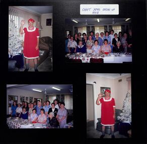
Certificate, Ringwood CWA craft Christmas break-up in 1998
Kindly scanned from Ringwood Branch archival collection -
 Ringwood and District Historical Society
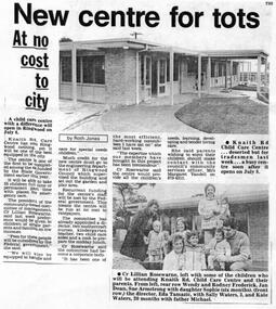
Newspaper, Knaith Road Child Care Centre, Ringwood East, start-up of centre on 8 July 1985
Ringwood Mail 26 June 1985 -
 Ringwood and District Historical Society
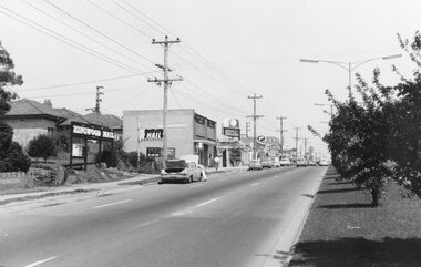
Photograph, Maroondah Highway East, Ringwood- 1969. Looking west towards Ringwood up from Ringwood Lake
Black and white photographImage shows Ringwood Mail Office on south side of Highway. -
 Ringwood and District Historical Society
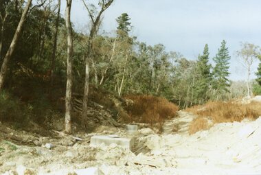
Photograph, View up the gully from Glenvale Road, North Ringwood towards the spot of the wall of Loughnan's Lake was
The brown undergrowth is on the remains of the walls, since levelled. Circa 1979. Part of a 51-photo record of the development of the "Kubis" Estate, Ringwood North, including road works to Debbie Place, Kubis Drive, Werac Drive, Manuelo Drive, Iluka Place and Glenvale Road. From the Jack Lundy Clarke collection. -
 Ringwood and District Historical Society
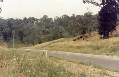
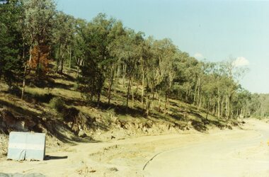
Photograph, Looking south up Werac Drive, North Ringwood past Manuelo Drive in February 1979
E552 N21 Part of a 51-photo record of the development of the "Kubis" Estate, Ringwood North, including road works to Debbie Place, Kubis Drive, Werac Drive, Manuelo Drive, Iluka Place and Glenvale Road. From the Jack Lundy Clarke collection. -
 Ringwood and District Historical Society
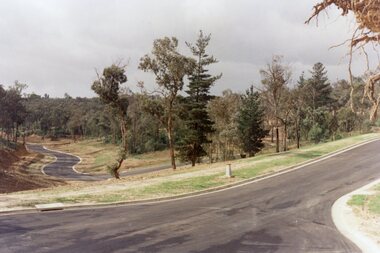
Photograph, Kubis Estate, North Ringwood in April 1978. View east up Kubis Drive from Jenkin Close past the foot of Werac Drive
E549 N16 Part of a 51-photo record of the development of the "Kubis" Estate, Ringwood North, including road works to Debbie Place, Kubis Drive, Werac Drive, Manuelo Drive, Iluka Place and Glenvale Road. From the Jack Lundy Clarke collection. -
 Ringwood and District Historical Society
Photograph, Kubis Estate, North Ringwood in April 1978. View east up Kubis Drive over Jenkin Close and intersection with Werac Drive
E549 N18 Part of a 51-photo record of the development of the "Kubis" Estate, Ringwood North, including road works to Debbie Place, Kubis Drive, Werac Drive, Manuelo Drive, Iluka Place and Glenvale Road. From the Jack Lundy Clarke collection. -
 Ringwood and District Historical Society
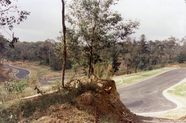
Photograph, Kubis Estate, North Ringwood in April 1978. Looking up the hill in Kubis Drive from the site of headwaters of Loughnan's Lake. Jenkins Close takes off to the right from centre
E548 N31 Part of a 51-photo record of the development of the "Kubis" Estate, Ringwood North, including road works to Debbie Place, Kubis Drive, Werac Drive, Manuelo Drive, Iluka Place and Glenvale Road. From the Jack Lundy Clarke collection. -
 Ringwood and District Historical Society
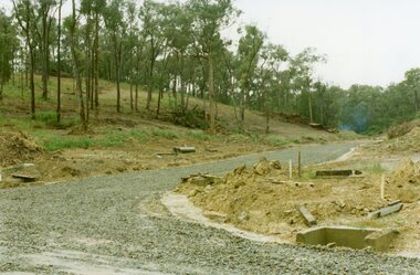
Photograph, Looking east up the gully over the intersection of Werac and Kubis Drives, North Ringwood, in February 1978
E546 N3 Part of a 51-photo record of the development of the "Kubis" Estate, Ringwood North, including road works to Debbie Place, Kubis Drive, Werac Drive, Manuelo Drive, Iluka Place and Glenvale Road. From the Jack Lundy Clarke collection. -
 Ringwood and District Historical Society
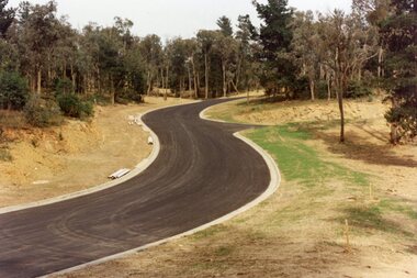
Photograph, Looking up Debbie Place, North Ringwood, on 3rd November 1978, that has box sheet of metal
E551 N14 Part of a 51-photo record of the development of the "Kubis" Estate, Ringwood North, including road works to Debbie Place, Kubis Drive, Werac Drive, Manuelo Drive, Iluka Place and Glenvale Road. From the Jack Lundy Clarke collection.51 -
 Ringwood and District Historical Society
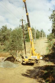
Photograph, SEC poles going up in Glenvale Road, North Ringwood, on 14 May April 1998
E548 N37, N39 & N41 Part of a 51-photo record of the development of the "Kubis" Estate, Ringwood North, including road works to Debbie Place, Kubis Drive, Werac Drive, Manuelo Drive, Iluka Place and Glenvale Road. From the Jack Lundy Clarke collection.51 -
 Ringwood and District Historical Society
Photograph, Eastern views from 6-10 Ringwood Street, Ringwood up to former Civic Place in 2008
Photographic record by Russ Haines, RDHS, in 2008. -
 Ringwood and District Historical Society
Photograph, Former Commonwealth Bank on Melbourne Street, Ringwood in 2008. Includes other businesses and opens up to Maroondah Highway
Photographic record by Russ Haines, RDHS, in 2008. -
 Ringwood and District Historical Society
Photograph, East side of Melbourne Street, Ringwood in 2008, opens up to Maroondah Highway with Railway Station over the road
Photographic record by Russ Haines, RDHS, in 2008. -
 Ringwood and District Historical Society
Documents, Handwritten Burns Family history including Ringwood connections of children of George Paul Burns and Mary Jane Burns up to 1999, unknown
Biography of the Burns family including Clarence Henry Burns, who with his wife Rose lived in Warrandyte Road. He was a great sportsman, part-time fireman, worked for the Ringwood Council among other things winding the clock on the clocktower. Also a member of the Ringwood Garden Club.4 foolscap hand written pages documenting the Burns family.(Written by Lillian Burns) -
 Ringwood and District Historical Society
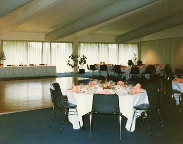
Photograph, Coloured photo of the Karralyka theatre convention centre set up with round tables ready for a reception
Convention Centre -
 Ringwood and District Historical Society
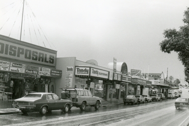
Photograph, Maroondah Highway, Ringwood on 12 September 1988, showing Ringwood Disposals, Tandy Electronics, TAB and other shops going up to Ringwood Street
Digital photograph -
 Kiewa Valley Historical Society
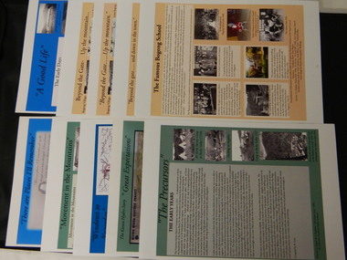
Posters - 10 in the Set, The Famous Bogong School; Beyond the Gate - (up and down); A Good Life; The Precursors; Great Expectations; Windows to Yesterday; Movement in the Mountains; Life wasn't meant to be Easy; There are Places I'll Remember, 1998
These posters were produced or a display during the Mt Beauty Music Festival in 1998. They cover the history of the Kiewa Valley from the early days, farming and the Kiewa Hydro Electric Scheme.These posters summarise the history of the Kiewa Valley and were compiled using publications, memories and documents. The posters are clear and useful for displaySee KVHS 0164 A4 glossy cardboard posters: Beige, Blue or Green with photos and writing of the history of different aspects of the Kiewa Valley. 1. Bogong 2. Mt Beauty 3. Bogong 4. The Early Days 5. The Early Years 6. The Kiewa Hydro Story 7. The Kiewa Valley Runs 8. Roads constructed 9. The 1930's 10. Pre 1930bogong state school; bogong village; secv; khes; tawonga; surveyors; mt beauty; camps; kiewa valley -
 Christ Church Anglican Parish of Warrnambool
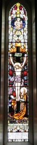
Memorial Window: John Edward BENNETT, Crucifixion "I, if I be lifted up from the earth/ will draw all men unto me"
John Edward Bennett was born in Leeds, Yorkshire, 1862. He was devoted to his family and his church, being a churchwarden and a verstryman of this Parish. He was a lay preacher for 40 years in the Dioceses of Melbourne and Ballarat. He was the first Manager of the Warrnambool Woollen Mill. He died on Nov 10th 1928.He was the first manager of Warrnambool Woollen Mill.Stained glass memorial lancet window, central light, west wall, north nave, depicting the crucifixion of Jesus.To the Glory of God and in loving memory of/John Edward Bennett/ sometime Churchwarden and Vestryman of this Parish, and for/40 years a Lay Reader in the Dioceses of Melbourne and/ Ballarat, born in Leeds, Yorkshire, 1862, entered into rest Nov 10th, 1928/ A devoted husband and father,/ a faithful servant of God and His Church/Not slothful in business, fervent in spirit, serving the Lord.memorial stained glass window lancet window bennett je bennett john edward bennett warrnambool woollen mill -
 Eltham District Historical Society Inc
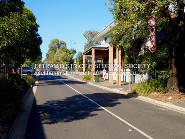
Photograph - Digital Photograph, Jim Connor, View looking up Pryor Street from Main Road, Eltham, 18 April 2018
jim connor collection, commercial place, eltham shopping centre, pryor street -
 Eltham District Historical Society Inc
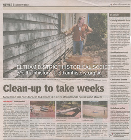
Newsclipping, Shaun Campbell, Clean-up to take weeks, Diamond Valley Leader, December 2011
A late afternoon storm on Christmas Day 2011. A flash flood occurred from significant rain fall and hail, which accumulated along an old waterway with floodwater submerging cars along Valonia Drive then down Grove Street flooding houses, through the Bible Street Reserve where it then submerged Main Road washing away the small railway trestle bridge opposite the reserve then flooding the Judge Book Village before finally entering the Diamond Creek. Widespread damage occured from hail and flash flooding.fay bridge collection, eltham, flood damage, floods, floodwater -
 Eltham District Historical Society Inc
Newspaper - Newspaper Clipping, Sean Selleck, Tennis club serves up slice of history, Diamond Valley Leader, 17 July, p4, 2019
50th anniversary celebrations of Eltham Tennis Club50th anniversary, eltham tennis club, heidelberg golf club, ian mcmaster, john dinsmore, laurie sparks, terry bain -
 Eltham District Historical Society Inc
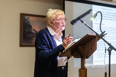
Photograph, Peter Pidgeon, Catherine Kingsbury who originally set up Food Share which continues to run out of the Maternal and Infant Welfare Centre; Eltham Community Town Hall Meeting, Eltham Senior Citizen's Centre, 13 October 2018, 13 Oct 2018
Community meeting held at the Eltham Senior Citizen's Centre to discuss Nillumbik Shire Council's advertised proposal to sell the former Shire Office site at 895 Main Road and the Eltham War Memorial complex of buildings at 903-907 Main Road; 13 October 2018Born digital image895 main road, 903-907 main road, community meeting, eltham pre-school, eltham shire office, eltham war memorial, eltham war memorial hall, infant welfare centre, nillumbik shire council, senior citizen's centre -
 Eltham District Historical Society Inc
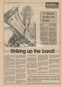
Newsclipping, Striking up the band by Carolyn Rance, Diamond Valley News, 12 March 1985, p4, 12 Mar 1985
Digital file only - Digitised by EDHS from a scrapbook on loan from Beryl Bradbury (nee Stokes), daughter of Frank Stokes.alf mundy, beryl bradbury (nee stokes) collection, eltham brass band, molly mundy -
 Eltham District Historical Society Inc
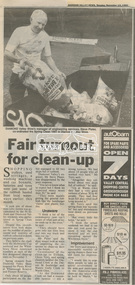
Newspaper clipping, Fair turnout for clean-up, Diamond Valley News, 12 November 1991, 1991
Spring Clean 1991, Shire of Diamond ValleyNewsprint1991, eltham festival, shire of diamond valley, steve plater