Showing 8444 items
matching snowy-river-dry-cleaners
-
 Port Fairy Historical Society Museum and Archives
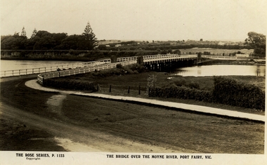
Postcard, The Rose Series / The Rose Stereographs, The Bridge over Moyne River, Port Fairy Vic
Black and white Photograph of the Moyne river road bridge with the botanical gardens in the left background and some huts built possibly on Hughes AvenueThe Rose Series P.1123 copyright.- The Bridge over the Moyne River Port Fairy Vic.moyne bridge, hughes avenue, gipps street, river, dunes, botanical gardens -
 Port Fairy Historical Society Museum and Archives
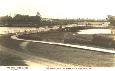
Postcard, The Rose Series / The Rose Stereographs, The Bridge over Moyne River, Port Fairy Vic
Black and white Photograph of the bridge over the Moyne river with the Botanical Gardens on the left in the background and also some huts on Hughes Avenue in the backgroundThe Rose Series P. 1123 copyright- The Bridge over the Moyne River Port Fairy Vic.moyne bridge circa 1930, moyne river, bridge, river, botanical gardens -
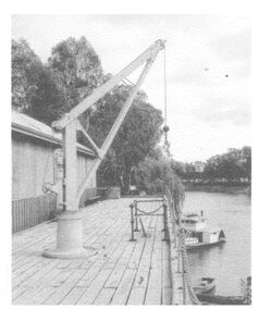
 Port Melbourne Historical & Preservation Society
Photograph, Paddle Steamer Weeroona in Dule's and Orr's Dry Dock, 1900s
Copyright Queenscliff Historical museum. Paddle Steamer Weeroona in Duke's and Orr's Dry Dock. Black and white photo . Shows vessel resting on keel blocks. Two men in foreground standing on dock floor. Shows wooden dock walls and pump house on right.transport - shipping, maritime, ps weeroona, duke's and orr's dry dock -
 Wodonga & District Historical Society Inc
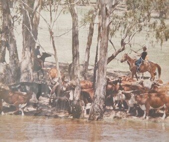
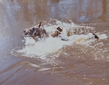
Album - Ringer's River by Des Martin - Plate 21 - Swimming cattle across to Victoria
But O'Day, the general, has chosen this particular time to ride up river and meet a mob of cattle that Charlie Clowes is bringing down for him from Camoola. In the first of many such successful operations the cattle are swum across to Victoria at the point where O'Day's run, Brightons, comes down to the river.The album and images are significant because they document literature written by a prominent member of the Wodonga community. The presentation of this precis was supported by several significant district families and individuals.Ringer's River Album Coloured photo Plate 21des martin, many a mile, ringer's river, northeast victoria stories -
 Greensborough Historical Society
Photograph, Plenty River Greensborough, 1910c
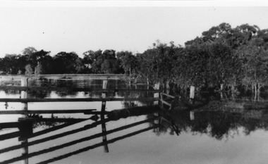
It shows the Plenty river in Greensborough in flood and the bluestone bridge at the bottom of the Main Street hill.The bluestone bridge was built in the mid 1860's and was demolished 1970's.A black and white photograph of a bridge over a river in flood.Nilgreensborough, plenty river, floods, bridges, bluestone -
 Wodonga & District Historical Society Inc
Album - Ringer's River by Des Martin - Plate 29 - Keiran drowns
A flash flood caused by the cloudburst upstream catches them all in the river and Keiran is drowned.The album and images are significant because they document literature written by a prominent member of the Wodonga community. The presentation of this precis was supported by several significant district families and individuals.Ringer's River Album Coloured photo Plate 29des martin, many a mile, ringer's river, northeast victoria stories -
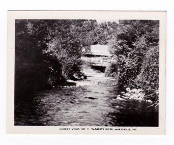 Marysville & District Historical Society
Photograph (item) - Black and white photograph, Murray Views, Murray Views No. 11. Taggerty River, Marysville, Vic, Post 1929
An early black and white photograph of the Steavenson River in Marysville, Victoria.An early black and white photograph of the Steavenson River in Marysville, Victoria. The Steavenson Falls is named after the Victorian Assistant Commissioner of Roads and Bridges, John Steavenson who arrived here in the early 1860s. This photograph was published by Murray Views in Gympie, Queensland, as a souvenir of Marysville.marysville, victoria, photograph, murray views, souvenir, steavenson river, john steavenson -
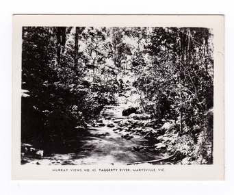 Marysville & District Historical Society
Photograph (item) - Black and white photograph, Murray Views, Murray Views No. 45. Taggerty River, Marysville, Vic, Post 1929
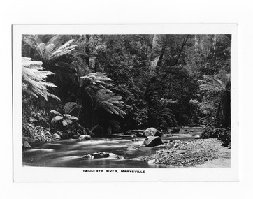
An early black and white photograph of the Taggerty River in Marysville, Victoria. An early black and white photograph of the Taggerty River in Marysville, Victoria. This photograph was produced by Murray Views in Gympie, Queensland as a souvenir of Marysville.taggerty river, marysville, victoria, murray views, photograph, souvenir -
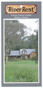 Marysville & District Historical Society
Flyer (item) - Accommodation flyer, 'River Rest', Unknown
An information flyer regarding accommodation at River Rest cottage in Buxton.An information flyer regarding accommodation at River Rest cottage in Buxton.buxton, victoria, australia, river rest country cottage, accommodation, flyer -
 Wodonga & District Historical Society Inc
Photograph - The River Port of Red Bank
THE RIVER PORT OF REDBANK During the 1870s, Red Bank would have been one of the busiest ports on the Murray River. When the railway line was being built from Melbourne to Wodonga all the railway material was brought up river from Echuca by paddle steamer and barge and unloaded at Red Bank. The material was loaded onto horse teams or bullock wagons and taken along the route of the spur line. During the 187 MacCulloch & Co. handled 3000 tons of railway material here' The port was operational from approximately 1870 until 1874. THE FIG TREES The fig trees and a small bank of gravel are the only visible reminders of where the spur line from the wharf at Red Bank met the main line. It was at this point that all the material for the mainline was transferred from the small locomotives and wagons from Red Bank. It would have been carried by bullock wagons and horse teams and unloaded at different places as the line progressed. After the line was completed in 1873 the fettlers from Wodonga would patrol this length of the line.These images are significant because they document an important stage in the development of transportation in North East Victoria.Images of the River Port of Red bank near Wodonga on the Murray River. 1. The wharf 2. All that remainsred bank port, historic wharf wodonga, river transport -
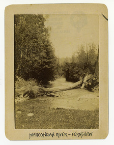 Marysville & District Historical Society
Photograph (Item) - Black and white photograph, Maroondah River - Fernshaw, c1900
An early black and white photograph of the Watts River at Fernshaw. The photograph has been incorrectly labeled as the Maroondah River - Fernshaw.An early black and white photograph of the Watts River at Fernshaw. The photograph has been incorrectly labeled as the Maroondah River - Fernshaw.ARMSTRONG COLLECTION 42 STATION STREET/ SANDRINGHAM 3191/ TEL. (03) 9521 5442/ IAN M.L. ARMSTRONG OAMwatts river, fernshaw, maroondah river, victoria -
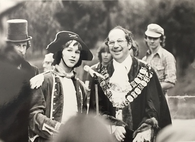 Kew Historical Society Inc
Photograph, Standard Newspapers, Charles Grimes Re-enactment, Yarra River, 1978
The party of the British surveyor Charles Grimes were the first Europeans to view the River Yarra, as it was later to be named. Members of the party reached the area now known as Studley Park in 1803. This local re-enactment commemorated 175 years since that event. Charles Grimes Re-Enactment, Yarra River, Kew, 1978. The photograph is of a student of Trinity Grammar School and the Mayor of Kew, Cr. Whiting. Inscription on reverse: "KH-161. Society's contribution to the 1978 Festival of Kew. Re-enactment of first white man's journey and discovery of the Yarra River and the area now know (sic) as Kew. 1978. This was in the year 1903 when Grimes and party came upon the Yarra to seek a possible site for a new convict settlement. Cr. Whiting, Mayor of Kew, receiving the report from Grimes, 'Andrew Allen'. Cr. Hutchinson in top hat 'town cryer'. Bush band in backround." Ripped stamp on reverse: "Standard N[ewspapers]."charles grimes re-enactment, trinity grammar school, cr whiting -- mayors -- kew (vic.), yarra river, andrew allen, kew historical society -
 Marysville & District Historical Society
Photograph (Item) - Black and white photograph, Fred Kruger, Scene on the Watts River near Fernshaw, Unknown
A copy of a black and white photograph on the Watts River near Fernshaw in Victoria.A copy of a black and white photograph on the Watts River near Fernshaw in Victoria taken by Fred Kruger. Fred Kruger (born Johan Friedrich Carl Kruger, 18 April 1831 – 15 February 1888) was a German-born photographer noted for his early photography of landscape and indigenous peoples in Victoria, Australia. Fernshaw was a rural township 63 km northeast of Melbourne and 10 km northeast of Healesville. Situated on the Watts River, near where a log had fallen making a convenient crossing, Fernshaw was settled in the 1860s. It provided good country for orchards and berry growing. The location was at the foot of Blacks Spur, with Mounts Juliet and Mondah rising on either side, providing spectacular scenery. There were nearby fern gullies giving rise to the name – ‘shaw’ is old English for thicket or wood. By 1875 Fernshaw had a post office (1865), two hotels, a school (1871), and stores. It was famed for its beauty, attracting tourists. In 1886 the Melbourne and Metropolitan Board of Works began work on the Watts River water catchment scheme – later to become Maroondah – and the Board obtained approval for the catchment country to be reserved and kept free of settlement. This required the removal of the Fernshaw township, which was completed by about 1890.fernshaw, watts river, victoria, fred kruger, photograph -
 Orbost & District Historical Society
black and white photograph, 1884?
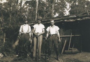
James Alexander Robertson was born 14th June, 1855, at Pentridge. the Coburg area which was known as Pentridge at the time, and prior to the building of the gaol. His parents were James Thomson Robertson and Esther (nee Hale), At age 20 James became the first selector on the Snowy River at Lochend. He took up Lots 1, 2 and 3, in the Parish of Newmerella in 1875; with his selection being ratified on May 1st, 1876. The selection included hill and river flat land in the area near where Icy Creek enters the Snowy River. James gradually improved and farmed the property; he cleared and drained Icy Creek and constructed the first known flood-gate on the Snowy River. To meet his farming commitments he supplemented his income by working on the construction and maintenance of roads and drains in the Newmerella area. He gained a contract with the Bairnsdale Shire council to construct the first road cutting down Burn’s Hill at Newmerella. His tender was for £16 ($32), and it took him, with four others, two months to complete the contract. He was single, and, after his untimely death at aged 29, in 1884, his parents and surviving unmarried sisters and brothers moved from Sarsfield to take over his selection at Lochend. (more information Newsletter April 2013)James Robertson was the first selector of land at Lochend, Orbost.A small black / white portrait photograph, oval shaped with a white background. It is of a middle-aged man with a full beard and moustache.on front at bottom - typed in black -:"James Alexander Robertson, Late of Lochend, Snowy River"robertson-james-alexander lochend-robertson -
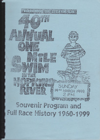 Warrnambool and District Historical Society Inc.
Work on paper - Report, Warrnambool Surf Lifesaving Club, 40th Annual One Mile Swim of the Hopkins River, 1999
The Hopkins River One Mile Swim started in 1960 as part of an Aquatic Day to raise funds for the Warrnambool Olympic Pool. Since 1961 a measured One Mile Course (1600 metres) was used, the course being up river for approx. 286 metres, then to the bridge and back to the jetty to the finishing line. It was a handicap race. The race was abandoned after 46 years (2005). The booklet is of some importance as it gives the details of the Hopkins River One Mile Race, an event that was a prominent one in Warrnambool for 46 years. The booklet records the achievements of the competitors and the work of the committees involved and will be useful for researchers. This is a booklet containing a souvenir program for the 40th Annual One Mile Swim in the Hopkins River in 1999 and a Full Race History from 1960 to 1999. It has been produced in-house by the Warrnambool Surf Lifesaving Club and has a blue cardboard front cover and a grey back cover. The photocopied and typed pages have been bound with black plastic. The contents include newspaper cuttings, photocopies of photographs, lists of winners and a list of the race’s sponsors. There are three loose sheets.Front Cover: Warrnambool Surf Lifesaving Club, 40th Annual One Mile Swim in the Hopkins River, Sunday 14th March 1999, 2 p.m., Souvenir Program and Full Race History 1960-1999warrnambool surf lifesaving club, hopkins river mile swim, hopkins river -
 Lakes Entrance Historical Society
Photograph - Gippsland Heritage Journal No 25 2004 copy in Police dropfile, 1940
three police officers at CRB Camp Martins Creek while searching for Snowy River Bandit Martins Creek Victoria - Story by R Haldane in Gippsland Heritage Journal No 25 2004 copy in Police dropfileBlack and white photograph of three police officers at CRB Camp Martins Creek while searching for Snowy River Bandit Martins Creek Victoriapolice, law and order -
 Orbost & District Historical Society
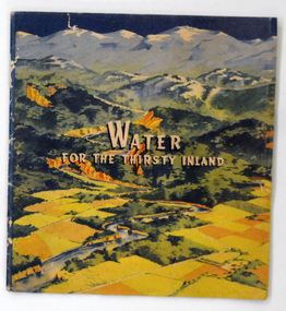
book, Water For the Thirsty Inland, 1945
Water For the Thirsty Inland was published by The Murrumbidgee Valley Water Users Association as a case for diversion of part of the Snowy River waters to the Murrumbidgee. In 1950 The Murrumbidgee Valley Water Users Association and the League established the Murray-Murrumbidgee Development Committee to ensure the Snowy Scheme was completed.This book is a significant research tool for the history of the diversion of the Snowy River.A 44 pp book, titled Water For The Thirsty Inland. On the front cover is a coloured print of a painting of a river (Snowy River?) from the mountains to the flats. The text of the title is white with a black shadow. The book contains b/w photographs and the print is black and green.Some pencilled notes on back.snowy-river murrumbidgee-valley-water-users' irrigation -
 Orbost & District Historical Society
black and white photograph
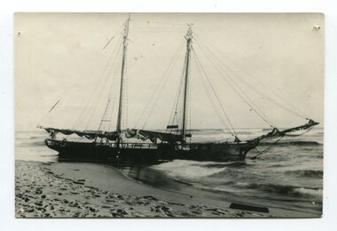
The “Glengarry” beached at Marlo The schooner Glengarry was a well-known trader on the Gippsland coast and had been stranded on a number of previous occasions including at the Natural Entrance joining the Gippsland Lakes to Bass Strait – Ninety Mile Beach, Lakes Entrance, c 1877 . In May 1898, the vessel struck a submerged object while crossing the Snowy River bar at Marlo and was beached, eventually becoming a total loss. Until t he railway came to East Gippsland goods were shipped from Marlo to Melbourne. This is a pictorial record of a well-known trading ship involved in that river transport.Three copies of a black / white photograph of the Schooner Glengarry wrecked in 1891 at the Snowy River entrance at Marlo.schooner-glengarry shipping transport-orbost -
 Orbost & District Historical Society
postcard, C1920-1940
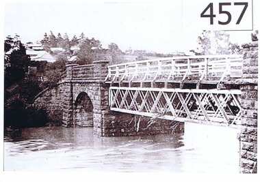
This photograph shows the second major bridge across the Snowy River at Orbost. The current Snowy River bridge is the fourth to provide a crossing to the township of Orbost. The first, in 1891, lasted just two years before it succumbed to flood waters. The bridge in this photograph was built in the 1920s as a road and rail bridge, and was again partly washed away by flood waters in 1934. After the end of the first World War the Victorian Railways considered an extension of the railhead across the river at Orbost, and in 1922 a new timber and steel girder structure, a joint Country Roads Board — Victorian Railways venture, was built and completed at a cost of £41,000 (the steel girders came from the Flinders Street viaduct reconstruction). Subsequently it was decided not to take the railway across the river, and the bridge was only used by road traffic. It was severely battered by floods during its life. and after the 1971 floods was eventually replaced by the current bridge in 1975. (info from Newletter 54N by John Phillips) This item is an early pictorial record of the previous Snowy River bridge at Orbost.A postcard with a black / white photograph of a bridge - timber and steel girder structure - across the Snowy River at Orbost, Reflections of the bridge are seen in the water.snowy-river-bridge-orbost -
 Robin Boyd Foundation
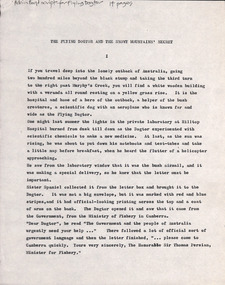
Document - Script, Robin Boyd, The Flying Dogtor and The Snowy Mountain's Secret. Adventure No. 6, The Lake Monsters, Episodes 44-52, 1963
This transcript outlines the storyline of the final adventure (no. 6) of The Flying Dogtor (The Lake Monster) in 4 chapters, episodes 44-52. The Dogtor is called to the Snowy Mountains Scheme to solve the mystery of a sea-serpent in Lake Eucumbene. After investigations around and under the water, he solves the mystery and is finally awarded suitably in Canberra.The Flying Dogtor" series was broadcast on Australian Television Network (later becoming the Seven Network) between February and April 1964 (see item D254 for schedule).Typewritten, quarto, carbon copy, 14 pagesOn top left 'Robin Boyd script for Flying Dogtor 14 pages' in Penleigh Boyd's handwriting.the flying dogtor, snowy mountains, robin boyd, crawford productions, manuscript -
 Queenscliffe Maritime Museum
Pamphlet - Clyde River Scotland, Pamphlets, brochures and news article re travelling on the Clyde River Scotland
Clyde River boats ScotlandClyde River boatsColourt & B&W brochures, pamphlets & news article re boats on the Clyde River Scotland.Reverse " NIL "historical references -
Tatura Irrigation & Wartime Camps Museum
Book, The River Murray, 1990
Written to record history of River Murray from aboriginal times, early settlers, riverboats, maps, irrigation, agriculture.Map of Murray River and districts on front cover. 4 river scenes in square boxes. Gold disc, paddle steamer, names of 3 states. Early scenes n back cover. 1 present day.irrigation, books, reference, rural, industry -
 Greensborough Historical Society
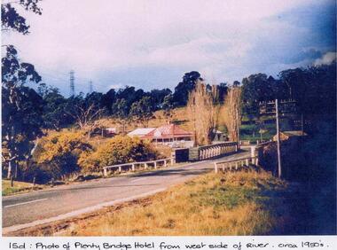
Photograph - Digital image, Plenty Bridge Hotel from west side of river, 1950s
Colour photograph of Plenty Bridge Hotel (Lower Plenty) from west side of river. Also shows bluestone bridge over Plenty River at Lower Plenty.Digital copy of colour photograph.On front of photograph: "15d Plenty Bridge Hotel from west side of river circa 1950s"lower plenty, plenty bridge hotel -
 Charlton Golden Grains Museum Inc
Photograph, B/W photograph of Flooded Billabong Cadrows Dairy in the bend of the Avoca River
Flooded Billabong Cadrows Dairy in the bend of the Avoca River, Charlton, VictoriaB/W photograph of Flooded Billabong Cadrows Dairy in the bend of the Avoca River, Charlton, Victoriaflood, charlton, avoca river, cadgow -
 Marysville & District Historical Society
Photograph (item) - Black and white photograph, Rose Stereograph Company, Taggerty River, Marysville, 1913-1967
A black and white photograph of the Taggerty River in Marysville in Victoria.A black and white photograph of the Taggerty River in Marysville in Victoria. The photograph was also used to produce the Rose Series postcard P. 2337.taggerty river, marysville, victoria, p. 2337, rose series postcard, postcard, souvenir -
 Lakes Entrance Historical Society
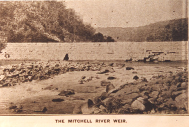
Photograph - Mitchell River Weir, Glenaladale Victoria, 1900 c
The Mitchell River Weir was commenced in 1900 work continued until almost completed, Foundation stone laid in March 1893 but the extensive flood damage in December 1893 ended the high hopes of the planners.Sepia toned photograph of weir on the Mitchell River at Glenaladale Victoriatopography, waterways, weir's -
 Orbost & District Historical Society
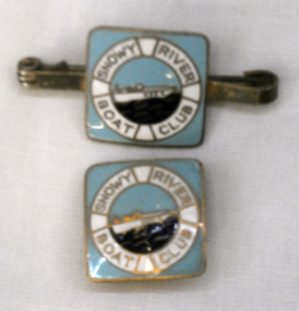
badges, 1950's
Snowy River Boat Club was formed in 1950. It was for power boats. By 1956 the Snowy River Club had been reformed and joined the Gippsland Group.This item reflects the popularity of water-based recreation in the Marlo area.Two small square shaped metal badges. 2274.1 has a pin at the back for attachment. 2274.2 is a stud type. Both has an enamel painted pale blue background, a white circle with "Snowy River Boat Club" around a smaller circle with a white boat on a dark blue sea.badge snowy-river-boat-club recreation boating water-sports -
 Lakes Entrance Historical Society
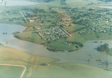
Photograph - Mitchell River in flood Bairnsdale Victoria, 1/04/1990 12:00:00 AM
There was a deluge overnight in headwaters of Mitchell and Avon Rivers so the rivers rose overnight and flooded low lying areasColour aerial photograph of Mitchell River in flood showing Clifton Waters Village in centre and township of Wy Yung near Bairnsdale Victoriarivers, floods -
 Wodonga & District Historical Society Inc
Album - Ringer's River by Des Martin - Plate 26 - Erin learns of Police party arriving
Erin O'Hara is buying material at Rosenthal's store in Overton when she learns that a special police party has come off the afternoon train to trap Daylight and Keiran with the mob of cattle they are bringing across the river that day. Margaret Wehner as Miss. Rosenthal.The album and images are significant because they document literature written by a prominent member of the Wodonga community. The presentation of this precis was supported by several significant district families and individuals.Ringer's River Album Coloured photo Plate 26des martin, many a mile, ringer's river, northeast victoria stories -
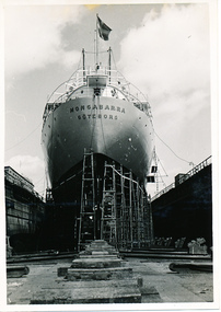 Mission to Seafarers Victoria
Photograph - Photograph, Black and white, Allan Charles Quinn, M/S "Mongabarra" in dry-dock at Eriksbergs, 1950
This series of photographs captures life at sea and the conditions on the ship M/S "Mongabarra" in 1950. This photograph was reproduced and exhibited by the Mission to Seafarers as part of the exhibition "Letters from Abroad" in 2012.This photograph is part of the Allan Quinn collection, which is a pictorial autobiography, and it represents one of many moments of his time abroad as a seafarer.Black and white photograph of the M/S "Mongabarra" Goteborg in Eriksbergs dockyard, Gothenburg, Sweden. The ship is directly in the middle of the photograph taking from the very front of the ship in the dry-dock. There are several ladders lined up along the left-hand side of the ship beginning from the ships front. There are several wooden planks lying on the ground in front of the ship and walls either side of the ship.ship, sweden, mongabarra, allan quinn collection, allan quinn, gothenburg, drydock, shipyard, dockyard, eriksbergs, letters-from-abroad