Showing 408 items
matching south court
-
 Buninyong & District Historical Society
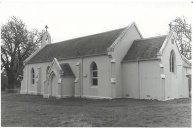
Photograph - Original B/W Photograph, Clive Brooks, Roman Catholic Church, Fisken St. Buninyong, 19 Jul 1993
Gold rush church, subdued Victorian Gothic design, white-washed render, slate roof. B/W photo of St. Peter and St. Paul's Catholic Church, Fisken St. Buninyong, south facadebuninyong, catholic church, building, gothic revival, fisken st. -
 Buninyong & District Historical Society
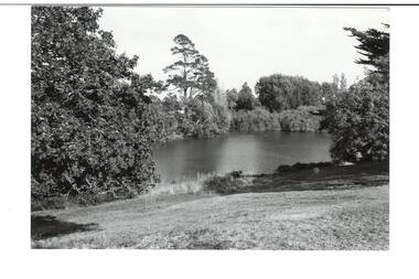
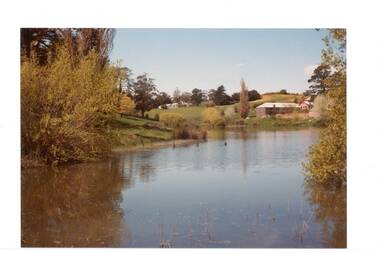
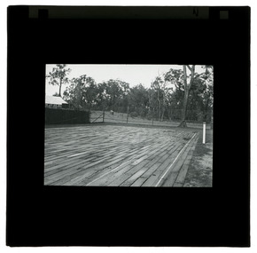
Photograph - B/W photograph, View of the Gong, April 1994
The Gong has been part of the Buninyong industrial, cultural and recreational history pre and post 1837Fed by springs, the Gong has been a major source of water for industrial, pastoral, recreational uses and local wildlifeBlack and white photograph of the Gong, view from Scott Street to the South West cornerbotanic gardens, landscape, industry, water supply, springs -
 Buninyong & District Historical Society
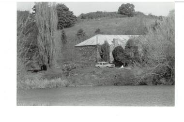
Photograph - Original B/W Photograph, Clive Brooks, Old Brewery, Buninyong, 6 Sep 1993
Part of series to record changes in BuninyongB/W photo old Buninyong Brewery, south east of Gong, formerly Sheppard's Brewerybuninyong, brewery, sheppard -
 Buninyong & District Historical Society
Photograph - Original B/W Photograph, Clive Brooks, View from Catholic Church, Buninyong, south-east towards "Brim Brim.", 19 July 1993
Part of series to record changes in BuninyongB/W photo View from Catholic Church, Buninyong, south-east towards "Brim Brim'" across fieldsbuninyong, church, landscape, brim brim -
 Buninyong & District Historical Society
Photograph - Original Colour Photograph, Clive Brooks, View of The Gong, looking South East, 1982
Record of Gong 1980's.Colour photo, view looking S.E. of the Upper Dam, also known as The Gong,. Buildings, upper left hoiuse of T. Attwood, Market Gardener, 1860; Centre bluestone former brewery 1854 and behind extension 1980.gong, reservour, brewery, attwood -
 Buninyong & District Historical Society
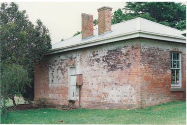
Photograph - Original Photograph, Clive Brooks, 1859 Buninyong Police Residence/Station, former Legal Precinct, Cornish St., from south, 9 Nov. 1991
detail of historic buildingColour photo 1859 Buninyong Police Residence/Station, former Legal Precinct, Cornish St., from southbuninyong, police station, legal precinct, cornish st. -
 Buninyong & District Historical Society
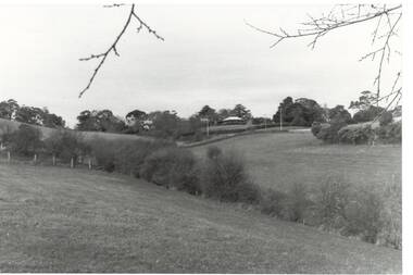
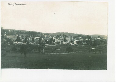
Photograph - Photo of Original Photograph, View of Buninyong looking down from south east around 1900, 1993
hidtoric recordCopy of B/W Photograph, View of Buninyong looking down from south east around 1900 across fields and wetland.buninyong, view -
 Kew Historical Society Inc
Plan, Melbourne & Metropolitan Board of Works : Borough of Kew : Detail Plan No.1588, 1904
The Melbourne and Metropolitan Board of Works (MMBW) plans were produced from the 1890s to the 1950s. They were crucial to the design and development of Melbourne's sewerage and drainage system. The plans, at a scale of 40 feet to 1 inch (1:480), provide a detailed historical record of Melbourne streetscapes and environmental features. Each plan covers one or two street blocks (roughly six streets), showing details of buildings, including garden layouts and ownership boundaries, and features such as laneways, drains, bridges, parks, municipal boundaries and other prominent landmarks as they existed at the time each plan was produced. (Source: State Library of Victoria)This plan forms part of a large group of MMBW plans and maps that was donated to the Society by the Mr Poulter, City Engineer of the City of Kew in 1989. Within this collection, thirty-five hand-coloured plans, backed with linen, are of statewide significance as they include annotations that provide details of construction materials used in buildings in the first decade of the 20th century as well as additional information about land ownership and usage. The copies in the Public Record Office Victoria and the State Library of Victoria are monochrome versions which do not denote building materials so that the maps in this collection are invaluable and unique tools for researchers and heritage consultants. A number of the plans are not held in the collection of the State Library of Victoria so they have the additional attribute of rarity.Original survey plan, issued by the MMBW to a contractor with responsibility for constructing sewers in the area identified on the plan within the Borough of Kew. The plan was at some stage hand-coloured, possibly by the contractor, but more likely by officers working in the Engineering Department of the Borough and later Town, then City of Kew. The hand-coloured sections of buildings on the plan were used to denote masonry or brick constructions (pink), weatherboard constructions (yellow), and public buildings (grey). This plan shows the original configuration of the Kew Post Office, Court House and Police Station, which had opened in 1888. This configuration was to essentially remain until the purchase of the Court House and Police Station by the City of Boroondara in 2007 and its subsequent renovation. Interestingly, the MMBW surveyors incorrectly labelled parts of the complex. In the triangle in front of the Post Office, before the erection of the Kew Cenotaph in 1925, was located a lawn and the Queen Victoria Jubilee Fountain. While many of the shops on the south side of High street had been constructed by 1903 a number of sites were still used as vegetable gardens. Further along High Street, on the corner of Charles Street, the Salvation Army Barracks can be seen on the plan. These Barracks predate the later Citadel and ‘Young People’s Hall’ that were opened in 1919. At 22 Charles Street can be seen the house of James Venn Morgan. Hailed as the ‘father of Kew’, Morgan arrived in Melbourne in 1840. He was first engaged as a bookmaker, but a fortunate venture on the goldfields enabled him to purchase land in Kew. He conducted a market garden and dairy in Kew for many years.melbourne and metropolitan board of works, detail plans, maps - borough of kew, mmbw 1588, cartography -
 Kew Historical Society Inc
Photograph, J F C Farquhar, Wellington Street From High Street, 1891
At the beginning of the 1890s, the Kew businessman and Town Councillor, Henry Kellett, commissioned J.F.C. Farquhar to photograph scenes of Kew. These scenes included panoramas as well as pastoral scenes. The resulting set of twelve photographs was assembled in an album, Kew Where We Live, from which customers could select images for purchase.The preamble to the album describes that the photographs used the ‘argentic bromide’ process, now more commonly known as the gelatine silver process. This form of dry plate photography allowed for the negatives to be kept for weeks before processing, hence its value in landscape photography. The resulting images were considered to be finely grained and everlasting. Evidence of the success of Henry Kellett’s venture can be seen today, in that some of the photographs are held in national collections.It is believed that the Kew Historical Society’s copy of the Kellett album is unique and that the photographs in the book were the first copies taken from the original plates. It is the first and most important series of images produced about Kew. The individual images have proved essential in identifying buildings and places of heritage value in the district.Very few of the natural or built features in this panoramic photograph of Wellington Street remain. The open land between High Street South and Denmark Street, then known as O’Shannessy’s Paddock, was to become a residential subdivision at the beginning of the 20th Century. On the far side of Denmark Street, bordered by a picket fence, is the Kew Railway Station (demolished 1957). Further east, the large building with the flagpole is the Kew Recreation Hall (demolished 1960), which was the centre of civic life for almost a century. The building was used for dances, civic functions and exhibitions. A bowling green, tennis courts, and a cricket ground surrounded the Hall. The dominant building in the photograph is Xavier College, founded in 1872 by the Society of Jesus. The first classes for pupils were held in 1878. It is presumed that Farquhar used its roof for two of his bird’s eye views.Wellington Street from High Streetkew illustrated, kew where we live, photographic books, henry kellett -
 Kew Historical Society Inc
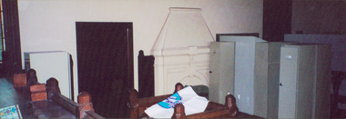
Photograph - Former Kew Court House : Court Room, 1996
A civic campaign for new public offices developed in Kew in the 1880s. After much deliberation, the location chosen was the junction of Bulleen and Cotham Roads. The buildings were designed by George Watson and John Henry Harvey, architects within the Department of Public Works (Victoria). Building was commenced in 1887, and after one year, the buildings were opened. The Post Office was transferred to the new Commonwealth Government in 1901. The Police Station and Court House, sold by the Victorian Government to the City of Boroondara in 2007, are now a community cultural centre and performing arts venue.The buildings were listed on the Victorian Heritage Register Register (HO885) in 1991. They are historically and architecturally significant to the State of Victoria because Watson and Harvey's designs exhibit diversity in integrating civil offices, they accommodate the apex of road junctions, and they demonstrate a departure from the contemporaneously favoured High Victorian Classical to the Queen Anne style in the design of civic buildings.View of south wall of the former Kew Court House, which when the photo was taken had been converted into a section of the Kew Police Station, and used as a briefing and locker room.kew court house, kew police station -- high street -- kew (vic.), public offices -- kew (vic) -
 Kew Historical Society Inc
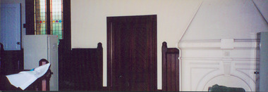
Photograph - Former Kew Court House : Court Room, 1996
A civic campaign for new public offices developed in Kew in the 1880s. After much deliberation, the location chosen was the junction of Bulleen and Cotham Roads. The buildings were designed by George Watson and John Henry Harvey, architects within the Department of Public Works (Victoria). Building was commenced in 1887, and after one year, the buildings were opened. The Post Office was transferred to the new Commonwealth Government in 1901. The Police Station and Court House, sold by the Victorian Government to the City of Boroondara in 2007, are now a community cultural centre and performing arts venue.The buildings were listed on the Victorian Heritage Register Register (HO885) in 1991. They are historically and architecturally significant to the State of Victoria because Watson and Harvey's designs exhibit diversity in integrating civil offices, they accommodate the apex of road junctions, and they demonstrate a departure from the contemporaneously favoured High Victorian Classical to the Queen Anne style in the design of civic buildings.View of south wall of the former Kew Court House, which when the photo was taken had been converted into a section of the Kew Police Station, and used as a briefing and locker room.Nilkew court house, court room -- victoria, public office - kew (vic.) -
![Escol Estate [Kew], 1940](/media/collectors/550653872162f11fb04854aa/items/59115843d0ce2b1f048f0fbb/item-media/591158fdd0ce2e1f04f1e0f5/item-fit-380x285.jpg) Kew Historical Society Inc
Kew Historical Society IncPlan - Subdivision Plan, Escol Estate [Kew], 1940, 1940
... Court, which runs south from Sackville Street between Evans Road...’ was a subdivision, which created Bramley Court, which runs south from ...Pru Sanderson, in her groundbreaking ‘City of Kew Urban Conservation Study : Volume 2 - Development History’ (1988), summarised the periods of urban development and subdivisions of land in Kew. The periods that she identified included 1845-1880, 1880-1893, 1893-1921, 1921-1933, 1933-1943, and Post-War Development. These periods were selected as they represented periods of rapid growth or decline in urban development. An obvious starting point for Sanderson’s groupings involved population growth and the associated economic cycles. These cycles also highlighted urban expansion onto land that was predominantly rural, although in other cases it represented the decline and breakup of large estates. A number of the plans in the Kew Historical Society’s collection can also be found in other collections, such as those of the State Library of Victoria and the Boroondara Library Service. A number are however unique to the collection.The Kew Historical Society collection includes almost 100 subdivision plans pertaining to suburbs of the City of Melbourne. Most of these are of Kew, Kew East or Studley Park, although a smaller number are plans of Camberwell, Deepdene, Balwyn and Hawthorn. It is believed that the majority of the plans were gifted to the Society by persons connected with the real estate firm - J. R. Mathers and McMillan, 136 Cotham Road, Kew. The Plans in the collection are rarely in pristine form, being working plans on which the agent would write notes and record lots sold and the prices of these. The subdivision plans are historically significant examples of the growth of urban Melbourne from the beginning of the 20th Century up until the 1980s. A number of the plans are double-sided and often include a photograph on the reverse. A number of the latter are by noted photographers such as J.E. Barnes.The ‘Escol Estate’ was a subdivision, which created Bramley Court, which runs south from Sackville Street between Evans Road and Orford Avenue. The subdivision was comprised of 12 lots. At the auction of the lots in May 1940, eight of the 12 allotments were sold. The land was sold subject to a restriction of only one private residence being erected on each lot.subdivision plans - kew, sackville street – kew (vic.), bramley court – kew (vic.) -
 Kew Historical Society Inc
Plan - Subdivision Plan, J R Mathers & McMillan, Clutha Subdivision, 1940
Pru Sanderson, in her groundbreaking ‘City of Kew Urban Conservation Study : Volume 2 - Development History’ (1988), summarised the periods of urban development and subdivisions of land in Kew. The periods that she identified included 1845-1880, 1880-1893, 1893-1921, 1921-1933, 1933-1943, and Post-War Development. These periods were selected as they represented periods of rapid growth or decline in urban development. An obvious starting point for Sanderson’s groupings involved population growth and the associated economic cycles. These cycles also highlighted urban expansion onto land that was predominantly rural, although in other cases it represented the decline and breakup of large estates. A number of the plans in the Kew Historical Society’s collection can also be found in other collections, such as those of the State Library of Victoria and the Boroondara Library Service. A number are however unique to the collection.The Kew Historical Society collection includes almost 100 subdivision plans pertaining to suburbs of the City of Melbourne. Most of these are of Kew, Kew East or Studley Park, although a smaller number are plans of Camberwell, Deepdene, Balwyn and Hawthorn. It is believed that the majority of the plans were gifted to the Society by persons connected with the real estate firm - J. R. Mathers and McMillan, 136 Cotham Road, Kew. The Plans in the collection are rarely in pristine form, being working plans on which the agent would write notes and record lots sold and the prices of these. The subdivision plans are historically significant examples of the growth of urban Melbourne from the beginning of the 20th Century up until the 1980s. A number of the plans are double-sided and often include a photograph on the reverse. A number of the latter are by noted photographers such as J.E. Barnes.The subdivision plan for the Clutha Subdivision is one of the largest in the Society’s collection. The plan includes a map of the proposed allotments, photographic views to the north and south, and information about the kinds of buildings that could be constructed on the allotments. The subdivision was bounded by Studley Park Road, and Carson, Stevenson and Edgecombe Streets. Two new streets, Mackie Court and Younger Street were created as part of the subdivision. The subdivision took its name from ‘Clutha’, the home of John Carson, who was to become Mayor of Kew in 1863. A Report to the City of Boroondara outlined how: ‘The Clutha estate was progressively developed from 1940, with new houses under construction on the Studley Park Road, Carson and Edgecombe Street frontages by 1941. By 1943, directory listings were available for all addresses with the exception of Mackie Court. Building ceased after the government’s prohibition on civilian building was enforced from 1942, with little change in listings until the 1950s when the remainder of the subdivision was developed’."H"subdivisions - kew - studley park, clutha subdivision, studley park road -
 Kew Historical Society Inc
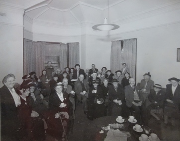
Photograph - Kew Elder Citizens' Club, Lyons 'Mountain Grand' Warburton, Unknown, 1978
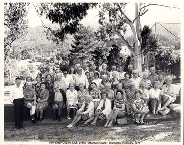
The orthodox version of the origins and history of the Kew Elder(ly) Citizens’ Association was established by Cr. W. D. Vaughan in his book Kew’s Civic Century (1960), when he wrote that: "When Mrs. C. H. Simpson was Mayoress in 1952 she set up the Elderly Citizens’ Association to care for the needs of ages persons in Kew. The idea was strongly supported and a start was made by providing social afternoons for elderly folk at Southesk. Visiting sick people in their homes, providing firewood where needed, and other activities were undertaken by the Association. The aid of Council was sought to further the work. It was decided that a social unit for elderly folk be established at Southesk." (p.126-7). In the following pages, he describes in detail Council’s role in formally establishing the Association. This ‘official’ version was reasserted in the later Thematic Environmental History of the City of Boroondara (2012). However the origins and gestation of community of organisations is rarely straightforward. In 1965, five years after Vaughan’s book was published, the author of East Kew Women’s Club : Twenty Years : 20-7-1945-30-7-1965, writing about the period July 1947 to July 1950, described the role the Club played in establishing the Kew Elder Citizens Association. The author wrote: "At a meeting of the Kew Community Aid, the plight of many elderly people in Kew who were dependent on pensions was raised and in order to ascertain their needs the practice was begun of serving morning tea at the Masonic Hall in Walpole Street, where pensions were then paid. From this beginning the Kew Elder Citizens Association was formed in Kew with wide support, and Club members gave willing support on the committee, in helping serve afternoon tea and in entertainment." (p.4) Photographic evidence also leads to questions about Vaughan’s version of events. A framed photograph in the Society’s Collection shows a Public Meeting to form the Kew Elder Citizens Association in a room at Southesk a year earlier in 1951. Whatever version of the origins of the Association is correct, a later framed photograph in the Society’s collection shows the opening of the completed Clubrooms of the Kew Elder Citizens at South Esk by the Hon. E.P. Cameron M.L.C, Minister of Health, on 12 November 1956. The Association is still active in Kew and is currently located at Hamer Court, opposite the Boroondara General (Kew) Cemetery in High Street, Kew.Framed and titled black and white photograph taken on the occasion of a visit by members of the Kew Elder Citizens Club to Lyons "Mountain Grand" Warburton, in February 1978.community groups -- kew (vic.), senior citizens clubs -- kew (vic), club tours -
 Kew Historical Society Inc
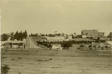
Photograph - Kew Junction, Herald & Weekly Times, 1962
... kew war memorial kew post office kew police station kew court ...This is an aerial oblique image looking north. It shows Kew Junction before construction of VicRoads (Country Roads Board), Murphy's (Leo's) supermarket, and office towers. It also shows a building on the land now known as the Raoul Wallenberg Reserve, the Kew Municipal Offices in Walpole Street, and St Paul's School for the Blind in Fernhurst Grove, and Kew Bowling Club in Wellington Street.An aerial photograph of Kew Junction, showing the intersection of High Street South, Studley Park Road, Princess Street, High Street and Denmark Street. A number of buildings, now demolished can be identified in the photo, including Jellis’ Bakeries on the corner of Princess Street and Studley Park Road." Annotation on reverse: "Kew Historical Society from Mr L. H. Chinner".kew junction, aerial photograph (kew), oblique aerial, st paul's school for the blind, kew municipal offices, high street kew, studley park road, kew war memorial, kew post office, kew police station, kew court house, high street south, kew, wellington street kew, denmark street kew -
 Kew Historical Society Inc
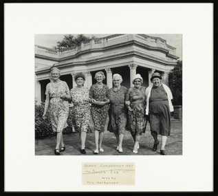
Photograph - Finalists in the 'Queen Competition' at Southesk, Kew Elder Citizens' Club, 1967
The orthodox version of the origins and history of the Kew Elder(ly) Citizens’ Association was established by Cr. W. D. Vaughan in his book Kew’s Civic Century (1960), when he wrote that: "When Mrs. C. H. Simpson was Mayoress in 1952 she set up the Elderly Citizens’ Association to care for the needs of ages persons in Kew. The idea was strongly supported and a start was made by providing social afternoons for elderly folk at Southesk. Visiting sick people in their homes, providing firewood where needed, and other activities were undertaken by the Association. The aid of Council was sought to further the work. It was decided that a social unit for elderly folk be established at Southesk." (p.126-7). In the following pages, he describes in detail Council’s role in formally establishing the Association. This ‘official’ version was reasserted in the later Thematic Environmental History of the City of Boroondara (2012). However the origins and gestation of community of organisations is rarely straightforward. In 1965, five years after Vaughan’s book was published, the author of East Kew Women’s Club : Twenty Years : 20-7-1945-30-7-1965, writing about the period July 1947 to July 1950, described the role the Club played in establishing the Kew Elder Citizens Association. The author wrote: "At a meeting of the Kew Community Aid, the plight of many elderly people in Kew who were dependent on pensions was raised and in order to ascertain their needs the practice was begun of serving morning tea at the Masonic Hall in Walpole Street, where pensions were then paid. From this beginning the Kew Elder Citizens Association was formed in Kew with wide support, and Club members gave willing support on the committee, in helping serve afternoon tea and in entertainment." (p.4) Photographic evidence also leads to questions about Vaughan’s version of events. A framed photograph in the Society’s Collection shows a Public Meeting to form the Kew Elder Citizens Association in a room at Southesk a year earlier in 1951. Whatever version of the origins of the Association is correct, a later framed photograph in the Society’s collection shows the opening of the completed Clubrooms of the Kew Elder Citizens at South Esk by the Hon. E.P. Cameron M.L.C, Minister of Health, on 12 November 1956. The Association is still active in Kew and is currently located at Hamer Court, opposite the Boroondara General (Kew) Cemetery in High Street, Kew.Historic early photograph from the archives of the Kew Elder Citizen's ClubFramed photograph of six women who it is presumed were the candidates or finalists in a competition to be the Queen of Southesk. At this time, Southesk in Cotham Road was home to the Kew Elder Citizens Club, now known as Kew Senior Citizens Centre Inc.Front mount: "Queen Competition 1967 - South Esk - Won by Mrs Harkansee." Reverse: "L-R: -. Miss Knox, Mrs Emmerson, Mrs Higgins, Mrs Moyle, Mrs Harkansee"kew elder citizens club, kew senior citizens centre inc., southesk, miss knox, mrs emmerson, mrs higgins, mrs moyle, mrs harkensee -
 Kew Historical Society Inc
Photograph - Opening of the Kew Elder Citizens Clubrooms at 'Southesk', City of Kew, 1954
The orthodox version of the origins and history of the Kew Elder(ly) Citizens’ Association was established by Cr. W. D. Vaughan in his book Kew’s Civic Century (1960), when he wrote that: "When Mrs. C. H. Simpson was Mayoress in 1952 she set up the Elderly Citizens’ Association to care for the needs of ages persons in Kew. The idea was strongly supported and a start was made by providing social afternoons for elderly folk at Southesk. Visiting sick people in their homes, providing firewood where needed, and other activities were undertaken by the Association. The aid of Council was sought to further the work. It was decided that a social unit for elderly folk be established at Southesk." (p.126-7). In the following pages, he describes in detail Council’s role in formally establishing the Association. This ‘official’ version was reasserted in the later Thematic Environmental History of the City of Boroondara (2012). However the origins and gestation of community of organisations is rarely straightforward. In 1965, five years after Vaughan’s book was published, the author of East Kew Women’s Club : Twenty Years : 20-7-1945-30-7-1965, writing about the period July 1947 to July 1950, described the role the Club played in establishing the Kew Elder Citizens Association. The author wrote: "At a meeting of the Kew Community Aid, the plight of many elderly people in Kew who were dependent on pensions was raised and in order to ascertain their needs the practice was begun of serving morning tea at the Masonic Hall in Walpole Street, where pensions were then paid. From this beginning the Kew Elder Citizens Association was formed in Kew with wide support, and Club members gave willing support on the committee, in helping serve afternoon tea and in entertainment." (p.4) Photographic evidence also leads to questions about Vaughan’s version of events. A framed photograph in the Society’s Collection shows a Public Meeting to form the Kew Elder Citizens Association in a room at Southesk a year earlier in 1951. Whatever version of the origins of the Association is correct, a later framed photograph in the Society’s collection shows the opening of the completed Clubrooms of the Kew Elder Citizens at South Esk by the Hon. E.P. Cameron M.L.C, Minister of Health, on 12 November 1956. The Association is still active in Kew and is currently located at Hamer Court, opposite the Boroondara General (Kew) Cemetery in High Street, Kew.Framed, inscribed photograph of the opening of the Kew Elder Citizens Club at Southesk in 1954. The ceremony would appear to be conducted on the western side of the house.‘Opening of the Kew Elder Citizens Clubrooms “South Esk” by the Hon. E.P. Cameron M.L.C, Minister of Health, 12.11.1956. Cr. W.A. Comeadow O.B.E., J.P. (Mayor).’southesk, kew elder citizens club, kew elderly citizens club, kew senior citizens club -
 Kew Historical Society Inc
Photograph - Public Meeting to Form Kew Elder Citizens' Club, City of Kew, 1951
The orthodox version of the origins and history of the Kew Elder(ly) Citizens’ Association was established by Cr. W. D. Vaughan in his book Kew’s Civic Century (1960), when he wrote that: "When Mrs. C. H. Simpson was Mayoress in 1952 she set up the Elderly Citizens’ Association to care for the needs of ages persons in Kew. The idea was strongly supported and a start was made by providing social afternoons for elderly folk at Southesk. Visiting sick people in their homes, providing firewood where needed, and other activities were undertaken by the Association. The aid of Council was sought to further the work. It was decided that a social unit for elderly folk be established at Southesk." (p.126-7). In the following pages, he describes in detail Council’s role in formally establishing the Association. This ‘official’ version was reasserted in the later Thematic Environmental History of the City of Boroondara (2012). However the origins and gestation of community of organisations is rarely straightforward. In 1965, five years after Vaughan’s book was published, the author of East Kew Women’s Club : Twenty Years : 20-7-1945-30-7-1965, writing about the period July 1947 to July 1950, described the role the Club played in establishing the Kew Elder Citizens Association. The author wrote: "At a meeting of the Kew Community Aid, the plight of many elderly people in Kew who were dependent on pensions was raised and in order to ascertain their needs the practice was begun of serving morning tea at the Masonic Hall in Walpole Street, where pensions were then paid. From this beginning the Kew Elder Citizens Association was formed in Kew with wide support, and Club members gave willing support on the committee, in helping serve afternoon tea and in entertainment." (p.4) Photographic evidence also leads to questions about Vaughan’s version of events. A framed photograph in the Society’s Collection shows a Public Meeting to form the Kew Elder Citizens Association in a room at Southesk a year earlier in 1951. Whatever version of the origins of the Association is correct, a later framed photograph in the Society’s collection shows the opening of the completed Clubrooms of the Kew Elder Citizens at South Esk by the Hon. E.P. Cameron M.L.C, Minister of Health, on 12 November 1956. The Association is still active in Kew and is currently located at Hamer Court, opposite the Boroondara General (Kew) Cemetery in High Street, Kew.Historic founding photograph of the Kew Senior Citizens AssociationFramed photograph of a meeting at Southesk in Cotham Road to form the Kew Elder Citizens Club. None of the individuals are named. The meeting was not held in the Drawing Room or Ballroom at Southesk as there is an absence of frescoes on the ceiling. The ceiling in the photograph is a cove ceiling however like that in the front two rooms.Handwritten caption: "Public Meeting to Form Kew Elder Citizens, 1951"kew elder citizens club, kew elderly citizens club, kew senior citizens club, southesk -
 RMIT GSBL Justice Smith Collection
Report, Kirby, Michael, The judiciary in federation centenary year - good news, bad news, no news : eleventh AIJA oration in judicial administration, 2001
... at The Banco Court, Supreme Court of New South Wales, Queen's Square... Court of New South Wales, Queen's Square, Sydney Friday 22 June ...Eleventh AIJA oration in judicial administration Delivered by The Hon. Justice Michael Kirby AC CMG High Court of Australia at The Banco Court, Supreme Court of New South Wales, Queen's Square, Sydney Friday 22 June 2001ISBN: 1875527435judges -- australia, judicial power -- australia -
 Kew Historical Society Inc
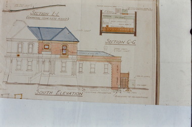
Slide - Architectural Drawing, Kew Public Offices, 1887
A civic campaign for new public offices developed in Kew in the 1880s. After much deliberation, the location chosen was the junction of Bulleen and Cotham Roads. The buildings were designed by George Watson and John Henry Harvey, architects within the Department of Public Works (Victoria). Building was commenced in 1887, and after one year, the buildings were opened. The Post Office was transferred to the new Commonwealth Government in 1901. The Police Station and Court House, sold by the Victorian Government to the City of Boroondara in 2007, are now a community cultural centre and performing arts venue.The buildings were listed on the Victorian Heritage Register Register (HO885) in 1991. They are historically and architecturally significant to the State Of Victoria because Watson and Harvey's designs exhibit diversity in integrating civil offices, they accommodate the apex of road junctions, and they demonstrate a departure from the contemporaneously favoured High Victorian Classical to the Queen Anne style in the design of civic buildings. 35mm colour transparency of an original plan by George Watson and John Henry Harvey, architects of the Department of Public Works (Victoria), in 1887 for New Public Offices at Kew. This plan was copied by the donor from an original held at the Commonwealth Archives in Brighton (Vic). The copy was made to illustrate a report that the donor made on ‘The functional planning design, building materials and construction methods of the Kew Post Office’ as part of course work at RMIT.SOUTH ELEVATION / SECTION L-L / SECTION G-Gkew court house, kew police station, kew post office, architectural drawings, khs - slides, new public offices -- kew (vic.), architecture — queen anne style -
 Sunbury Family History and Heritage Society Inc.
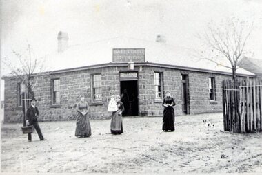
Photograph, Ball Court Hotel
The hotel was built some time shortly after 1842 by John Cahill, who arrived in the colony in 1842 from Thurles in Tipperary, Ireland. The building although much altered with render covering the original \blue stone structure is on the south-west corner of Macedon and Jackson Streets. The hotel was called the Ball Court because Cahill also had a hand-ball court set up behind the hotel.Originally five hotels were built along Macedon Street between Jackson Creek and Evans Street. The Ball Court Hotel is the only one still standing and operating as a hotel.A non-digital black and white photograph with a cream border of man and three ladies standing outside a single story blue stone hotel building with a corner entrance. AS well as the corner entrance there is another doorway on the RHS along with three narrow windows and three other windows on the other side. One of the ladies is holding a little child. Two trees surrounded by tree guards are on each side of the photograph.Ball Court Hotel, John Cahillball court hotel, hotels, sunbury, macedon street, jackson street, ball court -
 Stawell Historical Society Inc
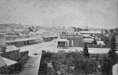
Photograph, Patrick Street and the Corner of Sloane Street with Stawell Court House in the background & St Patricks Church on the Horizon 1878
Patrick Street Sloane Street intersection in the 1880’s (Herbert Photo) On Big Hill side of Patrick Street is Matthew Cairns Plumber & Gasfitter, R. Greenwood Tailor, Mrs. Goodwin Cafe & Restaurant, Mack's Hotel, Grocer, Boot and Shoemaker, J. Farleys Auction Room, J.B. Wallis Royal Exchange Hotel, Stawell Court House and St Patricks Church in Distance On corner of Patrick and Sloane Streets, Melbourne Cash Store Wine Spirits & Provisions. In background mining poppet head behind livery stable. St Patrick Church in distance on right. 1878Patrick St, Sloane St intersection looking south . The Stawell Library now occupies this corner.Victorian Views. C. Herbert, Photo. Stawell 1878stawell business streetscape -
 National Wool Museum
Photograph - Rural Property, J W Allen, 1900 - 1940
This item is part of a collection of seven black and white glass lantern slides previously housed together in a glass plate box. The slides are part of a greater collection of around forty three black and white glass lantern slides, along with other photographs and photo albums related to this collection. This item is associated with the New South Wales Graziers Association world tour of merino sheep 1928/9. The slides were possibly used as supporting material in presentations made by J W Allen when on tour.Black and white glass lantern slide with paper edging showing a rural property with a court in the foreground.agriculture, new south wales graziers association, travel, sheep, breeding, photography, glass lantern slides, j w allen -
 Federation University Art Collection
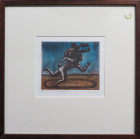
Work on paper - Printmaking -Aquatint etching, 'Dog' by Geoffrey Ricardo, 1995
GEOFFREY RICARDO Born 1964, Melbourne, Australia 1984-86 Bachelor of Arts (Fine Art), Printmaking, Chisholm Institute of Technology, Melbourne 1987-89 Printing Assistant at Bill Young Studios, Editioning intaglio prints, King Valley, VIC 1988 Full-time Studio Technician at Printmaking Department, Chisholm Institute of Technology, Melbourne 1989-90 Graduate Diploma (Fine Art), Printmaking, Monash University, Melbourne 1991 Traveled to England, France, Spain and USA (Winsor & Newton International Travelling Bursary, National Students Art Prize) Worked in private studios in Gaucin, Spain and New York, USA 1994-95 Master of Fine Arts, Monash University, Melbourne 1995 Guest Lecturer, Victorian College of the Arts, Melbourne Traveled to Europe and America 1996 Guest Lecturer, Royal Melbourne Institute of Technology, Melbourne 1990-98 Sessional Lecturer, Monash University, Melbourne 1998 Traveled to America and Mexico 2001-05 Sessional Lecturer, The Victorian College of the Arts, Melbourne 2003-10 Printmaking Workshops, Warrnambool TAFE, Warrnambool, VIC 2004 Traveled to Europe, Mexico and Cuba 2005 Lecturer, National Art School (Summer School), Sydney Sessional Lecturer, Monash University, Melbourne Lecturer, Institution of Koorie Education, Deakin University, Geelong, VIC SOLO EXHIBITIONS 2012 ‘Collection of Works’ The Art Vault Mildura ‘Deeper Meanings’, The Incinerator Gallery, Melbourne ‘Three Projects’, Australian Galleries, Glenmore Road, Sydney Melbourne Art Fair Stand F33, Australian Galleries, Melbourne 2009 ‘Anno Domino, Antarctica and The Anatomy Lesson’, Australian Galleries Derby Street, Melbourne The Art Vault, Mildura, VIC 2008 MV Orlova (Quark Expeditions), The Drake Passage, Antarctica 2007 ‘Herd’, BMGArt, Adelaide ‘Herd’, Australian Galleries Painting & Sculpture, Sydney 2006 ‘Herd’, Australian Galleries Painting & Sculpture, Melbourne 2004 ‘Recent work’, BMGArt, Adelaide 2003 ‘The Rapunzel Suite and Other New Works’, Australian Galleries Works on Paper, Sydney ‘Recent Works’, Australian Galleries Painting & Sculpture, Melbourne ‘Recent works’, Cowwarr Art Space, Cowwarr, VIC 2002 ‘The Rapunzel Suite’, Australian Galleries Works on Paper, Melbourne ‘Strange Games’, Australian Galleries Works on Paper, Sydney 1999 ‘A Dark City Narrative’, Australian Galleries Works on Paper, Sydney ‘A Dark City Narrative’, Australian Galleries Works on Paper, Melbourne 1998 Cullity Gallery, School of Architecture and Fine Art, University of Western Australia, Perth 1997 Delaney Gallery, Perth Chapman Gallery, Canberra BMGArt, Adelaide ‘Menagerie’, Australian Galleries, Sydney ‘Menagerie’, Australian Galleries, Melbourne 1995 ‘Paintings, Prints and Sculpture’, Australian Galleries, Sydney ‘Prints, Paintings and Sculpture’, Australian Galleries, Melbourne 1994 Lawrence Wilson Art Gallery, University of Western Australia, Perth Graham Galleries + Editions, Brisbane ‘Wishful Thinking, Prints and Sculptures’, Lawrence Wilson Art Gallery, University of Western Australia, Perth 1992 ‘Prints, Sculptures and Watercolours’, Australian Galleries, Melbourne and Sydney 1990 ‘Watercolours, Prints and Small Bronzes’, Australian Galleries, Sydney ‘Paintings, Prints and Sculptures’, Australian Galleries, Melbourne GROUP EXHIBITIONS 2013 ‘Sculpture by the Sea’ Cottlesloe, Western Australia 2012 ‘Brave New World’, Toyota Community Spirit Gallery, Port Melbourne, VIC ‘Sculpture by the Sea’, Bondi, Sydney 2011 ‘Sculpture by the sea’, Aarhus, Denmark ‘Artwork to Tapestry’, Tarrawarra Museum of Art, Healesville, VIC Burnie Print Prize, Burnie Regional Gallery, Burnie, TAS ‘large exhibition of small works’, Australian Galleries, Roylston Street, Sydney ‘large exhibition of small works’, Australian Galleries, Derby Street, Melbourne ‘Nature of the Mark’, Australian Galleries, Smith Street, Melbourne Rick Amor Print Prize, Montsalvat, Eltham, VIC 2010 ‘Summer show’, Australian Galleries, Glenmore Road, Sydney ‘Summer stock show’, Australian Galleries, Smith Street, Melbourne ‘Sub10’, Substation, Melbourne ‘McClelland Sculpture Survey and Award 2010’, McClelland Gallery + Sculpture Park, Langwarrin, VIC ‘Artists’ Prints made with Integrity I’, Australian Galleries, Smith Street, Melbourne Montalto Sculpture Prize, Montalto Vineyard and Olive Grove, Red Hill South, VIC 2009 ‘Artists’ ink: printmaking from the Warrnambool Art Gallery Collection, 1970-2001’, Ararat Regional Art Gallery, Ararat, VIC ‘Lorne Sculpture’ (Winner), Lorne, VIC 2008 ‘Summer Stock Show’, Australian Galleries Smith Street, Melbourne 2007 ARC Biennial (Art, Design and Craft), Queensland University of Technology Art Museum, Brisbane ‘Prints Tokyo: International Print Exhibition’, Tokyo, Japan Seoul International Print, Photo and Edition Works Art Fair, Seoul, Korea Guanlan International Print Biennial, Guanlan, China ‘Summer Stock Show’, Australian Galleries Works on Paper, Sydney ‘Summer Stock Show’, Australian Galleries Painting & Sculpture, Melbourne ‘Summer Stock Show’, Australian Galleries Works on Paper, Melbourne ‘Antipodean Bestiary’, Project Space / Spare Room, RMIT University, Melbourne Montalto Sculpture Prize, Montalto Vineyard and Olive Grove, Red Hill South, VIC McClelland Sculpture Survey and Award 2007, McClelland Gallery + Sculpture Park, Langwarrin, VIC ‘2007: Works from the studio’, Lancaster Press, Melbourne ‘50 - a print exchange portfolio’, Geelong Art Gallery, Geelong, VIC ‘Small Pleasures’, Australian Galleries Painting & Sculpture, Melbourne ‘Stock Show’, Australian Galleries Painting & Sculpture, Melbourne ‘Artists for Kids Culture’, Brightspace, Melbourne 2006 ‘Partnership or perish’, Academy of the Arts, School of Visual and Performing Arts, University of Tasmania, Hobart Libris Awards, Artspace Mackay, Mackay, QLD ‘Summery’, Australian Galleries Painting & Sculpture, Sydney ‘Summer Stock Show’, Australian Galleries Works on Paper, Melbourne ‘Bookish’, Australian Galleries Works on Paper, Melbourne Melbourne Art Fair, Australian Galleries, Melbourne ‘Artists for Kids Culture’, Brightspace, Melbourne ‘50th Anniversary Exhibition’, Australian Galleries Painting & Sculpture, Melbourne 2005 ‘End of Year Group Exhibition’, Australian Galleries Painting & Sculpture, Sydney ‘Contemporary Works on Paper’, Australian Galleries Works on Paper, Melbourne ‘Expansion’, Lancaster Press, Melbourne ‘The Art of Collaboration’, Singapore Tyler Print Institute, Singapore ‘Double take’, Arts Project Australia, Melbourne ‘Small Treasures - 20 emerging and established artists’, TILT Contemporary Art, Melbourne Jacques Cadry Memorial Art Prize, Fox Studios and State Library of NSW, Sydney ‘Tales of the City’, Australian Galleries Painting & Sculpture, Melbourne ‘A Decade of Collecting 1995-2005’, Cairns Regional Gallery, Cairns, QLD ‘Artists for Kids Culture’, Brightspace, Melbourne ‘Surface Tension: 21 Contemporary Australian Printmakers’, University of Tasmania, Launceston, TAS ‘Neo-millenium’, Toyota Community Spirit Gallery, Melbourne 2004 ‘Artists for Kids Culture’, Brightspace, Melbourne ‘Group Exhibition’, Australian Galleries Painting & Sculpture, Melbourne ‘Species’, Australian Galleries Works on Paper, Melbourne ‘In the presence of creatures great and small’, Australian Galleries Works on Paper, Sydney ‘Tapestries from the Victorian Tapestry Workshop’, Australian Galleries, Melbourne ‘Sculpture’, Australian Galleries Painting & Sculpture, Sydney ‘Contemporary Australian Prints’, National Arts Club, New York, USA ‘Contemporary Australian Prints’, Gallery 101, Melbourne ‘Contemporary Australian Prints from the Collection’, Art Gallery of New South Wales, Sydney ‘Bridge’, Toyota Community Spirit Gallery, Melbourne ‘Vivid’, Fortyfive Downstairs, Melbourne Lake Gallery, Paynesville, VIC 2003 ‘Paper matters’, Lawrence Wilson Art Gallery, University of Western Australia, Perth ‘Artists for Kids Culture’, Brightspace, Melbourne ‘Less is more’, BMGArt, Adelaide ‘The ink’s on me: Bill Young master printmaker’, Wangaratta Exhibitions Gallery, Wangaratta, VIC ‘Fantastic and Visionary Art’, Touring: Global Arts Link, QLD; Ipswich Regional Gallery, QLD ; Orange Regional Gallery, NSW; Manning Regional Gallery, NSW; Parramatta Heritage Centre, Sydney; Ballarat Regional Gallery, VIC 2002 Shell Fremantle Print Award, Fremantle Arts Centre, Fremantle, WA ‘Artists for Kids Culture’, Brightspace, Melbourne 2001 Shell Fremantle Print Award, Fremantle Arts Centre, Fremantle, WA ‘Six Degrees of Collaboration’, RMIT Faculty of Art, Design and Communication Gallery, Melbourne ‘Reciprocal Moves’, Warrnambool Art Gallery, Warrnambool, VIC International Print Triennial, Kanagawa, Japan ‘Fantastic Art’, Orange Regional Gallery, Orange, NSW ‘Dancing Made a Man out of Me’, The Switchback Gallery, Monash University, Gippsland, VIC ‘Artists for Kids Culture’, Brightspace, Melbourne ‘Celebration’, Regional touring exhibition, VIC 2000-01 ‘Workings of the Mind: Melbourne Prints of the 1960s to the 1990s’, Touring: Grafton Regional Gallery, NSW; Toowoomba Regional Art Gallery, QLD; Nolan Gallery, Canberra; Bendigo Art Gallery, VIC; PercTucker Regional Gallery, QLD 2000 Shell Fremantle Print Award, Fremantle Arts Centre, Fremantle, WA The Hutchins Art Prize, Long Gallery, Hobart ‘Artists for Kids Culture’, Brightspace, Melbourne 1999 Shell Fremantle Print Award, Fremantle Arts Space, Fremantle, WA ‘We are Australian’, George Adams Gallery, Victorian Arts Centre, Melbourne Rena Ellen Jones Memorial Print Award, Warrnambool Art Gallery, Warrnambool, VIC ‘National Works on Paper’, Mornington Peninsula Gallery, Mornington, VIC ‘Artists for Kids Culture’, Brightspace, Melbourne ‘Pleasure’, Australian Galleries, Melbourne 1998-99 ‘Australian Prints’, Art Gallery of New South Wales, Sydney 1997 ‘KNOCK, KNOCK’, Australian Galleries, Melbourne ‘Woven Colour, The Art of Tapestry’, Dr Earl Lu Gallery, Singapore 1996 M.P.A.C. Print Award, Mornington Peninsula Arts Centre, Mornington, VIC Academy of Art & Culture, Calcutta, India ‘Synergy’, Touring: Lalit Kala Akademi, New Dehli, India; Jehangir Nicholson Gallery, Bombay, India; Birla, India ‘Contemporary Australian Tapestry’, Frederikshavn Kunstmuseum, Denmark; Australia House, London, UK 1995 ‘Interweave - Tapestry A Collaborative Art’, Heide Museum of Modern Art, Melbourne ‘Contemporary Printmakers’, La Trobe Regional Gallery, Morwell, VIC ‘Contemporary Australian Tapestry’, Australian High Commission, Singapore ‘Circus Capers’, Caulfield Arts Complex, Melbourne 1994 M.P.A.C. Print Award, Mornington Peninsula Arts Centre, Mornington, VIC Fremantle Print Award, Fremantle Arts Centre, Fremantle, WA Australian Universities of Visual Art, Australian High Commission, Singapore ‘Prints, Paintings and Sculpture’, BMGArt, Adelaide Fourth Australian Contemporary Art Fair, Royal Exhibition Building, Melbourne 1993 Fremantle Print Award, Fremantle Arts Centre, Fremantle, WA 1992 Fremantle Print Award, Fremantle Arts Centre, Fremantle, WA ‘Transitional Times’, Print Council of Australia, Melbourne ‘Second Kochi International Triennial Exhibition of Prints’, Japan 1991 Henry Worland Memorial Print Prize, Warrnambool Regional Art Gallery, Warrnambool, VIC Fremantle Print Award, Fremantle Arts Centre, Fremantle, WA ‘Table Top Sculpture’, Australian Galleries, Melbourne ‘Art 91’, London Contemporary Art Fair, London, UK 1990 M.P.A.C. Print Prize, Mornington Peninsula Arts Centre, Mornington, VIC Fremantle Print Prize, Fremantle Arts Centre, Fremantle WA ‘The Christmas Show’, Intaglio Printmaker, London, England ‘Australian Contemporary Art’, AZ Gallery, Tokyo, Japan 1989 National Student Art Prize, Mitchell College, Bathurst, NSW Fremantle Print Award, Fremantle Arts Centre, Fremantle, WA City of Doncaster Acquisitive Print Prize, Manningham Gallery, Melbourne ‘Affiliations’, Monash University Gallery, Melbourne 1988 M.P.A.C. Acquisitive Print Prize, Mornington Peninsula Arts Centre, Mornington, VIC Henry Worland Memorial Print Prize, Warrnambool Regional Art Gallery, Warrnambool, VIC 1987 ‘The Comedy Show’, Print Guild, Melbourne ‘Fluxus Art Flow’, Melbourne 1986 Mornington Peninsula Arts Council Acquisitive Print Prize, Mornington Peninsula, VIC Chisolm Institute of Technology, Graduating Students exhibition, Melbourne AWARDS 2013 King Valley Art Prize (printmaking) 2009 Lorne Sculpture Exhibition (Winner), Lorne, VIC 1989 Windsor and Newton International Travelling Bursary, UK Linbrook International First Prize for Printmaking, Australia COMMISSIONS 2005 Tapestry design for Bairnsdale Hospital (woven by the Victorian Tapestry Workshop, Melbourne), Bairnsdale, VIC 1999 Tapestry design ‘Emblem’ (woven by the Victorian Tapestry Workshop, Melbourne), Australia 1995 ‘A Night of Infectious Laughter’ Poster, St Kilda Festival, Melbourne 1994 Tapestry design ‘Elephant Gingham’ (woven by the Victorian Tapestry Workshop, Melbourne), Australia 1993 Tapestry design for the Festival of Perth Official Poster (woven by the Victorian Tapestry Workshop, Melbourne), Perth RESIDENCIES & PROJECTS 2013 ‘Come In Outside’, Collaboration set design for Pocketfool 2011 Mildura Wentworth Arts Festival Project, Mildura, VIC Residency, The Art Vault , Mildura, VIC 2010 ‘Wish’, Collaboration set design for Pocketfool, Artplay, Melbourne The Art Vault (included continuous public flag making workshops which were flown as part of The Wentworth Mildura Art Festival), Mildura, VIC 2009 The Art Vault (included two public printmaking workshops), Mildura, VIC 2008 Artist in residence, MV Orlova, Quark Expeditions, Antarctica 2003 Residency, Bairnsdale Regional Health Service, Bairnsdale, VIC 1998 Residency, School of Architecture & Fine Art, University of Western Australia, Perth 1997 Residency, La Salle/Fia, College of the Arts, Singapore 1996 Artist in residence, Victorian Tapestry Workshop, Melbourne 1993 Reduction Aquatint Workshop & Residency, Graphic Investigation Department, Canberra School of Art, Canberra NB: all residencies have included workshops involving students, children or the general public COLLECTIONS Artbank, Sydney Art Gallery of New South Wales, Sydney Canson Australia Pty Ltd, Australia City of Box Hill, Melbourne City of Whitehorse, Melbourne Downlands College, Toowoomba, QLD Geelong Grammar School, Geelong, VIC Gold Coast City Art Gallery, Gold Coast, QLD Griffith University, Gold Coast, QLD Helensvale High School, Brisbane Holmes à Court Collection, Perth Latrobe Regional Gallery, Morwell, VIC Monash University, Melbourne Mornington Peninsula Arts Council Collection, Mornington, VIC National Gallery of Australia, Canberra National Gallery of Victoria, Melbourne Parliament House Art Collection, Canberra Print Council of Australia, Melbourne Private collections in Australia, Switzerland, USA, UK, Singapore, Germany, Japan, Malaysia, Holland Queen Victoria Museum & Art Gallery, Launceston, TAS Queensland Art Gallery, Brisbane Queensland University of Technology, Brisbane Shire of Diamond Valley, Diamond Valley, VIC Star of the Sea College, Melbourne The Melbourne Club, Melbourne University of Central Queensland, Brisbane University of Technology, Sydney Wagga Wagga Regional Art Gallery, Wagga Wagga, NSW Warrnambool Regional Art Gallery, Warrnambool, VIC BIBLIOGRAPHY PERIODICALS AQ Journal of Contemporary Analysis, Vol. 70, Issue 4, July-August 1998 AQ Journal of Contemporary Analysis, Vol. 70, Issue 6, November-December 1998 AQ Journal of Contemporary Analysis, Vol.71, Issue 7, April 1999 Backhouse, Megan; “Going out of print and back to basics”, The Age, February 2003 Bellamy, Louise; “Renaissance of Western Art”, The Age (A2 section), 26 November 2005 Clabburn, Anna; “Fables and Foibles”, Art Monthly, September 1994 Dutkiewicz, Adam; “Edge of the sublime”, Advertiser, 1 December 2003, p. 76. Erickson, Dorothy; “The Festival that could have been”, The Bulletin, March 1994 Farmer, Alison; “Ricardo makes poster splash”, Sunday Times - Entertainment Extra, 19 September 1993 “Festival taps weaver’s art”, The West Australian, 11February 1994 Fiasco (web-page), March 2003 Jenkins, John; “A Dark City Narrative”, Imprint, Vol. 34, No. 4, 1999 Grishin, Sasha; “Multiplicity – collecting Australian prints”, Australian Art Review, Issue 13, March-June 2007, pp. 52-55 Grishin, Sasha; “Profiles in Print - Geoffrey Ricardo”, Craft Arts International, Issue 76, 2009, pp.1-4 Lloyd, Tim; “The elephant man”, The Advertiser (Review section), December 2007 Manzana Arné, Josep; “De L’Ex-Libris a L’Ex-Webis: Ex-Libris a Internet”, Ex-Libris, Associació Catalana D’Exlibristes, Barcelona, No. 27, July-December 2002, p.11 McDonald, John; “Dreams of hope and menace” The Sydney Morning Herald, 18 March 1995 McMillan, Peter; “Darkness visible”, The Age, 11September 1999 Nelson, Robert; “Circuses can be curated, but not cured”, The Age, 18 January 1995 Nelson, Robert; “Dream Weavers”, The Age, June 1995 Nelson, Robert; “Paen To Ricardo”, Imprint, Vol. 29, No.1, April, 1994 Nelson, Robert; “Revealed: Mother Nature’s vulgar past”, The Age, September 6, 2000 Nelson, Robert; “Riddled with hidden meaning”, The Age, September 8, 1999 Quadrant, April, 1995 Quadrant, Jan/Feb, 1995 Quadrant, October, 1995 Quadrant, November, 1994 “Ricardo’s surreal works at gallery”, Times-Spectator, 25 July 2003, p.7 Snell, Ted; “Art”, The Australian, 18 February1994 Snell, Ted; “Visual arts at the Festival of Perth”, Art Monthly, April 1994 Sunday Arts, ABC TV, 6 May 2007 Timms, Peter; “Geoff Ricardo: emerging from darkness”, Art Monthly, Issue 140, June 2001 Wallace, Dr Carmel; “Ways of seeing Australia”, Asian Art News, May/June 2004 BOOKS & CATALOGUES A Dark City Narrative, Australian Galleries, Melbourne, 1999 ARC Biennial Exhibition (Exhibition catalogue), Queensland University of Technology Art Museum, 2007, pp. 78-79 Clabburn, Anna; “The Collaborative Spirit”, Australian Tapestries: Victorian Tapestry Workshop, 1995, p. 37 Fantastic Art, Orange Regional Gallery, NSW, 2001 Field, Caroline; Herd, catalogue essay, Australian Galleries, Sydney, 2007 Grishin, Sasha; Australian Identities in Printmaking, Wagga Wagga Regional Art Gallery, 2000 Grishin, Sasha; Australian Printmaking in the 1990’s, Craftsman House, 1997 Havighurst, Sophie (Illustrations by Geoffrey Ricardo); When Lester lost his cool, The University of Melbourne, 2007 Kolenberg, Hendrik & Ryan, Anne; Australian Prints, Art Gallery of New South Wales, 1998 Lawrence, Michel; Framed; photographs of Australian Artists, 1998 Modern Australian Tapestries, Victorian Tapestry Workshop, 2000 The Rapunzel Suite, Australian Galleries, Melbourne, 2002 Wallace, Dr Carmel (Essay); Surface Tension, Twenty One Contemporary Australian Printmakers, Gallery 101, Melbourne, 2004 Workings of the Mind : Melbourne Prints of the 1960s to the 1990s, Queensland University of Technology Art Museum, Brisbane, 2000 TELEVISION Sunday Arts, ABC TV, 6 May 2007 Inside Art TV, Channel 31, July 2012Framed limited edition print This item is part of the Federation University Art Collection. The Art Collection features over 1000 works and was listed as a 'Ballarat Treasure' in 2007.art, artwork, geoffrey ricardo, printmaking, etching, aquatint -
 Federation University Art Collection
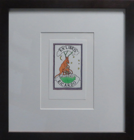
Artwork - bookplate, Geoffrey Ricardo, Ex Libris Geoffrey Ricardo, not dated
GEOFFREY RICARDO (1964- ) Born Melbourne, Australia 1984-86 Bachelor of Arts (Fine Art), Printmaking, Chisholm Institute of Technology, Melbourne 1987-89 Printing Assistant at Bill Young Studios, Editioning intaglio prints, King Valley, VIC 1988 Full-time Studio Technician at Printmaking Department, Chisholm Institute of Technology, Melbourne 1989-90 Graduate Diploma (Fine Art), Printmaking, Monash University, Melbourne 1991 Traveled to England, France, Spain and USA (Winsor & Newton International Travelling Bursary, National Students Art Prize) Worked in private studios in Gaucin, Spain and New York, USA 1994-95 Master of Fine Arts, Monash University, Melbourne 1995 Guest Lecturer, Victorian College of the Arts, Melbourne Traveled to Europe and America 1996 Guest Lecturer, Royal Melbourne Institute of Technology, Melbourne 1990-98 Sessional Lecturer, Monash University, Melbourne 1998 Traveled to America and Mexico 2001-05 Sessional Lecturer, The Victorian College of the Arts, Melbourne 2003-10 Printmaking Workshops, Warrnambool TAFE, Warrnambool, VIC 2004 Traveled to Europe, Mexico and Cuba 2005 Lecturer, National Art School (Summer School), Sydney Sessional Lecturer, Monash University, Melbourne Lecturer, Institution of Koorie Education, Deakin University, Geelong, VIC SOLO EXHIBITIONS 2012 ‘Collection of Works’ The Art Vault Mildura ‘Deeper Meanings’, The Incinerator Gallery, Melbourne ‘Three Projects’, Australian Galleries, Glenmore Road, Sydney Melbourne Art Fair Stand F33, Australian Galleries, Melbourne 2009 ‘Anno Domino, Antarctica and The Anatomy Lesson’, Australian Galleries Derby Street, Melbourne The Art Vault, Mildura, VIC 2008 MV Orlova (Quark Expeditions), The Drake Passage, Antarctica 2007 ‘Herd’, BMGArt, Adelaide ‘Herd’, Australian Galleries Painting & Sculpture, Sydney 2006 ‘Herd’, Australian Galleries Painting & Sculpture, Melbourne 2004 ‘Recent work’, BMGArt, Adelaide 2003 ‘The Rapunzel Suite and Other New Works’, Australian Galleries Works on Paper, Sydney ‘Recent Works’, Australian Galleries Painting & Sculpture, Melbourne ‘Recent works’, Cowwarr Art Space, Cowwarr, VIC 2002 ‘The Rapunzel Suite’, Australian Galleries Works on Paper, Melbourne ‘Strange Games’, Australian Galleries Works on Paper, Sydney 1999 ‘A Dark City Narrative’, Australian Galleries Works on Paper, Sydney ‘A Dark City Narrative’, Australian Galleries Works on Paper, Melbourne 1998 Cullity Gallery, School of Architecture and Fine Art, University of Western Australia, Perth 1997 Delaney Gallery, Perth Chapman Gallery, Canberra BMGArt, Adelaide ‘Menagerie’, Australian Galleries, Sydney ‘Menagerie’, Australian Galleries, Melbourne 1995 ‘Paintings, Prints and Sculpture’, Australian Galleries, Sydney ‘Prints, Paintings and Sculpture’, Australian Galleries, Melbourne 1994 Lawrence Wilson Art Gallery, University of Western Australia, Perth Graham Galleries + Editions, Brisbane ‘Wishful Thinking, Prints and Sculptures’, Lawrence Wilson Art Gallery, University of Western Australia, Perth 1992 ‘Prints, Sculptures and Watercolours’, Australian Galleries, Melbourne and Sydney 1990 ‘Watercolours, Prints and Small Bronzes’, Australian Galleries, Sydney ‘Paintings, Prints and Sculptures’, Australian Galleries, Melbourne GROUP EXHIBITIONS 2013 ‘Sculpture by the Sea’ Cottlesloe, Western Australia 2012 ‘Brave New World’, Toyota Community Spirit Gallery, Port Melbourne, VIC ‘Sculpture by the Sea’, Bondi, Sydney 2011 ‘Sculpture by the sea’, Aarhus, Denmark ‘Artwork to Tapestry’, Tarrawarra Museum of Art, Healesville, VIC Burnie Print Prize, Burnie Regional Gallery, Burnie, TAS ‘large exhibition of small works’, Australian Galleries, Roylston Street, Sydney ‘large exhibition of small works’, Australian Galleries, Derby Street, Melbourne ‘Nature of the Mark’, Australian Galleries, Smith Street, Melbourne Rick Amor Print Prize, Montsalvat, Eltham, VIC 2010 ‘Summer show’, Australian Galleries, Glenmore Road, Sydney ‘Summer stock show’, Australian Galleries, Smith Street, Melbourne ‘Sub10’, Substation, Melbourne ‘McClelland Sculpture Survey and Award 2010’, McClelland Gallery + Sculpture Park, Langwarrin, VIC ‘Artists’ Prints made with Integrity I’, Australian Galleries, Smith Street, Melbourne Montalto Sculpture Prize, Montalto Vineyard and Olive Grove, Red Hill South, VIC 2009 ‘Artists’ ink: printmaking from the Warrnambool Art Gallery Collection, 1970-2001’, Ararat Regional Art Gallery, Ararat, VIC ‘Lorne Sculpture’ (Winner), Lorne, VIC 2008 ‘Summer Stock Show’, Australian Galleries Smith Street, Melbourne 2007 ARC Biennial (Art, Design and Craft), Queensland University of Technology Art Museum, Brisbane ‘Prints Tokyo: International Print Exhibition’, Tokyo, Japan Seoul International Print, Photo and Edition Works Art Fair, Seoul, Korea Guanlan International Print Biennial, Guanlan, China ‘Summer Stock Show’, Australian Galleries Works on Paper, Sydney ‘Summer Stock Show’, Australian Galleries Painting & Sculpture, Melbourne ‘Summer Stock Show’, Australian Galleries Works on Paper, Melbourne ‘Antipodean Bestiary’, Project Space / Spare Room, RMIT University, Melbourne Montalto Sculpture Prize, Montalto Vineyard and Olive Grove, Red Hill South, VIC McClelland Sculpture Survey and Award 2007, McClelland Gallery + Sculpture Park, Langwarrin, VIC ‘2007: Works from the studio’, Lancaster Press, Melbourne ‘50 - a print exchange portfolio’, Geelong Art Gallery, Geelong, VIC ‘Small Pleasures’, Australian Galleries Painting & Sculpture, Melbourne ‘Stock Show’, Australian Galleries Painting & Sculpture, Melbourne ‘Artists for Kids Culture’, Brightspace, Melbourne 2006 ‘Partnership or perish’, Academy of the Arts, School of Visual and Performing Arts, University of Tasmania, Hobart Libris Awards, Artspace Mackay, Mackay, QLD ‘Summery’, Australian Galleries Painting & Sculpture, Sydney ‘Summer Stock Show’, Australian Galleries Works on Paper, Melbourne ‘Bookish’, Australian Galleries Works on Paper, Melbourne Melbourne Art Fair, Australian Galleries, Melbourne ‘Artists for Kids Culture’, Brightspace, Melbourne ‘50th Anniversary Exhibition’, Australian Galleries Painting & Sculpture, Melbourne 2005 ‘End of Year Group Exhibition’, Australian Galleries Painting & Sculpture, Sydney ‘Contemporary Works on Paper’, Australian Galleries Works on Paper, Melbourne ‘Expansion’, Lancaster Press, Melbourne ‘The Art of Collaboration’, Singapore Tyler Print Institute, Singapore ‘Double take’, Arts Project Australia, Melbourne ‘Small Treasures - 20 emerging and established artists’, TILT Contemporary Art, Melbourne Jacques Cadry Memorial Art Prize, Fox Studios and State Library of NSW, Sydney ‘Tales of the City’, Australian Galleries Painting & Sculpture, Melbourne ‘A Decade of Collecting 1995-2005’, Cairns Regional Gallery, Cairns, QLD ‘Artists for Kids Culture’, Brightspace, Melbourne ‘Surface Tension: 21 Contemporary Australian Printmakers’, University of Tasmania, Launceston, TAS ‘Neo-millenium’, Toyota Community Spirit Gallery, Melbourne 2004 ‘Artists for Kids Culture’, Brightspace, Melbourne ‘Group Exhibition’, Australian Galleries Painting & Sculpture, Melbourne ‘Species’, Australian Galleries Works on Paper, Melbourne ‘In the presence of creatures great and small’, Australian Galleries Works on Paper, Sydney ‘Tapestries from the Victorian Tapestry Workshop’, Australian Galleries, Melbourne ‘Sculpture’, Australian Galleries Painting & Sculpture, Sydney ‘Contemporary Australian Prints’, National Arts Club, New York, USA ‘Contemporary Australian Prints’, Gallery 101, Melbourne ‘Contemporary Australian Prints from the Collection’, Art Gallery of New South Wales, Sydney ‘Bridge’, Toyota Community Spirit Gallery, Melbourne ‘Vivid’, Fortyfive Downstairs, Melbourne Lake Gallery, Paynesville, VIC 2003 ‘Paper matters’, Lawrence Wilson Art Gallery, University of Western Australia, Perth ‘Artists for Kids Culture’, Brightspace, Melbourne ‘Less is more’, BMGArt, Adelaide ‘The ink’s on me: Bill Young master printmaker’, Wangaratta Exhibitions Gallery, Wangaratta, VIC ‘Fantastic and Visionary Art’, Touring: Global Arts Link, QLD; Ipswich Regional Gallery, QLD ; Orange Regional Gallery, NSW; Manning Regional Gallery, NSW; Parramatta Heritage Centre, Sydney; Ballarat Regional Gallery, VIC 2002 Shell Fremantle Print Award, Fremantle Arts Centre, Fremantle, WA ‘Artists for Kids Culture’, Brightspace, Melbourne 2001 Shell Fremantle Print Award, Fremantle Arts Centre, Fremantle, WA ‘Six Degrees of Collaboration’, RMIT Faculty of Art, Design and Communication Gallery, Melbourne ‘Reciprocal Moves’, Warrnambool Art Gallery, Warrnambool, VIC International Print Triennial, Kanagawa, Japan ‘Fantastic Art’, Orange Regional Gallery, Orange, NSW ‘Dancing Made a Man out of Me’, The Switchback Gallery, Monash University, Gippsland, VIC ‘Artists for Kids Culture’, Brightspace, Melbourne ‘Celebration’, Regional touring exhibition, VIC 2000-01 ‘Workings of the Mind: Melbourne Prints of the 1960s to the 1990s’, Touring: Grafton Regional Gallery, NSW; Toowoomba Regional Art Gallery, QLD; Nolan Gallery, Canberra; Bendigo Art Gallery, VIC; PercTucker Regional Gallery, QLD 2000 Shell Fremantle Print Award, Fremantle Arts Centre, Fremantle, WA The Hutchins Art Prize, Long Gallery, Hobart ‘Artists for Kids Culture’, Brightspace, Melbourne 1999 Shell Fremantle Print Award, Fremantle Arts Space, Fremantle, WA ‘We are Australian’, George Adams Gallery, Victorian Arts Centre, Melbourne Rena Ellen Jones Memorial Print Award, Warrnambool Art Gallery, Warrnambool, VIC ‘National Works on Paper’, Mornington Peninsula Gallery, Mornington, VIC ‘Artists for Kids Culture’, Brightspace, Melbourne ‘Pleasure’, Australian Galleries, Melbourne 1998-99 ‘Australian Prints’, Art Gallery of New South Wales, Sydney 1997 ‘KNOCK, KNOCK’, Australian Galleries, Melbourne ‘Woven Colour, The Art of Tapestry’, Dr Earl Lu Gallery, Singapore 1996 M.P.A.C. Print Award, Mornington Peninsula Arts Centre, Mornington, VIC Academy of Art & Culture, Calcutta, India ‘Synergy’, Touring: Lalit Kala Akademi, New Dehli, India; Jehangir Nicholson Gallery, Bombay, India; Birla, India ‘Contemporary Australian Tapestry’, Frederikshavn Kunstmuseum, Denmark; Australia House, London, UK 1995 ‘Interweave - Tapestry A Collaborative Art’, Heide Museum of Modern Art, Melbourne ‘Contemporary Printmakers’, La Trobe Regional Gallery, Morwell, VIC ‘Contemporary Australian Tapestry’, Australian High Commission, Singapore ‘Circus Capers’, Caulfield Arts Complex, Melbourne 1994 M.P.A.C. Print Award, Mornington Peninsula Arts Centre, Mornington, VIC Fremantle Print Award, Fremantle Arts Centre, Fremantle, WA Australian Universities of Visual Art, Australian High Commission, Singapore ‘Prints, Paintings and Sculpture’, BMGArt, Adelaide Fourth Australian Contemporary Art Fair, Royal Exhibition Building, Melbourne 1993 Fremantle Print Award, Fremantle Arts Centre, Fremantle, WA 1992 Fremantle Print Award, Fremantle Arts Centre, Fremantle, WA ‘Transitional Times’, Print Council of Australia, Melbourne ‘Second Kochi International Triennial Exhibition of Prints’, Japan 1991 Henry Worland Memorial Print Prize, Warrnambool Regional Art Gallery, Warrnambool, VIC Fremantle Print Award, Fremantle Arts Centre, Fremantle, WA ‘Table Top Sculpture’, Australian Galleries, Melbourne ‘Art 91’, London Contemporary Art Fair, London, UK 1990 M.P.A.C. Print Prize, Mornington Peninsula Arts Centre, Mornington, VIC Fremantle Print Prize, Fremantle Arts Centre, Fremantle WA ‘The Christmas Show’, Intaglio Printmaker, London, England ‘Australian Contemporary Art’, AZ Gallery, Tokyo, Japan 1989 National Student Art Prize, Mitchell College, Bathurst, NSW Fremantle Print Award, Fremantle Arts Centre, Fremantle, WA City of Doncaster Acquisitive Print Prize, Manningham Gallery, Melbourne ‘Affiliations’, Monash University Gallery, Melbourne 1988 M.P.A.C. Acquisitive Print Prize, Mornington Peninsula Arts Centre, Mornington, VIC Henry Worland Memorial Print Prize, Warrnambool Regional Art Gallery, Warrnambool, VIC 1987 ‘The Comedy Show’, Print Guild, Melbourne ‘Fluxus Art Flow’, Melbourne 1986 Mornington Peninsula Arts Council Acquisitive Print Prize, Mornington Peninsula, VIC Chisolm Institute of Technology, Graduating Students exhibition, Melbourne AWARDS 2013 King Valley Art Prize (printmaking) 2009 Lorne Sculpture Exhibition (Winner), Lorne, VIC 1989 Windsor and Newton International Travelling Bursary, UK Linbrook International First Prize for Printmaking, Australia COMMISSIONS 2005 Tapestry design for Bairnsdale Hospital (woven by the Victorian Tapestry Workshop, Melbourne), Bairnsdale, VIC 1999 Tapestry design ‘Emblem’ (woven by the Victorian Tapestry Workshop, Melbourne), Australia 1995 ‘A Night of Infectious Laughter’ Poster, St Kilda Festival, Melbourne 1994 Tapestry design ‘Elephant Gingham’ (woven by the Victorian Tapestry Workshop, Melbourne), Australia 1993 Tapestry design for the Festival of Perth Official Poster (woven by the Victorian Tapestry Workshop, Melbourne), Perth RESIDENCIES & PROJECTS 2013 ‘Come In Outside’, Collaboration set design for Pocketfool 2011 Mildura Wentworth Arts Festival Project, Mildura, VIC Residency, The Art Vault , Mildura, VIC 2010 ‘Wish’, Collaboration set design for Pocketfool, Artplay, Melbourne The Art Vault (included continuous public flag making workshops which were flown as part of The Wentworth Mildura Art Festival), Mildura, VIC 2009 The Art Vault (included two public printmaking workshops), Mildura, VIC 2008 Artist in residence, MV Orlova, Quark Expeditions, Antarctica 2003 Residency, Bairnsdale Regional Health Service, Bairnsdale, VIC 1998 Residency, School of Architecture & Fine Art, University of Western Australia, Perth 1997 Residency, La Salle/Fia, College of the Arts, Singapore 1996 Artist in residence, Victorian Tapestry Workshop, Melbourne 1993 Reduction Aquatint Workshop & Residency, Graphic Investigation Department, Canberra School of Art, Canberra NB: all residencies have included workshops involving students, children or the general public COLLECTIONS Artbank, Sydney Art Gallery of New South Wales, Sydney Canson Australia Pty Ltd, Australia City of Box Hill, Melbourne City of Whitehorse, Melbourne Downlands College, Toowoomba, QLD Geelong Grammar School, Geelong, VIC Gold Coast City Art Gallery, Gold Coast, QLD Griffith University, Gold Coast, QLD Helensvale High School, Brisbane Holmes à Court Collection, Perth Latrobe Regional Gallery, Morwell, VIC Monash University, Melbourne Mornington Peninsula Arts Council Collection, Mornington, VIC National Gallery of Australia, Canberra National Gallery of Victoria, Melbourne Parliament House Art Collection, Canberra Print Council of Australia, Melbourne Private collections in Australia, Switzerland, USA, UK, Singapore, Germany, Japan, Malaysia, Holland Queen Victoria Museum & Art Gallery, Launceston, TAS Queensland Art Gallery, Brisbane Queensland University of Technology, Brisbane Shire of Diamond Valley, Diamond Valley, VIC Star of the Sea College, Melbourne The Melbourne Club, Melbourne University of Central Queensland, Brisbane University of Technology, Sydney Wagga Wagga Regional Art Gallery, Wagga Wagga, NSW Warrnambool Regional Art Gallery, Warrnambool, VIC BIBLIOGRAPHY PERIODICALS AQ Journal of Contemporary Analysis, Vol. 70, Issue 4, July-August 1998 AQ Journal of Contemporary Analysis, Vol. 70, Issue 6, November-December 1998 AQ Journal of Contemporary Analysis, Vol.71, Issue 7, April 1999 Backhouse, Megan; “Going out of print and back to basics”, The Age, February 2003 Bellamy, Louise; “Renaissance of Western Art”, The Age (A2 section), 26 November 2005 Clabburn, Anna; “Fables and Foibles”, Art Monthly, September 1994 Dutkiewicz, Adam; “Edge of the sublime”, Advertiser, 1 December 2003, p. 76. Erickson, Dorothy; “The Festival that could have been”, The Bulletin, March 1994 Farmer, Alison; “Ricardo makes poster splash”, Sunday Times - Entertainment Extra, 19 September 1993 “Festival taps weaver’s art”, The West Australian, 11February 1994 Fiasco (web-page), March 2003 Jenkins, John; “A Dark City Narrative”, Imprint, Vol. 34, No. 4, 1999 Grishin, Sasha; “Multiplicity – collecting Australian prints”, Australian Art Review, Issue 13, March-June 2007, pp. 52-55 Grishin, Sasha; “Profiles in Print - Geoffrey Ricardo”, Craft Arts International, Issue 76, 2009, pp.1-4 Lloyd, Tim; “The elephant man”, The Advertiser (Review section), December 2007 Manzana Arné, Josep; “De L’Ex-Libris a L’Ex-Webis: Ex-Libris a Internet”, Ex-Libris, Associació Catalana D’Exlibristes, Barcelona, No. 27, July-December 2002, p.11 McDonald, John; “Dreams of hope and menace” The Sydney Morning Herald, 18 March 1995 McMillan, Peter; “Darkness visible”, The Age, 11September 1999 Nelson, Robert; “Circuses can be curated, but not cured”, The Age, 18 January 1995 Nelson, Robert; “Dream Weavers”, The Age, June 1995 Nelson, Robert; “Paen To Ricardo”, Imprint, Vol. 29, No.1, April, 1994 Nelson, Robert; “Revealed: Mother Nature’s vulgar past”, The Age, September 6, 2000 Nelson, Robert; “Riddled with hidden meaning”, The Age, September 8, 1999 Quadrant, April, 1995 Quadrant, Jan/Feb, 1995 Quadrant, October, 1995 Quadrant, November, 1994 “Ricardo’s surreal works at gallery”, Times-Spectator, 25 July 2003, p.7 Snell, Ted; “Art”, The Australian, 18 February1994 Snell, Ted; “Visual arts at the Festival of Perth”, Art Monthly, April 1994 Sunday Arts, ABC TV, 6 May 2007 Timms, Peter; “Geoff Ricardo: emerging from darkness”, Art Monthly, Issue 140, June 2001 Wallace, Dr Carmel; “Ways of seeing Australia”, Asian Art News, May/June 2004 BOOKS & CATALOGUES A Dark City Narrative, Australian Galleries, Melbourne, 1999 ARC Biennial Exhibition (Exhibition catalogue), Queensland University of Technology Art Museum, 2007, pp. 78-79 Clabburn, Anna; “The Collaborative Spirit”, Australian Tapestries: Victorian Tapestry Workshop, 1995, p. 37 Fantastic Art, Orange Regional Gallery, NSW, 2001 Field, Caroline; Herd, catalogue essay, Australian Galleries, Sydney, 2007 Grishin, Sasha; Australian Identities in Printmaking, Wagga Wagga Regional Art Gallery, 2000 Grishin, Sasha; Australian Printmaking in the 1990’s, Craftsman House, 1997 Havighurst, Sophie (Illustrations by Geoffrey Ricardo); When Lester lost his cool, The University of Melbourne, 2007 Kolenberg, Hendrik & Ryan, Anne; Australian Prints, Art Gallery of New South Wales, 1998 Lawrence, Michel; Framed; photographs of Australian Artists, 1998 Modern Australian Tapestries, Victorian Tapestry Workshop, 2000 The Rapunzel Suite, Australian Galleries, Melbourne, 2002 Wallace, Dr Carmel (Essay); Surface Tension, Twenty One Contemporary Australian Printmakers, Gallery 101, Melbourne, 2004 Workings of the Mind : Melbourne Prints of the 1960s to the 1990s, Queensland University of Technology Art Museum, Brisbane, 2000 TELEVISION Sunday Arts, ABC TV, 6 May 2007 Inside Art TV, Channel 31, July 2012Framed bookplategeoffrey ricardo, bookplates, kangaroo -
 Federation University Art Collection
Work on paper - Artwork - Printmaking, Geoffrey Ricardo, 'Monkeyshine' by Geoffrey Ricardo, 2000
GEOFFREY RICARDO (1964- ) Born Melbourne, Australia 1984-86 Bachelor of Arts (Fine Art), Printmaking, Chisholm Institute of Technology, Melbourne 1987-89 Printing Assistant at Bill Young Studios, Editioning intaglio prints, King Valley, VIC 1988 Full-time Studio Technician at Printmaking Department, Chisholm Institute of Technology, Melbourne 1989-90 Graduate Diploma (Fine Art), Printmaking, Monash University, Melbourne 1991 Traveled to England, France, Spain and USA (Winsor & Newton International Travelling Bursary, National Students Art Prize) Worked in private studios in Gaucin, Spain and New York, USA 1994-95 Master of Fine Arts, Monash University, Melbourne 1995 Guest Lecturer, Victorian College of the Arts, Melbourne Traveled to Europe and America 1996 Guest Lecturer, Royal Melbourne Institute of Technology, Melbourne 1990-98 Sessional Lecturer, Monash University, Melbourne 1998 Traveled to America and Mexico 2001-05 Sessional Lecturer, The Victorian College of the Arts, Melbourne 2003-10 Printmaking Workshops, Warrnambool TAFE, Warrnambool, VIC 2004 Traveled to Europe, Mexico and Cuba 2005 Lecturer, National Art School (Summer School), Sydney Sessional Lecturer, Monash University, Melbourne Lecturer, Institution of Koorie Education, Deakin University, Geelong, VIC SOLO EXHIBITIONS 2012 ‘Collection of Works’ The Art Vault Mildura ‘Deeper Meanings’, The Incinerator Gallery, Melbourne ‘Three Projects’, Australian Galleries, Glenmore Road, Sydney Melbourne Art Fair Stand F33, Australian Galleries, Melbourne 2009 ‘Anno Domino, Antarctica and The Anatomy Lesson’, Australian Galleries Derby Street, Melbourne The Art Vault, Mildura, VIC 2008 MV Orlova (Quark Expeditions), The Drake Passage, Antarctica 2007 ‘Herd’, BMGArt, Adelaide ‘Herd’, Australian Galleries Painting & Sculpture, Sydney 2006 ‘Herd’, Australian Galleries Painting & Sculpture, Melbourne 2004 ‘Recent work’, BMGArt, Adelaide 2003 ‘The Rapunzel Suite and Other New Works’, Australian Galleries Works on Paper, Sydney ‘Recent Works’, Australian Galleries Painting & Sculpture, Melbourne ‘Recent works’, Cowwarr Art Space, Cowwarr, VIC 2002 ‘The Rapunzel Suite’, Australian Galleries Works on Paper, Melbourne ‘Strange Games’, Australian Galleries Works on Paper, Sydney 1999 ‘A Dark City Narrative’, Australian Galleries Works on Paper, Sydney ‘A Dark City Narrative’, Australian Galleries Works on Paper, Melbourne 1998 Cullity Gallery, School of Architecture and Fine Art, University of Western Australia, Perth 1997 Delaney Gallery, Perth Chapman Gallery, Canberra BMGArt, Adelaide ‘Menagerie’, Australian Galleries, Sydney ‘Menagerie’, Australian Galleries, Melbourne 1995 ‘Paintings, Prints and Sculpture’, Australian Galleries, Sydney ‘Prints, Paintings and Sculpture’, Australian Galleries, Melbourne 1994 Lawrence Wilson Art Gallery, University of Western Australia, Perth Graham Galleries + Editions, Brisbane ‘Wishful Thinking, Prints and Sculptures’, Lawrence Wilson Art Gallery, University of Western Australia, Perth 1992 ‘Prints, Sculptures and Watercolours’, Australian Galleries, Melbourne and Sydney 1990 ‘Watercolours, Prints and Small Bronzes’, Australian Galleries, Sydney ‘Paintings, Prints and Sculptures’, Australian Galleries, Melbourne GROUP EXHIBITIONS 2013 ‘Sculpture by the Sea’ Cottlesloe, Western Australia 2012 ‘Brave New World’, Toyota Community Spirit Gallery, Port Melbourne, VIC ‘Sculpture by the Sea’, Bondi, Sydney 2011 ‘Sculpture by the sea’, Aarhus, Denmark ‘Artwork to Tapestry’, Tarrawarra Museum of Art, Healesville, VIC Burnie Print Prize, Burnie Regional Gallery, Burnie, TAS ‘large exhibition of small works’, Australian Galleries, Roylston Street, Sydney ‘large exhibition of small works’, Australian Galleries, Derby Street, Melbourne ‘Nature of the Mark’, Australian Galleries, Smith Street, Melbourne Rick Amor Print Prize, Montsalvat, Eltham, VIC 2010 ‘Summer show’, Australian Galleries, Glenmore Road, Sydney ‘Summer stock show’, Australian Galleries, Smith Street, Melbourne ‘Sub10’, Substation, Melbourne ‘McClelland Sculpture Survey and Award 2010’, McClelland Gallery + Sculpture Park, Langwarrin, VIC ‘Artists’ Prints made with Integrity I’, Australian Galleries, Smith Street, Melbourne Montalto Sculpture Prize, Montalto Vineyard and Olive Grove, Red Hill South, VIC 2009 ‘Artists’ ink: printmaking from the Warrnambool Art Gallery Collection, 1970-2001’, Ararat Regional Art Gallery, Ararat, VIC ‘Lorne Sculpture’ (Winner), Lorne, VIC 2008 ‘Summer Stock Show’, Australian Galleries Smith Street, Melbourne 2007 ARC Biennial (Art, Design and Craft), Queensland University of Technology Art Museum, Brisbane ‘Prints Tokyo: International Print Exhibition’, Tokyo, Japan Seoul International Print, Photo and Edition Works Art Fair, Seoul, Korea Guanlan International Print Biennial, Guanlan, China ‘Summer Stock Show’, Australian Galleries Works on Paper, Sydney ‘Summer Stock Show’, Australian Galleries Painting & Sculpture, Melbourne ‘Summer Stock Show’, Australian Galleries Works on Paper, Melbourne ‘Antipodean Bestiary’, Project Space / Spare Room, RMIT University, Melbourne Montalto Sculpture Prize, Montalto Vineyard and Olive Grove, Red Hill South, VIC McClelland Sculpture Survey and Award 2007, McClelland Gallery + Sculpture Park, Langwarrin, VIC ‘2007: Works from the studio’, Lancaster Press, Melbourne ‘50 - a print exchange portfolio’, Geelong Art Gallery, Geelong, VIC ‘Small Pleasures’, Australian Galleries Painting & Sculpture, Melbourne ‘Stock Show’, Australian Galleries Painting & Sculpture, Melbourne ‘Artists for Kids Culture’, Brightspace, Melbourne 2006 ‘Partnership or perish’, Academy of the Arts, School of Visual and Performing Arts, University of Tasmania, Hobart Libris Awards, Artspace Mackay, Mackay, QLD ‘Summery’, Australian Galleries Painting & Sculpture, Sydney ‘Summer Stock Show’, Australian Galleries Works on Paper, Melbourne ‘Bookish’, Australian Galleries Works on Paper, Melbourne Melbourne Art Fair, Australian Galleries, Melbourne ‘Artists for Kids Culture’, Brightspace, Melbourne ‘50th Anniversary Exhibition’, Australian Galleries Painting & Sculpture, Melbourne 2005 ‘End of Year Group Exhibition’, Australian Galleries Painting & Sculpture, Sydney ‘Contemporary Works on Paper’, Australian Galleries Works on Paper, Melbourne ‘Expansion’, Lancaster Press, Melbourne ‘The Art of Collaboration’, Singapore Tyler Print Institute, Singapore ‘Double take’, Arts Project Australia, Melbourne ‘Small Treasures - 20 emerging and established artists’, TILT Contemporary Art, Melbourne Jacques Cadry Memorial Art Prize, Fox Studios and State Library of NSW, Sydney ‘Tales of the City’, Australian Galleries Painting & Sculpture, Melbourne ‘A Decade of Collecting 1995-2005’, Cairns Regional Gallery, Cairns, QLD ‘Artists for Kids Culture’, Brightspace, Melbourne ‘Surface Tension: 21 Contemporary Australian Printmakers’, University of Tasmania, Launceston, TAS ‘Neo-millenium’, Toyota Community Spirit Gallery, Melbourne 2004 ‘Artists for Kids Culture’, Brightspace, Melbourne ‘Group Exhibition’, Australian Galleries Painting & Sculpture, Melbourne ‘Species’, Australian Galleries Works on Paper, Melbourne ‘In the presence of creatures great and small’, Australian Galleries Works on Paper, Sydney ‘Tapestries from the Victorian Tapestry Workshop’, Australian Galleries, Melbourne ‘Sculpture’, Australian Galleries Painting & Sculpture, Sydney ‘Contemporary Australian Prints’, National Arts Club, New York, USA ‘Contemporary Australian Prints’, Gallery 101, Melbourne ‘Contemporary Australian Prints from the Collection’, Art Gallery of New South Wales, Sydney ‘Bridge’, Toyota Community Spirit Gallery, Melbourne ‘Vivid’, Fortyfive Downstairs, Melbourne Lake Gallery, Paynesville, VIC 2003 ‘Paper matters’, Lawrence Wilson Art Gallery, University of Western Australia, Perth ‘Artists for Kids Culture’, Brightspace, Melbourne ‘Less is more’, BMGArt, Adelaide ‘The ink’s on me: Bill Young master printmaker’, Wangaratta Exhibitions Gallery, Wangaratta, VIC ‘Fantastic and Visionary Art’, Touring: Global Arts Link, QLD; Ipswich Regional Gallery, QLD ; Orange Regional Gallery, NSW; Manning Regional Gallery, NSW; Parramatta Heritage Centre, Sydney; Ballarat Regional Gallery, VIC 2002 Shell Fremantle Print Award, Fremantle Arts Centre, Fremantle, WA ‘Artists for Kids Culture’, Brightspace, Melbourne 2001 Shell Fremantle Print Award, Fremantle Arts Centre, Fremantle, WA ‘Six Degrees of Collaboration’, RMIT Faculty of Art, Design and Communication Gallery, Melbourne ‘Reciprocal Moves’, Warrnambool Art Gallery, Warrnambool, VIC International Print Triennial, Kanagawa, Japan ‘Fantastic Art’, Orange Regional Gallery, Orange, NSW ‘Dancing Made a Man out of Me’, The Switchback Gallery, Monash University, Gippsland, VIC ‘Artists for Kids Culture’, Brightspace, Melbourne ‘Celebration’, Regional touring exhibition, VIC 2000-01 ‘Workings of the Mind: Melbourne Prints of the 1960s to the 1990s’, Touring: Grafton Regional Gallery, NSW; Toowoomba Regional Art Gallery, QLD; Nolan Gallery, Canberra; Bendigo Art Gallery, VIC; PercTucker Regional Gallery, QLD 2000 Shell Fremantle Print Award, Fremantle Arts Centre, Fremantle, WA The Hutchins Art Prize, Long Gallery, Hobart ‘Artists for Kids Culture’, Brightspace, Melbourne 1999 Shell Fremantle Print Award, Fremantle Arts Space, Fremantle, WA ‘We are Australian’, George Adams Gallery, Victorian Arts Centre, Melbourne Rena Ellen Jones Memorial Print Award, Warrnambool Art Gallery, Warrnambool, VIC ‘National Works on Paper’, Mornington Peninsula Gallery, Mornington, VIC ‘Artists for Kids Culture’, Brightspace, Melbourne ‘Pleasure’, Australian Galleries, Melbourne 1998-99 ‘Australian Prints’, Art Gallery of New South Wales, Sydney 1997 ‘KNOCK, KNOCK’, Australian Galleries, Melbourne ‘Woven Colour, The Art of Tapestry’, Dr Earl Lu Gallery, Singapore 1996 M.P.A.C. Print Award, Mornington Peninsula Arts Centre, Mornington, VIC Academy of Art & Culture, Calcutta, India ‘Synergy’, Touring: Lalit Kala Akademi, New Dehli, India; Jehangir Nicholson Gallery, Bombay, India; Birla, India ‘Contemporary Australian Tapestry’, Frederikshavn Kunstmuseum, Denmark; Australia House, London, UK 1995 ‘Interweave - Tapestry A Collaborative Art’, Heide Museum of Modern Art, Melbourne ‘Contemporary Printmakers’, La Trobe Regional Gallery, Morwell, VIC ‘Contemporary Australian Tapestry’, Australian High Commission, Singapore ‘Circus Capers’, Caulfield Arts Complex, Melbourne 1994 M.P.A.C. Print Award, Mornington Peninsula Arts Centre, Mornington, VIC Fremantle Print Award, Fremantle Arts Centre, Fremantle, WA Australian Universities of Visual Art, Australian High Commission, Singapore ‘Prints, Paintings and Sculpture’, BMGArt, Adelaide Fourth Australian Contemporary Art Fair, Royal Exhibition Building, Melbourne 1993 Fremantle Print Award, Fremantle Arts Centre, Fremantle, WA 1992 Fremantle Print Award, Fremantle Arts Centre, Fremantle, WA ‘Transitional Times’, Print Council of Australia, Melbourne ‘Second Kochi International Triennial Exhibition of Prints’, Japan 1991 Henry Worland Memorial Print Prize, Warrnambool Regional Art Gallery, Warrnambool, VIC Fremantle Print Award, Fremantle Arts Centre, Fremantle, WA ‘Table Top Sculpture’, Australian Galleries, Melbourne ‘Art 91’, London Contemporary Art Fair, London, UK 1990 M.P.A.C. Print Prize, Mornington Peninsula Arts Centre, Mornington, VIC Fremantle Print Prize, Fremantle Arts Centre, Fremantle WA ‘The Christmas Show’, Intaglio Printmaker, London, England ‘Australian Contemporary Art’, AZ Gallery, Tokyo, Japan 1989 National Student Art Prize, Mitchell College, Bathurst, NSW Fremantle Print Award, Fremantle Arts Centre, Fremantle, WA City of Doncaster Acquisitive Print Prize, Manningham Gallery, Melbourne ‘Affiliations’, Monash University Gallery, Melbourne 1988 M.P.A.C. Acquisitive Print Prize, Mornington Peninsula Arts Centre, Mornington, VIC Henry Worland Memorial Print Prize, Warrnambool Regional Art Gallery, Warrnambool, VIC 1987 ‘The Comedy Show’, Print Guild, Melbourne ‘Fluxus Art Flow’, Melbourne 1986 Mornington Peninsula Arts Council Acquisitive Print Prize, Mornington Peninsula, VIC Chisolm Institute of Technology, Graduating Students exhibition, Melbourne AWARDS 2013 King Valley Art Prize (printmaking) 2009 Lorne Sculpture Exhibition (Winner), Lorne, VIC 1989 Windsor and Newton International Travelling Bursary, UK Linbrook International First Prize for Printmaking, Australia COMMISSIONS 2005 Tapestry design for Bairnsdale Hospital (woven by the Victorian Tapestry Workshop, Melbourne), Bairnsdale, VIC 1999 Tapestry design ‘Emblem’ (woven by the Victorian Tapestry Workshop, Melbourne), Australia 1995 ‘A Night of Infectious Laughter’ Poster, St Kilda Festival, Melbourne 1994 Tapestry design ‘Elephant Gingham’ (woven by the Victorian Tapestry Workshop, Melbourne), Australia 1993 Tapestry design for the Festival of Perth Official Poster (woven by the Victorian Tapestry Workshop, Melbourne), Perth RESIDENCIES & PROJECTS 2013 ‘Come In Outside’, Collaboration set design for Pocketfool 2011 Mildura Wentworth Arts Festival Project, Mildura, VIC Residency, The Art Vault , Mildura, VIC 2010 ‘Wish’, Collaboration set design for Pocketfool, Artplay, Melbourne The Art Vault (included continuous public flag making workshops which were flown as part of The Wentworth Mildura Art Festival), Mildura, VIC 2009 The Art Vault (included two public printmaking workshops), Mildura, VIC 2008 Artist in residence, MV Orlova, Quark Expeditions, Antarctica 2003 Residency, Bairnsdale Regional Health Service, Bairnsdale, VIC 1998 Residency, School of Architecture & Fine Art, University of Western Australia, Perth 1997 Residency, La Salle/Fia, College of the Arts, Singapore 1996 Artist in residence, Victorian Tapestry Workshop, Melbourne 1993 Reduction Aquatint Workshop & Residency, Graphic Investigation Department, Canberra School of Art, Canberra NB: all residencies have included workshops involving students, children or the general public COLLECTIONS Artbank, Sydney Art Gallery of New South Wales, Sydney Canson Australia Pty Ltd, Australia City of Box Hill, Melbourne City of Whitehorse, Melbourne Downlands College, Toowoomba, QLD Geelong Grammar School, Geelong, VIC Gold Coast City Art Gallery, Gold Coast, QLD Griffith University, Gold Coast, QLD Helensvale High School, Brisbane Holmes à Court Collection, Perth Latrobe Regional Gallery, Morwell, VIC Monash University, Melbourne Mornington Peninsula Arts Council Collection, Mornington, VIC National Gallery of Australia, Canberra National Gallery of Victoria, Melbourne Parliament House Art Collection, Canberra Print Council of Australia, Melbourne Private collections in Australia, Switzerland, USA, UK, Singapore, Germany, Japan, Malaysia, Holland Queen Victoria Museum & Art Gallery, Launceston, TAS Queensland Art Gallery, Brisbane Queensland University of Technology, Brisbane Shire of Diamond Valley, Diamond Valley, VIC Star of the Sea College, Melbourne The Melbourne Club, Melbourne University of Central Queensland, Brisbane University of Technology, Sydney Wagga Wagga Regional Art Gallery, Wagga Wagga, NSW Warrnambool Regional Art Gallery, Warrnambool, VIC BIBLIOGRAPHY PERIODICALS AQ Journal of Contemporary Analysis, Vol. 70, Issue 4, July-August 1998 AQ Journal of Contemporary Analysis, Vol. 70, Issue 6, November-December 1998 AQ Journal of Contemporary Analysis, Vol.71, Issue 7, April 1999 Backhouse, Megan; “Going out of print and back to basics”, The Age, February 2003 Bellamy, Louise; “Renaissance of Western Art”, The Age (A2 section), 26 November 2005 Clabburn, Anna; “Fables and Foibles”, Art Monthly, September 1994 Dutkiewicz, Adam; “Edge of the sublime”, Advertiser, 1 December 2003, p. 76. Erickson, Dorothy; “The Festival that could have been”, The Bulletin, March 1994 Farmer, Alison; “Ricardo makes poster splash”, Sunday Times - Entertainment Extra, 19 September 1993 “Festival taps weaver’s art”, The West Australian, 11February 1994 Fiasco (web-page), March 2003 Jenkins, John; “A Dark City Narrative”, Imprint, Vol. 34, No. 4, 1999 Grishin, Sasha; “Multiplicity – collecting Australian prints”, Australian Art Review, Issue 13, March-June 2007, pp. 52-55 Grishin, Sasha; “Profiles in Print - Geoffrey Ricardo”, Craft Arts International, Issue 76, 2009, pp.1-4 Lloyd, Tim; “The elephant man”, The Advertiser (Review section), December 2007 Manzana Arné, Josep; “De L’Ex-Libris a L’Ex-Webis: Ex-Libris a Internet”, Ex-Libris, Associació Catalana D’Exlibristes, Barcelona, No. 27, July-December 2002, p.11 McDonald, John; “Dreams of hope and menace” The Sydney Morning Herald, 18 March 1995 McMillan, Peter; “Darkness visible”, The Age, 11September 1999 Nelson, Robert; “Circuses can be curated, but not cured”, The Age, 18 January 1995 Nelson, Robert; “Dream Weavers”, The Age, June 1995 Nelson, Robert; “Paen To Ricardo”, Imprint, Vol. 29, No.1, April, 1994 Nelson, Robert; “Revealed: Mother Nature’s vulgar past”, The Age, September 6, 2000 Nelson, Robert; “Riddled with hidden meaning”, The Age, September 8, 1999 Quadrant, April, 1995 Quadrant, Jan/Feb, 1995 Quadrant, October, 1995 Quadrant, November, 1994 “Ricardo’s surreal works at gallery”, Times-Spectator, 25 July 2003, p.7 Snell, Ted; “Art”, The Australian, 18 February1994 Snell, Ted; “Visual arts at the Festival of Perth”, Art Monthly, April 1994 Sunday Arts, ABC TV, 6 May 2007 Timms, Peter; “Geoff Ricardo: emerging from darkness”, Art Monthly, Issue 140, June 2001 Wallace, Dr Carmel; “Ways of seeing Australia”, Asian Art News, May/June 2004 BOOKS & CATALOGUES A Dark City Narrative, Australian Galleries, Melbourne, 1999 ARC Biennial Exhibition (Exhibition catalogue), Queensland University of Technology Art Museum, 2007, pp. 78-79 Clabburn, Anna; “The Collaborative Spirit”, Australian Tapestries: Victorian Tapestry Workshop, 1995, p. 37 Fantastic Art, Orange Regional Gallery, NSW, 2001 Field, Caroline; Herd, catalogue essay, Australian Galleries, Sydney, 2007 Grishin, Sasha; Australian Identities in Printmaking, Wagga Wagga Regional Art Gallery, 2000 Grishin, Sasha; Australian Printmaking in the 1990’s, Craftsman House, 1997 Havighurst, Sophie (Illustrations by Geoffrey Ricardo); When Lester lost his cool, The University of Melbourne, 2007 Kolenberg, Hendrik & Ryan, Anne; Australian Prints, Art Gallery of New South Wales, 1998 Lawrence, Michel; Framed; photographs of Australian Artists, 1998 Modern Australian Tapestries, Victorian Tapestry Workshop, 2000 The Rapunzel Suite, Australian Galleries, Melbourne, 2002 Wallace, Dr Carmel (Essay); Surface Tension, Twenty One Contemporary Australian Printmakers, Gallery 101, Melbourne, 2004 Workings of the Mind : Melbourne Prints of the 1960s to the 1990s, Queensland University of Technology Art Museum, Brisbane, 2000 TELEVISION Sunday Arts, ABC TV, 6 May 2007 Inside Art TV, Channel 31, July 2012Framed coloured aquatint on paper. Donated through the Australian Government's Cultural Gifts Programme by Katherine Littlewood.Under image in pencil ' T/P "Monkeyshine" Ricardo 2000'geoffrey ricardo, framed print -
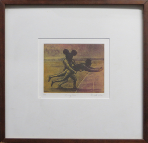 Federation University Art Collection
Work on paper - Artwork - Printmaking, Geoffrey Ricardo, 'Dummy Throw' by Geoffrey Ricardo, 2000
GEOFFREY RICARDO (1964- ) Born 1964, Melbourne, Australia 1984-86 Bachelor of Arts (Fine Art), Printmaking, Chisholm Institute of Technology, Melbourne 1987-89 Printing Assistant at Bill Young Studios, Editioning intaglio prints, King Valley, VIC 1988 Full-time Studio Technician at Printmaking Department, Chisholm Institute of Technology, Melbourne 1989-90 Graduate Diploma (Fine Art), Printmaking, Monash University, Melbourne 1991 Traveled to England, France, Spain and USA (Winsor & Newton International Travelling Bursary, National Students Art Prize) Worked in private studios in Gaucin, Spain and New York, USA 1994-95 Master of Fine Arts, Monash University, Melbourne 1995 Guest Lecturer, Victorian College of the Arts, Melbourne Traveled to Europe and America 1996 Guest Lecturer, Royal Melbourne Institute of Technology, Melbourne 1990-98 Sessional Lecturer, Monash University, Melbourne 1998 Traveled to America and Mexico 2001-05 Sessional Lecturer, The Victorian College of the Arts, Melbourne 2003-10 Printmaking Workshops, Warrnambool TAFE, Warrnambool, VIC 2004 Traveled to Europe, Mexico and Cuba 2005 Lecturer, National Art School (Summer School), Sydney Sessional Lecturer, Monash University, Melbourne Lecturer, Institution of Koorie Education, Deakin University, Geelong, VIC SOLO EXHIBITIONS 2012 ‘Collection of Works’ The Art Vault Mildura ‘Deeper Meanings’, The Incinerator Gallery, Melbourne ‘Three Projects’, Australian Galleries, Glenmore Road, Sydney Melbourne Art Fair Stand F33, Australian Galleries, Melbourne 2009 ‘Anno Domino, Antarctica and The Anatomy Lesson’, Australian Galleries Derby Street, Melbourne The Art Vault, Mildura, VIC 2008 MV Orlova (Quark Expeditions), The Drake Passage, Antarctica 2007 ‘Herd’, BMGArt, Adelaide ‘Herd’, Australian Galleries Painting & Sculpture, Sydney 2006 ‘Herd’, Australian Galleries Painting & Sculpture, Melbourne 2004 ‘Recent work’, BMGArt, Adelaide 2003 ‘The Rapunzel Suite and Other New Works’, Australian Galleries Works on Paper, Sydney ‘Recent Works’, Australian Galleries Painting & Sculpture, Melbourne ‘Recent works’, Cowwarr Art Space, Cowwarr, VIC 2002 ‘The Rapunzel Suite’, Australian Galleries Works on Paper, Melbourne ‘Strange Games’, Australian Galleries Works on Paper, Sydney 1999 ‘A Dark City Narrative’, Australian Galleries Works on Paper, Sydney ‘A Dark City Narrative’, Australian Galleries Works on Paper, Melbourne 1998 Cullity Gallery, School of Architecture and Fine Art, University of Western Australia, Perth 1997 Delaney Gallery, Perth Chapman Gallery, Canberra BMGArt, Adelaide ‘Menagerie’, Australian Galleries, Sydney ‘Menagerie’, Australian Galleries, Melbourne 1995 ‘Paintings, Prints and Sculpture’, Australian Galleries, Sydney ‘Prints, Paintings and Sculpture’, Australian Galleries, Melbourne 1994 Lawrence Wilson Art Gallery, University of Western Australia, Perth Graham Galleries + Editions, Brisbane ‘Wishful Thinking, Prints and Sculptures’, Lawrence Wilson Art Gallery, University of Western Australia, Perth 1992 ‘Prints, Sculptures and Watercolours’, Australian Galleries, Melbourne and Sydney 1990 ‘Watercolours, Prints and Small Bronzes’, Australian Galleries, Sydney ‘Paintings, Prints and Sculptures’, Australian Galleries, Melbourne GROUP EXHIBITIONS 2013 ‘Sculpture by the Sea’ Cottlesloe, Western Australia 2012 ‘Brave New World’, Toyota Community Spirit Gallery, Port Melbourne, VIC ‘Sculpture by the Sea’, Bondi, Sydney 2011 ‘Sculpture by the sea’, Aarhus, Denmark ‘Artwork to Tapestry’, Tarrawarra Museum of Art, Healesville, VIC Burnie Print Prize, Burnie Regional Gallery, Burnie, TAS ‘large exhibition of small works’, Australian Galleries, Roylston Street, Sydney ‘large exhibition of small works’, Australian Galleries, Derby Street, Melbourne ‘Nature of the Mark’, Australian Galleries, Smith Street, Melbourne Rick Amor Print Prize, Montsalvat, Eltham, VIC 2010 ‘Summer show’, Australian Galleries, Glenmore Road, Sydney ‘Summer stock show’, Australian Galleries, Smith Street, Melbourne ‘Sub10’, Substation, Melbourne ‘McClelland Sculpture Survey and Award 2010’, McClelland Gallery + Sculpture Park, Langwarrin, VIC ‘Artists’ Prints made with Integrity I’, Australian Galleries, Smith Street, Melbourne Montalto Sculpture Prize, Montalto Vineyard and Olive Grove, Red Hill South, VIC 2009 ‘Artists’ ink: printmaking from the Warrnambool Art Gallery Collection, 1970-2001’, Ararat Regional Art Gallery, Ararat, VIC ‘Lorne Sculpture’ (Winner), Lorne, VIC 2008 ‘Summer Stock Show’, Australian Galleries Smith Street, Melbourne 2007 ARC Biennial (Art, Design and Craft), Queensland University of Technology Art Museum, Brisbane ‘Prints Tokyo: International Print Exhibition’, Tokyo, Japan Seoul International Print, Photo and Edition Works Art Fair, Seoul, Korea Guanlan International Print Biennial, Guanlan, China ‘Summer Stock Show’, Australian Galleries Works on Paper, Sydney ‘Summer Stock Show’, Australian Galleries Painting & Sculpture, Melbourne ‘Summer Stock Show’, Australian Galleries Works on Paper, Melbourne ‘Antipodean Bestiary’, Project Space / Spare Room, RMIT University, Melbourne Montalto Sculpture Prize, Montalto Vineyard and Olive Grove, Red Hill South, VIC McClelland Sculpture Survey and Award 2007, McClelland Gallery + Sculpture Park, Langwarrin, VIC ‘2007: Works from the studio’, Lancaster Press, Melbourne ‘50 - a print exchange portfolio’, Geelong Art Gallery, Geelong, VIC ‘Small Pleasures’, Australian Galleries Painting & Sculpture, Melbourne ‘Stock Show’, Australian Galleries Painting & Sculpture, Melbourne ‘Artists for Kids Culture’, Brightspace, Melbourne 2006 ‘Partnership or perish’, Academy of the Arts, School of Visual and Performing Arts, University of Tasmania, Hobart Libris Awards, Artspace Mackay, Mackay, QLD ‘Summery’, Australian Galleries Painting & Sculpture, Sydney ‘Summer Stock Show’, Australian Galleries Works on Paper, Melbourne ‘Bookish’, Australian Galleries Works on Paper, Melbourne Melbourne Art Fair, Australian Galleries, Melbourne ‘Artists for Kids Culture’, Brightspace, Melbourne ‘50th Anniversary Exhibition’, Australian Galleries Painting & Sculpture, Melbourne 2005 ‘End of Year Group Exhibition’, Australian Galleries Painting & Sculpture, Sydney ‘Contemporary Works on Paper’, Australian Galleries Works on Paper, Melbourne ‘Expansion’, Lancaster Press, Melbourne ‘The Art of Collaboration’, Singapore Tyler Print Institute, Singapore ‘Double take’, Arts Project Australia, Melbourne ‘Small Treasures - 20 emerging and established artists’, TILT Contemporary Art, Melbourne Jacques Cadry Memorial Art Prize, Fox Studios and State Library of NSW, Sydney ‘Tales of the City’, Australian Galleries Painting & Sculpture, Melbourne ‘A Decade of Collecting 1995-2005’, Cairns Regional Gallery, Cairns, QLD ‘Artists for Kids Culture’, Brightspace, Melbourne ‘Surface Tension: 21 Contemporary Australian Printmakers’, University of Tasmania, Launceston, TAS ‘Neo-millenium’, Toyota Community Spirit Gallery, Melbourne 2004 ‘Artists for Kids Culture’, Brightspace, Melbourne ‘Group Exhibition’, Australian Galleries Painting & Sculpture, Melbourne ‘Species’, Australian Galleries Works on Paper, Melbourne ‘In the presence of creatures great and small’, Australian Galleries Works on Paper, Sydney ‘Tapestries from the Victorian Tapestry Workshop’, Australian Galleries, Melbourne ‘Sculpture’, Australian Galleries Painting & Sculpture, Sydney ‘Contemporary Australian Prints’, National Arts Club, New York, USA ‘Contemporary Australian Prints’, Gallery 101, Melbourne ‘Contemporary Australian Prints from the Collection’, Art Gallery of New South Wales, Sydney ‘Bridge’, Toyota Community Spirit Gallery, Melbourne ‘Vivid’, Fortyfive Downstairs, Melbourne Lake Gallery, Paynesville, VIC 2003 ‘Paper matters’, Lawrence Wilson Art Gallery, University of Western Australia, Perth ‘Artists for Kids Culture’, Brightspace, Melbourne ‘Less is more’, BMGArt, Adelaide ‘The ink’s on me: Bill Young master printmaker’, Wangaratta Exhibitions Gallery, Wangaratta, VIC ‘Fantastic and Visionary Art’, Touring: Global Arts Link, QLD; Ipswich Regional Gallery, QLD ; Orange Regional Gallery, NSW; Manning Regional Gallery, NSW; Parramatta Heritage Centre, Sydney; Ballarat Regional Gallery, VIC 2002 Shell Fremantle Print Award, Fremantle Arts Centre, Fremantle, WA ‘Artists for Kids Culture’, Brightspace, Melbourne 2001 Shell Fremantle Print Award, Fremantle Arts Centre, Fremantle, WA ‘Six Degrees of Collaboration’, RMIT Faculty of Art, Design and Communication Gallery, Melbourne ‘Reciprocal Moves’, Warrnambool Art Gallery, Warrnambool, VIC International Print Triennial, Kanagawa, Japan ‘Fantastic Art’, Orange Regional Gallery, Orange, NSW ‘Dancing Made a Man out of Me’, The Switchback Gallery, Monash University, Gippsland, VIC ‘Artists for Kids Culture’, Brightspace, Melbourne ‘Celebration’, Regional touring exhibition, VIC 2000-01 ‘Workings of the Mind: Melbourne Prints of the 1960s to the 1990s’, Touring: Grafton Regional Gallery, NSW; Toowoomba Regional Art Gallery, QLD; Nolan Gallery, Canberra; Bendigo Art Gallery, VIC; PercTucker Regional Gallery, QLD 2000 Shell Fremantle Print Award, Fremantle Arts Centre, Fremantle, WA The Hutchins Art Prize, Long Gallery, Hobart ‘Artists for Kids Culture’, Brightspace, Melbourne 1999 Shell Fremantle Print Award, Fremantle Arts Space, Fremantle, WA ‘We are Australian’, George Adams Gallery, Victorian Arts Centre, Melbourne Rena Ellen Jones Memorial Print Award, Warrnambool Art Gallery, Warrnambool, VIC ‘National Works on Paper’, Mornington Peninsula Gallery, Mornington, VIC ‘Artists for Kids Culture’, Brightspace, Melbourne ‘Pleasure’, Australian Galleries, Melbourne 1998-99 ‘Australian Prints’, Art Gallery of New South Wales, Sydney 1997 ‘KNOCK, KNOCK’, Australian Galleries, Melbourne ‘Woven Colour, The Art of Tapestry’, Dr Earl Lu Gallery, Singapore 1996 M.P.A.C. Print Award, Mornington Peninsula Arts Centre, Mornington, VIC Academy of Art & Culture, Calcutta, India ‘Synergy’, Touring: Lalit Kala Akademi, New Dehli, India; Jehangir Nicholson Gallery, Bombay, India; Birla, India ‘Contemporary Australian Tapestry’, Frederikshavn Kunstmuseum, Denmark; Australia House, London, UK 1995 ‘Interweave - Tapestry A Collaborative Art’, Heide Museum of Modern Art, Melbourne ‘Contemporary Printmakers’, La Trobe Regional Gallery, Morwell, VIC ‘Contemporary Australian Tapestry’, Australian High Commission, Singapore ‘Circus Capers’, Caulfield Arts Complex, Melbourne 1994 M.P.A.C. Print Award, Mornington Peninsula Arts Centre, Mornington, VIC Fremantle Print Award, Fremantle Arts Centre, Fremantle, WA Australian Universities of Visual Art, Australian High Commission, Singapore ‘Prints, Paintings and Sculpture’, BMGArt, Adelaide Fourth Australian Contemporary Art Fair, Royal Exhibition Building, Melbourne 1993 Fremantle Print Award, Fremantle Arts Centre, Fremantle, WA 1992 Fremantle Print Award, Fremantle Arts Centre, Fremantle, WA ‘Transitional Times’, Print Council of Australia, Melbourne ‘Second Kochi International Triennial Exhibition of Prints’, Japan 1991 Henry Worland Memorial Print Prize, Warrnambool Regional Art Gallery, Warrnambool, VIC Fremantle Print Award, Fremantle Arts Centre, Fremantle, WA ‘Table Top Sculpture’, Australian Galleries, Melbourne ‘Art 91’, London Contemporary Art Fair, London, UK 1990 M.P.A.C. Print Prize, Mornington Peninsula Arts Centre, Mornington, VIC Fremantle Print Prize, Fremantle Arts Centre, Fremantle WA ‘The Christmas Show’, Intaglio Printmaker, London, England ‘Australian Contemporary Art’, AZ Gallery, Tokyo, Japan 1989 National Student Art Prize, Mitchell College, Bathurst, NSW Fremantle Print Award, Fremantle Arts Centre, Fremantle, WA City of Doncaster Acquisitive Print Prize, Manningham Gallery, Melbourne ‘Affiliations’, Monash University Gallery, Melbourne 1988 M.P.A.C. Acquisitive Print Prize, Mornington Peninsula Arts Centre, Mornington, VIC Henry Worland Memorial Print Prize, Warrnambool Regional Art Gallery, Warrnambool, VIC 1987 ‘The Comedy Show’, Print Guild, Melbourne ‘Fluxus Art Flow’, Melbourne 1986 Mornington Peninsula Arts Council Acquisitive Print Prize, Mornington Peninsula, VIC Chisolm Institute of Technology, Graduating Students exhibition, Melbourne AWARDS 2013 King Valley Art Prize (printmaking) 2009 Lorne Sculpture Exhibition (Winner), Lorne, VIC 1989 Windsor and Newton International Travelling Bursary, UK Linbrook International First Prize for Printmaking, Australia COMMISSIONS 2005 Tapestry design for Bairnsdale Hospital (woven by the Victorian Tapestry Workshop, Melbourne), Bairnsdale, VIC 1999 Tapestry design ‘Emblem’ (woven by the Victorian Tapestry Workshop, Melbourne), Australia 1995 ‘A Night of Infectious Laughter’ Poster, St Kilda Festival, Melbourne 1994 Tapestry design ‘Elephant Gingham’ (woven by the Victorian Tapestry Workshop, Melbourne), Australia 1993 Tapestry design for the Festival of Perth Official Poster (woven by the Victorian Tapestry Workshop, Melbourne), Perth RESIDENCIES & PROJECTS 2013 ‘Come In Outside’, Collaboration set design for Pocketfool 2011 Mildura Wentworth Arts Festival Project, Mildura, VIC Residency, The Art Vault , Mildura, VIC 2010 ‘Wish’, Collaboration set design for Pocketfool, Artplay, Melbourne The Art Vault (included continuous public flag making workshops which were flown as part of The Wentworth Mildura Art Festival), Mildura, VIC 2009 The Art Vault (included two public printmaking workshops), Mildura, VIC 2008 Artist in residence, MV Orlova, Quark Expeditions, Antarctica 2003 Residency, Bairnsdale Regional Health Service, Bairnsdale, VIC 1998 Residency, School of Architecture & Fine Art, University of Western Australia, Perth 1997 Residency, La Salle/Fia, College of the Arts, Singapore 1996 Artist in residence, Victorian Tapestry Workshop, Melbourne 1993 Reduction Aquatint Workshop & Residency, Graphic Investigation Department, Canberra School of Art, Canberra NB: all residencies have included workshops involving students, children or the general public COLLECTIONS Artbank, Sydney Art Gallery of New South Wales, Sydney Canson Australia Pty Ltd, Australia City of Box Hill, Melbourne City of Whitehorse, Melbourne Downlands College, Toowoomba, QLD Geelong Grammar School, Geelong, VIC Gold Coast City Art Gallery, Gold Coast, QLD Griffith University, Gold Coast, QLD Helensvale High School, Brisbane Holmes à Court Collection, Perth Latrobe Regional Gallery, Morwell, VIC Monash University, Melbourne Mornington Peninsula Arts Council Collection, Mornington, VIC National Gallery of Australia, Canberra National Gallery of Victoria, Melbourne Parliament House Art Collection, Canberra Print Council of Australia, Melbourne Private collections in Australia, Switzerland, USA, UK, Singapore, Germany, Japan, Malaysia, Holland Queen Victoria Museum & Art Gallery, Launceston, TAS Queensland Art Gallery, Brisbane Queensland University of Technology, Brisbane Shire of Diamond Valley, Diamond Valley, VIC Star of the Sea College, Melbourne The Melbourne Club, Melbourne University of Central Queensland, Brisbane University of Technology, Sydney Wagga Wagga Regional Art Gallery, Wagga Wagga, NSW Warrnambool Regional Art Gallery, Warrnambool, VIC BIBLIOGRAPHY PERIODICALS AQ Journal of Contemporary Analysis, Vol. 70, Issue 4, July-August 1998 AQ Journal of Contemporary Analysis, Vol. 70, Issue 6, November-December 1998 AQ Journal of Contemporary Analysis, Vol.71, Issue 7, April 1999 Backhouse, Megan; “Going out of print and back to basics”, The Age, February 2003 Bellamy, Louise; “Renaissance of Western Art”, The Age (A2 section), 26 November 2005 Clabburn, Anna; “Fables and Foibles”, Art Monthly, September 1994 Dutkiewicz, Adam; “Edge of the sublime”, Advertiser, 1 December 2003, p. 76. Erickson, Dorothy; “The Festival that could have been”, The Bulletin, March 1994 Farmer, Alison; “Ricardo makes poster splash”, Sunday Times - Entertainment Extra, 19 September 1993 “Festival taps weaver’s art”, The West Australian, 11February 1994 Fiasco (web-page), March 2003 Jenkins, John; “A Dark City Narrative”, Imprint, Vol. 34, No. 4, 1999 Grishin, Sasha; “Multiplicity – collecting Australian prints”, Australian Art Review, Issue 13, March-June 2007, pp. 52-55 Grishin, Sasha; “Profiles in Print - Geoffrey Ricardo”, Craft Arts International, Issue 76, 2009, pp.1-4 Lloyd, Tim; “The elephant man”, The Advertiser (Review section), December 2007 Manzana Arné, Josep; “De L’Ex-Libris a L’Ex-Webis: Ex-Libris a Internet”, Ex-Libris, Associació Catalana D’Exlibristes, Barcelona, No. 27, July-December 2002, p.11 McDonald, John; “Dreams of hope and menace” The Sydney Morning Herald, 18 March 1995 McMillan, Peter; “Darkness visible”, The Age, 11September 1999 Nelson, Robert; “Circuses can be curated, but not cured”, The Age, 18 January 1995 Nelson, Robert; “Dream Weavers”, The Age, June 1995 Nelson, Robert; “Paen To Ricardo”, Imprint, Vol. 29, No.1, April, 1994 Nelson, Robert; “Revealed: Mother Nature’s vulgar past”, The Age, September 6, 2000 Nelson, Robert; “Riddled with hidden meaning”, The Age, September 8, 1999 Quadrant, April, 1995 Quadrant, Jan/Feb, 1995 Quadrant, October, 1995 Quadrant, November, 1994 “Ricardo’s surreal works at gallery”, Times-Spectator, 25 July 2003, p.7 Snell, Ted; “Art”, The Australian, 18 February1994 Snell, Ted; “Visual arts at the Festival of Perth”, Art Monthly, April 1994 Sunday Arts, ABC TV, 6 May 2007 Timms, Peter; “Geoff Ricardo: emerging from darkness”, Art Monthly, Issue 140, June 2001 Wallace, Dr Carmel; “Ways of seeing Australia”, Asian Art News, May/June 2004 BOOKS & CATALOGUES A Dark City Narrative, Australian Galleries, Melbourne, 1999 ARC Biennial Exhibition (Exhibition catalogue), Queensland University of Technology Art Museum, 2007, pp. 78-79 Clabburn, Anna; “The Collaborative Spirit”, Australian Tapestries: Victorian Tapestry Workshop, 1995, p. 37 Fantastic Art, Orange Regional Gallery, NSW, 2001 Field, Caroline; Herd, catalogue essay, Australian Galleries, Sydney, 2007 Grishin, Sasha; Australian Identities in Printmaking, Wagga Wagga Regional Art Gallery, 2000 Grishin, Sasha; Australian Printmaking in the 1990’s, Craftsman House, 1997 Havighurst, Sophie (Illustrations by Geoffrey Ricardo); When Lester lost his cool, The University of Melbourne, 2007 Kolenberg, Hendrik & Ryan, Anne; Australian Prints, Art Gallery of New South Wales, 1998 Lawrence, Michel; Framed; photographs of Australian Artists, 1998 Modern Australian Tapestries, Victorian Tapestry Workshop, 2000 The Rapunzel Suite, Australian Galleries, Melbourne, 2002 Wallace, Dr Carmel (Essay); Surface Tension, Twenty One Contemporary Australian Printmakers, Gallery 101, Melbourne, 2004 Workings of the Mind : Melbourne Prints of the 1960s to the 1990s, Queensland University of Technology Art Museum, Brisbane, 2000 TELEVISION Sunday Arts, ABC TV, 6 May 2007 Inside Art TV, Channel 31, July 2012Framed coloured aquatint on paperUnder image in pencil '4/20 "Dummy Throw" Ricardo 2000' geoffrey ricardo, framed print, printmaking, available, available framed, sport -
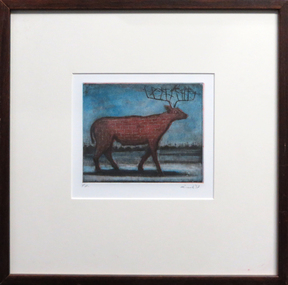 Federation University Art Collection
Work on paper - Artwork - Printmaking, Geoffrey Ricardo, 'Antelope' by Geoffrey Ricardo, 1997
GEOFFREY RICARDO (1964- ) Born Melbourne, Australia 1984-86 Bachelor of Arts (Fine Art), Printmaking, Chisholm Institute of Technology, Melbourne 1987-89 Printing Assistant at Bill Young Studios, Editioning intaglio prints, King Valley, VIC 1988 Full-time Studio Technician at Printmaking Department, Chisholm Institute of Technology, Melbourne 1989-90 Graduate Diploma (Fine Art), Printmaking, Monash University, Melbourne 1991 Traveled to England, France, Spain and USA (Winsor & Newton International Travelling Bursary, National Students Art Prize) Worked in private studios in Gaucin, Spain and New York, USA 1994-95 Master of Fine Arts, Monash University, Melbourne 1995 Guest Lecturer, Victorian College of the Arts, Melbourne Traveled to Europe and America 1996 Guest Lecturer, Royal Melbourne Institute of Technology, Melbourne 1990-98 Sessional Lecturer, Monash University, Melbourne 1998 Traveled to America and Mexico 2001-05 Sessional Lecturer, The Victorian College of the Arts, Melbourne 2003-10 Printmaking Workshops, Warrnambool TAFE, Warrnambool, VIC 2004 Traveled to Europe, Mexico and Cuba 2005 Lecturer, National Art School (Summer School), Sydney Sessional Lecturer, Monash University, Melbourne Lecturer, Institution of Koorie Education, Deakin University, Geelong, VIC SOLO EXHIBITIONS 2012 ‘Collection of Works’ The Art Vault Mildura ‘Deeper Meanings’, The Incinerator Gallery, Melbourne ‘Three Projects’, Australian Galleries, Glenmore Road, Sydney Melbourne Art Fair Stand F33, Australian Galleries, Melbourne 2009 ‘Anno Domino, Antarctica and The Anatomy Lesson’, Australian Galleries Derby Street, Melbourne The Art Vault, Mildura, VIC 2008 MV Orlova (Quark Expeditions), The Drake Passage, Antarctica 2007 ‘Herd’, BMGArt, Adelaide ‘Herd’, Australian Galleries Painting & Sculpture, Sydney 2006 ‘Herd’, Australian Galleries Painting & Sculpture, Melbourne 2004 ‘Recent work’, BMGArt, Adelaide 2003 ‘The Rapunzel Suite and Other New Works’, Australian Galleries Works on Paper, Sydney ‘Recent Works’, Australian Galleries Painting & Sculpture, Melbourne ‘Recent works’, Cowwarr Art Space, Cowwarr, VIC 2002 ‘The Rapunzel Suite’, Australian Galleries Works on Paper, Melbourne ‘Strange Games’, Australian Galleries Works on Paper, Sydney 1999 ‘A Dark City Narrative’, Australian Galleries Works on Paper, Sydney ‘A Dark City Narrative’, Australian Galleries Works on Paper, Melbourne 1998 Cullity Gallery, School of Architecture and Fine Art, University of Western Australia, Perth 1997 Delaney Gallery, Perth Chapman Gallery, Canberra BMGArt, Adelaide ‘Menagerie’, Australian Galleries, Sydney ‘Menagerie’, Australian Galleries, Melbourne 1995 ‘Paintings, Prints and Sculpture’, Australian Galleries, Sydney ‘Prints, Paintings and Sculpture’, Australian Galleries, Melbourne 1994 Lawrence Wilson Art Gallery, University of Western Australia, Perth Graham Galleries + Editions, Brisbane ‘Wishful Thinking, Prints and Sculptures’, Lawrence Wilson Art Gallery, University of Western Australia, Perth 1992 ‘Prints, Sculptures and Watercolours’, Australian Galleries, Melbourne and Sydney 1990 ‘Watercolours, Prints and Small Bronzes’, Australian Galleries, Sydney ‘Paintings, Prints and Sculptures’, Australian Galleries, Melbourne GROUP EXHIBITIONS 2013 ‘Sculpture by the Sea’ Cottlesloe, Western Australia 2012 ‘Brave New World’, Toyota Community Spirit Gallery, Port Melbourne, VIC ‘Sculpture by the Sea’, Bondi, Sydney 2011 ‘Sculpture by the sea’, Aarhus, Denmark ‘Artwork to Tapestry’, Tarrawarra Museum of Art, Healesville, VIC Burnie Print Prize, Burnie Regional Gallery, Burnie, TAS ‘large exhibition of small works’, Australian Galleries, Roylston Street, Sydney ‘large exhibition of small works’, Australian Galleries, Derby Street, Melbourne ‘Nature of the Mark’, Australian Galleries, Smith Street, Melbourne Rick Amor Print Prize, Montsalvat, Eltham, VIC 2010 ‘Summer show’, Australian Galleries, Glenmore Road, Sydney ‘Summer stock show’, Australian Galleries, Smith Street, Melbourne ‘Sub10’, Substation, Melbourne ‘McClelland Sculpture Survey and Award 2010’, McClelland Gallery + Sculpture Park, Langwarrin, VIC ‘Artists’ Prints made with Integrity I’, Australian Galleries, Smith Street, Melbourne Montalto Sculpture Prize, Montalto Vineyard and Olive Grove, Red Hill South, VIC 2009 ‘Artists’ ink: printmaking from the Warrnambool Art Gallery Collection, 1970-2001’, Ararat Regional Art Gallery, Ararat, VIC ‘Lorne Sculpture’ (Winner), Lorne, VIC 2008 ‘Summer Stock Show’, Australian Galleries Smith Street, Melbourne 2007 ARC Biennial (Art, Design and Craft), Queensland University of Technology Art Museum, Brisbane ‘Prints Tokyo: International Print Exhibition’, Tokyo, Japan Seoul International Print, Photo and Edition Works Art Fair, Seoul, Korea Guanlan International Print Biennial, Guanlan, China ‘Summer Stock Show’, Australian Galleries Works on Paper, Sydney ‘Summer Stock Show’, Australian Galleries Painting & Sculpture, Melbourne ‘Summer Stock Show’, Australian Galleries Works on Paper, Melbourne ‘Antipodean Bestiary’, Project Space / Spare Room, RMIT University, Melbourne Montalto Sculpture Prize, Montalto Vineyard and Olive Grove, Red Hill South, VIC McClelland Sculpture Survey and Award 2007, McClelland Gallery + Sculpture Park, Langwarrin, VIC ‘2007: Works from the studio’, Lancaster Press, Melbourne ‘50 - a print exchange portfolio’, Geelong Art Gallery, Geelong, VIC ‘Small Pleasures’, Australian Galleries Painting & Sculpture, Melbourne ‘Stock Show’, Australian Galleries Painting & Sculpture, Melbourne ‘Artists for Kids Culture’, Brightspace, Melbourne 2006 ‘Partnership or perish’, Academy of the Arts, School of Visual and Performing Arts, University of Tasmania, Hobart Libris Awards, Artspace Mackay, Mackay, QLD ‘Summery’, Australian Galleries Painting & Sculpture, Sydney ‘Summer Stock Show’, Australian Galleries Works on Paper, Melbourne ‘Bookish’, Australian Galleries Works on Paper, Melbourne Melbourne Art Fair, Australian Galleries, Melbourne ‘Artists for Kids Culture’, Brightspace, Melbourne ‘50th Anniversary Exhibition’, Australian Galleries Painting & Sculpture, Melbourne 2005 ‘End of Year Group Exhibition’, Australian Galleries Painting & Sculpture, Sydney ‘Contemporary Works on Paper’, Australian Galleries Works on Paper, Melbourne ‘Expansion’, Lancaster Press, Melbourne ‘The Art of Collaboration’, Singapore Tyler Print Institute, Singapore ‘Double take’, Arts Project Australia, Melbourne ‘Small Treasures - 20 emerging and established artists’, TILT Contemporary Art, Melbourne Jacques Cadry Memorial Art Prize, Fox Studios and State Library of NSW, Sydney ‘Tales of the City’, Australian Galleries Painting & Sculpture, Melbourne ‘A Decade of Collecting 1995-2005’, Cairns Regional Gallery, Cairns, QLD ‘Artists for Kids Culture’, Brightspace, Melbourne ‘Surface Tension: 21 Contemporary Australian Printmakers’, University of Tasmania, Launceston, TAS ‘Neo-millenium’, Toyota Community Spirit Gallery, Melbourne 2004 ‘Artists for Kids Culture’, Brightspace, Melbourne ‘Group Exhibition’, Australian Galleries Painting & Sculpture, Melbourne ‘Species’, Australian Galleries Works on Paper, Melbourne ‘In the presence of creatures great and small’, Australian Galleries Works on Paper, Sydney ‘Tapestries from the Victorian Tapestry Workshop’, Australian Galleries, Melbourne ‘Sculpture’, Australian Galleries Painting & Sculpture, Sydney ‘Contemporary Australian Prints’, National Arts Club, New York, USA ‘Contemporary Australian Prints’, Gallery 101, Melbourne ‘Contemporary Australian Prints from the Collection’, Art Gallery of New South Wales, Sydney ‘Bridge’, Toyota Community Spirit Gallery, Melbourne ‘Vivid’, Fortyfive Downstairs, Melbourne Lake Gallery, Paynesville, VIC 2003 ‘Paper matters’, Lawrence Wilson Art Gallery, University of Western Australia, Perth ‘Artists for Kids Culture’, Brightspace, Melbourne ‘Less is more’, BMGArt, Adelaide ‘The ink’s on me: Bill Young master printmaker’, Wangaratta Exhibitions Gallery, Wangaratta, VIC ‘Fantastic and Visionary Art’, Touring: Global Arts Link, QLD; Ipswich Regional Gallery, QLD ; Orange Regional Gallery, NSW; Manning Regional Gallery, NSW; Parramatta Heritage Centre, Sydney; Ballarat Regional Gallery, VIC 2002 Shell Fremantle Print Award, Fremantle Arts Centre, Fremantle, WA ‘Artists for Kids Culture’, Brightspace, Melbourne 2001 Shell Fremantle Print Award, Fremantle Arts Centre, Fremantle, WA ‘Six Degrees of Collaboration’, RMIT Faculty of Art, Design and Communication Gallery, Melbourne ‘Reciprocal Moves’, Warrnambool Art Gallery, Warrnambool, VIC International Print Triennial, Kanagawa, Japan ‘Fantastic Art’, Orange Regional Gallery, Orange, NSW ‘Dancing Made a Man out of Me’, The Switchback Gallery, Monash University, Gippsland, VIC ‘Artists for Kids Culture’, Brightspace, Melbourne ‘Celebration’, Regional touring exhibition, VIC 2000-01 ‘Workings of the Mind: Melbourne Prints of the 1960s to the 1990s’, Touring: Grafton Regional Gallery, NSW; Toowoomba Regional Art Gallery, QLD; Nolan Gallery, Canberra; Bendigo Art Gallery, VIC; PercTucker Regional Gallery, QLD 2000 Shell Fremantle Print Award, Fremantle Arts Centre, Fremantle, WA The Hutchins Art Prize, Long Gallery, Hobart ‘Artists for Kids Culture’, Brightspace, Melbourne 1999 Shell Fremantle Print Award, Fremantle Arts Space, Fremantle, WA ‘We are Australian’, George Adams Gallery, Victorian Arts Centre, Melbourne Rena Ellen Jones Memorial Print Award, Warrnambool Art Gallery, Warrnambool, VIC ‘National Works on Paper’, Mornington Peninsula Gallery, Mornington, VIC ‘Artists for Kids Culture’, Brightspace, Melbourne ‘Pleasure’, Australian Galleries, Melbourne 1998-99 ‘Australian Prints’, Art Gallery of New South Wales, Sydney 1997 ‘KNOCK, KNOCK’, Australian Galleries, Melbourne ‘Woven Colour, The Art of Tapestry’, Dr Earl Lu Gallery, Singapore 1996 M.P.A.C. Print Award, Mornington Peninsula Arts Centre, Mornington, VIC Academy of Art & Culture, Calcutta, India ‘Synergy’, Touring: Lalit Kala Akademi, New Dehli, India; Jehangir Nicholson Gallery, Bombay, India; Birla, India ‘Contemporary Australian Tapestry’, Frederikshavn Kunstmuseum, Denmark; Australia House, London, UK 1995 ‘Interweave - Tapestry A Collaborative Art’, Heide Museum of Modern Art, Melbourne ‘Contemporary Printmakers’, La Trobe Regional Gallery, Morwell, VIC ‘Contemporary Australian Tapestry’, Australian High Commission, Singapore ‘Circus Capers’, Caulfield Arts Complex, Melbourne 1994 M.P.A.C. Print Award, Mornington Peninsula Arts Centre, Mornington, VIC Fremantle Print Award, Fremantle Arts Centre, Fremantle, WA Australian Universities of Visual Art, Australian High Commission, Singapore ‘Prints, Paintings and Sculpture’, BMGArt, Adelaide Fourth Australian Contemporary Art Fair, Royal Exhibition Building, Melbourne 1993 Fremantle Print Award, Fremantle Arts Centre, Fremantle, WA 1992 Fremantle Print Award, Fremantle Arts Centre, Fremantle, WA ‘Transitional Times’, Print Council of Australia, Melbourne ‘Second Kochi International Triennial Exhibition of Prints’, Japan 1991 Henry Worland Memorial Print Prize, Warrnambool Regional Art Gallery, Warrnambool, VIC Fremantle Print Award, Fremantle Arts Centre, Fremantle, WA ‘Table Top Sculpture’, Australian Galleries, Melbourne ‘Art 91’, London Contemporary Art Fair, London, UK 1990 M.P.A.C. Print Prize, Mornington Peninsula Arts Centre, Mornington, VIC Fremantle Print Prize, Fremantle Arts Centre, Fremantle WA ‘The Christmas Show’, Intaglio Printmaker, London, England ‘Australian Contemporary Art’, AZ Gallery, Tokyo, Japan 1989 National Student Art Prize, Mitchell College, Bathurst, NSW Fremantle Print Award, Fremantle Arts Centre, Fremantle, WA City of Doncaster Acquisitive Print Prize, Manningham Gallery, Melbourne ‘Affiliations’, Monash University Gallery, Melbourne 1988 M.P.A.C. Acquisitive Print Prize, Mornington Peninsula Arts Centre, Mornington, VIC Henry Worland Memorial Print Prize, Warrnambool Regional Art Gallery, Warrnambool, VIC 1987 ‘The Comedy Show’, Print Guild, Melbourne ‘Fluxus Art Flow’, Melbourne 1986 Mornington Peninsula Arts Council Acquisitive Print Prize, Mornington Peninsula, VIC Chisolm Institute of Technology, Graduating Students exhibition, Melbourne AWARDS 2013 King Valley Art Prize (printmaking) 2009 Lorne Sculpture Exhibition (Winner), Lorne, VIC 1989 Windsor and Newton International Travelling Bursary, UK Linbrook International First Prize for Printmaking, Australia COMMISSIONS 2005 Tapestry design for Bairnsdale Hospital (woven by the Victorian Tapestry Workshop, Melbourne), Bairnsdale, VIC 1999 Tapestry design ‘Emblem’ (woven by the Victorian Tapestry Workshop, Melbourne), Australia 1995 ‘A Night of Infectious Laughter’ Poster, St Kilda Festival, Melbourne 1994 Tapestry design ‘Elephant Gingham’ (woven by the Victorian Tapestry Workshop, Melbourne), Australia 1993 Tapestry design for the Festival of Perth Official Poster (woven by the Victorian Tapestry Workshop, Melbourne), Perth RESIDENCIES & PROJECTS 2013 ‘Come In Outside’, Collaboration set design for Pocketfool 2011 Mildura Wentworth Arts Festival Project, Mildura, VIC Residency, The Art Vault , Mildura, VIC 2010 ‘Wish’, Collaboration set design for Pocketfool, Artplay, Melbourne The Art Vault (included continuous public flag making workshops which were flown as part of The Wentworth Mildura Art Festival), Mildura, VIC 2009 The Art Vault (included two public printmaking workshops), Mildura, VIC 2008 Artist in residence, MV Orlova, Quark Expeditions, Antarctica 2003 Residency, Bairnsdale Regional Health Service, Bairnsdale, VIC 1998 Residency, School of Architecture & Fine Art, University of Western Australia, Perth 1997 Residency, La Salle/Fia, College of the Arts, Singapore 1996 Artist in residence, Victorian Tapestry Workshop, Melbourne 1993 Reduction Aquatint Workshop & Residency, Graphic Investigation Department, Canberra School of Art, Canberra NB: all residencies have included workshops involving students, children or the general public COLLECTIONS Artbank, Sydney Art Gallery of New South Wales, Sydney Canson Australia Pty Ltd, Australia City of Box Hill, Melbourne City of Whitehorse, Melbourne Downlands College, Toowoomba, QLD Geelong Grammar School, Geelong, VIC Gold Coast City Art Gallery, Gold Coast, QLD Griffith University, Gold Coast, QLD Helensvale High School, Brisbane Holmes à Court Collection, Perth Latrobe Regional Gallery, Morwell, VIC Monash University, Melbourne Mornington Peninsula Arts Council Collection, Mornington, VIC National Gallery of Australia, Canberra National Gallery of Victoria, Melbourne Parliament House Art Collection, Canberra Print Council of Australia, Melbourne Private collections in Australia, Switzerland, USA, UK, Singapore, Germany, Japan, Malaysia, Holland Queen Victoria Museum & Art Gallery, Launceston, TAS Queensland Art Gallery, Brisbane Queensland University of Technology, Brisbane Shire of Diamond Valley, Diamond Valley, VIC Star of the Sea College, Melbourne The Melbourne Club, Melbourne University of Central Queensland, Brisbane University of Technology, Sydney Wagga Wagga Regional Art Gallery, Wagga Wagga, NSW Warrnambool Regional Art Gallery, Warrnambool, VIC PERIODICALS AQ Journal of Contemporary Analysis, Vol. 70, Issue 4, July-August 1998 AQ Journal of Contemporary Analysis, Vol. 70, Issue 6, November-December 1998 AQ Journal of Contemporary Analysis, Vol.71, Issue 7, April 1999 Backhouse, Megan; “Going out of print and back to basics”, The Age, February 2003 Bellamy, Louise; “Renaissance of Western Art”, The Age (A2 section), 26 November 2005 Clabburn, Anna; “Fables and Foibles”, Art Monthly, September 1994 Dutkiewicz, Adam; “Edge of the sublime”, Advertiser, 1 December 2003, p. 76. Erickson, Dorothy; “The Festival that could have been”, The Bulletin, March 1994 Farmer, Alison; “Ricardo makes poster splash”, Sunday Times - Entertainment Extra, 19 September 1993 “Festival taps weaver’s art”, The West Australian, 11February 1994 Fiasco (web-page), March 2003 Jenkins, John; “A Dark City Narrative”, Imprint, Vol. 34, No. 4, 1999 Grishin, Sasha; “Multiplicity – collecting Australian prints”, Australian Art Review, Issue 13, March-June 2007, pp. 52-55 Grishin, Sasha; “Profiles in Print - Geoffrey Ricardo”, Craft Arts International, Issue 76, 2009, pp.1-4 Lloyd, Tim; “The elephant man”, The Advertiser (Review section), December 2007 Manzana Arné, Josep; “De L’Ex-Libris a L’Ex-Webis: Ex-Libris a Internet”, Ex-Libris, Associació Catalana D’Exlibristes, Barcelona, No. 27, July-December 2002, p.11 McDonald, John; “Dreams of hope and menace” The Sydney Morning Herald, 18 March 1995 McMillan, Peter; “Darkness visible”, The Age, 11September 1999 Nelson, Robert; “Circuses can be curated, but not cured”, The Age, 18 January 1995 Nelson, Robert; “Dream Weavers”, The Age, June 1995 Nelson, Robert; “Paen To Ricardo”, Imprint, Vol. 29, No.1, April, 1994 Nelson, Robert; “Revealed: Mother Nature’s vulgar past”, The Age, September 6, 2000 Nelson, Robert; “Riddled with hidden meaning”, The Age, September 8, 1999 Quadrant, April, 1995 Quadrant, Jan/Feb, 1995 Quadrant, October, 1995 Quadrant, November, 1994 “Ricardo’s surreal works at gallery”, Times-Spectator, 25 July 2003, p.7 Snell, Ted; “Art”, The Australian, 18 February1994 Snell, Ted; “Visual arts at the Festival of Perth”, Art Monthly, April 1994 Sunday Arts, ABC TV, 6 May 2007 Timms, Peter; “Geoff Ricardo: emerging from darkness”, Art Monthly, Issue 140, June 2001 Wallace, Dr Carmel; “Ways of seeing Australia”, Asian Art News, May/June 2004 BOOKS & CATALOGUES A Dark City Narrative, Australian Galleries, Melbourne, 1999 ARC Biennial Exhibition (Exhibition catalogue), Queensland University of Technology Art Museum, 2007, pp. 78-79 Clabburn, Anna; “The Collaborative Spirit”, Australian Tapestries: Victorian Tapestry Workshop, 1995, p. 37 Fantastic Art, Orange Regional Gallery, NSW, 2001 Field, Caroline; Herd, catalogue essay, Australian Galleries, Sydney, 2007 Grishin, Sasha; Australian Identities in Printmaking, Wagga Wagga Regional Art Gallery, 2000 Grishin, Sasha; Australian Printmaking in the 1990’s, Craftsman House, 1997 Havighurst, Sophie (Illustrations by Geoffrey Ricardo); When Lester lost his cool, The University of Melbourne, 2007 Kolenberg, Hendrik & Ryan, Anne; Australian Prints, Art Gallery of New South Wales, 1998 Lawrence, Michel; Framed; photographs of Australian Artists, 1998 Modern Australian Tapestries, Victorian Tapestry Workshop, 2000 The Rapunzel Suite, Australian Galleries, Melbourne, 2002 Wallace, Dr Carmel (Essay); Surface Tension, Twenty One Contemporary Australian Printmakers, Gallery 101, Melbourne, 2004 Workings of the Mind : Melbourne Prints of the 1960s to the 1990s, Queensland University of Technology Art Museum, Brisbane, 2000 TELEVISION Sunday Arts, ABC TV, 6 May 2007 Inside Art TV, Channel 31, July 2012Framed coloured aquatint on paperunder image in pencil 'G.P. Ricardo '97'geoffrey ricardo, framed print, printmaking -
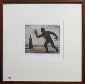 Federation University Art Collection
Work on paper - Artwork - Printmaking, 'Personal Best' by Geoffrey Ricardo, 2000
GEOFFREY RICARDO (1964- ) Born Melbourne, Australia 1984-86 Bachelor of Arts (Fine Art), Printmaking, Chisholm Institute of Technology, Melbourne 1987-89 Printing Assistant at Bill Young Studios, Editioning intaglio prints, King Valley, VIC 1988 Full-time Studio Technician at Printmaking Department, Chisholm Institute of Technology, Melbourne 1989-90 Graduate Diploma (Fine Art), Printmaking, Monash University, Melbourne 1991 Traveled to England, France, Spain and USA (Winsor & Newton International Travelling Bursary, National Students Art Prize) Worked in private studios in Gaucin, Spain and New York, USA 1994-95 Master of Fine Arts, Monash University, Melbourne 1995 Guest Lecturer, Victorian College of the Arts, Melbourne Traveled to Europe and America 1996 Guest Lecturer, Royal Melbourne Institute of Technology, Melbourne 1990-98 Sessional Lecturer, Monash University, Melbourne 1998 Traveled to America and Mexico 2001-05 Sessional Lecturer, The Victorian College of the Arts, Melbourne 2003-10 Printmaking Workshops, Warrnambool TAFE, Warrnambool, VIC 2004 Traveled to Europe, Mexico and Cuba 2005 Lecturer, National Art School (Summer School), Sydney Sessional Lecturer, Monash University, Melbourne Lecturer, Institution of Koorie Education, Deakin University, Geelong, VIC SOLO EXHIBITIONS 2012 ‘Collection of Works’ The Art Vault Mildura ‘Deeper Meanings’, The Incinerator Gallery, Melbourne ‘Three Projects’, Australian Galleries, Glenmore Road, Sydney Melbourne Art Fair Stand F33, Australian Galleries, Melbourne 2009 ‘Anno Domino, Antarctica and The Anatomy Lesson’, Australian Galleries Derby Street, Melbourne The Art Vault, Mildura, VIC 2008 MV Orlova (Quark Expeditions), The Drake Passage, Antarctica 2007 ‘Herd’, BMGArt, Adelaide ‘Herd’, Australian Galleries Painting & Sculpture, Sydney 2006 ‘Herd’, Australian Galleries Painting & Sculpture, Melbourne 2004 ‘Recent work’, BMGArt, Adelaide 2003 ‘The Rapunzel Suite and Other New Works’, Australian Galleries Works on Paper, Sydney ‘Recent Works’, Australian Galleries Painting & Sculpture, Melbourne ‘Recent works’, Cowwarr Art Space, Cowwarr, VIC 2002 ‘The Rapunzel Suite’, Australian Galleries Works on Paper, Melbourne ‘Strange Games’, Australian Galleries Works on Paper, Sydney 1999 ‘A Dark City Narrative’, Australian Galleries Works on Paper, Sydney ‘A Dark City Narrative’, Australian Galleries Works on Paper, Melbourne 1998 Cullity Gallery, School of Architecture and Fine Art, University of Western Australia, Perth 1997 Delaney Gallery, Perth Chapman Gallery, Canberra BMGArt, Adelaide ‘Menagerie’, Australian Galleries, Sydney ‘Menagerie’, Australian Galleries, Melbourne 1995 ‘Paintings, Prints and Sculpture’, Australian Galleries, Sydney ‘Prints, Paintings and Sculpture’, Australian Galleries, Melbourne 1994 Lawrence Wilson Art Gallery, University of Western Australia, Perth Graham Galleries + Editions, Brisbane ‘Wishful Thinking, Prints and Sculptures’, Lawrence Wilson Art Gallery, University of Western Australia, Perth 1992 ‘Prints, Sculptures and Watercolours’, Australian Galleries, Melbourne and Sydney 1990 ‘Watercolours, Prints and Small Bronzes’, Australian Galleries, Sydney ‘Paintings, Prints and Sculptures’, Australian Galleries, Melbourne GROUP EXHIBITIONS 2013 ‘Sculpture by the Sea’ Cottlesloe, Western Australia 2012 ‘Brave New World’, Toyota Community Spirit Gallery, Port Melbourne, VIC ‘Sculpture by the Sea’, Bondi, Sydney 2011 ‘Sculpture by the sea’, Aarhus, Denmark ‘Artwork to Tapestry’, Tarrawarra Museum of Art, Healesville, VIC Burnie Print Prize, Burnie Regional Gallery, Burnie, TAS ‘large exhibition of small works’, Australian Galleries, Roylston Street, Sydney ‘large exhibition of small works’, Australian Galleries, Derby Street, Melbourne ‘Nature of the Mark’, Australian Galleries, Smith Street, Melbourne Rick Amor Print Prize, Montsalvat, Eltham, VIC 2010 ‘Summer show’, Australian Galleries, Glenmore Road, Sydney ‘Summer stock show’, Australian Galleries, Smith Street, Melbourne ‘Sub10’, Substation, Melbourne ‘McClelland Sculpture Survey and Award 2010’, McClelland Gallery + Sculpture Park, Langwarrin, VIC ‘Artists’ Prints made with Integrity I’, Australian Galleries, Smith Street, Melbourne Montalto Sculpture Prize, Montalto Vineyard and Olive Grove, Red Hill South, VIC 2009 ‘Artists’ ink: printmaking from the Warrnambool Art Gallery Collection, 1970-2001’, Ararat Regional Art Gallery, Ararat, VIC ‘Lorne Sculpture’ (Winner), Lorne, VIC 2008 ‘Summer Stock Show’, Australian Galleries Smith Street, Melbourne 2007 ARC Biennial (Art, Design and Craft), Queensland University of Technology Art Museum, Brisbane ‘Prints Tokyo: International Print Exhibition’, Tokyo, Japan Seoul International Print, Photo and Edition Works Art Fair, Seoul, Korea Guanlan International Print Biennial, Guanlan, China ‘Summer Stock Show’, Australian Galleries Works on Paper, Sydney ‘Summer Stock Show’, Australian Galleries Painting & Sculpture, Melbourne ‘Summer Stock Show’, Australian Galleries Works on Paper, Melbourne ‘Antipodean Bestiary’, Project Space / Spare Room, RMIT University, Melbourne Montalto Sculpture Prize, Montalto Vineyard and Olive Grove, Red Hill South, VIC McClelland Sculpture Survey and Award 2007, McClelland Gallery + Sculpture Park, Langwarrin, VIC ‘2007: Works from the studio’, Lancaster Press, Melbourne ‘50 - a print exchange portfolio’, Geelong Art Gallery, Geelong, VIC ‘Small Pleasures’, Australian Galleries Painting & Sculpture, Melbourne ‘Stock Show’, Australian Galleries Painting & Sculpture, Melbourne ‘Artists for Kids Culture’, Brightspace, Melbourne 2006 ‘Partnership or perish’, Academy of the Arts, School of Visual and Performing Arts, University of Tasmania, Hobart Libris Awards, Artspace Mackay, Mackay, QLD ‘Summery’, Australian Galleries Painting & Sculpture, Sydney ‘Summer Stock Show’, Australian Galleries Works on Paper, Melbourne ‘Bookish’, Australian Galleries Works on Paper, Melbourne Melbourne Art Fair, Australian Galleries, Melbourne ‘Artists for Kids Culture’, Brightspace, Melbourne ‘50th Anniversary Exhibition’, Australian Galleries Painting & Sculpture, Melbourne 2005 ‘End of Year Group Exhibition’, Australian Galleries Painting & Sculpture, Sydney ‘Contemporary Works on Paper’, Australian Galleries Works on Paper, Melbourne ‘Expansion’, Lancaster Press, Melbourne ‘The Art of Collaboration’, Singapore Tyler Print Institute, Singapore ‘Double take’, Arts Project Australia, Melbourne ‘Small Treasures - 20 emerging and established artists’, TILT Contemporary Art, Melbourne Jacques Cadry Memorial Art Prize, Fox Studios and State Library of NSW, Sydney ‘Tales of the City’, Australian Galleries Painting & Sculpture, Melbourne ‘A Decade of Collecting 1995-2005’, Cairns Regional Gallery, Cairns, QLD ‘Artists for Kids Culture’, Brightspace, Melbourne ‘Surface Tension: 21 Contemporary Australian Printmakers’, University of Tasmania, Launceston, TAS ‘Neo-millenium’, Toyota Community Spirit Gallery, Melbourne 2004 ‘Artists for Kids Culture’, Brightspace, Melbourne ‘Group Exhibition’, Australian Galleries Painting & Sculpture, Melbourne ‘Species’, Australian Galleries Works on Paper, Melbourne ‘In the presence of creatures great and small’, Australian Galleries Works on Paper, Sydney ‘Tapestries from the Victorian Tapestry Workshop’, Australian Galleries, Melbourne ‘Sculpture’, Australian Galleries Painting & Sculpture, Sydney ‘Contemporary Australian Prints’, National Arts Club, New York, USA ‘Contemporary Australian Prints’, Gallery 101, Melbourne ‘Contemporary Australian Prints from the Collection’, Art Gallery of New South Wales, Sydney ‘Bridge’, Toyota Community Spirit Gallery, Melbourne ‘Vivid’, Fortyfive Downstairs, Melbourne Lake Gallery, Paynesville, VIC 2003 ‘Paper matters’, Lawrence Wilson Art Gallery, University of Western Australia, Perth ‘Artists for Kids Culture’, Brightspace, Melbourne ‘Less is more’, BMGArt, Adelaide ‘The ink’s on me: Bill Young master printmaker’, Wangaratta Exhibitions Gallery, Wangaratta, VIC ‘Fantastic and Visionary Art’, Touring: Global Arts Link, QLD; Ipswich Regional Gallery, QLD ; Orange Regional Gallery, NSW; Manning Regional Gallery, NSW; Parramatta Heritage Centre, Sydney; Ballarat Regional Gallery, VIC 2002 Shell Fremantle Print Award, Fremantle Arts Centre, Fremantle, WA ‘Artists for Kids Culture’, Brightspace, Melbourne 2001 Shell Fremantle Print Award, Fremantle Arts Centre, Fremantle, WA ‘Six Degrees of Collaboration’, RMIT Faculty of Art, Design and Communication Gallery, Melbourne ‘Reciprocal Moves’, Warrnambool Art Gallery, Warrnambool, VIC International Print Triennial, Kanagawa, Japan ‘Fantastic Art’, Orange Regional Gallery, Orange, NSW ‘Dancing Made a Man out of Me’, The Switchback Gallery, Monash University, Gippsland, VIC ‘Artists for Kids Culture’, Brightspace, Melbourne ‘Celebration’, Regional touring exhibition, VIC 2000-01 ‘Workings of the Mind: Melbourne Prints of the 1960s to the 1990s’, Touring: Grafton Regional Gallery, NSW; Toowoomba Regional Art Gallery, QLD; Nolan Gallery, Canberra; Bendigo Art Gallery, VIC; PercTucker Regional Gallery, QLD 2000 Shell Fremantle Print Award, Fremantle Arts Centre, Fremantle, WA The Hutchins Art Prize, Long Gallery, Hobart ‘Artists for Kids Culture’, Brightspace, Melbourne 1999 Shell Fremantle Print Award, Fremantle Arts Space, Fremantle, WA ‘We are Australian’, George Adams Gallery, Victorian Arts Centre, Melbourne Rena Ellen Jones Memorial Print Award, Warrnambool Art Gallery, Warrnambool, VIC ‘National Works on Paper’, Mornington Peninsula Gallery, Mornington, VIC ‘Artists for Kids Culture’, Brightspace, Melbourne ‘Pleasure’, Australian Galleries, Melbourne 1998-99 ‘Australian Prints’, Art Gallery of New South Wales, Sydney 1997 ‘KNOCK, KNOCK’, Australian Galleries, Melbourne ‘Woven Colour, The Art of Tapestry’, Dr Earl Lu Gallery, Singapore 1996 M.P.A.C. Print Award, Mornington Peninsula Arts Centre, Mornington, VIC Academy of Art & Culture, Calcutta, India ‘Synergy’, Touring: Lalit Kala Akademi, New Dehli, India; Jehangir Nicholson Gallery, Bombay, India; Birla, India ‘Contemporary Australian Tapestry’, Frederikshavn Kunstmuseum, Denmark; Australia House, London, UK 1995 ‘Interweave - Tapestry A Collaborative Art’, Heide Museum of Modern Art, Melbourne ‘Contemporary Printmakers’, La Trobe Regional Gallery, Morwell, VIC ‘Contemporary Australian Tapestry’, Australian High Commission, Singapore ‘Circus Capers’, Caulfield Arts Complex, Melbourne 1994 M.P.A.C. Print Award, Mornington Peninsula Arts Centre, Mornington, VIC Fremantle Print Award, Fremantle Arts Centre, Fremantle, WA Australian Universities of Visual Art, Australian High Commission, Singapore ‘Prints, Paintings and Sculpture’, BMGArt, Adelaide Fourth Australian Contemporary Art Fair, Royal Exhibition Building, Melbourne 1993 Fremantle Print Award, Fremantle Arts Centre, Fremantle, WA 1992 Fremantle Print Award, Fremantle Arts Centre, Fremantle, WA ‘Transitional Times’, Print Council of Australia, Melbourne ‘Second Kochi International Triennial Exhibition of Prints’, Japan 1991 Henry Worland Memorial Print Prize, Warrnambool Regional Art Gallery, Warrnambool, VIC Fremantle Print Award, Fremantle Arts Centre, Fremantle, WA ‘Table Top Sculpture’, Australian Galleries, Melbourne ‘Art 91’, London Contemporary Art Fair, London, UK 1990 M.P.A.C. Print Prize, Mornington Peninsula Arts Centre, Mornington, VIC Fremantle Print Prize, Fremantle Arts Centre, Fremantle WA ‘The Christmas Show’, Intaglio Printmaker, London, England ‘Australian Contemporary Art’, AZ Gallery, Tokyo, Japan 1989 National Student Art Prize, Mitchell College, Bathurst, NSW Fremantle Print Award, Fremantle Arts Centre, Fremantle, WA City of Doncaster Acquisitive Print Prize, Manningham Gallery, Melbourne ‘Affiliations’, Monash University Gallery, Melbourne 1988 M.P.A.C. Acquisitive Print Prize, Mornington Peninsula Arts Centre, Mornington, VIC Henry Worland Memorial Print Prize, Warrnambool Regional Art Gallery, Warrnambool, VIC 1987 ‘The Comedy Show’, Print Guild, Melbourne ‘Fluxus Art Flow’, Melbourne 1986 Mornington Peninsula Arts Council Acquisitive Print Prize, Mornington Peninsula, VIC Chisolm Institute of Technology, Graduating Students exhibition, Melbourne AWARDS 2013 King Valley Art Prize (printmaking) 2009 Lorne Sculpture Exhibition (Winner), Lorne, VIC 1989 Windsor and Newton International Travelling Bursary, UK Linbrook International First Prize for Printmaking, Australia COMMISSIONS 2005 Tapestry design for Bairnsdale Hospital (woven by the Victorian Tapestry Workshop, Melbourne), Bairnsdale, VIC 1999 Tapestry design ‘Emblem’ (woven by the Victorian Tapestry Workshop, Melbourne), Australia 1995 ‘A Night of Infectious Laughter’ Poster, St Kilda Festival, Melbourne 1994 Tapestry design ‘Elephant Gingham’ (woven by the Victorian Tapestry Workshop, Melbourne), Australia 1993 Tapestry design for the Festival of Perth Official Poster (woven by the Victorian Tapestry Workshop, Melbourne), Perth RESIDENCIES & PROJECTS 2013 ‘Come In Outside’, Collaboration set design for Pocketfool 2011 Mildura Wentworth Arts Festival Project, Mildura, VIC Residency, The Art Vault , Mildura, VIC 2010 ‘Wish’, Collaboration set design for Pocketfool, Artplay, Melbourne The Art Vault (included continuous public flag making workshops which were flown as part of The Wentworth Mildura Art Festival), Mildura, VIC 2009 The Art Vault (included two public printmaking workshops), Mildura, VIC 2008 Artist in residence, MV Orlova, Quark Expeditions, Antarctica 2003 Residency, Bairnsdale Regional Health Service, Bairnsdale, VIC 1998 Residency, School of Architecture & Fine Art, University of Western Australia, Perth 1997 Residency, La Salle/Fia, College of the Arts, Singapore 1996 Artist in residence, Victorian Tapestry Workshop, Melbourne 1993 Reduction Aquatint Workshop & Residency, Graphic Investigation Department, Canberra School of Art, Canberra NB: all residencies have included workshops involving students, children or the general public COLLECTIONS Artbank, Sydney Art Gallery of New South Wales, Sydney Canson Australia Pty Ltd, Australia City of Box Hill, Melbourne City of Whitehorse, Melbourne Downlands College, Toowoomba, QLD Geelong Grammar School, Geelong, VIC Gold Coast City Art Gallery, Gold Coast, QLD Griffith University, Gold Coast, QLD Helensvale High School, Brisbane Holmes à Court Collection, Perth Latrobe Regional Gallery, Morwell, VIC Monash University, Melbourne Mornington Peninsula Arts Council Collection, Mornington, VIC National Gallery of Australia, Canberra National Gallery of Victoria, Melbourne Parliament House Art Collection, Canberra Print Council of Australia, Melbourne Private collections in Australia, Switzerland, USA, UK, Singapore, Germany, Japan, Malaysia, Holland Queen Victoria Museum & Art Gallery, Launceston, TAS Queensland Art Gallery, Brisbane Queensland University of Technology, Brisbane Shire of Diamond Valley, Diamond Valley, VIC Star of the Sea College, Melbourne The Melbourne Club, Melbourne University of Central Queensland, Brisbane University of Technology, Sydney Wagga Wagga Regional Art Gallery, Wagga Wagga, NSW Warrnambool Regional Art Gallery, Warrnambool, VIC BIBLIOGRAPHY PERIODICALS AQ Journal of Contemporary Analysis, Vol. 70, Issue 4, July-August 1998 AQ Journal of Contemporary Analysis, Vol. 70, Issue 6, November-December 1998 AQ Journal of Contemporary Analysis, Vol.71, Issue 7, April 1999 Backhouse, Megan; “Going out of print and back to basics”, The Age, February 2003 Bellamy, Louise; “Renaissance of Western Art”, The Age (A2 section), 26 November 2005 Clabburn, Anna; “Fables and Foibles”, Art Monthly, September 1994 Dutkiewicz, Adam; “Edge of the sublime”, Advertiser, 1 December 2003, p. 76. Erickson, Dorothy; “The Festival that could have been”, The Bulletin, March 1994 Farmer, Alison; “Ricardo makes poster splash”, Sunday Times - Entertainment Extra, 19 September 1993 “Festival taps weaver’s art”, The West Australian, 11February 1994 Fiasco (web-page), March 2003 Jenkins, John; “A Dark City Narrative”, Imprint, Vol. 34, No. 4, 1999 Grishin, Sasha; “Multiplicity – collecting Australian prints”, Australian Art Review, Issue 13, March-June 2007, pp. 52-55 Grishin, Sasha; “Profiles in Print - Geoffrey Ricardo”, Craft Arts International, Issue 76, 2009, pp.1-4 Lloyd, Tim; “The elephant man”, The Advertiser (Review section), December 2007 Manzana Arné, Josep; “De L’Ex-Libris a L’Ex-Webis: Ex-Libris a Internet”, Ex-Libris, Associació Catalana D’Exlibristes, Barcelona, No. 27, July-December 2002, p.11 McDonald, John; “Dreams of hope and menace” The Sydney Morning Herald, 18 March 1995 McMillan, Peter; “Darkness visible”, The Age, 11September 1999 Nelson, Robert; “Circuses can be curated, but not cured”, The Age, 18 January 1995 Nelson, Robert; “Dream Weavers”, The Age, June 1995 Nelson, Robert; “Paen To Ricardo”, Imprint, Vol. 29, No.1, April, 1994 Nelson, Robert; “Revealed: Mother Nature’s vulgar past”, The Age, September 6, 2000 Nelson, Robert; “Riddled with hidden meaning”, The Age, September 8, 1999 Quadrant, April, 1995 Quadrant, Jan/Feb, 1995 Quadrant, October, 1995 Quadrant, November, 1994 “Ricardo’s surreal works at gallery”, Times-Spectator, 25 July 2003, p.7 Snell, Ted; “Art”, The Australian, 18 February1994 Snell, Ted; “Visual arts at the Festival of Perth”, Art Monthly, April 1994 Sunday Arts, ABC TV, 6 May 2007 Timms, Peter; “Geoff Ricardo: emerging from darkness”, Art Monthly, Issue 140, June 2001 Wallace, Dr Carmel; “Ways of seeing Australia”, Asian Art News, May/June 2004 BOOKS & CATALOGUES A Dark City Narrative, Australian Galleries, Melbourne, 1999 ARC Biennial Exhibition (Exhibition catalogue), Queensland University of Technology Art Museum, 2007, pp. 78-79 Clabburn, Anna; “The Collaborative Spirit”, Australian Tapestries: Victorian Tapestry Workshop, 1995, p. 37 Fantastic Art, Orange Regional Gallery, NSW, 2001 Field, Caroline; Herd, catalogue essay, Australian Galleries, Sydney, 2007 Grishin, Sasha; Australian Identities in Printmaking, Wagga Wagga Regional Art Gallery, 2000 Grishin, Sasha; Australian Printmaking in the 1990’s, Craftsman House, 1997 Havighurst, Sophie (Illustrations by Geoffrey Ricardo); When Lester lost his cool, The University of Melbourne, 2007 Kolenberg, Hendrik & Ryan, Anne; Australian Prints, Art Gallery of New South Wales, 1998 Lawrence, Michel; Framed; photographs of Australian Artists, 1998 Modern Australian Tapestries, Victorian Tapestry Workshop, 2000 The Rapunzel Suite, Australian Galleries, Melbourne, 2002 Wallace, Dr Carmel (Essay); Surface Tension, Twenty One Contemporary Australian Printmakers, Gallery 101, Melbourne, 2004 Workings of the Mind : Melbourne Prints of the 1960s to the 1990s, Queensland University of Technology Art Museum, Brisbane, 2000 TELEVISION Sunday Arts, ABC TV, 6 May 2007 Inside Art TV, Channel 31, July 2012Framed coloured etchingon paper. Donated through the Australian Government's Cultural Gifts Programme by Katherine Littlewood.Under image in pencil ' state proof ', "personal best" Ricardo 2000'. From Strange Games series. geoffrey ricardo, printmaking, framed print, available framed, available, sport -
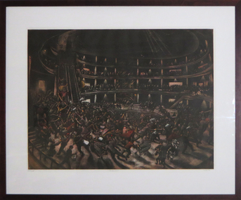 Federation University Art Collection
Work on paper - Artwork - Printmaking, Geoffrey Ricardo, "The Urbane Heart" by Geoffrey Ricardo, 1999
GEOFFREY RICARDO (1964- ) Born Melbourne, Australia 1984-86 Bachelor of Arts (Fine Art), Printmaking, Chisholm Institute of Technology, Melbourne 1987-89 Printing Assistant at Bill Young Studios, Editioning intaglio prints, King Valley, VIC 1988 Full-time Studio Technician at Printmaking Department, Chisholm Institute of Technology, Melbourne 1989-90 Graduate Diploma (Fine Art), Printmaking, Monash University, Melbourne 1991 Traveled to England, France, Spain and USA (Winsor & Newton International Travelling Bursary, National Students Art Prize) Worked in private studios in Gaucin, Spain and New York, USA 1994-95 Master of Fine Arts, Monash University, Melbourne 1995 Guest Lecturer, Victorian College of the Arts, Melbourne Traveled to Europe and America 1996 Guest Lecturer, Royal Melbourne Institute of Technology, Melbourne 1990-98 Sessional Lecturer, Monash University, Melbourne 1998 Traveled to America and Mexico 2001-05 Sessional Lecturer, The Victorian College of the Arts, Melbourne 2003-10 Printmaking Workshops, Warrnambool TAFE, Warrnambool, VIC 2004 Traveled to Europe, Mexico and Cuba 2005 Lecturer, National Art School (Summer School), Sydney Sessional Lecturer, Monash University, Melbourne Lecturer, Institution of Koorie Education, Deakin University, Geelong, VIC SOLO EXHIBITIONS 2012 ‘Collection of Works’ The Art Vault Mildura ‘Deeper Meanings’, The Incinerator Gallery, Melbourne ‘Three Projects’, Australian Galleries, Glenmore Road, Sydney Melbourne Art Fair Stand F33, Australian Galleries, Melbourne 2009 ‘Anno Domino, Antarctica and The Anatomy Lesson’, Australian Galleries Derby Street, Melbourne The Art Vault, Mildura, VIC 2008 MV Orlova (Quark Expeditions), The Drake Passage, Antarctica 2007 ‘Herd’, BMGArt, Adelaide ‘Herd’, Australian Galleries Painting & Sculpture, Sydney 2006 ‘Herd’, Australian Galleries Painting & Sculpture, Melbourne 2004 ‘Recent work’, BMGArt, Adelaide 2003 ‘The Rapunzel Suite and Other New Works’, Australian Galleries Works on Paper, Sydney ‘Recent Works’, Australian Galleries Painting & Sculpture, Melbourne ‘Recent works’, Cowwarr Art Space, Cowwarr, VIC 2002 ‘The Rapunzel Suite’, Australian Galleries Works on Paper, Melbourne ‘Strange Games’, Australian Galleries Works on Paper, Sydney 1999 ‘A Dark City Narrative’, Australian Galleries Works on Paper, Sydney ‘A Dark City Narrative’, Australian Galleries Works on Paper, Melbourne 1998 Cullity Gallery, School of Architecture and Fine Art, University of Western Australia, Perth 1997 Delaney Gallery, Perth Chapman Gallery, Canberra BMGArt, Adelaide ‘Menagerie’, Australian Galleries, Sydney ‘Menagerie’, Australian Galleries, Melbourne 1995 ‘Paintings, Prints and Sculpture’, Australian Galleries, Sydney ‘Prints, Paintings and Sculpture’, Australian Galleries, Melbourne 1994 Lawrence Wilson Art Gallery, University of Western Australia, Perth Graham Galleries + Editions, Brisbane ‘Wishful Thinking, Prints and Sculptures’, Lawrence Wilson Art Gallery, University of Western Australia, Perth 1992 ‘Prints, Sculptures and Watercolours’, Australian Galleries, Melbourne and Sydney 1990 ‘Watercolours, Prints and Small Bronzes’, Australian Galleries, Sydney ‘Paintings, Prints and Sculptures’, Australian Galleries, Melbourne GROUP EXHIBITIONS 2013 ‘Sculpture by the Sea’ Cottlesloe, Western Australia 2012 ‘Brave New World’, Toyota Community Spirit Gallery, Port Melbourne, VIC ‘Sculpture by the Sea’, Bondi, Sydney 2011 ‘Sculpture by the sea’, Aarhus, Denmark ‘Artwork to Tapestry’, Tarrawarra Museum of Art, Healesville, VIC Burnie Print Prize, Burnie Regional Gallery, Burnie, TAS ‘large exhibition of small works’, Australian Galleries, Roylston Street, Sydney ‘large exhibition of small works’, Australian Galleries, Derby Street, Melbourne ‘Nature of the Mark’, Australian Galleries, Smith Street, Melbourne Rick Amor Print Prize, Montsalvat, Eltham, VIC 2010 ‘Summer show’, Australian Galleries, Glenmore Road, Sydney ‘Summer stock show’, Australian Galleries, Smith Street, Melbourne ‘Sub10’, Substation, Melbourne ‘McClelland Sculpture Survey and Award 2010’, McClelland Gallery + Sculpture Park, Langwarrin, VIC ‘Artists’ Prints made with Integrity I’, Australian Galleries, Smith Street, Melbourne Montalto Sculpture Prize, Montalto Vineyard and Olive Grove, Red Hill South, VIC 2009 ‘Artists’ ink: printmaking from the Warrnambool Art Gallery Collection, 1970-2001’, Ararat Regional Art Gallery, Ararat, VIC ‘Lorne Sculpture’ (Winner), Lorne, VIC 2008 ‘Summer Stock Show’, Australian Galleries Smith Street, Melbourne 2007 ARC Biennial (Art, Design and Craft), Queensland University of Technology Art Museum, Brisbane ‘Prints Tokyo: International Print Exhibition’, Tokyo, Japan Seoul International Print, Photo and Edition Works Art Fair, Seoul, Korea Guanlan International Print Biennial, Guanlan, China ‘Summer Stock Show’, Australian Galleries Works on Paper, Sydney ‘Summer Stock Show’, Australian Galleries Painting & Sculpture, Melbourne ‘Summer Stock Show’, Australian Galleries Works on Paper, Melbourne ‘Antipodean Bestiary’, Project Space / Spare Room, RMIT University, Melbourne Montalto Sculpture Prize, Montalto Vineyard and Olive Grove, Red Hill South, VIC McClelland Sculpture Survey and Award 2007, McClelland Gallery + Sculpture Park, Langwarrin, VIC ‘2007: Works from the studio’, Lancaster Press, Melbourne ‘50 - a print exchange portfolio’, Geelong Art Gallery, Geelong, VIC ‘Small Pleasures’, Australian Galleries Painting & Sculpture, Melbourne ‘Stock Show’, Australian Galleries Painting & Sculpture, Melbourne ‘Artists for Kids Culture’, Brightspace, Melbourne 2006 ‘Partnership or perish’, Academy of the Arts, School of Visual and Performing Arts, University of Tasmania, Hobart Libris Awards, Artspace Mackay, Mackay, QLD ‘Summery’, Australian Galleries Painting & Sculpture, Sydney ‘Summer Stock Show’, Australian Galleries Works on Paper, Melbourne ‘Bookish’, Australian Galleries Works on Paper, Melbourne Melbourne Art Fair, Australian Galleries, Melbourne ‘Artists for Kids Culture’, Brightspace, Melbourne ‘50th Anniversary Exhibition’, Australian Galleries Painting & Sculpture, Melbourne 2005 ‘End of Year Group Exhibition’, Australian Galleries Painting & Sculpture, Sydney ‘Contemporary Works on Paper’, Australian Galleries Works on Paper, Melbourne ‘Expansion’, Lancaster Press, Melbourne ‘The Art of Collaboration’, Singapore Tyler Print Institute, Singapore ‘Double take’, Arts Project Australia, Melbourne ‘Small Treasures - 20 emerging and established artists’, TILT Contemporary Art, Melbourne Jacques Cadry Memorial Art Prize, Fox Studios and State Library of NSW, Sydney ‘Tales of the City’, Australian Galleries Painting & Sculpture, Melbourne ‘A Decade of Collecting 1995-2005’, Cairns Regional Gallery, Cairns, QLD ‘Artists for Kids Culture’, Brightspace, Melbourne ‘Surface Tension: 21 Contemporary Australian Printmakers’, University of Tasmania, Launceston, TAS ‘Neo-millenium’, Toyota Community Spirit Gallery, Melbourne 2004 ‘Artists for Kids Culture’, Brightspace, Melbourne ‘Group Exhibition’, Australian Galleries Painting & Sculpture, Melbourne ‘Species’, Australian Galleries Works on Paper, Melbourne ‘In the presence of creatures great and small’, Australian Galleries Works on Paper, Sydney ‘Tapestries from the Victorian Tapestry Workshop’, Australian Galleries, Melbourne ‘Sculpture’, Australian Galleries Painting & Sculpture, Sydney ‘Contemporary Australian Prints’, National Arts Club, New York, USA ‘Contemporary Australian Prints’, Gallery 101, Melbourne ‘Contemporary Australian Prints from the Collection’, Art Gallery of New South Wales, Sydney ‘Bridge’, Toyota Community Spirit Gallery, Melbourne ‘Vivid’, Fortyfive Downstairs, Melbourne Lake Gallery, Paynesville, VIC 2003 ‘Paper matters’, Lawrence Wilson Art Gallery, University of Western Australia, Perth ‘Artists for Kids Culture’, Brightspace, Melbourne ‘Less is more’, BMGArt, Adelaide ‘The ink’s on me: Bill Young master printmaker’, Wangaratta Exhibitions Gallery, Wangaratta, VIC ‘Fantastic and Visionary Art’, Touring: Global Arts Link, QLD; Ipswich Regional Gallery, QLD ; Orange Regional Gallery, NSW; Manning Regional Gallery, NSW; Parramatta Heritage Centre, Sydney; Ballarat Regional Gallery, VIC 2002 Shell Fremantle Print Award, Fremantle Arts Centre, Fremantle, WA ‘Artists for Kids Culture’, Brightspace, Melbourne 2001 Shell Fremantle Print Award, Fremantle Arts Centre, Fremantle, WA ‘Six Degrees of Collaboration’, RMIT Faculty of Art, Design and Communication Gallery, Melbourne ‘Reciprocal Moves’, Warrnambool Art Gallery, Warrnambool, VIC International Print Triennial, Kanagawa, Japan ‘Fantastic Art’, Orange Regional Gallery, Orange, NSW ‘Dancing Made a Man out of Me’, The Switchback Gallery, Monash University, Gippsland, VIC ‘Artists for Kids Culture’, Brightspace, Melbourne ‘Celebration’, Regional touring exhibition, VIC 2000-01 ‘Workings of the Mind: Melbourne Prints of the 1960s to the 1990s’, Touring: Grafton Regional Gallery, NSW; Toowoomba Regional Art Gallery, QLD; Nolan Gallery, Canberra; Bendigo Art Gallery, VIC; PercTucker Regional Gallery, QLD 2000 Shell Fremantle Print Award, Fremantle Arts Centre, Fremantle, WA The Hutchins Art Prize, Long Gallery, Hobart ‘Artists for Kids Culture’, Brightspace, Melbourne 1999 Shell Fremantle Print Award, Fremantle Arts Space, Fremantle, WA ‘We are Australian’, George Adams Gallery, Victorian Arts Centre, Melbourne Rena Ellen Jones Memorial Print Award, Warrnambool Art Gallery, Warrnambool, VIC ‘National Works on Paper’, Mornington Peninsula Gallery, Mornington, VIC ‘Artists for Kids Culture’, Brightspace, Melbourne ‘Pleasure’, Australian Galleries, Melbourne 1998-99 ‘Australian Prints’, Art Gallery of New South Wales, Sydney 1997 ‘KNOCK, KNOCK’, Australian Galleries, Melbourne ‘Woven Colour, The Art of Tapestry’, Dr Earl Lu Gallery, Singapore 1996 M.P.A.C. Print Award, Mornington Peninsula Arts Centre, Mornington, VIC Academy of Art & Culture, Calcutta, India ‘Synergy’, Touring: Lalit Kala Akademi, New Dehli, India; Jehangir Nicholson Gallery, Bombay, India; Birla, India ‘Contemporary Australian Tapestry’, Frederikshavn Kunstmuseum, Denmark; Australia House, London, UK 1995 ‘Interweave - Tapestry A Collaborative Art’, Heide Museum of Modern Art, Melbourne ‘Contemporary Printmakers’, La Trobe Regional Gallery, Morwell, VIC ‘Contemporary Australian Tapestry’, Australian High Commission, Singapore ‘Circus Capers’, Caulfield Arts Complex, Melbourne 1994 M.P.A.C. Print Award, Mornington Peninsula Arts Centre, Mornington, VIC Fremantle Print Award, Fremantle Arts Centre, Fremantle, WA Australian Universities of Visual Art, Australian High Commission, Singapore ‘Prints, Paintings and Sculpture’, BMGArt, Adelaide Fourth Australian Contemporary Art Fair, Royal Exhibition Building, Melbourne 1993 Fremantle Print Award, Fremantle Arts Centre, Fremantle, WA 1992 Fremantle Print Award, Fremantle Arts Centre, Fremantle, WA ‘Transitional Times’, Print Council of Australia, Melbourne ‘Second Kochi International Triennial Exhibition of Prints’, Japan 1991 Henry Worland Memorial Print Prize, Warrnambool Regional Art Gallery, Warrnambool, VIC Fremantle Print Award, Fremantle Arts Centre, Fremantle, WA ‘Table Top Sculpture’, Australian Galleries, Melbourne ‘Art 91’, London Contemporary Art Fair, London, UK 1990 M.P.A.C. Print Prize, Mornington Peninsula Arts Centre, Mornington, VIC Fremantle Print Prize, Fremantle Arts Centre, Fremantle WA ‘The Christmas Show’, Intaglio Printmaker, London, England ‘Australian Contemporary Art’, AZ Gallery, Tokyo, Japan 1989 National Student Art Prize, Mitchell College, Bathurst, NSW Fremantle Print Award, Fremantle Arts Centre, Fremantle, WA City of Doncaster Acquisitive Print Prize, Manningham Gallery, Melbourne ‘Affiliations’, Monash University Gallery, Melbourne 1988 M.P.A.C. Acquisitive Print Prize, Mornington Peninsula Arts Centre, Mornington, VIC Henry Worland Memorial Print Prize, Warrnambool Regional Art Gallery, Warrnambool, VIC 1987 ‘The Comedy Show’, Print Guild, Melbourne ‘Fluxus Art Flow’, Melbourne 1986 Mornington Peninsula Arts Council Acquisitive Print Prize, Mornington Peninsula, VIC Chisolm Institute of Technology, Graduating Students exhibition, Melbourne AWARDS 2013 King Valley Art Prize (printmaking) 2009 Lorne Sculpture Exhibition (Winner), Lorne, VIC 1989 Windsor and Newton International Travelling Bursary, UK Linbrook International First Prize for Printmaking, Australia COMMISSIONS 2005 Tapestry design for Bairnsdale Hospital (woven by the Victorian Tapestry Workshop, Melbourne), Bairnsdale, VIC 1999 Tapestry design ‘Emblem’ (woven by the Victorian Tapestry Workshop, Melbourne), Australia 1995 ‘A Night of Infectious Laughter’ Poster, St Kilda Festival, Melbourne 1994 Tapestry design ‘Elephant Gingham’ (woven by the Victorian Tapestry Workshop, Melbourne), Australia 1993 Tapestry design for the Festival of Perth Official Poster (woven by the Victorian Tapestry Workshop, Melbourne), Perth RESIDENCIES & PROJECTS 2013 ‘Come In Outside’, Collaboration set design for Pocketfool 2011 Mildura Wentworth Arts Festival Project, Mildura, VIC Residency, The Art Vault , Mildura, VIC 2010 ‘Wish’, Collaboration set design for Pocketfool, Artplay, Melbourne The Art Vault (included continuous public flag making workshops which were flown as part of The Wentworth Mildura Art Festival), Mildura, VIC 2009 The Art Vault (included two public printmaking workshops), Mildura, VIC 2008 Artist in residence, MV Orlova, Quark Expeditions, Antarctica 2003 Residency, Bairnsdale Regional Health Service, Bairnsdale, VIC 1998 Residency, School of Architecture & Fine Art, University of Western Australia, Perth 1997 Residency, La Salle/Fia, College of the Arts, Singapore 1996 Artist in residence, Victorian Tapestry Workshop, Melbourne 1993 Reduction Aquatint Workshop & Residency, Graphic Investigation Department, Canberra School of Art, Canberra NB: all residencies have included workshops involving students, children or the general public COLLECTIONS Artbank, Sydney Art Gallery of New South Wales, Sydney Canson Australia Pty Ltd, Australia City of Box Hill, Melbourne City of Whitehorse, Melbourne Downlands College, Toowoomba, QLD Geelong Grammar School, Geelong, VIC Gold Coast City Art Gallery, Gold Coast, QLD Griffith University, Gold Coast, QLD Helensvale High School, Brisbane Holmes à Court Collection, Perth Latrobe Regional Gallery, Morwell, VIC Monash University, Melbourne Mornington Peninsula Arts Council Collection, Mornington, VIC National Gallery of Australia, Canberra National Gallery of Victoria, Melbourne Parliament House Art Collection, Canberra Print Council of Australia, Melbourne Private collections in Australia, Switzerland, USA, UK, Singapore, Germany, Japan, Malaysia, Holland Queen Victoria Museum & Art Gallery, Launceston, TAS Queensland Art Gallery, Brisbane Queensland University of Technology, Brisbane Shire of Diamond Valley, Diamond Valley, VIC Star of the Sea College, Melbourne The Melbourne Club, Melbourne University of Central Queensland, Brisbane University of Technology, Sydney Wagga Wagga Regional Art Gallery, Wagga Wagga, NSW Warrnambool Regional Art Gallery, Warrnambool, VIC BIBLIOGRAPHY PERIODICALS AQ Journal of Contemporary Analysis, Vol. 70, Issue 4, July-August 1998 AQ Journal of Contemporary Analysis, Vol. 70, Issue 6, November-December 1998 AQ Journal of Contemporary Analysis, Vol.71, Issue 7, April 1999 Backhouse, Megan; “Going out of print and back to basics”, The Age, February 2003 Bellamy, Louise; “Renaissance of Western Art”, The Age (A2 section), 26 November 2005 Clabburn, Anna; “Fables and Foibles”, Art Monthly, September 1994 Dutkiewicz, Adam; “Edge of the sublime”, Advertiser, 1 December 2003, p. 76. Erickson, Dorothy; “The Festival that could have been”, The Bulletin, March 1994 Farmer, Alison; “Ricardo makes poster splash”, Sunday Times - Entertainment Extra, 19 September 1993 “Festival taps weaver’s art”, The West Australian, 11February 1994 Fiasco (web-page), March 2003 Jenkins, John; “A Dark City Narrative”, Imprint, Vol. 34, No. 4, 1999 Grishin, Sasha; “Multiplicity – collecting Australian prints”, Australian Art Review, Issue 13, March-June 2007, pp. 52-55 Grishin, Sasha; “Profiles in Print - Geoffrey Ricardo”, Craft Arts International, Issue 76, 2009, pp.1-4 Lloyd, Tim; “The elephant man”, The Advertiser (Review section), December 2007 Manzana Arné, Josep; “De L’Ex-Libris a L’Ex-Webis: Ex-Libris a Internet”, Ex-Libris, Associació Catalana D’Exlibristes, Barcelona, No. 27, July-December 2002, p.11 McDonald, John; “Dreams of hope and menace” The Sydney Morning Herald, 18 March 1995 McMillan, Peter; “Darkness visible”, The Age, 11September 1999 Nelson, Robert; “Circuses can be curated, but not cured”, The Age, 18 January 1995 Nelson, Robert; “Dream Weavers”, The Age, June 1995 Nelson, Robert; “Paen To Ricardo”, Imprint, Vol. 29, No.1, April, 1994 Nelson, Robert; “Revealed: Mother Nature’s vulgar past”, The Age, September 6, 2000 Nelson, Robert; “Riddled with hidden meaning”, The Age, September 8, 1999 Quadrant, April, 1995 Quadrant, Jan/Feb, 1995 Quadrant, October, 1995 Quadrant, November, 1994 “Ricardo’s surreal works at gallery”, Times-Spectator, 25 July 2003, p.7 Snell, Ted; “Art”, The Australian, 18 February1994 Snell, Ted; “Visual arts at the Festival of Perth”, Art Monthly, April 1994 Sunday Arts, ABC TV, 6 May 2007 Timms, Peter; “Geoff Ricardo: emerging from darkness”, Art Monthly, Issue 140, June 2001 Wallace, Dr Carmel; “Ways of seeing Australia”, Asian Art News, May/June 2004 BOOKS & CATALOGUES A Dark City Narrative, Australian Galleries, Melbourne, 1999 ARC Biennial Exhibition (Exhibition catalogue), Queensland University of Technology Art Museum, 2007, pp. 78-79 Clabburn, Anna; “The Collaborative Spirit”, Australian Tapestries: Victorian Tapestry Workshop, 1995, p. 37 Fantastic Art, Orange Regional Gallery, NSW, 2001 Field, Caroline; Herd, catalogue essay, Australian Galleries, Sydney, 2007 Grishin, Sasha; Australian Identities in Printmaking, Wagga Wagga Regional Art Gallery, 2000 Grishin, Sasha; Australian Printmaking in the 1990’s, Craftsman House, 1997 Havighurst, Sophie (Illustrations by Geoffrey Ricardo); When Lester lost his cool, The University of Melbourne, 2007 Kolenberg, Hendrik & Ryan, Anne; Australian Prints, Art Gallery of New South Wales, 1998 Lawrence, Michel; Framed; photographs of Australian Artists, 1998 Modern Australian Tapestries, Victorian Tapestry Workshop, 2000 The Rapunzel Suite, Australian Galleries, Melbourne, 2002 Wallace, Dr Carmel (Essay); Surface Tension, Twenty One Contemporary Australian Printmakers, Gallery 101, Melbourne, 2004 Workings of the Mind : Melbourne Prints of the 1960s to the 1990s, Queensland University of Technology Art Museum, Brisbane, 2000 TELEVISION Sunday Arts, ABC TV, 6 May 2007 Inside Art TV, Channel 31, July 2012Framed intaglio print from Geoffrey Ricardo's 'A Dark City, A Narrative' suite'. Donated through the Australian Government's Cultural Gifts Programme by Katherine Littlewood.Under image in pencil ' artists proof "The Urban Heart" Ricardo 99,geoffrey ricardo, printmaking, framed print, intaglio