Showing 2016 items matching "subdivision"
-
 Ringwood and District Historical Society
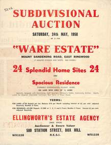
Flyer, Subdivisional Auction Sale Brochure, Ware Estate, East Ringwood, Vic. - 1958
... Folded double-sided advertisement for auction of 24 home sites and existing residence on Saturday, 24th May, 1958, including locality map, subdivision layout, terms of sale, and summary of local facilities and services. ...Subdivision includes Mount Dandenong Road, Ware Crescent, Davey Drive, and Grey Road (later Grey Street). ...Timber residence included in the subdivision was formerly Ware Kindergarten Holiday Home. ...Folded double-sided advertisement for auction of 24 home sites and existing residence on Saturday, 24th May, 1958, including locality map, subdivision layout, terms of sale, and summary of local facilities and services. Additional plan of lots 28-33 dated 26/10/60 by Licensed Surveyor for Kirkpatrick & Webber, 225 Maroondah Highway Ringwood headed Plan of Subdivision of part of Crown Allotment 26A Parish of Ringwood.Subdivision includes Mount Dandenong Road, Ware Crescent, Davey Drive, and Grey Road (later Grey Street). Timber residence included in the subdivision was formerly Ware Kindergarten Holiday Home. (Agent) Ellingworth's Estate Agency, 580 Station Street, Box Hill - (Phone) WX1228. -
 Kew Historical Society Inc
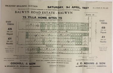
Plan - Subdivision Plan, Balwyn Road Estate, Balwyn (1937), 1937
... Historic subdivision in Balwyn, Victoria...Subdivision Plan of Balwyn Road Estate (Balwyn). ...Kew Historical Society Inc Kew Court House 188 High Street Kew melbourne Historic subdivision in Balwyn, Victoria subdivision plans - balwyn (Vic) Balwyn road estate - balwyn Inscriptions on individual lots by agent Subdivision Plan of Balwyn Road Estate (Balwyn). ...Historic subdivision in Balwyn, VictoriaSubdivision Plan of Balwyn Road Estate (Balwyn). Held in April 1937, the auction included 102 lots for sale in Yongala Avenue, Young Street, and Balwyn RoadInscriptions on individual lots by agentsubdivision plans - balwyn (vic), balwyn road estate - balwyn -
 Whitehorse Historical Society Inc.
Document, Certificate of Title, 1924, 1933
... Lot 277 subdivision 3051 Parish of Nunawading Vol.4945 Fol. 988875 1924., Certificate of Title: Myra Constance Agnes Robinson Lot 278 Subdivision 3051. ...Certificate of Title: Edmund Francis Shapley, Lot 277 subdivision 3051 Parish of Nunawading Vol.4945 Fol. 988875 1924., Certificate of Title: Myra Constance Agnes Robinson Lot 278 Subdivision 3051. ...Whitehorse Historical Society Inc. 2-10 Deep Creek Road Mitcham melbourne Lot 277 subdivision 3051 Parish of Nunawading Vol.4945 Fol. 988875 1924., Certificate of Title: Myra Constance Agnes Robinson Lot 278 Subdivision 3051. ...Certificate of Title: Edmund Francis ShapleyCertificate of Title: Edmund Francis Shapley, Lot 277 subdivision 3051 Parish of Nunawading Vol.4945 Fol. 988875 1924., Certificate of Title: Myra Constance Agnes Robinson Lot 278 Subdivision 3051. As above. Vol 4945 Fol,988876 1924, Rates - enforcement of charge 1933 & rates enforcement charge 1933.Certificate of Title: Edmund Francis Shapleyland titles, shire of nunawading, shire of blackburn, mitcham, shapley, edmund francis, robinson, myra constance agnes, alfred street blackburn -
Whitehorse Historical Society Inc.
Map, Gill's Springfield Road Estate, 1950?
... Copied by agent from lodged plan of subdivision...Plan of subdivision for Gill's Springfield Road Estate, former orchard, 16 lots. ...Copied by agent from lodged plan of subdivision Land Subdivision Norway Avenue Blackburn Springfield Road Blackburn Beverley Crescent Blackburn Kevin Avenue Blackburn Kerr Street Blackburn Bordeaux Avenue Blackburn Gill's Estate Orchards Spencer Jackson Plan of subdivision for Gill's Springfield Road Estate, former orchard, 16 lots. ...Plan of subdivision for Gill's Springfield Road Estate, former orchard, 16 lots.Plan of subdivision for Gill's Springfield Road Estate, former orchard, 16 lots. Reprinted by Real Estate Agent, Spencer Jackson.Plan of subdivision for Gill's Springfield Road Estate, former orchard, 16 lots. land subdivision, norway avenue, blackburn, springfield road, blackburn, beverley crescent, blackburn, kevin avenue, blackburn, kerr street, blackburn, bordeaux avenue, blackburn, gill's estate, orchards, spencer jackson -
 Ringwood and District Historical Society
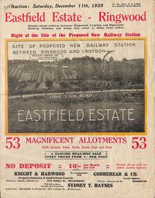
Flyer, Subdivisional Land Auction Sale Brochure, Eastfield Estate, Ringwood, Vic. - 1920
... Bi-folded double sided land advertisement for subdivision auction on Saturday, December 11th, 1920, for Eastfield Estate with location map and summary of local facilities and services....Subdivision includes Croydon South streets - Eastfield Road, Long View Road, The Mount, and Pleasant Rise. ...Ringwood and District Historical Society 125A Warrandyte Road Ringwood North melbourne Subdivision includes Croydon South streets - Eastfield Road, Long View Road, The Mount, and Pleasant Rise. ...Bi-folded double sided land advertisement for subdivision auction on Saturday, December 11th, 1920, for Eastfield Estate with location map and summary of local facilities and services.Subdivision includes Croydon South streets - Eastfield Road, Long View Road, The Mount, and Pleasant Rise. Local Agent - Godbehear & Co, Phone Ringwood 49. -
 Ringwood and District Historical Society
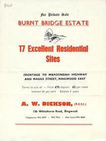
Flyer, Land Sale Brochure, Burnt Bridge Estate, Ringwood East/Croydon, Vic. - circa 1959
... Bi-folded single sheet with black and red print both sides including subdivision features and local facilities...Subdivision layout includes Marcus Road, Maggs Street and Maroondah Highway Croydon/Ringwood East. ...Ringwood and District Historical Society 125A Warrandyte Road Ringwood North melbourne Subdivision layout includes Marcus Road, Maggs Street and Maroondah Highway Croydon/Ringwood East. ...Bi-folded single sheet with black and red print both sides including subdivision features and local facilitiesSubdivision layout includes Marcus Road, Maggs Street and Maroondah Highway Croydon/Ringwood East. (Agent) A.W. Dickson, 136 Whitehorse Road, Ringwood, Telephones WU 6007, WU 7016, after hours WU 6868. -
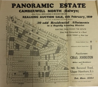 Kew Historical Society Inc
Plan - Subdivision Plan, Panoramic Estate, Camberwell North (Balwyn), 1939, 1939
... Subdivision plan advertised as the Panoramic Estate, Balwyn, showing lots for sale in the following streets: Bulleen Road, Macedon Avenue, The Moor, Sunburst Avenue, Doncaster Road, Fortuna Avenue, Longview Road, The Nook, and Touring Avenue....Single page subdivision plan of the Panoramic Estate in Camberwell North (Balwyn); offered for sale in 1939...Kew Historical Society Inc Kew Court House 188 High Street Kew melbourne Subdivision plan advertised as the Panoramic Estate, Balwyn, showing lots for sale in the following streets: Bulleen Road, Macedon Avenue, The Moor, Sunburst Avenue, Doncaster Road, Fortuna Avenue, Longview Road, The Nook, and Touring Avenue. subdivision plans - balwyn (vic) panoramic estate - camberwell north - balwyn (vic) Nil Single page subdivision plan of the Panoramic Estate in Camberwell North (Balwyn); offered for sale in 1939 Panoramic Estate, Camberwell North (Balwyn), 1939 Plan Subdivision Plan ...Subdivision plan advertised as the Panoramic Estate, Balwyn, showing lots for sale in the following streets: Bulleen Road, Macedon Avenue, The Moor, Sunburst Avenue, Doncaster Road, Fortuna Avenue, Longview Road, The Nook, and Touring Avenue.Single page subdivision plan of the Panoramic Estate in Camberwell North (Balwyn); offered for sale in 1939Nilsubdivision plans - balwyn (vic), panoramic estate - camberwell north - balwyn (vic) -
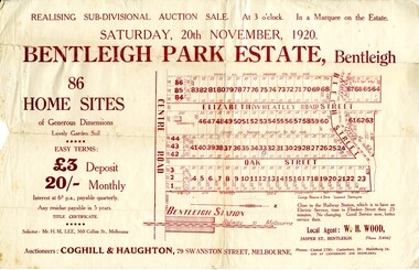 City of Kingston
Pamphlet - Colour, W. H. Wood Estate Agent, Realising sub-divisional auction sale Bentleigh Park Estate, Bentleigh, 1920
... Sales plan for land in the suburb of Bentleigh, bounded by Centre Road, and incorporating subdivisions on either side of Elizabeth Street (Wheatley Road), Oak Street and Beech Street....Hand drawn in grey pencil: a small square on subdivision 33 Hand drawn in grey pencil: a small square incorporating a cross on subdivision 24 Hand written in black ink on reverse: Bentleigh Park / Estate / Ward late Andersons...Land sales estate Bentleigh Hand drawn in grey pencil: a small square on subdivision 33 Hand drawn in grey pencil: a small square incorporating a cross on subdivision 24 Hand written in black ink on reverse: Bentleigh Park / Estate / Ward late Andersons Colour pamphlet advertising a realising sub-divisional auction sale of the Bentleigh Park Estate, Bentleigh. ...Sales plan for land in the suburb of Bentleigh, bounded by Centre Road, and incorporating subdivisions on either side of Elizabeth Street (Wheatley Road), Oak Street and Beech Street.The developing urban area of Bentleigh within the City of Kingston. This land sale pamphlet illustrates the subdivision of land within the municipality and the changing demographic of the district as new houses are constructed close to infrastructure.Colour pamphlet advertising a realising sub-divisional auction sale of the Bentleigh Park Estate, Bentleigh. Incorporates a map of the estate bordered by Centre Road, and including Elizabeth Street (Wheatley Road), Oak Street and Beech Street.Hand drawn in grey pencil: a small square on subdivision 33 Hand drawn in grey pencil: a small square incorporating a cross on subdivision 24 Hand written in black ink on reverse: Bentleigh Park / Estate / Ward late Andersonsland sales, estate, bentleigh -
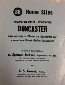 Kew Historical Society Inc
Plan - Subdivision Plan, New Haven Estate, Doncaster
... Subdivision of 86 home sites in Doncaster....Undated subdivision plan for 86 home sites in the New Haven Estate in Doncaster. ...Kew Historical Society Inc Kew Court House 188 High Street Kew melbourne Subdivision of 86 home sites in Doncaster. New Haven Estate - Doncaster (vic) subdivision plans - doncaster (vic) Nil Undated subdivision plan for 86 home sites in the New Haven Estate in Doncaster. ...Subdivision of 86 home sites in Doncaster.Undated subdivision plan for 86 home sites in the New Haven Estate in Doncaster. The 2-sided plan has a locality plan on the reverse.The land for sale would appear to be in George StreetNilnew haven estate - doncaster (vic), subdivision plans - doncaster (vic) -
Whitehorse Historical Society Inc.
Letter - Correspondence, Goodwin Family, 17/10/1989 12:00:00 AM
... Accompanying copies of subdivisions in the vicinity of Blackburn Station, 'Blackburn Park'....Letter from Patricia Turner to Judith Fry regarding history of George Augustus Goodwin and his family, accompanying copies of subdivisions in the vicinity of Blackburn Station, 'Blackburn Park'....Whitehorse Historical Society Inc. 2-10 Deep Creek Road Mitcham melbourne Accompanying copies of subdivisions in the vicinity of Blackburn Station, 'Blackburn Park'. ...Letter from Patricia Turner to Judith Fry regarding history of George Augustus Goodwin and his family.Letter from Patricia Turner to Judith Fry regarding history of George Augustus Goodwin and his family, accompanying copies of subdivisions in the vicinity of Blackburn Station, 'Blackburn Park'.Letter from Patricia Turner to Judith Fry regarding history of George Augustus Goodwin and his family. blackburn park, goodwin, george augustus, railway road, blackburn, station street, blackburn, queen street, blackburn, albert street, blackburn, chapel street, blackburn, mary street, blackburn, george street, blackburn, cottage street, blackburn -
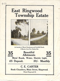 Ringwood and District Historical Society
Flyer, Subdivisional Land Sale Brochure, East Ringwood Township Estate, Vic. - 1923
... Bi-folded double sided land subdivision sale advertisement with location map and summary of local facilities and services. ...Subdivision includes Mount Dandenong Road, Grey Street, and Eastfield Road. ...Ringwood and District Historical Society 125A Warrandyte Road Ringwood North melbourne Subdivision includes Mount Dandenong Road, Grey Street, and Eastfield Road. ...Bi-folded double sided land subdivision sale advertisement with location map and summary of local facilities and services. Includes two additional images of allotment plan with subsequent handwritten notations.Subdivision includes Mount Dandenong Road, Grey Street, and Eastfield Road. Agent - C.E. Carter, Bank Chambers, Main Street, Ringwood. Phone Ringwood 24. -
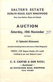 Ringwood and District Historical Society
Flyer, Land Sale Auction Brochure, Salter's Estate, East Ringwood, Vic. - 1956
... Folded single page advertising auction of allotments on Saturday, 10th November (1956), including layout of subdivision and terms of sale....Subdivision includes Railway Avenue, Nicholson Street, Althol Grove (later Morcom Avenue), Illoura Avenue, Tweed Street, Merry Street, and Dublin Road. ...Ringwood and District Historical Society 125A Warrandyte Road Ringwood North melbourne Subdivision includes Railway Avenue, Nicholson Street, Althol Grove (later Morcom Avenue), Illoura Avenue, Tweed Street, Merry Street, and Dublin Road. ...Folded single page advertising auction of allotments on Saturday, 10th November (1956), including layout of subdivision and terms of sale.Subdivision includes Railway Avenue, Nicholson Street, Althol Grove (later Morcom Avenue), Illoura Avenue, Tweed Street, Merry Street, and Dublin Road. (Agent) C.E. Carter & Son R.E.S.I., Auctioneer, 126 Whitehorse Road, Ringwood, Phone WU6024. -
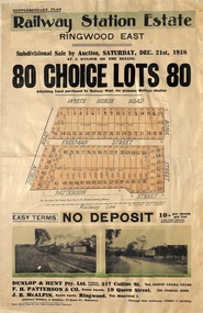 Ringwood and District Historical Society
Flyer, Subdivisional Auction Sale Brochure, Railway Station Estate, Ringwood East, Vic. - 1918
... Advertisement for subdivisional auction sale of 80 residential allotments on Saturday, 21st December, 1918, including terms of sale, subdivision layout, and nearby location photographs....Subdivision includes Mount Dandenong Road (incorrectly shown as White Horse Road), Dublin Road, Freeman Street, Bona Street, and Patterson Street. ...Ringwood and District Historical Society 125A Warrandyte Road Ringwood North melbourne Subdivision includes Mount Dandenong Road (incorrectly shown as White Horse Road), Dublin Road, Freeman Street, Bona Street, and Patterson Street. ...Advertisement for subdivisional auction sale of 80 residential allotments on Saturday, 21st December, 1918, including terms of sale, subdivision layout, and nearby location photographs.Subdivision includes Mount Dandenong Road (incorrectly shown as White Horse Road), Dublin Road, Freeman Street, Bona Street, and Patterson Street. Local Agent - J.B. McAlpin, Telephone Ringwood 7. -
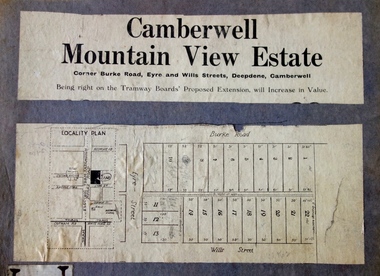 Kew Historical Society Inc
Plan - Subdivision Plan, Camberwell Mountain View Estate, 1923
... The Kew Historical Society collection includes almost 100 subdivision plans pertaining to suburbs of the City of Melbourne. ...The so-called Camberwell Mountain View Estate was a subdivision on ‘the corner [of] Burke Road, Eyre and Wills Streets, Deepdene’. ...Camberwell Mountain View Estate Plan Subdivision Plan J R Mathers & McMillan ...The Kew Historical Society collection includes almost 100 subdivision plans pertaining to suburbs of the City of Melbourne. Most of these are of Kew, Kew East or Studley Park, although a smaller number are plans of Camberwell, Deepdene, Balwyn and Hawthorn. It is believed that the majority of the plans were gifted to the Society by persons connected with the real estate firm - J. R. Mathers and McMillan, 136 Cotham Road, Kew. The Plans in the collection are rarely in pristine form, being working plans on which the agent would write notes and record lots sold and the prices of these. The subdivision plans are historically significant examples of the growth of urban Melbourne from the beginning of the 20th Century up until the 1980s. A number of the plans are double-sided and often include a photograph on the reverse. A number of the latter are by noted photographers such as J.E. Barnes.The so-called Camberwell Mountain View Estate was a subdivision on ‘the corner [of] Burke Road, Eyre and Wills Streets, Deepdene’. The Estate was not the first attempt to subdivide this land holding. In 1884, 1888 and 1894 the Belmore Park subdivision proposed 18 allotments for this parcel of land. The final stages of the Belmore Park subdivision occurred during the Depression of the 1890s. Apart from perhaps one block facing Burke Road, which is unnumbered in the Mountain View Estate subdivision, the rest must have remained unsold. The later subdivision would redraw the original 18 allotments, creating 22 new lots. In the Locality Plan on the left side of the subdivision plan, Deepdene Station, which formed part of the Outer Circle Railway is represented, as is the location of Deepdene Primary School. A selling point was the proposed extension of the Burke Road tram beyond its terminus at Cotham Road. The extension did not eventuate.subdivision plans - camberwell, mountain view estate -
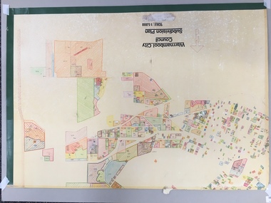 Warrnambool and District Historical Society Inc.
Map, Plans (5) showing Subdivisions of Warrnambool, 1989
... These plans have been drawn by Steve Hester for the Warrnambool City Council to illustrate the allotments in Warrnambool concerned with the subdivisions of 1989. The streets have not been named but there is an indication of the area with the identification of known buildings (eg Hospital) and the plan numbers of each allotment is clearly marked. ...‘Subdivision Plan, Reference Guide, Steve Hester, Oct. 1989’. ...Plans (5) showing Subdivisions of Warrnambool Map ...These plans have been drawn by Steve Hester for the Warrnambool City Council to illustrate the allotments in Warrnambool concerned with the subdivisions of 1989. The streets have not been named but there is an indication of the area with the identification of known buildings (eg Hospital) and the plan numbers of each allotment is clearly marked. These numbers corresponded to the plan numbers registered in card files and ledgers in the Warrnambool City Council offices. The scale of the plans was 1 to 5000. These plans are of considerable interest because they show Warrnambool street subdivisions of 1989 in illustrative form. They show how information was collated in the late 1980s before the widespread use of computer digital means to describe and store information.These are five hand-drawn sheets showing plans of sub-divisions in Warrnambool streets in 1989 (Warrnambool City Council material). The plans are multi-coloured (crayons) and show allotments with plan numbers. The first plan has much of the material torn off but the location is known to be in the Russells Creek area. Some of the green tape around the edges is missing. Plans two to five are almost intact and are bound with green tape. Plan Two- Industrial Estate of West Warrnambool; Plan Three – Hospital/Merrivale/ Lake Pertobe areas; Plan Four – North Warrnambool, Wollaston/Brierly areas; Plan Five – Flaxman Street area. ‘Subdivision Plan, Reference Guide, Steve Hester, Oct. 1989’. warrnambool street subdivisions, steve hester, history -
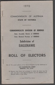 Bendigo Historical Society Inc.
Administrative record - Electoral Roll, 1915
... Electoral Roll for the Commonwealth Division of Bendigo, State Assembly District of Bendigo, and State Electoral Province of Bendigo Subdivision of Eaglehawk for 1970 (made up to 2nd January 1970). ...Includes Name, Address, Occupation and gender for thirteen subdivisions. Assembled and bound with staples, with a light grey card cover....Name, Address, Occupation and gender for thirteen subdivisions. Electoral rolls were published by each state during election years. ...Electoral Roll for the Commonwealth Division of Bendigo, State Assembly District of Bendigo, and State Electoral Province of Bendigo Subdivision of Eaglehawk for 1970 (made up to 2nd January 1970). Voting registers, or electoral rolls, are a census of those who were eligible to vote. They are valuable because a country-wide census was not taken until 1911. Early electoral rolls give an individual name, residence, status of property occupation/ownership, and the rate value of the property. Electoral Rolls are arranged by electoral district and subdistrict. Name, Address, Occupation and gender for thirteen subdivisions. Electoral rolls were published by each state during election years. Electoral Roll for the Commonwealth Division of Bendigo, State Assembly District of Bendigo, and State Electoral Province of Bendigo, Subdivision of Eaglehawk for 1970 (made up to 2nd January 1970). Includes Name, Address, Occupation and gender for thirteen subdivisions. Assembled and bound with staples, with a light grey card cover..electoral rolls, voting in bendigo -
 Ringwood and District Historical Society
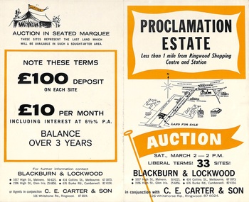
Flyer, Land Auction Sale Brochure, Proclamation Estate, Ringwood, Victoria - circa 1963
... Land sale auction advertisement - Proclamation Estate, Ringwood, with map of subdivision and summary of local features and services. ...Subdivision plan includes Maidstone Street, Stanhope Court, Wrights Court, and Watirna Road. ...Ringwood and District Historical Society 125A Warrandyte Road Ringwood North melbourne Subdivision plan includes Maidstone Street, Stanhope Court, Wrights Court, and Watirna Road. ...Land sale auction advertisement - Proclamation Estate, Ringwood, with map of subdivision and summary of local features and services. Auction date, Saturday, March 2, (1963?), at 2pm.Subdivision plan includes Maidstone Street, Stanhope Court, Wrights Court, and Watirna Road. (Agents) Blackburn & Lockwood in conjunction with C.E. Carter & Son, 126 Whitehorse Road, Ringwood (Phone) 87 6024. -
 Ringwood and District Historical Society
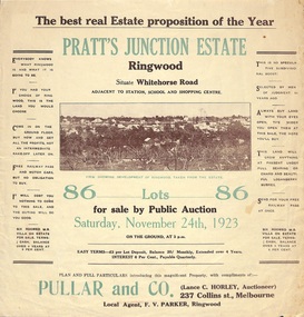
Flyer, Brochure for Land Sale By Public Auction, Pratt's Junction Estate, Ringwood, Victoria - 1923
... Folded double-sided brochure advertising 86 residential lots for sale by Public Auction at 3pm, Saturday, November 24th, 1923, with town photographs, map of subdivision and summary of local features and services. ...Subdivision plan includes Whitehorse Road, Oliver Street, Georges Road, Junction Street, and six room weatherboard villa for sale. ...Ringwood and District Historical Society 125A Warrandyte Road Ringwood North melbourne Subdivision plan includes Whitehorse Road, Oliver Street, Georges Road, Junction Street, and six room weatherboard villa for sale. ...Folded double-sided brochure advertising 86 residential lots for sale by Public Auction at 3pm, Saturday, November 24th, 1923, with town photographs, map of subdivision and summary of local features and services. Subdivision plan includes Whitehorse Road, Oliver Street, Georges Road, Junction Street, and six room weatherboard villa for sale. Local Agent - F.V. Parker, Ringwood. -
 Kew Historical Society Inc
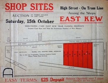
Plan - Subdivision Plan, Shop Sites, East Kew, c.1927
... Subdivision plans are historically important documents used as evidence of the growth of suburbs in Australia. ...This is one of a small number of subdivision plans for commercial property in the collection. ...Shop Sites, East Kew Plan Subdivision Plan J R Mathers & McMillan ...Subdivision plans are historically important documents used as evidence of the growth of suburbs in Australia. They frequently provide information about when the land was sold on which a built structure was subsequently constructed as well as evidence relating to surveyors and real estate and financial agents. The numerous subdivision plans in the Kew Historical Society's collection represent working documents, ranging from the initial sketches made in planning a subdivision to printed plans on which auctioneers or agents listed the prices for which individual lots were sold. In a number of cases, the reverse of a subdivision plan in the collection includes a photograph of a house that was also for sale by the agent. These photographs provide significant heritage information relating house design and decoration, fencing and household gardens.This is one of a small number of subdivision plans for commercial property in the collection. The subdivision proposed to create six shop sites in High Street between the Harp of Erin and Station Street. The plan shows this stretch of High Street, East Kew already lined with shops that include the hotel on the corner, the new State Savings Bank, a dentist’s surgery and Lambert’s Store. The High Street Tram was to reach Burke Road in 1925, so the proposed subdivision must postdate that event, and the opening of the Bank in 1926.subdivision plans - east kew, high street - east kew -
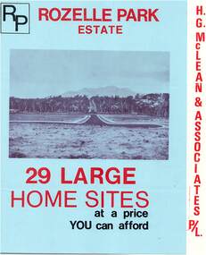 Ringwood and District Historical Society
Flyer, Subdivisional Land Sale Brochure, Rozelle Park Estate, Ringwood East, Vic. - circa 1968
... Folded land subdivision sale advertisement for 29 home sites, with location map and summary of local facilities and services. ...Subdivision includes Wingate Avenue and Rozelle Avenue, Ringwood East. ...Ringwood and District Historical Society 125A Warrandyte Road Ringwood North melbourne Subdivision includes Wingate Avenue and Rozelle Avenue, Ringwood East. ...Folded land subdivision sale advertisement for 29 home sites, with location map and summary of local facilities and services. Separate price list leaflet enclosed with terms of sale.Subdivision includes Wingate Avenue and Rozelle Avenue, Ringwood East. Agent - H.G. McLean & Associates Pty. Ltd., 166 Canterbury Road, Heathmont. Phone 870 3422 A/H 870 5879. -
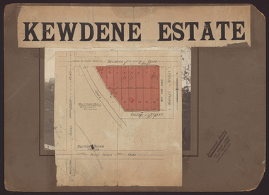 Kew Historical Society Inc
Plan - Subdivision Plan, Kewdene Estate, 1937-1939
... Pru Sanderson, in her groundbreaking ‘City of Kew Urban Conservation Study : Volume 2 - Development History’ (1988), summarised the periods of urban development and subdivisions of land in Kew. The periods that she identified included 1845-1880, 1880-1893, 1893-1921, 1921-1933, 1933-1943, and Post-War Development. ...The advertisement for the ‘Kewdene Estate’ subdivision is pasted over a photograph of a property for sale. ...On the other side of the subdivision [Glass] Creek is noted. The subdivision plan also shows part of the Outer Circle Railway and Deepdene Railway Station. ...Pru Sanderson, in her groundbreaking ‘City of Kew Urban Conservation Study : Volume 2 - Development History’ (1988), summarised the periods of urban development and subdivisions of land in Kew. The periods that she identified included 1845-1880, 1880-1893, 1893-1921, 1921-1933, 1933-1943, and Post-War Development. These periods were selected as they represented periods of rapid growth or decline in urban development. An obvious starting point for Sanderson’s groupings involved population growth and the associated economic cycles. These cycles also highlighted urban expansion onto land that was predominantly rural, although in other cases it represented the decline and breakup of large estates. A number of the plans in the Kew Historical Society’s collection can also be found in other collections, such as those of the State Library of Victoria and the Boroondara Library Service. A number are however unique to the collection.The Kew Historical Society collection includes almost 100 subdivision plans pertaining to suburbs of the City of Melbourne. Most of these are of Kew, Kew East or Studley Park, although a smaller number are plans of Camberwell, Deepdene, Balwyn and Hawthorn. It is believed that the majority of the plans were gifted to the Society by persons connected with the real estate firm - J. R. Mathers & McMillan, 136 Cotham Road, Kew. The Plans in the collection are rarely in pristine form, being working plans on which the agent would write notes and record lots sold and the prices of these. The subdivision plans are historically significant examples of the growth of urban Melbourne from the beginning of the 20th Century up until the 1980s. A number of the plans are double-sided and often include a photograph on the reverse. The advertisement for the ‘Kewdene Estate’ subdivision is pasted over a photograph of a property for sale. This is typical of the reuse of promotional materials in the period during, and subsequent to World War I. The subdivision included 14 lots bordered by Belmore Road, Birtles Street and Giles Street. On the other side of the subdivision [Glass] Creek is noted. The subdivision plan also shows part of the Outer Circle Railway and Deepdene Railway Station.subdivision plans - east kew, kewdene estate, belmore road -- kew east (vic.), giles street -- kew east (vic.) -
Whitehorse Historical Society Inc.
Map, Springfield Road, Blackburn, 1924
... Passed by MMBW 24 May 1924. Subdivision not implemented. Originally owned by Leonard Sherwin Bayley, then by Edward Henry Pearce, then by Ron Pearce. ...Plan of subdivision, parts of Crown Portions 73 and 74, parish of Nunawading, County of Bourke. ...Plan of subdivision, parts of Crown Portions 73 and 74, parish of Nunawading, County of Bourke. ...Plan of subdivision, parts of Crown Portions 73 and 74, parish of Nunawading, County of Bourke.Plan of subdivision, parts of Crown Portions 73 and 74, parish of Nunawading, County of Bourke. Passed by MMBW 24 May 1924. Subdivision not implemented. Originally owned by Leonard Sherwin Bayley, then by Edward Henry Pearce, then by Ron Pearce. Part compulsorily acquired as site for Blackburn High School. With historical notes by Ron Pearce.Plan of subdivision, parts of Crown Portions 73 and 74, parish of Nunawading, County of Bourke. bayley, leonard sherwin, pearce, edward h, pearce, ronald harry, orchards, blackburn high school, north blackburn square shopping centre -
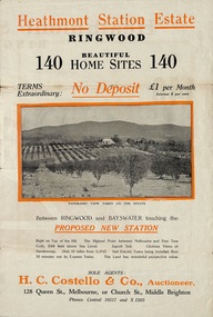 Ringwood and District Historical Society
Flyer, Land Sale Brochure, Heathmont Station Estate, Ringwood, Vic. - circa 1925
... Bi-fold advertisement for sale of retail and residential sites, including panoramic and other photographs, map, and summary of subdivision features and local facilities. ...Subdivision includes Canterbury Road, Station Street (later Wainui Avenue), Lisgoold Street, Viviani Crescent, and Balfour Avenue. ...The commissioners are alive to the necessity for assisting to settle the picturesque districts between Box Hill and Gembrook. Subdivision includes Canterbury Road, Station Street (later Wainui Avenue), Lisgoold Street, Viviani Crescent, and Balfour Avenue. ...Extract of "Herald" 2/2/22: The intention of the Railway Commissioners is to electrify the line to the Gully as soon as convenient, and with greater frequency of service many persons settled, and settling, in the district will be benefited. There is a scheme which may be launched that will allow for an express service of fast trains to the Gully. The commissioners are alive to the necessity for assisting to settle the picturesque districts between Box Hill and Gembrook.Bi-fold advertisement for sale of retail and residential sites, including panoramic and other photographs, map, and summary of subdivision features and local facilities. Subdivision includes Canterbury Road, Station Street (later Wainui Avenue), Lisgoold Street, Viviani Crescent, and Balfour Avenue. Agent - H.C. Costello & Co., Auctioneer, 128 Queen Street, Melbourne, or Church Street, Middle Brighton. Phones: Central 10517 and X1205. -
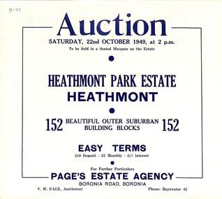 Ringwood and District Historical Society
Flyer, Land Auction Sale Brochure, Heathmont Park Estate, Heathmont, Vic. - 1949
... Double sided multi-fold advertisement for auction sale of residential allotments, including summary of subdivision features and local facilities. Auction on Saturday, 22nd October, 1949, at 2 p.m....Subdivision includes Great Ryrie Street, Erica Crescent, Neil Street, Frances Street, Viviani Crescent, and Canterbury Road. ...Ringwood and District Historical Society 125A Warrandyte Road Ringwood North melbourne Subdivision includes Great Ryrie Street, Erica Crescent, Neil Street, Frances Street, Viviani Crescent, and Canterbury Road. ...Double sided multi-fold advertisement for auction sale of residential allotments, including summary of subdivision features and local facilities. Auction on Saturday, 22nd October, 1949, at 2 p.m.Subdivision includes Great Ryrie Street, Erica Crescent, Neil Street, Frances Street, Viviani Crescent, and Canterbury Road. Agent - Page's Estate Agency, Boronia Road, Boronia. Phone Bayswater 42. -
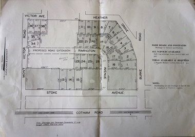 Kew Historical Society Inc
Plan, F R Simms & Son, Land for Private Sale: Cnr Victor Avenue and Mont Victor Road, Kew, 1950-1960
... Previous lots in the subdivision had bordered Burke Road, Rimington Avenue, Heather Grove, and Stoke Avenue. ...Subdivision plan advertising five superb home sites among lots in Burke Road, Stoke Avenue, Victor Avenue, Mont Victor Road and Heather Grove....Previous lots in the subdivision had bordered Burke Road, Rimington Avenue, Heather Grove, and Stoke Avenue. ...George Rimington established The Parkhill Nursery in 1877. By 1910, it was more commonly known as Rimington’s Nurseries and well known for its sale of violets. After World War II, Rimington’s Nurseries were gradually subdivided and sold. The 38 allotments were released in sections, including lots 34 to 36 on the corner of Mont Victor Road and Victor Avenue. Previous lots in the subdivision had bordered Burke Road, Rimington Avenue, Heather Grove, and Stoke Avenue. The selling point as it had been in comparable estates for a century were the proximity to transport, schools and churches, as well as the high location and excellent views. The subdivision plan shows most of the lots in the entire subdivision: 1-11, 13-26, and 34-38. Presumably, lot 12 and lots 27-33 were still to be released.Subdivision plans are historically important documents used as evidence of the growth of suburbs in Australia. They frequently provide information about when the land was sold on which a built structure was subsequently constructed as well as evidence relating to surveyors and real estate and financial agents. The numerous subdivision plans in the Kew Historical Society's collection represent working documents, ranging from the initial sketches made in planning a subdivision to printed plans on which auctioneers or agents listed the prices for which individual lots were sold. In a number of cases, the reverse of a subdivision plan in the collection includes a photograph of a house that was also for sale by the agent. These photographs provide significant heritage information relating house design and decoration, fencing and household gardens.Subdivision plan advertising five superb home sites among lots in Burke Road, Stoke Avenue, Victor Avenue, Mont Victor Road and Heather Grove.subdivision plans - kew, rimington avenue -- kew (vic.), heather grove -- kew (vic), stoke avenue -- kew (vic.), burke road -- kew (vic.), mont victor road -- kew (vic.) -
 Wonga Park Community Cottage History Group
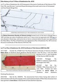
Document - Title History, Title History of Lot 71 PS 4315 Wonga Park
... The history of Lot 71 on Plan of Subdivision No. 4315 Wonga Park (area 50 acres 1 rood and 29 perches) starts in 1902 when the subdivision was registered by the Mutual Assurance Society of Victoria Limited then transferred to Millie Glass, Married Woman of Glenferrie. ...Archive file for Lot 71 on Plan of Subdivision No. 4315 Wonga Park, containing title history documents and research. ...Wonga Park Community Cottage History Group Unit 1, 9 – 13 Old Yarra Road Wonga Park melbourne The history of Lot 71 on Plan of Subdivision No. 4315 Wonga Park (area 50 acres 1 rood and 29 perches) starts in 1902 when the subdivision was registered by the Mutual Assurance Society of Victoria Limited then transferred to Millie Glass, Married Woman of Glenferrie. ...The history of Lot 71 on Plan of Subdivision No. 4315 Wonga Park (area 50 acres 1 rood and 29 perches) starts in 1902 when the subdivision was registered by the Mutual Assurance Society of Victoria Limited then transferred to Millie Glass, Married Woman of Glenferrie. The history of registered owners who have a connection with the Lot include Harris Glass, Janie Glass, Annie Glass, Charlotte Soloman, Barnett Glass, Sydney Charles Mackie, Arno Herbert Neuparth and Valerie June Neuparth, inter alia.Archive file for Lot 71 on Plan of Subdivision No. 4315 Wonga Park, containing title history documents and research. Documents include Certificates of Title Volume 4390 Folio 992, Volume 5924 Folio 711, Volume 8723 Folio 836, Volume 8995 Folio 834, Volume 9016 Folio 994, Volume 10006 Folio 334 and Plan of Subdivision No. 3039575. -
 Ringwood and District Historical Society
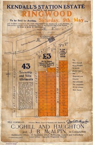
Flyer, Auction Sale Advertisements - Kendall's Station Estate, Ringwood, Victoria - 1914
... Advertisements for auction sale on Saturday, 9th May (1914) 43 township and villa allotments directly opposite the railway station, showing terms of sale and subdivision layout. Un-named newspaper clipping advertising this auction also attached....Subdivision includes James Street and William Street (later Kendall Street), Ringwood. ...Ringwood and District Historical Society 125A Warrandyte Road Ringwood North melbourne Subdivision includes James Street and William Street (later Kendall Street), Ringwood. ...Advertisements for auction sale on Saturday, 9th May (1914) 43 township and villa allotments directly opposite the railway station, showing terms of sale and subdivision layout. Un-named newspaper clipping advertising this auction also attached.Subdivision includes James Street and William Street (later Kendall Street), Ringwood. Agents in conjunction - Coghill & Haughton and J.B. McAlpin. Sale by order of Mrs. E. Kendall. -
 Ringwood and District Historical Society
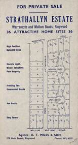
Flyer, Land Sale Advertisement - Strathallyn Estate, Ringwood, Victoria - circa 1950
... Advertisement for private sale of 36 home sites in the Warrandyte Road and Mullum Mullum Road area of Ringwood, with map showing layout of subdivision and summary of local features and services. ...Subdivision includes Warrandyte Road, Strathallyn Road, Norman Court, Lade Court, and Mullum Mullum Road. ...Ringwood and District Historical Society 125A Warrandyte Road Ringwood North melbourne Subdivision includes Warrandyte Road, Strathallyn Road, Norman Court, Lade Court, and Mullum Mullum Road. ...Advertisement for private sale of 36 home sites in the Warrandyte Road and Mullum Mullum Road area of Ringwood, with map showing layout of subdivision and summary of local features and services. Handwritten notation indicates May, 1950.Subdivision includes Warrandyte Road, Strathallyn Road, Norman Court, Lade Court, and Mullum Mullum Road. Agents: A.T. Miles & Son, 175 Main Street, Ringwood, Phone WU6215. -
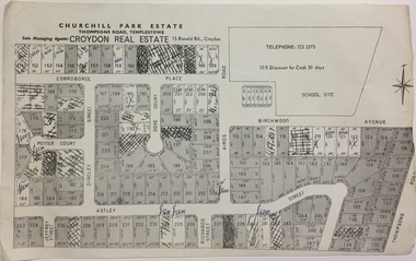 Kew Historical Society Inc
Plan - Subdivision Plan, Churchill Park Estate, Templestowe
... Historic subdivision plan of the Churchill Park Estate in Templestowe....Undated subdivision plan advertising the Churchill Park Estate inTemplestowe. ...Kew Historical Society Inc Kew Court House 188 High Street Kew melbourne Historic subdivision plan of the Churchill Park Estate in Templestowe. subdivision plans - templestowe (vic) churchill park estate - templestowe (vic) Annotations in ink on the plan by agent Undated subdivision plan advertising the Churchill Park Estate inTemplestowe. ...Historic subdivision plan of the Churchill Park Estate in Templestowe.Undated subdivision plan advertising the Churchill Park Estate inTemplestowe. Streets identified in the plan include: Corroboree Place, Astley Street, Jeffrey Street, Airds Road, Dove Court, Potter Court, Thompsons Road, Richards Street, and Birchwood Avenue.Annotations in ink on the plan by agentsubdivision plans - templestowe (vic), churchill park estate - templestowe (vic) -
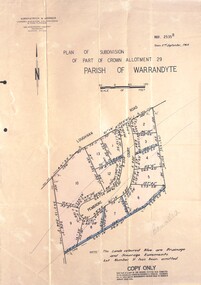 Ringwood and District Historical Society
Document - Folder, Pembroke Estate Subdivsion, Ringwood, Victoria - 1964
... Subdivision includes allotments on Pembroke Court off Loughnans Road, Ringwood....Folder covernote by Richard Carter - Carter Real Estate - "Vendor - Dale, Plan of Subdivision 68868, sold 23 July 1966."...Subdivision includes allotments on Pembroke Court off Loughnans Road, Ringwood. ...Manilla folder containing certified copy of Plan of Subdivision dated 2nd September, 1964 - Part of Crown Allotment 29 Parish of Warrandyte, and separate A4 size copy of plan with handwritten 1966 pricing notations. Subdivision includes allotments on Pembroke Court off Loughnans Road, Ringwood.Surveyors - Kirkpatrick & Webber, Civil Engineers & Town Planners, 225 Maroondah Highway, Ringwood, Telephone 8700321. Agents - C.E. Carter & Son RESI., 126 Whitehorse Road, Ringwood (Phone) 87-6024, 87-6830, 870-2519. Folder covernote by Richard Carter - Carter Real Estate - "Vendor - Dale, Plan of Subdivision 68868, sold 23 July 1966."