Showing 685 items
matching victorian park
-
 Puffing Billy Railway
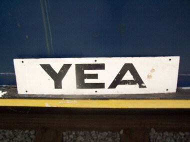
Station Sign - Yea
Station Sign - Yea Yea Station Opened 16 November 1883 Closed 8 November 1978 Yea is a former railway station in Yea, Victoria, Australia. The tracks have been removed and the reserve has been turned into The Yea Railway Park consisting of the historic railway station and eleven acres of parkland. It has a picnic shelter, barbecue, toilets, playground, skatepark, walking track, community reserve and includes Rotary Park. The station building houses Blackthorn Textiles (a privately run craft shop). Also on the site are the former goods sheds which are available for hire for varied functions. The Yea Country Market is held in the park on the first Saturday of each month and local artists hold an exhibition and sale in the goods sheds each Easter. The site is listed on the Victorian Heritage Register ref: https://en.wikipedia.org/wiki/Yea_railway_station photo at http://vhd.heritagecouncil.vic.gov.au/vhd-images/places/000/078/092.jpg Historic - Victorian Railways Station sign used at Yea StationStation Sign - Yea Metal rectangle Station Name Sign with white enamel back ground and black lettersYeapuffing billy, station sign, yea station -
 Ruyton Girls' School
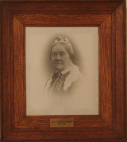
Photograph - Photographic Portrait, Mrs Charlotte Anderson
Mrs Charlotte Anderson was born Charlotte Eliza Alsop in England in 1838 and arrived in Australia in 1848. She married lawyer James Anderson in 1864, and in the year of his death in 1878 she became the founding owner-Principal of Ruyton Girls' School, Kew. Mrs Anderson operated Ruyton initially in her own home of 63 Bulleen Road, Kew (now 63 High Street South). According to Ruyton histories, Mrs Anderson is said to have begun the school with her own two sons, four daughters and some of her Alsop nieces and nephews who resided in Kew. Around the time of the addition of Maud King, the first student outside the family, the school changed to a 'Ladies College', and the boys were sent elsewhere for their education. By late 1881 Mrs Anderson began using the name 'Ruyton' for the school, in honour of a connection to Ruyton-XI-Towns, Shropshire, England where her great-grandfather had been vicar and where she was baptised. In 1882 Mrs Anderson moved the School to Edgecomb in Studley Park Road from 1882-1888. The larger premises enabled her to begin accepting boarding students from 1882. She retired due to ill health and sold the school to her friend Miss Eliza Bromby. Mrs Anderson lived at 'Bongamero', in the King Valley, Victoria until her death in 1906. She is buried in Boroondara Cemetery. One of Ruyton's four Houses, Anderson, is named for Charlotte Anderson. Artwork AC/0099 is a framed reproduction photograph of an original portrait of Mrs Anderson, c.1900-1906. The location and date of the original photograph is unknown, but may be held among Ruyton papers at the State Library of Victoria (MS 12079). The reproduction was probably created to be part of the gallery of Principals and significant people for the Conference/Boardroom, Henty House.A framed, black & white reproduction of a photographic portrait. The portrait shows the head and shoulders of a middle aged woman wearing Victorian-era clothing including a dark ribbon tied around her collar. She wears a lace cap on her head, and the cap's tail is draped around her shoulders. The woman's body is partially turned away from the camera, while her face is turned toward the camera. Plaque on frame: "Mrs Charlotte Anderson/ 1878-1888"charlotte anderson, ruyton, ruyton girls' school, kew (vic), bulleen road, high street south, studley park road, edgecomb, woman, school, teacher, principal, anderson, reproduction, 1990s -
 Victorian Aboriginal Corporation for Languages
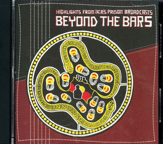
Audio CD, Radio 3CR, Beyond the bars : highlights from 3CR's prison broadcasts : NAIDOC Week 2004, 2004
The Beyond the Bars broadcasts are the culmination of 3CR's out + blak on air project. The project was produced with the support from the City of Melbourne, the Victorian Aboriginal Justice Agreement and the City of Yarra. This CD is an hour-long radio program of highlights from two live prison broadcasts. These broadcasts took place during NAIDOC Week 2004. The session includes interviews, songs, poems and messages from Indigenous inmates at Port Phillip Prison and the Dame Phyllis Frost Centre, Deer Park. The broadcasts were presented by 3CR broadcasters Lisa Bellear, Eleisha Jones, Gilla McGuinness, Johnny McGuinness, Ross Morgan, Lester Green, and Kutcha Edwards. Technical assistance by Greg Segal and Lotti Stein. Program coordination by Juliet Fox. Project coordination by Bree McKilligan.CDsocial justice, victorian prisons, naidoc, broadcasting, radio, 3cr, rehabilitation, dame phyllis frost centre, port phillip prison -
 Victorian Aboriginal Corporation for Languages
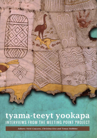
Book, Vicki Couzens, tyama-teeyt yookapa : interviews from the Meeting Point Project, 2014
This book is a collection of stories, reflections and hopes abuot Language revival in Australian Aboriginal communities, extracted from a series of interviews carried out during 2009-2010.B&w photographslanguage revival, interviews, indigenous language victoria, indigenous language nsw, parkes, gumbaynggirr, wiradjuri -
 Victorian Aboriginal Corporation for Languages
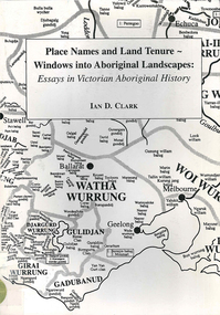
Book, Ian D Clark, Place names and land tenure : windows into Aboriginal landscapes : essays in Victorian Aboriginal history, 1998
This work is a collection of twelve essays that are concerned with place names, clan organisation and local and regional Aboriginal history.maps, document reproductionsdjab wurrung, ngengen wurrung, koroitgundidj, dhauwurud wurrung, djab wurrung, barababaraba, daung wurrung, taungurung, dja dja wurrung, jardwadjali, jodajoda, yorta yorta, nguri-illam wurrung, waywurru, koroit, buangor, mt eccles, mt napier, langi ghiran, grampians national park, massacres, clan organization, land tenure, george augustus robinson, samuel carter, aldo massola, alfred william howitt -
 Victorian Aboriginal Corporation for Languages
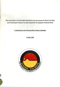
Book, Ian D Clark et al, The restoration of Jardwadjali and Djab wurrung names for rock art sites and landscape features in and around the Grampians National Park : a submission to the Victorian Place Names Committee, 1990
Lists each site and gives details.maps, word listsjardwadjali, djab wurrung, djabwurrung, rock art, grampians national park, gariwerd, major thomas l mitchell, aboriginal place names -
 Victorian Aboriginal Corporation for Languages
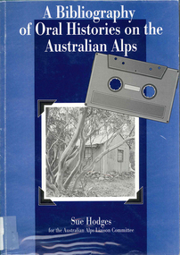
Book, Sue Hodges, A bibliography of oral histories on the Australian Alps, 1996
Covers 465 oral history interviews contained in a number of collections: - Kosciusko Huts Committee collection, Matthew Higgins collection, Peter Read collection, Ruth Lane collection, Sue Hodges collection, Tor and Jane Holth collection, Klaus Hueneke collection, Siobhan McHugh collection, National Parks and Wildlife Service collection, Stockman's Hall of Fame collection, Timothy Lee collection, Lesley Alves collection, Sue Wesson collection, unavailable collections.b&w photographs, tableshistoriography, australian alps history, victorian history -
 Victorian Aboriginal Corporation for Languages
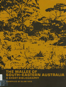
Book, The Mallee of south-eastern Australia : a short bibliography, 1973
mapsmallee region, south-eastern australia, geography, geology, climatology, water, agriculture, soils, botany, zoology, national parks, historical geography, australian literature, anthropology, sociology -
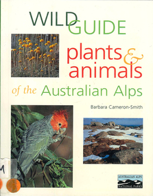 Victorian Aboriginal Corporation for Languages
Book, Barbara Cameron-Smith, Wild guide : plants & animals of the Australian Alps, 1999
Complex little book with details on animals, birds, insects, etc. with clear descriptions of each item.Maps, colour illustrations, colour photographsplant identification, australian alps, plants, animals, parks victoria, national parks and wildlife service, insects, reptiles, mammals, thredbo, mount hotham -
 Victorian Aboriginal Corporation for Languages
Book, City of Whitehorse, City Of Whitehorse parks and reserves: names and origins, 1985
Spiral bound book released by City of Whitehorse council. Alphabetically listed placenames within the local government area, with Melway map points and brief historical references to those places.Black and white photographs, colour photographsplace names, city of whitehorse, box hill, mitcham, mont albert, blackburn, surrey hills, burwood, nunawading, forest hill -
 Victorian Aboriginal Corporation for Languages
Book, Marilyn Gray, Flora of Melbourne : a guide to the indigenous plants of the greater Melbourne area, 2001
Comprehensive book giving illustration of plants and very specific, detailed descriptions.Colour photographs, illustrations, mapsindigenous plants, werribee river, mount evelyn, sunbury, mount eliza, botany, plant associations, park regeneration, propagation, weeds -
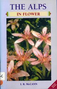 Victorian Aboriginal Corporation for Languages
Book, I R McCann, The Alps in flower, 2001
... Street Brunswick melbourne Alps Victorian National Parks ...Format using photographs and a brief description of each plant.Maps, colour photographsalps, victorian national parks association, bogong unit, alpine national park, mount buffalo national park, wonnangatta-moroka unit, kosciusko national park -
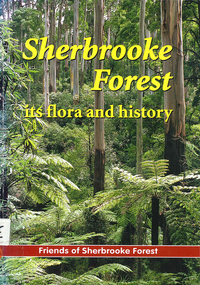 Victorian Aboriginal Corporation for Languages
Book, Friends of Sherbrooke Forest, Sherbrooke Forest : its flora and history, 2000
Notes on plants in the area, including swamp/water plants.Maps, b&w illustrations, b&w photographs, colour photographsdandenong ranges national park, indigenous vascular plants, weed management -
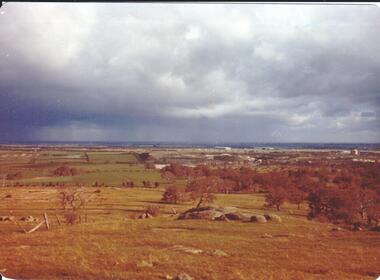
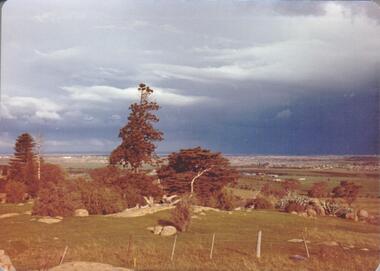 Hume City Civic Collection
Photograph, September 1994
Woodlands Park complex which includes 'Cumberland' and 'Dundonald' ruins and the Gellibrand Hill Quarries was acquired by the Victorian State Government in 1978 and is managed by Parks Victoria.A view taken from Gellibrand Hill looking east towards the developing suburb of Greenvale. There are small rocky outcrops in the foreground and a clump of conifers and cypress trees in the middle. The sky is very overcast and a range of mountains can be seen across the skyline. Coloured photograph with rounded corners and matt finish.woodlands park, gellibrand hill, greene, william pomeroy, anne, george evans collection -
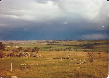
 Hume City Civic Collection
Photograph, September 1994
Woodlands Park complex which includes 'Cumberland' and 'Dundonald' ruins and the Gellibrand Hill Quarries was acquired by the Victorian State Government in 1978 and is managed by Parks Victoria.A view looking west towards the outer limits of the Tullamarine Airport taken from Gellibrand Hill. There is a small rocky outcrop in the middle of the photograph and trees are on the RHS of the image. Coloured photograph with rounded corners and matt finish.woodlands park, gellibrand hill, greene, william pomeroy, anne, george evans collection -
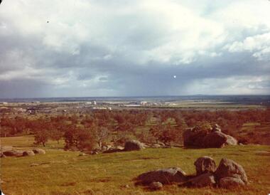
 Hume City Civic Collection
Photograph, September 1994
Woodlands Park complex which includes 'Cumberland' and 'Dundonald' ruins and the Gellibrand Hill Quarries was acquired by the Victorian State Government in 1978 and is managed by Parks Victoria.A view taken from Gellibrand Hill looking east towards the expanding suburb of Broadmeadows. Apart from a few rocky outcrops and small trees the open grassland slopes away to a small line of conifers. Coloured photograph with rounded corners and matt finish.woodlands park, gellibrand hill, greene, william pomeroy, anne, george evans collection -
 Hume City Civic Collection
Photograph, Sep-94
Woodlands Park complex which includes 'Cumberland' and 'Dundonald' ruins and the Gellibrand Hill Quarries was acquired by the Victorian State Government in 1978 and is managed by Parks Victoria.A view taken from Gellibrand Hill looking towards the recently constructed Tullamarine (Melbourne) Airport. The airport buildings are just beyond an outcrop of trees. Four rocky outcrops are spread around the foreground. Coloured photograph with rounded corners and matt finish.woodlands park, gellibrand hill, greene, william pomeroy, anne, george evans collection -
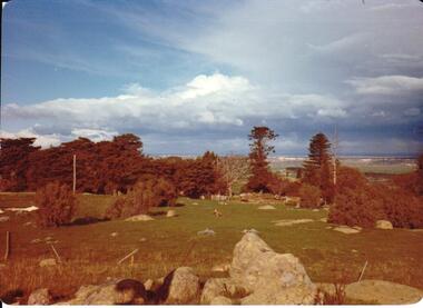 Hume City Civic Collection
Photograph, Sep-94
Woodlands Park complex which includes 'Cumberland' and 'Dundonald' ruins and the Gellibrand Hill Quarries was acquired by the Victorian State Government in 1978 and is managed by Parks Victoria.A view taken from Gellibrand Hill looking northwest. The open grassed area in the foreground is dotted with a number of rocky outcrops with conifers and cypress trees in the background. There are a few buildings in the distance.Coloured photograph with rounded corners and matt finish.woodlands park, gellibrand hill, greene, william pomeroy, anne, george evans collection -
 Creswick Campus Historical Collection - University of Melbourne
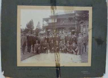
Photograph - Photograph of Department Forestry Refresher Course, 1913, R. Morton, Forestry Refresher Course, 1913, 1913
Department Forestry Refresher Course, 1913. The photograph shows the Conservator of Forests, H MacKay and the Chief Superintendent of State Plantations, John Johnstone, with the Forest Officers of the department outside the Victorian School of Forestry (Tremearne House) in Creswick.sepia photograph mounted on cardboard with separate cardboard backing.On the front: With compliments, Conservator of Forests. R. Morton Photo. Creswick. On the Back: Photo presented to Forester J.S.Ritchie, Glen Park. Passed down to Asst Supt Pltns. W.Ritchie and finally Divl Forester N.E. Division, R.J. Ritchie. On separate card backing: Forest Officers (with list of names) including J.Johnstone Chief Supt of Plantations, H McKay Conservator of Forests -
 Sunshine and District Historical Society Incorporated
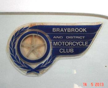
Club Sticker, BRAYBROOK & DISTRICT MOTORCYCLE CLUB
A meeting was held on 18th August 1947 at the East Sunshine Community Hall with the aim of forming a motor cycle club. The name BRAYBROOK MOTOR CYCLE CLUB was decided upon "as it would cater for riders and non-riding members in all surrounding districts". The first President was Don Minahan with Bert Watson as Secretary. They had been members of the Auto Cycle Union whose members became dissatisfied with the prize money awarded, so the Victorian Motorcycle Association (VMCA) was formed. The President of the VMCA (Mr. A. Clarke) attended the meeting on 3rd September 1947 which was held in the Hall behind the Sunshine Theatre. This became the regular meeting place. The new Braybrook Club affiliated with the VMCA joining clubs from Altona, Coburg, Essendon, Newport and Preston. Membership mostly came from recreational motor bike riders looking for more structured competitive riding experience and enjoyment. The club conducted its events on Sunday afternoons and as sport at that time was not permitted on Sundays, they overcame that obstacle by seeking a silver coin donation (pointing out that "two bob" was expected). The events were mainly dirt scrambles over open land which today is known as "off road". The favourite sites were Sunshine's ample open spaces such as Glengala Road and McIntyre Road, as well as Arundell Road (Keilor) and Laverton. For track racing experience the club formed a very basic dirt track on the open land in Glengala Road west of the original Sunshine Golf Club, which was very popular on Sunday afternoons for both riders and spectators. In the early 1950's Motorbike and Sidecar races were also witnessed on some Sundays, on a track near the corner of McIntyre and Furlong Roads, North Sunshine. During 1950 the Braybrook members voted in favour of allowing the Sunshine Club to amalgamate with them and form the BRAYBROOK AND DISTRICT MOTORCYCLE CLUB. The merger took place at the meeting on 10th July 1950 when office bearers were elected. The club disbanded in the mid 1960's due to the massive residential development occurring in the Sunshine district, and so activities were merged with the Newport Club. The above information is mainly compiled from Sunshine Advocate articles published on 29/8/47, 12/9/47, and 30/6/50, and from written details supplied by Mr. J. N. Willaton. Further details or corrections from interested readers are welcome.The Braybrook and District Motorcycle Club has not existed in its own right for several decades. The sticker depicting the club crest serves as a historical reminder that the club was once part of the local recreational scene.Dark blue, silver, and clear plastic sticker on right hand top corner of glass plate that previously was a side window of a car. Sticker has been left on the glass in case removal may damage it. BRAYBROOK AND DISTRICT MOTORCYCLE CLUB.Braybrook and District Motorcycle Clubmotorcycle club, sticker, club sticker, braybrook and district motorcycle club, braybrook -
 Sunshine and District Historical Society Incorporated
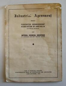
ICI Industrial Agreement (1952), Between Federated Ironworkers' Association of Australia (Victorian Branch) and Imperial Chemical Industries of Australia and New Zealand Limited, 1952
This 1952 document provides a historical record of the type of some of the manufacturing jobs at ICI Deer Park, and the pay scales and working conditions for the various jobs.20 page white paper booklet with brown stains and some wrinkling both possibly resulting from water contamination. The document is legible.Filed on Principal Registry Commonwealth Court of Conciliation and Arbitration 22nd September 1952federated ironworkers' association, industrial agreement, ici, icianz, ironworkers', 1952 -
 Sunshine and District Historical Society Incorporated
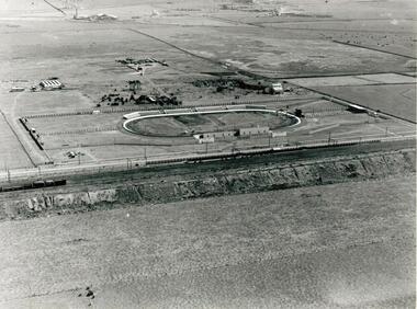
Photographs - WHITE CITY, Pratt, Charles Daniel, (1892 - 1968)
The White City Greyhound racing stadium was built at Tottenham in 1927, with the intention that mechanical lures and not live hares be used as pacemakers. The first meeting was held on 10 December 1927 but within 3 days, after strong lobbying by other sports bodies, the Victorian Government banned betting on greyhound racing if mechanical lures were used instead of live hares. This caused some financial problems to the shareholders. For a time the average weekly attendances were 9000, and races were held on Mondays, Wednesdays, and Saturdays. Whippet Races, Goat Races, Monkeys on greyhounds, and Professional Foot racing were also tried to attract attendances. After 28 years of bureaucratic interference, and using live hares as greyhound pacemakers, the White City stadium held its last meeting on 29 December 1955. On 31 December the Victorian Government finally allowed betting on greyhound races that used mechanical lures. Manufacturing industry (Olex Cables) took over the White City site. Transport to the White City stadium was provided by train, with only a single platform available on the Down side of Tottenham, even though double train lines existed. Special train services were run from Flinders Street to the White City platform, and for a while a parcels coach was provided for the transport of dogs. As industry developed in the area some trains also stopped at the White City platform in the mornings and late afternoons to transport workers. In 1981 when the grade separation at Ashley Street next to the Tottenham station was completed, the new train lines on the Upper Level came into operation, and so the White City platform was closed down and eventually demolished. The above historical information was sourced from the booklet "GOING TO THE DOGS" by Tom Rigg.Greyhound racing has always been popular in Melbourne's western suburbs. The White City stadium in Tottenham was a major centre for the sport until 1955, enabling those who could not afford race horses to take part in an animal racing sport. The demolition of first the stadium and years later the railway platform, has relegated the name White City and its past relevance to the western suburbs, into history.Two low aerial photographs of the White City Coursing stadium (Greyhound racing), plus a CD containing the same two images as well as a few other local images. The Coursing stadium was located about 500 metres from the Tottenham railway station on the down line towards Sunshine station. The photographs are thought to be from circa late 1920's to early 1930's, and one shows the view from the north facing south, while the other from the west facing east. The latter also shows built up areas of West Footscray and beyond.Only on the negatives at the State Library. We do not hold a copy of these.white city, greyhound racing stadium, coursing track, white city station, tottenham, whippet, gambling, live hare, mechanical lure -
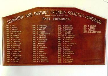 Sunshine and District Historical Society Incorporated
Honour Board - PAST PRESIDENTS of the SUNSHINE and DISTRICT FRIENDLY SOCIETIES DISPENSARY
Friendly Societies originated in the industrial areas of the United Kingdom. The first society in Victoria was formed in 1839 and by 1913 more than half of the Victorian population was insured by Friendly Societies in some fashion. The societies were financed by Members' subscriptions and offered health benefits and other welfare services, before these services were provided by the government. Doctors were paid by the societies to treat members free of charge, and Dispensaries were established to provide members with subsidised quality medicines. The Sunshine and District Friendly Societies Dispensary was established on the 1st of March 1930 with a membership of 896, and it was located in Sun Crescent Sunshine. The membership grew to 1052 within 4.5 years, and the number of prescriptions dispensed in the 6 months prior to November 30,1935 totalled 10,535. The Dispenser was Mr. C. H. Semmens. Most Friendly Societies operated democratically with office bearers changed regularly to prevent power cliques. The Sunshine Dispensary appears to have operated in the same way as the societies that owned it. The Advocate of 10 July 1936 reports that the seven newly elected office bearers or delagates were from the Friendly Societies; A.N.A., M.U.I.O.O.F., P.A.F.S., and G.U.O.O.F. The names of all the seven people can be found on the Honour Board, indicating that they each have served at least one term as President of the Sunshine Dispensary. The health professions and the Labour Governments of the 1940's wanted to see the involvement of Friendly Societies in health care broken. The Commonwealth Free Medicine Plan appears to have been drawing customers away from Friendly Societies Dispensaries in general. The Sunshine Dispensary placed several advertisements in the Sunshine Advocate during late 1950 urging members to remain loyal to it. By the 1980's the increase in entrepreneurial clinics and the availability of take away medicine helped to vastly diminish the involvement of Friendly Societies in health care provision. The 1936 Sunshine Advocate refers to the Sunshine and District United Friendly Societies Dispensary, with the same office bearers as the Presidents on the Honour Board but on which the 'United' is missing from the name of the Dispensary. The 1950 advertisements were placed by Sunshine U.F.S. Dispensary of 23 Sun Crescent. It is thought that all three names refer to the same business, but the writer stands to be corrected. The above is a compilation of information sourced from Sunshine Advocates published in January and July 1936, and in September, October and November 1950. It also draws on an article written by Elizabeth Willis and published online by the the Department of History (University of Melbourne), and on an article written by Mr. Bill Kelly of the Australian Friendly Societies Pharmacies Association, and also on an article by Museum Victoria Australia. Corrections to what has been written are welcome from interested readers.The Honour Board provides a historical record of the Presidents that served 61 terms on the Board of the Sunshine and District Friendly Societies Dispensary. It also provides a reminder that when a government does not adequately look after the welfare needs of its citizens, the people can band together to find ways of helping each other. The Sunshine Dispensary no longer exists, and a more recently established Community Pharmacy which operated in Hampshire Road could not compete against the discount pharmacies that have taken over. These new pharmacies sell a wide range of profitable product lines, as well as dispensing traditional prescription medications.Brown stained wood particle board with picture frame type edging. The board has six straight sides however it is not typical hexagon shaped. The top is composed of three straight short edges to give an almost rounded edge to an otherwise oblong shaped bottom section. On the board in gold coloured lettering are the names of 'brothers' and 'sisters' who served a total of 61 terms as PRESIDENTS of the SUNSHINE AND DISTRICT FRIENDLY SOCIETIES DISPENSARY, which was established on the 1st of March 1930. Eight of the men served more than one term with BRO. I. MILLER serving four terms, and BRO. F. RICHER serving three. The three women SISTER. I. REWELL, SISTER. C. JOHNSON, and SISTER. M.S. ARMSTRONG served one term each. There is no indication of when each person served, but it is believed that the term length was around six months and that the list is in chronological order. This conclusion results from seeing that BRO. W. ROONEY is the 11th listed President, and that the Sunshine Advocate of 10 July 1936 states that he was elected as the new President.sunshine and district friendly societies dispensary, honour board, 1st march 1930, 1/3/1930, sunshine u.f.s. dispensary, semmens, rooney, miller, richer, armstrong, rewell, johnson -
 Sunshine and District Historical Society Incorporated
Photographs (1928), 'QUARTER MILE' BRIDGE Construction, 1928
One man lost his life during the building of this bridge. The bridge was constructed by the Victorian Railways between 1927 to 1929 to carry a new double track goods line. This enabled trains from all parts of the state except Gippsland to have direct access to the Tottenham marshalling and sorting yards. These yards were constructed in the 1920's to relieve congestion in the Melbourne Yard near Spencer Street station. The congestion was being caused by the construction of suburban passenger platforms associated with the electrification of the suburban railway network. Initially the bridge was for goods trains but during the Second World War it was also used by troop trains. When the standard gauge line was built in 1962 all trains to Albury and Sydney have used this route, thus avoiding travelling through Essendon and Pascoe Vale on the suburban tracks. The standard gauge track across the bridge took the place of one of the broad gauge tracks so broad gauge trains crossing the bridge in either direction have to now use the same track. The bridge is 1,257 feet (383.13 metres) long and 180 feet (54.86 metres) above the water level. It is just 63 feet (19.2 metres) short of a quarter mile in length between abutments. There is a similar bridge on the same railway line crossing the Moonee Ponds Creek between Gowenbrae and Glenroy, however it is smaller at 1060 feet (323.08 metres) length and 115 feet (35.05) height.The bridge is now Victorian Heritage Registered under Number: H1197, and Heritage Overlay Numbers HO5, and HO107. On the Heritage Register it is named RAIL BRIDGE (ALBION VIADUCT). According to the Heritage Report the bridge is scientifically and architecturally important because of its large size, and because of the cost effective design features such as two girders per span (one for each track), the K bracing in the towers, and the broad flange beams as columns. When it was being built it was the largest trestle bridge in Australia, and until the Sydney Harbour bridge was constructed it was the highest railway bridge.Five B&W yellowing photos showing stages of construction of the Maribyrnong River Viaduct known as the Trestle Bridge but mainly known locally as the QUARTER MILE BRIDGE. It is a railway only bridge which runs over the Maribyrnong River between Sunshine North and Keilor East. A sixth image, which is not part of this set of photos, is included to show what the completed bridge looks like. -
Clunes Museum
Magazine, VICTORIAN ROSE NEWS, 2003
SEE PAGE 20 CLUNES ROSARIAN BARBARA KINLOCH AND HEPBURN COUNCILS' PARK AND GARDENS MANAGER ROBERT BEARD PLANTING VICTORIAN GOLD - PHOTO BY MARK GRIFFIN COURTESY OF THE WEEKLY TIMES.PLANTING OF ROSES TO COMMEMORATE 150TH ANNIVERSARY OF DISCOVERY OF GOLDPERIODICAL MAGAZINE TITLED VICTORIAN ROSE NEWS ISSUE SPRING VOL.29 NO.3 PRINTED 2003 COST $2.20 A5 COLOURED MAGAZINE ISSUED QUARTERLY. PAGE 20 REFERS TO 'VICTORIA GOLD ON THE VICTORIAN GOLDFIELDS'',' INITIATIVE INSTIGATED BY BARBARA KINLOCK OF CLUNES.local history, book, periodical -
Stawell Historical Society Inc
Book, Victorian Readers - Fifth Book
Used in Schools for teaching EnglsihBlue Hard Cover with title and Victorian Education logo on cover. Also a person's name barely visible and illegible. Page has top removedInside front Cover & Rear cover: Neville Heffernan 84 Harold Street Middle Park Phone MX4461 -
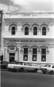 Stawell Historical Society Inc
Photograph, Victorian Savings & Loan Society in Main Street
Photograph of Victorian Savings & Loan Society. When built was the premises of Victorian State Savings Bank. Victorian Savings and Loan Society conducted their business there. In 2005 WestVic Computers occupy the building.Black and white photograph of a two story brick building with parapet top. Cement rendered arches over window. The building has 3 windows and a main entrance on the ground floor. The second story has 4 arched windows. Three cars are parked along the street in foreground.Victorian Savings and Loan Society stawell business -
 Stawell Historical Society Inc
Photograph - First Caravan Park - Botanic Gardens, Rotunda
Rotunda in first Caravan park - Botanic Gardens. Rotunda Demolished to make way for two cabins Circa 1972B/W Print of B/W photographVictorian Places -
Whitehorse Historical Society Inc.
Article, Antonio Park Primary School Flag Flying, 6/07/1994 12:00:00 AM
Nunawading Post article on Mitcham's Antonio Park Primary School's presentation of a City of Nunawading flag and a Victorian flagNunawading Post article on Mitcham's Antonio Park Primary School's presentation of a City of Nunawading flag and a Victorian flag as part of program teaching pupils about the three levels of Government in Australia.Nunawading Post article on Mitcham's Antonio Park Primary School's presentation of a City of Nunawading flag and a Victorian flagantonio park primary school, city of nunawading, primary schools -
Whitehorse Historical Society Inc.
Document, Victorian Government Gazette
Pages from Victorian Government Gazette from 1867 to 1887, describing parcels of land in Nunawading reserved for such purposes as parks, experimental and botanic gardens and cemetery.Pages from Victorian Government Gazette from 1867 to 1887, describing parcels of land in Nunawading reserved for such purposes as parks, experimental and botanic gardens and cemetery.Pages from Victorian Government Gazette from 1867 to 1887, describing parcels of land in Nunawading reserved for such purposes as parks, experimental and botanic gardens and cemetery.nunawading, parish of nunawading