Showing 1144 items
matching west side
-
 Kew Historical Society Inc
Photograph - Deep Rock Swimming Pool and Clubrooms on the Yarra, c.1925
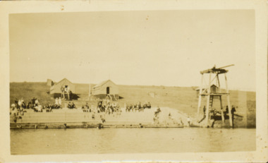
... on the west side of the Yarra was reputedly viewed by between 50,000...], a Solomon Islander. The dive from a special platform on the west ...The former Deep Rock Swimming Pool was about 500 yards [457 metres] above Dight’s Falls. It was there that the Deep Rock Swimming Club was established in 1906. This initial club was expanded in 1916 to incorporate a life-saving club. In 1918, John Wren, the president of the club offered the club £1000, and undertook to sponsor a patriotic carnival in March 1918, at which swimming champions would take part. The ‘pool’ was to achieve fame as the venue for a world record-breaking ‘swallow dive’ of 205 feet 9 inches [63 metres] by ‘Prince Wickyama’, [aka Alec Wickham], a Solomon Islander. The dive from a special platform on the west side of the Yarra was reputedly viewed by between 50,000-100,000 spectators, with funds going to the State War Council. The Herald, 25 March 1918, claimed that the wide area occupied by spectators made more precise estimates impossible. In the 1980s, the construction of the Eastern Freeway, and the consequent re-routing of the Yarra River led to the site of the Deep Rock Pool being obliterated. A small cairn and plaque on the Fairfield side of the river now marks its former site.Very rare early photograph off the Deep Rock swimming pool. The pool and its built structures are historically and socially important to the people of Collingwood, Fairfield and Kew. Small, faded, Gelatin Silver print positive photograph of the Deep Rock Swimming Pool situated on the Yarra at Collingwood and Fairfield. The famous diving tower is at the right of the photo. The built structures were constructed for the Deep Rock Swimming and Life Saving Club. People are sitting on the terraces above the river. "Bathing Club. Deep Rock on the Yarra. Studley Park Melbourne. Please credit E.J. Thomasson Collection"deep rock swimming pool, deep rock swimming club, deep rock lifesaving club, swimming -- river yarra, river yarra -
 Glenelg Shire Council Cultural Collection
Photograph - Photograph - Julia Street, Portland, 1930s
... . Portland, taken from middle of road, looking west, left hand side... from middle of road, looking west, left hand side, block ...Black and white photo, white border. View of Julia St. Portland, taken from middle of road, looking west, left hand side, block between Bentinck and Percy Streets. Four cars, 1 motorbike, road not sealed.'JULIA STREET, PORTLAND', black print, lower borderphotography, julia street, portland -
Glenelg Shire Council Cultural Collection
Work on paper - Public Baths for the Borough Council of Portland
... right is the title. Depicts the South Side Elevation, West.... Depicts the South Side Elevation, West Front Elevation ...Colour plans showing the public baths of Portland. Top right is the title. Depicts the South Side Elevation, West Front Elevation and swimming area as well as several sectionsThis is the plan ***** to the Contrct / entered into this Tenth day of October 1888 / for the erection of the new Baths for the Borough of / Portland Top Right Public Baths / For the / Borough Council / of / Portland / Wm Mackay / archt Scale 16 Feet TO 1 Inchportland baths, borough of portland, william mackay -
 Bendigo Historical Society Inc.
Document - ALBERT RICHARDSON COLLECTION: CARLISLE UNITED MINE GARDEN GULLY LINE
... situated on the west side of Bennett Street in about a length... were situated on the west side of Bennett Street in about ...Eight page handwritten document with details of the Carlisle United Gold Mine at Long Gully. The lease was 76 acres, 660 yards on line of reef. The Kent shaft was the next mine north Havilah Road, Boldt Street's corner. 'The Carlisle United was formed by the amalgamation of ttte companies, the Old Carlisle, the North Garden and the Passby. These mines were situated on the west side of Bennett Street in about a length of a few hundred feet, with the Passby on the Casley Street corner. And the old Carlisle and North Garden only recently being unearthed beneath the Unity, 'Carlisle' sand heap.' Details about the mining plant, the main shaft, the winding engine air compressor, stone crusher, and engine house are given. The Kent shaft and steel poppet legs are described. Four early claims on the Carlisle United ground are listed: Morgan, Kirshner and Co., Boyd and Co. Claim, Shanks and Co's claim and Day and Co's claim.bendigo, mining, carlisle united -
 Ballarat Tramway Museum
Negative, Wal Jack, early 1950's
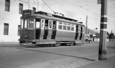
... of East in the rear canopy and the West in the side destination... of East in the rear canopy and the West in the side destination ...Negative and Digital images of the Wal Jack Ballarat Negative file of Geelong 21 at the West terminus with the Telegraph Hotel in the background. The tram has the destination of East in the rear canopy and the West in the side destination. The adjacent pole has the End of section sign and the painted markings.trams, tramways, geelong, west, signs, tram 21 -
 Ballarat Tramway Museum
Slide - 27 mm sq slide/s - set of 6, Lilian Butler, City area - Sturt St, August or September 1971
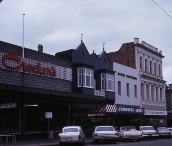
... in the background. .3 - Sturt St west side looking west up Lydiard St... in the background. .3 - Sturt St west side looking west up Lydiard St ...Yields information about the streetscapes of the Sturt St - Grenville St and City Loop.Set of six Colour 27 x 27 mm slide in a Kodachrome cardboard mount. .1 - Sturt St with the Crockers, Hairdresser, Ludbrook's shoes and Eyres Brothers shops in the view. .2 - Photo of a passenger boarding a tram and a young lady leaving the tram on the north side of the City stop with the SEC building in the background. .3 - Sturt St west side looking west up Lydiard St with Coles & Gerrard, Mechanics Institute, Unicorn Hotel and other buildings - taken from the west end of the City loop. .4 - Two trams parked in city loop and one bogie tram crossing Grenville St with the Big W and Dickins Stores in the background. .5 - Tram 21 parked in the City Loop. .6 - Sturt St - city stop with seats shown, passengers waiting, tram stop sign, looking west with the Town Hall on the left hand side and Myers in the background. Slide mount date August or September 1971. Photo from the collection of Lilian Butler.ballarat, tramways, trams, sturt st, tram stops, city, shoppers, passengers, city loop, grenville st, tram 21 -
 Bendigo Historical Society Inc.
Document - VICTORIA HILL - THE BENDIGO DIGGINGS, PRELIMINARY DRAFT FOR BROCHURE
... by the mineral haulage line, and the Central Nell Gwynne mine on the west... by the mineral haulage line, and the Central Nell Gwynne mine on the west ...BHS CollectionNine typed pages of notes on a preliminary draft for a brochure on the Bendigo Diggings. First part is the objective which is to preserve the mining history and to have exhibits in the places they were used, e.g. quartz mining machinery exhibited in a quartz mining area, not on an alluvial field. Part B is historical notes on the area. Part C is the Site - Victoria Hill area. Part D is Stage One which consists of carpark area, technological museum, restaurant, mineral haulage line, picnic ground, earthworks and planting over the area. Part E is Stage Two which will consist of the open-air exhibits, in the area surrounded by the mineral haulage line, and the Central Nell Gwynne mine on the west side of the site. Part F is Stage Three which will consist of the winery, the steam tram track, the lake, the wildlife sanctuary and various buildings associated with gold mining. Part G is Costing with the prices to be filled in. Parts H and I are the Appeal and the Committee. Details to be filled in. Notes prepared by Albert Richardson.mining, marketing, victoria hill, victoria hill, the bendigo diggings - preliminary draft for brochure, aust national travel association, tullamarine jetport, emu bottom homestead, kyneton historical museum, chinese joss house, eaglehawk museum, whipstick scrub, cairn curran reservoir, castelmaine historical museum and market hall, national trust, ballarat hiatorical park, echuca's hopwood gardens, swan hill folk museum, gibson's mount alexander no 2 squatting run, captain brown, chief commissioner wright, hustler's reef, thomas hustler, mining board, drainage of reefs act 1862, first world war, bendigo amalgamated goldfields, second world war, sandhurst, w c vahland, battery trams, horse trams, steam trams, electric trams, central nell gwynne mine, theodore ballerstadt, george lansell, new chum hill, ballerstadt's open cut, 180 mine, new chum syncline battery, william rae, victoria quartz, wittscheibe's 'jeweller's shop', luffsman and sterry, gold mines hotel, adventure, bendigo and district tourist association, bendigo city council, bendigo branch of the royal historical society of victoria, professor brian lewis, school of architecture and building at the university of melbourne, taylor horsfield, lord robert cecil, south australian gold commissioner -
 University of Melbourne, Burnley Campus Archives
Album - Colour prints and negatives, Garden Views, etc, c. 1991
... in Herbaceous Border.(21) Students on West side of Administration... in Herbaceous Border.(21) Students on West side of Administration ...34 colour photographs with negatives. (1) Principal's garage in the Herb Garden area, used for Arboriculture, demolished shortly after in 1992. (2,3)North end of Administration Building. (4) Front of Administration Building. (5,6) Front of Administration Building in winter. (7) ?. (8) Camellia in Emily Gibson Bed. (9) Nursery. (10) Native Garden pool, Andrew Smith, Gardener. (12) Native Garden pool. (13) Melaleuca Lawn. (14)Students outside front of Administration Building. (15-20) Paula Cave, Gardener and Jasmine (in pink) Apprentice working in Herbaceous Border.(21) Students on West side of Administration Building. (22-25) Magnolia in Emily Gibson Bed. (26,27) Pond in a garden not Burnley. (28) Looking through fence to Field Station, Andrew Smith, Gardener. (29) Herbaceous Border and Oak Lawn. (30) Luffmann Ponds and Summer House. (31) Garden view, Wisteria Walk behind. (32) Students in Citriodora Courtyard. (33,34) Students.principal, garage, herb garden, arboriculture, administration building, camellia, emily gibson bed, nursery, native garden, pool, andrew smith, gardener, melaleuca lawn, students, paula cave, gardener, apprentice, herbaceous border, magnolia, ponds, fence, field station, oak lawn, luffmann ponds, summer house, garden views, wisteria walk, citriodora courtyard, lily ponds, orchard -
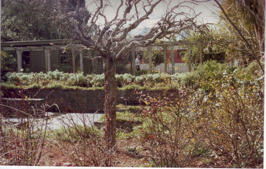
 Flagstaff Hill Maritime Museum and Village
Ceremonial object - Church Bell, Before 1855
... at the wreck site was described as "found on the west side towards... at the wreck site was described as "found on the west side towards ...This artifact is a large brass bell. It was retrieved from the Schomberg wreck by local divers in the 1970s. Its location at the wreck site was described as "found on the west side towards the stern" the vessel remains lying on a north-south axis, with the bow pointing towards the shore as a result the bell was assessed from this position to have formed part of the cargo. The view that this was not a ship's bell belonging to the Schomberg is gained from two other 'Schomberg Bells' in the Flagstaff Hill collection, both of which have the vessel's name prominently etched into their outer surface. Additional indications indicate that this bell was not intended for maritime use due to the bell's rounded 'bell-curve' shape suggesting it was melodically tunable. Also the detailed basket-type fittings on the bell dome that would allow the bell to be suspended by ropes rather than just bolted to a yoke. The bell is currently on display at Flagstaff Hill, categorised as a church bell part of the Schomberg's cargo that was intended for use in a church within the Victorian colony. As the Colony of Victoria became more established, and its population expanded with the Gold Rush and other emigration from Britain, the demand for regular religious services and permanent church buildings also grew. We will never know if this bell was a specific order or part of an enterprising bell founder's consignment of general stock to a wholesale supplier in Melbourne. A cargo manifest for the Schomberg has unfortunately never been found. The shipwreck of the Schomberg is regarded as of significance to Victoria and is registered on the states Heritage list (S 612). The Schomberg wreck has great historical significance as a rare example of a mid 19th century large, fast clipper ship intended to transport cargo and passengers between England and Australia. The vessel that carried this bell represents the marine advances made in an attempt to break established sailing records between Europe and Australia. Flagstaff Hill holds a noteworthy collection of artefacts from the Schomberg shipwreck. The collection as a whole is primarily significant because of the relationship the objects have archaeologically, not only to highlight the story of the Schomberg ship and later it's wrecking but have an important potential to interpret the story and progression of maritime shipping in the 19th century. The church bell has a standard bell-curve shape and is dull bronze in colour. A large brass bell, plain and without visible maker marks, but with traditionally intricate basket-type cast fittings for suspension from a yoke by a number of ropes or chains. Approximately 3/8 of the bell’s outer surface bears a thin layer of marine growth and limestone accretion, and there is some minor pitting and spots of light verdigris over the remainder. The bell mouth, or lip, is slightly compressed-in in two places. It was retrieved from the wreck of the Schomberg. warrnambool, flagstaff-hill, flagstaff-hill-maritime-museum, maritime-museum, shipwreck-coast, flagstaff-hill-maritime-village, schomberg, shipwrecked-artefact, clipper ship, black ball line, 1855 shipwreck, aberdeen clipper ship, captain forbes, peterborough shipwreck, ss queen, brass bell, church bell -
 Eltham District Historical Society Inc
Photograph, Tess Justine (Nillumbik Shire Council), Construction work on replacement of Murray's Bridge over the Diamond Creek, Eltham North, 31 Mar 2022
... on the west side of the Creek disappeared. A farm bridge over Diamond... on the west side of the Creek disappeared. A farm bridge over Diamond ...Construction work on replacement of Murray's Bridge over the Diamond Creek on the Diamond Creek Trail Mary (Sweeney) Murray and John Wright Murray selected 80 acres, Lot C Section 16 and Lot 5 Section 17 Parish of Nillumbik, under an occupation license in 1866. John died in 1867 and freehold was granted to his son John in 1873. The farm was known as ‘Laurel Hill’. John Junior was an Eltham Shire councillor and sometime president from 1887 up until 1897. He added Lot A Section 16 to the farm in ca1888. John and his younger brother James arranged to rent/purchase Lot B Section 17, across Diamond Creek to the west, in ca1900. It appears that John and James farmed separately for a few years, with a new homestead built for James ad family on the high point of Lot B Section 17 in ca1910. John sold off Lot 5 Section 17 in 1912. When John died in 1912 James took over the land on both sides of the Diamond Creek. The old homestead on the west side of the Creek disappeared. A farm bridge over Diamond Creek from this period may have been located close to the northern boundary of the farm. John Langlands, owner of the farm known as ‘Ihurst’ on the west side of Diamond Creek to the south of the Murray’s land, died in 1907. In 1909 his land was then subdivided into 100 lots to become the ‘Glen Park Estate’. Other similar subdivisions of nineteenth century farms around Eltham in this period included the ‘Franktonia (or Beard’s) Estate’ to the northeast and ‘Bonsack’s Estate’ between Eltham and Greensborough. Soon after the opening of the railway extension line from Eltham to Hurstbridge in 1912, Glen Park and nearby residents including James Murray agitated for a railway station or siding to be located half-way between Eltham and Hurstbridge, so that the Glen Park residents who used the railway daily did not have to walk into the Eltham or Hurstbridge stations. Some believed Coleman’s Corner (opposite Edendale Farm) was an appropriate spot for the platform. James Murray was among those who thought the railway should be located on his land, closer to half-way between Eltham and Hurstbridge stations. The Railways Commissioners warned that the locals would have to fund these works themselves. The Glen Park Estate residents initially had difficulty accessing Eltham by road, with only an old low-level bridge over Diamond Creek at the south end of their estate. A new timber trestle bridge across the creek, now on Wattletree Road, was opened in 1915. Road access to the north was gained in 1927 when the new Murray’s Road, which crossed the Murray’s land, was built. Residents continued to agitate for a Glen Park station. By 1926 the Railways Commissioners’ preferred site was on the Murray’s land. They arranged an estimate of cost of a full-length platform. The estimate was too much for the locals, who in 1928 argued unsuccessfully for a shorter and hence cheaper platform. By 1929 Murray had agreed to donate the land, but the locals would still have to fund the works. Murray decided, unilaterally it would appear, to commence work on a timber trestle road bridge over Diamond Creek to link the new Murray Road to the proposed station. Late in 1929 he stopped work on the bridge, for reasons unknown, but started work again and completed the bridge in 1931. There is no further newspaper evidence of the campaign for the Glen Park station until 1939, when Murray and another local, Mr Maxwell, met the Railways Commissioner. The Glen Park locale now included 45 homes on the west side of the creek and 20 on the Eltham side. Most of the residents used the train every day. The Commissioner remained adamant that only a full-length platform could be built for safety reasons. It appears the campaign dissolved at this point. The increasing move to cars may have had an impact. There is no evidence of Murray’s bridge ever being connected to Murray’s Road, or of it having wide use for any purpose by locals. James Murray died in 1947 and the farm was taken over by his son James (Jim). Jim started to sell off parts of the farm in the 1980s, retaining a few acres around the ca1910 homestead and building a new house there. Recreation reserves were established along the creek. In ca1990 Murray’s bridge was renovated with steel girders as part of a bike/pedestrian path in the reserve. The old farmhouse was demolished in ca2014. Born digital image (5)diamond creek (creek), diamond creek trail, murrays bridge, ‘laurel hill’, john wright murray, mary (sweeney) murra, john murray jnr, james murray, john langlands, ‘ihurst’, ‘glen park estate’, beard's estate, franktonia, bonsack's estate, glen park estate, glen park railway station -
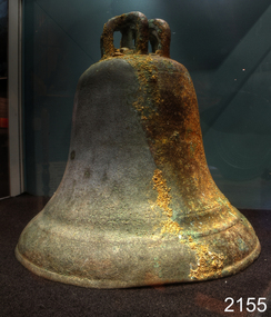
 Orbost & District Historical Society
black and white photograph, C1914
... , and closed in 1987. The station was located on the west side..., and closed in 1987. The station was located on the west side ...This is a photograph of a railway camp, set up to house workers and their families when building the Bairnsdale to Orbost Railway from 1914-1916. The man in the foreground was one of three men killed in an explosion "noon on the railway construction works at Hagen's Cutting, about two miles from Orbost, three men being killed. The victims were John Carroll, con- tractor, his son, Peter Carroll, and John Sullivan, a navvy. The gang had just finished work, and the three stayed behind to draw a blasting charge, which had missed fire yesterday. J. Carroll was using a pick, and it is presumed that the tool struck a percussion cap, and fired the charge. He and Sullivan were killed instantly, Carroll being literally blown to pieces. Fragments of his body and garments were recovered from the surrounding bush, and the main portion of the trunk, with leg attached, was hurled a distance of 200 yards. Peter Carroll was terribly- injured, and he died before medical aid arrived." (from The Mercury Saturday March 114 1914) The Bairnsdale-Orbost railway was opened in 1916 to serve the agricultural and timber industry. Because of the decline in traffic and heavy operating costs, the line was finally closed in August, 1987. Orbost Railway Station was opened on Monday 10 April 1916 as the terminus of the Orbost railway line, and closed in 1987. The station was located on the west side of the Snowy River despite the town of Orbost being on the east side of the river, in order to save on the costs of a bridge over the river, which at the time had highly variable levels. This item is associated with the history of the Orbost-Bairnsdale railway line and therefore reflects the role that the rail line played in the social and economic history of Orbost.A black / white photograph of a campsite. There is a kitchen outside a rough construction. Men and women are standing in the backgroundd with one man and a dog in the foreground.on back - "Man with dog killed in explosion"orbost-railway transport railway-bairnsdale-orbost explosion-railway -
 Flagstaff Hill Maritime Museum and Village
Photograph - Historical, building, Lighthouse Keeper's Quarters Warrnambool, Ca. 1917
... in the garden on the west side of the building. A washhouse, these days... in the garden on the west side of the building. A washhouse, these days ...This photograph of the Warrnambool Lighthouse Keeper's Quarters was donated together with an accompanying letter written by John Lindsay on October 21st, 1997. The letter was addressed to Howard Nicholl, the Director of Flagstaff Hill at that time. The following information was gleaned from the contents of the letter and the labels attached to the photograph:- The photograph of the Cottage was taken in about 1917. The woman is Gertrude Shade, married to James Shade, who was the Warrnambool Town Council's Officer responsible for keeping records of Shipping activity entering and leaving the busy Port of Warrnambool. The couple and their children, Janet and William, were residents of the Assistant Lighthouse Keeper's Quarters at that time. The family is pictured in the garden on the west side of the building. A washhouse, these days referred to as a laundry, is behind the building and had already been removed when the Flagstaff Hill Planning Board had access to the site in 1972. The corrugated iron veranda was replaced in the 1980s with a smaller covered entry. Janet Shade married the man who lived across the road, Stewart Lindsay, in 1935. Stewart was employed by Nestle at the age of sixteen, working in the export department. He was acting Manager when the Manager became ill, supervising the loading of dairy products and biscuits into the holds of the waiting ships, where they were then exported to Indonesia. Many of the ships were registered in Liberia and the seamen were called 'lascar seamen, or Indian Sailors. Janet and Stewart had a son, John Stewart Lindsay, who was a Pharmacist, a member of the Warrnambool City Council, the Mayor of the City of Warrnambool, a former Director of Flagstaff Hill, and Chairman of the Flagstaff Hill Advisory Committee.This photograph has significance as a historical record of the Warrnambool Lighthouse Kerr'er's Quarters in 1917. The photograph connects the cottage to local families, to local industry, to the Port of Warrnambool, and to overseas exports from Warrnambool. Photograph from c. 1917 depicts the western side of the Warrnambool's Lighthouse keeper's Quarters constructed in bluestone, which was where the Assistant Lighthouse Keeper resided. The image shows the corrugated iron lean-to, and other rooms that were added to the original building after 1872, which were removed in the 1970s due to their poor condition. The members of the family pictured were residents at the time; Gertrude Shade (Mrs James Shade), her daughter Janet and her son William. Inscriptions are on the reverse and the accompanying envelope. Typed label "Gertrude Shade with William and Janet. Lighthouse Keeper's Cottage, Flagstaff Hill, Merri St Warrnambool" Stamp "John Stewart Lindsay, Pharmacist, --0 Thompson Street Warrnambool 3280" "HOWARD NICHOLL / FLAGSTAFF HILL / MERRI STREET" " KEEP OUT OF REACH OF CHILDREN / Lindsay's Pharmacy / 119 Liebig Street, Warrnambool / Tel. 5561 4310" [round symbol of mortar and pestle] Typed letter (from John Lindsay to Howard Nicholl, October 21 1997)flagstaff hill, warrnambool, maritime museum, shipwreck coast, great ocean road, lighthouse keeper's quarters, lighthouse keeper's cottage, gertrude shade, james shade, janet shade, john stewart lindsay, stewart lindsay, nestle, warrnambool exports, port of warrnambool, planning board, 1917, howard nicholl, william shade, export to indonesia, janet lindsay -
 Ballarat Tramway Museum
Slide - 27 mm sq slide/s - set of 3, Lilian Butler, Sturt St and Ripon Sts, 1971
... Britton 26/9/2016 - by e-mail) 3 - looking west - South side... west with short tram stop pole and Ampol service station sign ...Yields information about Ripon St, Talbot St.Set of 3 Hanimex slides - what cardboard mounts: 1 - View Point line junction at Ripon St, looking north west with short tram stop pole and Ampol service station sign on the right. 2 - Water column North West corner of Sturt Street and Talbot Street (opposite the Fire Station). Column long gone. (Advised by Neville Britton 26/9/2016 - by e-mail) 3 - looking west - South side of Sturt St. Photo from the collection of Lilian Butlerballarat, tramways, trams, sturt st, view point, ripon st, tram stops -
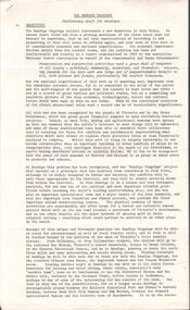
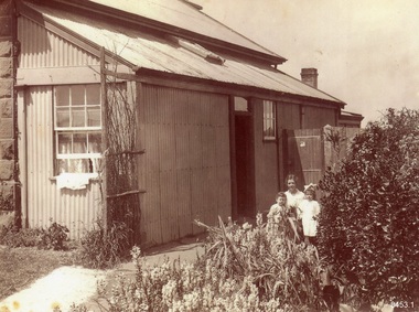
 Kew Historical Society Inc
Work on paper, Madford: the property of A.S. King Esq
... is the south-facing main facade and the west facing side. After A.S...-facing main facade and the west facing side. After A.S. King ...The Victorian-era mansion Madford in Wellington Street had several incarnations before it was finally demolished. While the precise details of its original construction have not been discovered, we know that it was originally named Elm Lodge, and that the property was offered for sale in 1863 by Thomas Mitchell, of the firm Mitchell & Bonneau, wholesale ironmongers and merchants. The house was sold in about 1873 to William Siddeley (1827-1905), who was described on the occasion of his death as ‘the father of Australian shipping’. The next owner was Arthur Septimus King (1827- 99), who renamed the house Madford after his purchase of the property in 1875. It was A.S. King for whom this artwork was completed. Following King’s death in 1899, portions of the property were sold, including to the Borough of Kew in 1905, to form the Alexandra Gardens. Then, in 1920, the house and its remaining lands were sold to the Catholic Church who opened St Anthony’s Home for Children on the site in 1922. That building was promptly demolished, and the site redeveloped circa 1976.Gift of James Pearson, 2022This fine perspective drawing of the architectural elements of Madford [formerly Elm Lodge, later St Anthony's Home for Babies] is contrasted with the freer addition in watercolour of the layout and plants of the garden facing Wellington Street. The view selected is the south-facing main facade and the west facing side. After A.S. King purchased the house in 1875, it was extended with new wings at the rear to accommodate his large family. There is no indication of these extensions in the painting so its creation must predate the renovations, and probably depicts the original building on the site."MADFORD / The Property of A. S. KING Esq"elm lodge, madford, st anthony's home for babies, houses -- wellington street -- kew (vic.), thomas mitchell, william siddeley, arthur septimus king -
 Ballarat Tramway Museum
Slide - 35mm slide/s - set of 6, Noel Simons, 22/05/1971 12:00:00 AM
... a motor cyclist stopped for tram and shows tram stop on the west... a motor cyclist stopped for tram and shows tram stop on the west ...Set of 6 Kodachrome transparencies taken on 22/5/1971. 1171.1 - Tram 33 at Sebastopol terminus, showing destination of Lydiard St. Nth, with Royal Mail Hotel in the background and three parked cars. Tram has "Twin Lakes" sign on front dash. 1171.2 - as for 1171.1 but taken from other side of tram, has hotel in part of photo. Shows arrangement of tram terminus signs on a pole in the background. 1171.3 - Tram 26 just after arrival at the Lydiard St. terminus, with passengers getting off and driver about to swap ends. Destination has been changed to Sebastopol. Has Lydiard St. shelter in the right edge of the photo. 1171.4 - as for 1171.3 - but with pole turned and looking back along street towards city. Shows the undulating nature of the street. 1171.5 - Tram 26 outbound in Albert St. for Sebastopol, crossing the street near Ophir St. Has a motor cyclist stopped for tram and shows tram stop on the west side of the road. 1171.6 - Tram 26, close up of tram at the Sebastopol terminus with two cars parked along side. Tram has destination of Lydiard St. Nth.1171.1 - "No. 33 at Sebastopol Terminus" and initials "BC" in bottom left hand corner. 1171.2 - "No. 33 at Sebastopol Terminus" and initials "BC" in bottom left hand corner. 1171.3 - "No. 26 at Lydiard St. North terminus" and initials "BC" in bottom left hand corner. 1171.4 - "No. 26 at Lydiard St. North terminus" and initials "BC" in bottom left hand corner. 1171.5 - "No. 26 crossing from left side of Albert St. Sebastopol to right side near Ophir St." and initials "BC" in bottom left hand corner. 1171.6 - No. 26 at Sebastopol Terminus" and initials "BC" in bottom left hand corner. All slides have date stamp of "22 May 1971" in purple ink and Kodak developing date of "Jun 71M7" in red ink. tramways, trams, sebastopol, lydiard st nth, royal mail hotel, tram stops, tram 33, tram 26 -
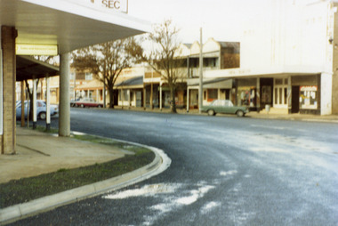 Charlton Golden Grains Museum Inc
Photograph, Charlton Shire, High Street Charlton 1987, c. 1987
... on the west end and south side of High St. Photo is slightly blurry... on the west end and south side of High St. Photo is slightly blurry ...Bend in High St looking towards cinema and shops. Charlton Shire High St series 1987Colour photo of High St corner looking towards the shops on the west end and south side of High St. Photo is slightly blurry. Green car parked in front of cinema. SEC sign on top of building at the top of the photo.charlton high st, charlton, rex theatre, business -
 Glen Eira Historical Society
Album - Album page, Glenferrie Street, 4, Circa 1972
... on the west side. Haddon named the house "Anselm". Also built... on the west side. Haddon named the house "Anselm". Also built ...This photograph is part of the Caulfield Historical Album 1972. This album was created in approximately 1972 as part of a project by the Caulfield Historical Society to assist in identifying buildings worthy of preservation. The album is related to a Survey the Caulfield Historical Society developed in collaboration with the National Trust of Australia (Victoria) and Caulfield City Council to identify historic buildings within the City of Caulfield that warranted the protection of a National Trust Classification. Principal photographer thought to be Trevor Hart, member of Caulfield Historical Society. Most photographs were taken between 1966-1972 with a small number of photographs being older and from unknown sources. All photographs are black and white except where stated, with 386 photographs over 198 pages. From Glen Eira Heritage Management Plan 1996 by Andrew Ward: In 1905, most of portion 27 was vacant land, however Glenferrie Street had been formed and the land subsequently subdivided. In 1906, Robert Joseph Haddon, architect and painter, designed and built for his private residence, a brick house on the west side. Haddon named the house "Anselm". Also built on the property were a garage and fibro cement studio. "Anselm" is architecturally important at the State level as a substantially intact, highly personalised and boldly expressed house expressive the Arts and Crafts movement and incorporating Art Nouveaux enrichment in a variety of forms, the use of ornamental terra cotta tiles to the comer tower being of special note. Its importance at the State level is strengthened by its place as the home of the noted architect and Melbourne's most influential exponent (Freeland, J.M., Architecture in Australia, p. 213) of the Art Nouveaux movement.https://vhd.heritagecouncil.vic.gov.au/places/4442 Victorian Heritage Register: What is significant? Anselm was designed by noted English born architect Robert Joseph Haddon(1866-1929) as his own house and constructed in 1906. A single storey Arts and Crafts influenced red brick house with attic, Anselm has a pyramidal slate roof with prominent chimney stacks. There is a octagonal corner tower with saucer shaped domed roof surmounted by a weather vane, and the tower has decorative terracotta panels immediately below the eaves line. The front door opens immediately into a large living or common room, screened from view by a timber and bottle glass screen. The large room was designed to function as a drawing and dining room. The house is rich with hand crafted details including door and window furniture, wrought iron gutter brackets, fireplaces (one with built in wood box), and fire tools. The interior decoration includes hand painted frieze of Port Phillip in the study, and a hand painted frieze of turbulent sea with sailing boats in the tiled bathroom. There is a small hand painted tile at the base of the tower which states ?This building was erected AD1906 from designs by Robt J Haddon FRIBA,Lond FRIVA Melb Architect?. He also designed an attic addition which was constructed in 1927. Anselm is substantially intact although the double casement window immediately to the south of the front door was originally circular....Page 60 of Photograph Album with three exterior photographs (one portrait and two landscape) of Anselm.Hand written: 4 Glenferrie Street [top right] / ANSELM 4 Glenferrie St [under top photo] / 60 [bottom right] trevor hart, anselm, art nouveaux, arts and crafts, tower, bay window, glenferrie street, robert joseph haddon, 1900's, terra cotta tiles, double storey, caulfield north, corner tower, gates, cast iron work -
 Glen Eira Historical Society
Album - Album page, Glenferrie Street, 4, Circa 1972
... on the west side. Haddon named the house "Anselm". Also built... on the west side. Haddon named the house "Anselm". Also built ...This photograph is part of the Caulfield Historical Album 1972. This album was created in approximately 1972 as part of a project by the Caulfield Historical Society to assist in identifying buildings worthy of preservation. The album is related to a Survey the Caulfield Historical Society developed in collaboration with the National Trust of Australia (Victoria) and Caulfield City Council to identify historic buildings within the City of Caulfield that warranted the protection of a National Trust Classification. Principal photographer thought to be Trevor Hart, member of Caulfield Historical Society. Most photographs were taken between 1966-1972 with a small number of photographs being older and from unknown sources. All photographs are black and white except where stated, with 386 photographs over 198 pages. From Glen Eira Heritage Management Plan 1996 by Andrew Ward: In 1905, most of portion 27 was vacant land, however Glenferrie Street had been formed and the land subsequently subdivided. In 1906, Robert Joseph Haddon, architect and painter, designed and built for his private residence, a brick house on the west side. Haddon named the house "Anselm". Also built on the property were a garage and fibro cement studio. "Anselm" is architecturally important at the State level as a substantially intact, highly personalised and boldly expressed house expressive the Arts and Crafts movement and incorporating Art Nouveaux enrichment in a variety of forms, the use of ornamental terra cotta tiles to the comer tower being of special note. Its importance at the State level is strengthened by its place as the home of the noted architect and Melboume's most influential exponent (Freeland, J.M., Architecture in Australia, p. 213) of the Art Nouveaux movement. Victorian Heritage Register https://vhd.heritagecouncil.vic.gov.au/places/4442 What is significant? Anselm was designed by noted English born architect Robert Joseph Haddon(1866-1929) as his own house and constructed in 1906. A single storey Arts and Crafts influenced red brick house with attic, Anselm has a pyramidal slate roof with prominent chimney stacks. There is a octagonal corner tower with saucer shaped domed roof surmounted by a weather vane, and the tower has decorative terracotta panels immediately below the eaves line. The front door opens immediately into a large living or common room, screened from view by a timber and bottle glass screen. The large room was designed to function as a drawing and dining room. The house is rich with hand crafted details including door and window furniture, wrought iron gutter brackets, fireplaces (one with built in wood box), and fire tools. The interior decoration includes hand painted frieze of Port Phillip in the study, and a hand painted frieze of turbulent sea with sailing boats in the tiled bathroom. There is a small hand painted tile at the base of the tower which states ?This building was erected AD1906 from designs by Robt J Haddon FRIBA,Lond FRIVA Melb Architect?. He also designed an attic addition which was constructed in 1927. Anselm is substantially intact although the double casement window immediately to the south of the front door was originally circular....Page 61 of Photograph Album with one exterior photograph (portrait) of Anselm.Hand written: 61 [bottom left] trevor hart, anselm, art nouveaux, arts and crafts, tower, bay window, glenferrie street, robert joseph haddon, 1900's, terra cotta tiles, double storey, caulfield north, corner tower, brick house, attics -
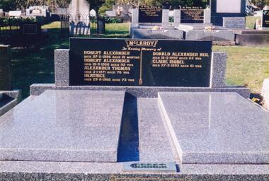 Phillip Island and District Historical Society Inc.
Photograph Album, Kodak, Phillip Island Cemetery, c 1990
... . The property was absorbed by Bass Coast Family Medicine on the west... by Bass Coast Family Medicine on the west side of Warley Avenue ...The Album was compiled by Nancy McHaffie late 1990's, with the assistance of Edith Jeffery's, with her book "Garden of Memories" and extensive knowledge of Phillip Island. The Cemetery lies back from the road and is surrounded by Manna Gums, rare Peppermint Gums, Blackwoods and other native trees. In all 25 acres of land were set aside as Crown Land in the land settlement of 1868. There are 6.2 acres of wetlands near the cemetery entrance.466-56: Alexander McLardy Sr. The descendants of Alex McLardy came to Phillip Island in the year 1886. A builder by trade, he built a great number of houses and buildings on the Island. He was also the founder of the Guesthouse "Glencoe". At 90 years of age he could still read well without the aid of glasses. He died in 1956 aged 95. Others buried in the double graves are: Robert Alexander died 1926 aged 10 months, Alexander Thomas died 1971 aged 76, Beatrice died 1966 aged 73, Donald Alexander died 1992 aged 64 and Claire Isobel died 1993 aged 61. 466-57: Walter Findlay. Walter's parents George and Mary, came to Australia in 1852. Walter was born in Sale circa 1883. He married Henrieta Kennon and they lived and farmed in Settlement Road, Cowes prior to their shop and residence being built in Warley Avenue, Cowes. The shop carried general merchandise and confectionery. The property was absorbed by Bass Coast Family Medicine on the west side of Warley Avenue. Henrieta died September 1965 aged 84. Walter died July 1965 aged 82.phillip island cemetery, alexander mclardy, walter findlay, nancy mchaffie, edith jeffery -
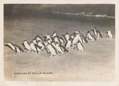 Phillip Island and District Historical Society Inc.
Photographs, 1940's
... umbrellas. Beach west side of the Cowes Pier. Photograph 215-25... and others under beach umbrellas. Beach west side of the Cowes Pier ...12 photographs from a collection of 33 donated by Leonie Brennan. Photographs belonged to Edward (Ted) Sands, hairdresser.Photograph 215-22. Penguins coming home after a day of fishing at the nightly parade Summerland Beach. Photograph 215-23. Pyramid Rock, Phillip Island. Photograph 215-24. Cowes beach with a large group of people gathered together and others under beach umbrellas. Beach west side of the Cowes Pier. Photograph 215-25. Large group of Seals at Seal Rocks, Phillip Island. Photograph 215-26. The Killara Ferry at Cowes pier with chimney smoking. Photograph 215-27. The Pinnacles at Cape Woolamai, Phillip Island. Photograph 215-28. Looking towards the Isle of Wight Hotel at Cowes and the Jetty Shed at the end of the Cowes Pier. Photograph 215-29. The Cowes Pier with the Killara Ferry docked. Photograph 215-30. The Killara Ferry heavily laden with passengers. A close-up showing the back entrance for vehicles. Photograph 215-31. The War Memorial at Cowes looking towards the pier. Shows the pier and the Jetty Shed on the pier. Photograph 215-32. View from inside Forrest Caves, Phillip Island, with two people standing in front. Photograph 215-33. The Nobbies, Phillip Island, with waves crashing onto the rocks.215-22 "Penguins at Phillip Island" 215-23 "Pyramid Rock, Phillip Island" 215-24 "The Beach, Cowes" 215-25 "Seals at Cowes, Phillip Island" 215-26 "The Killara at Cowes" 215-27 "Cape Woolamai, Phillip Island" 215-28 "The Pier, Cowes" 215-29 "The Pier, Cowes" 215-30 "The Killara at Cowes" 215-31 "War Memorial, Cowes" 215-32 "Forest Caves, Phillip Island" 215-33 "Rough seas at The Nobbies, Cowes"penguins coming ashore, penguins, wildlife - penguins, pyramid rock, phillip island, pyramid rock, coastline - rock formation - pyramid rock, cowes beach, phillip island, seals on seal rocks phillip island, wildlife - seals, the killara ferry, killara ferry, the pinnacles, the pinnacles cape woolamai, the pinnacles, phillip island, the isle of wight hotel cowes phillip island, cowes pier, phillip island, cowes jetty, phillip island, war memorial, cowes, phillip island, forrest caves, phillip island, the nobbies, phillip island, mr edward (ted) sands, leonie brennan -
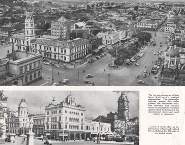 Ballarat Tramway Museum
Photograph - Illustration/s, Ballarat Views, 1950's mid
... printed photo of Pall Mall, Bendigo from west side (by Post Office... west side (by Post Office), looking towards the Shamrock Hotel ...Single sheet of printed paper, collected from a magazine (p59/60) with two black and white photos of Ballarat and one colour of Bendigo. Photo 1 - 260mm long x 122mm high, photo of north east Ballarat from Town Hall, looking out to Black Hill. Photo similar to Reg. No. 102, but buildings on corner of Grenville and Bridge St has a Plume sign instead of a Mobilgas Ad. This indicates early to mid 1950's. One tram in loop in one in Bridge St. Also has a "Neptune" sign in photograph. Photo 2 - 195mm long x 75mm high - from north east corner of Sturt and Lydiard Sts looking towards Town Hall and Craig's Hotel. Photo includes SEC bogie at tram stop and the front end of bus travelling east in Sturt St. Photo 3 - 230mm long x 156mm high - colour printed photo of Pall Mall, Bendigo from west side (by Post Office), looking towards the Shamrock Hotel. Photo includes signs for "COR Motor Spirit", "Tanox Paint" and the rear of a Bendigo to Huntly bus. See item Reg. No. 102trams, tramways, ballarat, bendigo, pall mall, oil companies -
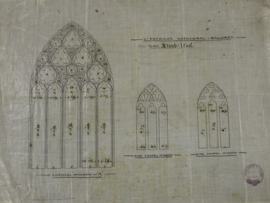 Ballarat Diocesan Historical Commission
Architectural rendering, Architect's rendering of windows/tracery of St Patrick's Cathedral Ballarat
... Renderings of stained west end sanctuary and side altar... Ballarat goldfields Renderings of stained west end sanctuary ...Renderings of stained west end sanctuary and side altar glass windows within traceries for St Patrick's Cathedral Ballarat. The stained glass was designed by James Bentley and manufactured by Clayton and Bell Londond. Installed in 1880 these windows and the sanctuary tiles are the only example of Bentley's artwork outside the British Isles.Only known plans with specifications of Ballarat's St Patrick's Catholic Cathedral major windows. Measurements of glazed portions for stained glass within the traceries. Stamped with the architect's stamp in strap roundel centred with "Architects Melbourne" the firm's name "Tappin Gilbert & Dennehy". -
 Rutherglen Historical Society
Image, 18/05/1892
... Street looking West. on the south side of the street can be seen... of Rutherglen Main Street looking West. on the south side of the street ...Identity of 'Jack' and 'Judy' unknown.Black and white postcard photograph of Rutherglen Main Street looking West. on the south side of the street can be seen the bank at the corner of Main and High Streets, James Tye's fruit and vegetable shop, the Rutherglen Hotel, and the Cumberland Hotel further down the street.Message written on back: "Rutherglen 18/5/92 / Dear Jack, As you can see by the front of this card - Things have been pretty quiet since you have been away! I know that you are on the improve now - and have been walking - so that is great news. Keep up the good work. Haven't sold a bird - yet - have sold a tea towel though. All are missing you at the 'Paris End' of Main Street - so home soon I hope. / Best wishes. Judy."main street, rutherglen hotel, james tye fruiterer -
 Eltham District Historical Society Inc
Photograph, Fay Bridge, Remains of apple orchard near the Diamond Creek, Wattle Glen, 11 October 2018
... past the mine site which was on the west side of the gully... site which was on the west side of the gully a couple ...The newly constructed Diamond Creek Trail from Diamond Creek to Wattle Glen completed in February 2021 winds past these apple trees that possibly lined the entrance to the Greenhills property From Jean Verso, Nillumbik Historical Society, 15 April 2021 William Wandless Herbert bought the surrounding 100 acres in 1852. He was a native of Northumberland and the Scottish Borders who arrived in Melbourne in 1847. The house on the top of the mound would have been built not long after he bought the land; the farm was named "Greenhills". He married Elizabeth Wilson, daughter of John Wilson who had been in Diamond Creek since about 1846. Their first child was born in 1854 so there would be some form of dwelling from about that time. They had eight children who all survived to a good age. His will describes the house as part stone and part wood and of four rooms. Nillumbik Historical Society (NHS) believe it was one of the earliest if not the earliest house, in this part of the district. The remains of the stone house foundations are on top of the mound (photos on the VHD page) and the barn walls are on the north and to the east side of the mound. NHS is not sure how much or which part of the surrounding area was covered by the barns but they were large enough to hold dances after the race meetings that were held in the late 1880's on the adjacent creek flats. It would make sense with the lay of the land that they covered some of the ground to the north and east and used for farm storage, packing sheds for their apple and pear orchards and also for supporting the Nillumbik Gold Mine the family worked to the north up the gully. The path that comes down the gully and runs into the trail goes past the mine site which was on the west side of the gully a couple of hundred metres up from the flats. Heritage Victoria link for the site - https://vhd.heritagecouncil.vic.gov.au/places/12203fay bridge collection, 2018-10-11, diamond creek, diamond creek trail, elizabeth wilson, greenhills, wattle glen, william wandless herbert, apple trees -
 St James Old Cathedral
Cathedral Building, St James Old Cathedral, 09/11/1839
... on each of west and east sides with decorative sanctuary window... stained glass ornamental windows on each of west and east sides ...St James Church, "Church of the Pioneers", was the first Church, first Anglican Church, and is the oldest building in Melbourne. The foundation stone was laid in 1839 by the Superintendent of the District of Bourke, Charles La Trobe, later Governor of the Colony of Victoria. The Church was opened in 1842 and the first Bishop Charles Perry was installed in the Cathedral in 1848 when its status changed to that of Cathedral. Its status changed back to that of a Parish church after 1891 when St Paul's Cathedral in Swanston Street was opened. St James is known as the "Church of the Pioneers" as it served as the place of worship, marriage, baptism and burial of many of the first families in the District of Bourke and the Colony of Victoria. St James Old Cathedral is of the most important historic value to the community of Victoria and to the Australian nation as the first Anglican Church founded within 4 years of the settlement of Melbourne. It represents and conserves the very earliest history of white settlement in Victoria and preserves the church associated history of the Pioneer families of Victoria in its collection of original records and artefacts. Late Neo-Georgian style stone church building with bluestone footings. Octagonal upper one storey bell tower housing eight bells supported by two storey square towers. Body of church has sloping roof and 4 stained glass ornamental windows on each of west and east sides with decorative sanctuary window to the north. Decorative Portico with columns on the north outside elevation. National Trust Commemorative plate on outside wall to right of east entry door. -
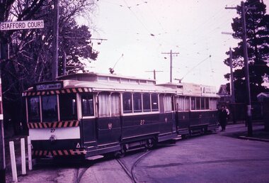 Ballarat Tramway Museum
Slide - 35mm slide/s - set of 7, Noel Simons, 1970's
... closure as a bus stop sign has been positioned on the west side... closure as a bus stop sign has been positioned on the west side ...Set of 7 transparencies taken undated (appear to be 1970 or 71) on PAKON mounts. Also possibly copy slides as quality is poorish. 1175.1 - No. 27 has derailed at Depot, across Wendouree Parade, and No. 33 appears to be about to try and tow it back on. Wendouree Parade totally blocked. Adjacent pole has tram stop sign and has "Stafford Court" street sign mounted on it. 1175.2 - No. 43 at corner of Drummond St. South and Dana Street, with destination Lydiard St. North. 1175.3 - No. 42 (Mt Pleasant) and 21 (Gardens via Sturt St. West) crossing at Gardens Loop. 1175.4 - No. 42 bound for Lydiard St. Nth at intersection with Macarthur St. Shows the retaining wall for the cutting on the east side of Lydiard St. Nth. 1175.5 - No. 43 at corner of Lydiard St and Sturt St., at city terminus showing "Special" and tram 35 adjacent to Post Office in Lydiard St. Nth. Photo shows the small tram stop pole at this location and Post Office building. 1175.6 - No. 39 and 26 and 27 at the Mt Pleasant terminus. Near closure as a bus stop sign has been positioned on the west side of the road. No. 39 showing destination of "Gardens via Sturt St. West" 1175.7 - Nos 21 and 34 crossing at the Grant St. loop in Barkly St. 21 has destination of Mt Pleasant, while 34, - Gardens via Sturt St. West"All information on typed small white labels, on the top of the slides using black ink. 1175.1 - "27 derailed and 33 at depot" 1175.2 - "43 at cnr Drummond & Dana Sts" 1175.3 - "21 and 42 Gardens Terminus" 1175.4 - "42 at cnr Macarthur & Lydiard" 1175.5 - "43 & 35 at Post Office" 1175.6 - "39, 26 and 27 at Mt Pleasant" 1175.7 - "21 & 34 at Grant St"tramways, trams, wendouree parade, depot, accidents, derailments, drummond st. sth, gardens loop, post office, mt pleasant, grant st., tram 21, tram 26, tram 27, tram 33, tram 35, tram 42, tram 43 -
 Ballarat Tramway Museum
Photograph - Digital image Set of 11, Stuart Loddington, 10 images of Ballarat trams prior to closure, 1971
... terminus, taken from the west side of the Buninyong Rail line... at Victoria St terminus, taken from the west side of the Buninyong ...Yields information about Ballarat Tramways and trams prior to the closure of the tramway system.Set of 11 digital images, comprising 1 donation text image and 10 images of Ballarat trams prior to closure, scanned from original slides by Stuart Lodington, 1971 prior to closure of the system. .1 - Donation text slide. .2 - No. 26 southbound in Lydiard St North, with the Ballarat Railway Station level crossing gates in the background. .3 - No. 27 and 30 crossing at Bell St Loop, Skipton St. (see also btm4976i4) .4 - No. 17 Wendouree Parade, near Gardens Loop .5 - Single truck tram at Victoria St terminus, taken from the west side of the Buninyong Rail line bridge, with CRB Roadwork sign, Eureka Caravan Park and Meagher Hotel in the background, possibly No. 11, see entry for .10 .6 - No. 12 and 30 crossing at the Urquhart St Loop, Drummond St South. .7 - No. 12 westbound in Sturt St, with Grenville St in the background. .8 - No. 17 at Gardens Loop with the Trolley pole being reversed. .9 - No. 30, Lydiard St North with Reid's Palace building in the background. .10 - No. 11 passing over the Buninyong rail line bridge, with Gardens via Sturt St West and a Twin Lakes sign. Has a number of children alongside the driver. .11 - No. 21 heading northbound in Wendouree Parade, Gardens, just to the north of the now BTM depot junction.trams, tramways, ballarat, level crossings, buninyong railway, lydiard st north, bell st, victoria st, wendouree parade, gardens, drummond st, sturt st, tram 26, tram 27, tram 30, tram 17, tram 12, tram 21, tram 11 -
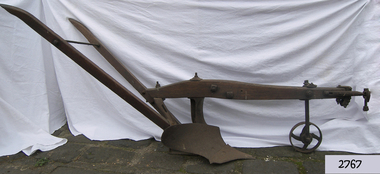 Flagstaff Hill Maritime Museum and Village
Tool - Plough, Syracuse Chilled Plow Co, 1876-1900
... covered a square block on the cities Near West Side. In 1910-11... block on the cities Near West Side. In 1910-11, Deere ...The Syracuse Chilled Plough Company was created in 1876 and specialised in the manufacture of agricultural ploughs. Harry Wiard invented the chilling process in plough manufacture. The company was originally founded as the Robinson Chilled Plough Company in 1876 and changed its name 3 years later. At its peak, in the early 20th century. The company made more than 100,000 horse-drawn ploughs and road scrapers of various designs that were sold from the Syracuse plant each year and exported around the world. The company slogan of the day was, “The sun never sets on a Syracuse plough." Eventually, other farming implements were added to the line. The company employed more than 300 people in its local plant, which covered a square block on the cities Near West Side. In 1910-11, Deere and Company began expanding its holdings, and with the success of the Syracuse Chilled Plough Company, Deere sought to acquire the company. The management of the Syracuse operation after John Deere took over remained in the hands of Wiard and Chase, and the manufacturing operations were left in Syracuse. The only change from previous Syracuse operations was the selling of the companies products through Deere retail outlets instead of directly to the trade. The factory in Syracuse continued to produce ploughs until 1955. The subject item in the Flagstaff collection is an early model Syracuse Chilled plough with a wooden beam frame it is very much lighter in weight and was adapted to work sandy or light loamy soil. This plough has a sloping landside, which tends to keep the clods and dirt from falling into the furrow, making the ploughman's work much more comfortable and easy. This design was made in eight sizes for both right and left-handed ploughing and became very popular in the far West and South of the USA. Note: The definition of a chill plough means : a plough having the share and mould-board of chilled semi steel or cast iron.The subject item is believed to be a very early plough given its wooden beam frame and was made before 1900 probably around 1880. This makes it a significant example of the types of plough that early settlers were using in Victoria. There would not be very many of this type of vintage plough left with a wooden beam and frame, making it today a desirable collector's item. Syracuse Wood Beam Chilled single furrow plough metal wheel in front. Syracuse Chiller Co Syracuse & 50 L stamped on ploughshare.flagstaff hill, warrnambool, shipwrecked-coast, flagstaff-hill, flagstaff-hill-maritime-museum, maritime-museum, shipwreck-coast, flagstaff-hill-maritime-village, plough, syracuse chiller co, chiller plourh, farm equipment, furrow -
 Eltham District Historical Society Inc
Photograph, Fay Bridge, Ruins beside the Diamond Creek at Wattle Glen, 13 October 2016
... past the mine site which was on the west side of the gully... site which was on the west side of the gully a couple ...The newly constructed Diamond Creek Trail from Diamond Creek to Wattle Glen completed in February 2021 winds around these ruins just pass the high transmission power lines near Herberts Lane and Collard Drive From Jean Verso, Nillumbik Historical Society, 15 April 2021 William Wandless Herbert bought the surrounding 100 acres in 1852. He was a native of Northumberland and the Scottish Borders who arrived in Melbourne in 1847. The house on the top of the mound would have been built not long after he bought the land; the farm was named "Greenhills". He married Elizabeth Wilson, daughter of John Wilson who had been in Diamond Creek since about 1846. Their first child was born in 1854 so there would be some form of dwelling from about that time. They had eight children who all survived to a good age. His will describes the house as part stone and part wood and of four rooms. Nillumbik Historical Society (NHS) believe it was one of the earliest if not the earliest house, in this part of the district. The remains of the stone house foundations are on top of the mound (photos on the VHD page) and the barn walls are on the north and to the east side of the mound. NHS is not sure how much or which part of the surrounding area was covered by the barns but they were large enough to hold dances after the race meetings that were held in the late 1880's on the adjacent creek flats. It would make sense with the lay of the land that they covered some of the ground to the north and east and used for farm storage, packing sheds for their apple and pear orchards and also for supporting the Nillumbik Gold Mine the family worked to the north up the gully. The path that comes down the gully and runs into the trail goes past the mine site which was on the west side of the gully a couple of hundred metres up from the flats. Heritage Victoria link for the site - https://vhd.heritagecouncil.vic.gov.au/places/12203fay bridge collection, 2016-10-13, diamond creek, diamond creek trail, ruins, wattle glen, william wandless herbert, greenhills, elizabeth wilson -
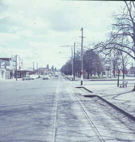 Ballarat Tramway Museum
Slide - 27 mm sq slide/s - set of 5, Lilian Butler, Sturt Street, 1971
... - Sturt St looking west, south side from Windermere St. .2 - ditto... - Sturt St looking west, south side from Windermere St. .2 - ditto ...Yields information about Sturt St between Lydiard St and Ripon St.Set of 5 AGFA slides - blue and white plastic mounts: 1 - Sturt St looking west, south side from Windermere St. .2 - ditto from Dawson St, shows tram stop sign and end of section sign. .3 - ditto from Armstrong St - with Myer's and Coles stores in the background. .4 - ditto at Ripon St, showing junction of View Point line, has the shelter on the right. .5 - City terminus - Sturt St and Lydiard St, with a bogie tram arriving from Grenville St. Has the ESCo switch box in the view - (to the right of the ladies). Has the Commonwealth Bank on the right hand side of the photo. Photo from the collection of Lilian Butler. ballarat, tramways, trams, sturt st, dawson st, tram stops, view point, shelters, lydiard st