Showing 13708 items
matching wye-river-bridge
-
 Eltham District Historical Society Inc
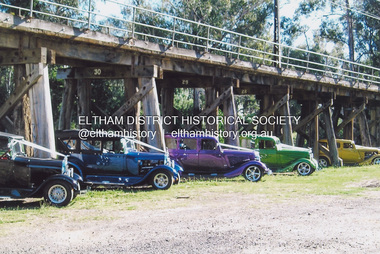
Photograph, Fay Bridge, Hot Rods at the Eltham Railway Trestle Bridge, n.d
fay bridge collection, eltham, eltham railway trestle bridge, trestle bridge, eltham trestle bridge, hot rods -
 Eltham District Historical Society Inc
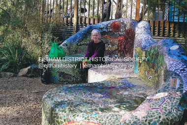
Photograph, Fay Bridge, Fay Bridge with the Lasting Memories Mosaic Seat, St. Andrews Hall, 1 Proctor Street, St. Andrews, n.d
The Lasting Memories Mosaic Group Seat is part of Nillumbik Shire Council's Public Art. Following the Black Saturday Bushfire of February 7, 2009, which ravaged St Andrews and surrounding district, a group of bushfire affected women formed the Lasting Memories Mosaic group and created this concrete seat covered in mosaic as part of their healing process. It was completed in 2012. For more information see Nillumbik Shire Council's link Public Art: Lasting Memories Mosaic GROUP, Lasting Memories Mosaic Seat - https://victoriancollections.net.au/items/58536395d0ce201b746561c6fay bridge collection, fay bridge, mosaics, st andrews, lasting memories mosaic group seat, st andrews hall -
 Eltham District Historical Society Inc
Photograph, Fay Bridge, Maurice Hurry, Fay Bridge and Damian Skipper, 2016
fay bridge collection, damian skipper, eltham town square, fay bridge, maurice hurry, safeway supermarket, 2016 -
 Eltham District Historical Society Inc
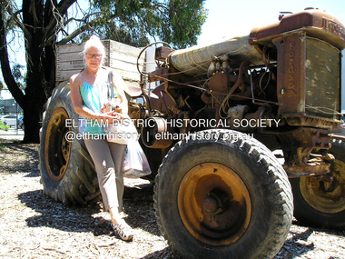
Photograph, Fay Bridge, Fay Bridge with Fordson Tractor at H.Aumann & Sons. Fruit &/or Berry Growers. 246 Tindals Rd, Warrandyte, 29 January 2018
fay bridge collection, 2018-01-29, fay bridge, fordson tractor, h. aumann & sons, warrandyte -
 Ringwood and District Historical Society
Photograph, Mullum Creek from bridge in Warrandyte Rd. Looking East 1970
From bridge in Warrandyte Road. See DB Item 2957 for later photo, same scene, with bridge identified.Typed below photograph, "Mullum Creek 1970 from bridge" -
 Tatura Irrigation & Wartime Camps Museum
Photograph, Eildon Reservoir - Goulburn River, 1918
Taken by photographer for State Rivers and Water Supply Commission.Medium sized black and white photograph. Eildon Reservoir on the Goulburn River / Overall picture of dam (Right of wall) filled with water and some leisure craft moored near shore and huts / Dam wall and spillway / tree covered hills beyond"Eildon Reservoir - Goulburn River / Capacity - 306,000 acre feet / Rock filled dam with mass concrete spillway / Total length of dam - 3000 feet / Maximum depth of water - 123 feet - etc"victorian state rivers and supply commission, eildon dam -
 Rutherglen Historical Society
Book, Kath Bentley et al, River of Islands: Charts of the River Murray Yarrawonga Weir to Hume Dam, November 1983
Book contains information and sketch maps to aid in the navigation of the Murray River, with advice on hazards to look for as these will change over time.74 page A4 book with a drawing of a boat on the Murray River on the coverAutographed on the title page by the authors: "9-1-84 Leon Bentley | Kath Bentley"murray river, boating, river navigation, boating safety -
 Ballarat Heritage Services
Photograph - Photograph - Colour, Clare Gervasoni, Brembo River, Near San Giovanni Bianco, Lombardy, Italy, 2001, 2001
The Brembo River is a 74-kilometer river which runs entirely within the Province of Bergamo in the Lombardy Region of Italy.Colour photograph of the Brembo River.brembo river, san giovanni bianco, italy -
 Ballarat Heritage Services
Photograph - Photograph - Colour, Clare Gervasoni, Nimon's Bridge, 1999, 04/10/1999
Nimons Bridge was built in 1890, as part of the then Ballarat-Linton railway. The bridge is 17 spans with tall timber piers of four driven piles each, with triple sets of diagonal cross-bracing and walers and a single row of longitudinal horizontal bracing between piers. The spans are of a uniform twenty feet (6.1 metres), originally supported by four 21-inch x 9-inch (535 mm x 230 mm) Kauri timber beams per span, following the standard V.R. design of the period. When the superstructure was rebuilt after the 1953 fire, the timber beams were replaced with two 24-inch (610mm) deep rolled-steel-joists on each span. These are marked 'Lancashire Steel Co., Scotland' and are believed to have been second-hand. The deck of transverse-timber planks is 103.6 metres in length. Overall the bridge has an impressive appearance with its exceptionally tall triple-cross-braced piers creating a 'three-tiered' effect, with the deck 19.2 metres above the Woady Yaloak River. The Ballarat-Skipton line closed in 1985. Nimons Bridge has been recently restored, as part of the Ballarat-Skipton Rail Trail. How is it significant? Nimons Bridge is significant for technical, historic and aesthetic reasons at a State level. Why is it significant? Nimons Bridge is technically significant as Victoria's fourth-tallest timber trestle bridge when built, and as the third-tallest surviving example. It is also the second-largest composite bridge combining traditional timber piers with RSJ spans and a timber deck and falls within a select group of fewer than ten timber railway bridges with horizontal longitudinal bracing between the piers and three sets of double cross-bracing on its tallest piers, creating a visually striking 'three tiered' effect that enhances its viaduct form. Nimons Bridge is historically significant as having served initially the mining community at Linton, then the Western District agricultural area and in later years a kaolin quarry at Pittong. Nimons Bridge is historically significant as a representative of the 'light' branch line methodology that stimulated the explosion of railway construction in Victoria during the 1880s, and provides an interesting contrast with the more solid and vastly more expensive railway viaducts built in similar terrain on Victorian main lines, at Moorabool and Taradale, in the late 1850s. Approached by a deep cutting and high embankment at either end, the bridge represents a very cost-effective late 19th century engineering solution to the characteristic physiography of western Victoria with flat basalt plains intersected by deep wide valleys occasionally subject to severe flooding. Nimons Bridge is aesthetically significant for its visually impressive viaduct form, crossing a deep and steep-sided valley that is part of a rich cultural landscape. Within close proximity of the bridge are mullock dumps, tailings, shaft sites and other relics of the deep-lead alluvial mining era. The bridge is the most visually spectacular timber-trestle rail bridge in Western Victoria and is among the most spectacular timber-trestle rail bridges surviving anywhere in Victoria. It is part of the Ballarat-Skipton Rail Trail. Classified by the National Trust :02/10/2000 (http://vhd.heritagecouncil.vic.gov.au/places/67986)Colour photograph of a log bridge known as Nimon's Bridge.ballarat-linton, nimons bridge, nimon's bridge, log bridge, viaduct, timber-trestle rail bridge -
Hume City Civic Collection
Photograph, Macedon Street Bridge, 1986
The photograph was taken showing the underside of the Macedon Street Bridge which spans the Jacksons Creek. It was constructed in the second half of the 1800s and replaced a pontoon that was used for river crossings.This is one of the five historic bridges which have been constructed in Sunbury.A non- digital black and white photograph of two arched bluestone bridge spanning a watercourse.macedon street bridge, bridges, jacksons creek -
 Orbost & District Historical Society
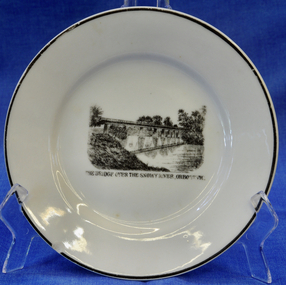
plate
This item is an early souvenir of the local district.Small white plate with black rim. Black and white illustration of the bridge over the Snowy River at Orbost.Back - Made in Orbost. Front - The Bridge Over The Snowy River At Orbost, Vic.plate souvenir snowy-river orbost -
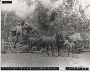 Lorne Historical Society
Photograph - Black and white photograph, mounted, Coach & Team, Sam Clissold driver. Lorne Bridge
Print mounted on board showing coach crossing Erskine RiverCoach & Team - Sam Clissold driver. Lorne Bridgebridge, coach, sam clissold, clissold, lorne bridge, horse driven, 1617, erskine, coach-driver -
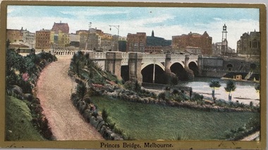 Kew Historical Society Inc
Postcard, Princess Bridge, Melbourne, c.1907
The Kew Historical Society's postcard collection includes views of Kew, Melbourne and Greater Melbourne as well as those including overseas scenes sent or received from Europe or the Middle East. They date from the 1890s to the 2000s. These postcards may or may not include the name of the publisher or printer. A number of the cards were published as parts of popular series. A way of dating early postcards is to identify whether the reverse was divided by a central line which became the norm after 1902 in the United Kingdom. However, other postcards produced after this date do not always conform to this print layout.Rare variant version of this view of Princes Bridge, from the south-east bank of the Yarra River, looking towards the city of Melbourne, showing landmarks of the period.Polychrome postcard of Princess Bridge in Melbourne.Princess Bridge, Melbourne Miss McGilivray, "Oak Bank", Peterborough, _____. princess bridge -- melbourne (vic.), river yarra, postcards -- melbourne (vic.) -
Stawell Historical Society Inc
Painting, Will Rees, Water colour of property at Dadswells Bridge
Property painted was Bill & Jean (Cumming) Howards. They were beekeepers & farmers at Dadswells Bridge. Jeans father was a friend of Will Rees. Audrey's (donor) husband Bob Cummings was raised by the Howards from age of 9.Watercolour Painting by Will Rees Stawell artist. Landscape trees two buildings & sheep. Property at Dadswells Brudge. In brown Frame, reflective glassSigned by Will Reespainting, artwork -
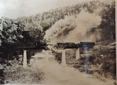 Kew Historical Society Inc
Postcard, Walhalla Train Crossing Thomson Bridge, c.1910
One of a number of 'real photo' and commercial postcards created by or owned by members of the Christian and Washfold families of Kew. The postcards are part of a larger collection of photographs, postcards and publications donated to the collection in May 2021.Small black and white 'real postcard' of the Walhalla Train crossing the Thomson Bridge.Walhalla Train Crossing Thomson Bridgehenry christian (1886-1962), landscape photography, thomson river (vic.), thomson bridge (vic.), trains -- walhalla -- victoria, christian-washfold collection -
 Eltham District Historical Society Inc
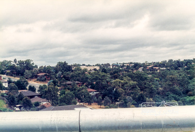
Photograph, Looking west across the new 5-span bridge construction across the Plenty River from near Plenty River Drive; Greensborough Bypass construction, c.1986, 1986c
Colour photograph originally located in a magnetic style album titled 'Greensborough Bypass 1990s 5' suffering significant degradation. No information contained in album or on reverse of photos except where noted. Relocated to archival photosafe storage.greensborough bypass, road construction, greensborough, plenty river drive, bridge construction -
 Eltham District Historical Society Inc
Photograph, Looking south onto the Plenty River Trail Reserve from the new bridge ove the Plenty River; Greensborough Bypass construction, c.1986, 1986c
Colour photograph originally located in a magnetic style album titled 'Greensborough Bypass 1990s 5' suffering significant degradation. No information contained in album or on reverse of photos except where noted. Relocated to archival photosafe storage.greensborough bypass, road construction, greensborough, plenty river drive, plenty river trail -
 Eltham District Historical Society Inc
Photograph, Looking south onto the Plenty River Trail Reserve from the new bridge ove the Plenty River; Greensborough Bypass construction, c.1986, 1986c
Colour photograph originally located in a magnetic style album titled 'Greensborough Bypass 1990s 5' suffering significant degradation. No information contained in album or on reverse of photos except where noted. Relocated to archival photosafe storage.greensborough bypass, road construction, greensborough, greensborough plaza -
Tramways/East Melbourne RSL Sub Branch - RSL Victoria Listing id: 27511
Book, Octopus, Great War Stories (Colditz Story, Bridge over River Kwai, Battle of the River Plate, Dambusters), 1978
isbn: 0 7064 0926 4 -
 Ballarat Heritage Services
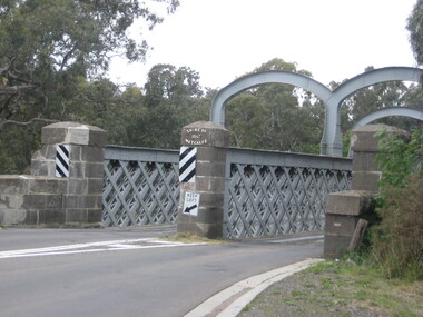
Photograph, Redesdale Bridge, 2016, 18/01/2016
The Redesdale Bridge is a wrought iron and timber structure with bluestone abutments which was installed over the Campaspe River in January 1868, although the bridge actually bears the date 1867. In 1859, the "Herald of the Morning", a ship carrying a cargo including 350 tons of ironwork for the Hawthorn bridge, caught fire and was scuttled a quarter of a mile off the jetty at Sandridge. A Melbourne salvaging firm raised the ironwork from the bottom of the bay, but after details of an arranged sale to the government caused a scandal in Parliament, the material was sold privately to the Melbourne foundry Langlands & Co. Two hundred tons of it was sold to the goldfields shires of McIvor and Metcalfe for only £1000. The bridge was designed by engineer T.B. Muntz and built by a contractor named Doran, and was completed late and considerably over budget at £6274. The bridge spans 45.7m across the river and has two roadways which are carried between three metal lattice girders in a through truss configuration. The design for the Hawthorn bridge had the deck supported over the trusses, and to stiffen the through truss configuration three sets of distinctive paired arches connect the trusses above the roadways. The roadway decking is constructed of longitudinally placed timbers on timber cross girders which rest on the lower chords of the trusses. (Heritage Victoria) A number of colour photographs showing the historic bridge at Metcalfe.metcalfe, shire of metcalfe, bridge, municipal boundary, shire of mcivor, redesdale bridge, campaspe river, t.b. muntz, doran -
 Marysville & District Historical Society
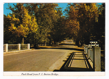
Postcard (item) - Colour postcard, Nucolorvue Productions Pty. Ltd, Pack Road from F.J. Barton Bridge, Pre 2009
A colour photograph of Murchison Street from the F.J. Barton Bridge in Marysville in Victoria.A colour photograph of Pack Road from the F.J. Barton Bridge in Marysville in Victoria. Labeling is incorrect. The view is looking down Murchison Street from the F.J. Barton Bridge. The F.J. Barton Bridge was named after Frederick John Barton. The Barton Family were amongst Marysville's first pioneering families. This postcard was published by Nucolorvue Productions as a souvenir of Marysville.NU-COLOR-VUE/ OF / AUSTRALIA MARYSVILLE, VICTORIA. Pack Road from F.J. BARTON/ BRIDGE. PLACE/ STAMP/ HERE POST CARD NCV.172 - NUCOLORVUE PRODUCTIONS PTY. LTD./ COPYRIGHT Printed in Australia (Note our new/ bridge) Hullo Dot,/ Very pleased to/ have the chance to meet someone who/ can tell us your news. All the best from/ all the family here at Marysville/ Terry. Dear Dot,/ Good to hear/ first hand news/ of you. Regards,/ Elsie Walkermarysville, f.j. barton bridge, murchison street, victoria, postcard, souvenir, nucolorvue productions, fj barton -
 Greensborough Historical Society
Slide - Photographic Slide, Swing bridge Greensborough, 1974
View of swing bridge Greensborough following 1974 Plenty River flood. Includes Diamond Valley Council clean-up crew of Lindsay Millington and M. SmeadKodachrome colour photographic slideHandwritten on mount: "Swing bridge Greensboroiugh; 1974 flood; L Millington; M Smead"plenty river flood, swing bridge greensborough, lindsay millington -
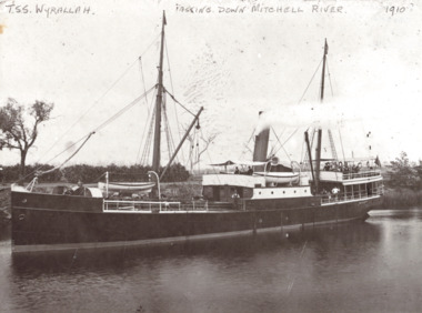 Lakes Entrance Historical Society
Photograph, TSS Wyrallah on Mitchell River, Bairnsdale Victoria, 1910
Black and white photograph of the TSS Wyrallah with crew and passengers standing on after deck while steaming slowly down the Mitchell River near Bairnsdale VictoriaTSS Wyrallah Passing down Mitchell River 1910boats and boating, rivers, gippsland lakes -
 Marysville & District Historical Society
Postcard (item) - Colour postcard, Souvenirs Australia Pty. Ltd, A Ford on the Acheron River, 1881, Post 1995
A postcard from a painting of a ford on the Acheron River that was painted in 1881 by H.J. Johnstone.A postcard from a painting of a ford on the Acheron River that was painted in 1881 by H.J. Johnstone. The original painting is oil on canvas and was donated to the Broken Hill City Art Gallery in 1948 by Mr. O. Von Rieben. This postcard was produced by Souvenirs Australia Pty. Ltd. in Glynde, South Australia as a souvenir of Marysville.H.J. JOHNSTONE/ A FORD ON THE ACHERON RIVER, 1881/ OIL ON CANVAS, 171cm x 245cm/ BROKEN HILL CITY ART GALLERY/ DONATED BY MR. O. VON RIEBEN, 1948 Made in/ Australia by/ Souvenirs Aust./ Pty. Ltd./ Adelaide/ BHG 2 ADDRESS Published by/ Souvenirs Australia Pty. Ltd./ Glynde/ Copyright A PITT CARDacheron river, oil painting, h.j. johnstone, broken hill city art gallery, mr. o. von rieben, postcard, souvenirs australia, souvenir -
 Ballaarat Mechanics' Institute (BMI Ballarat)
Film - Photograph by Herb Richmond. ca 1971, Yendon Blue Bridge- Road Bridge over the Moorabool River
Ballarat History35mm B&W Kodak Plus X Pan Film.ballarat, ballaraat, yendon, bridge, moorabool -
![Fern Bridge Gully, Black Spur / [by] Nicholas Caire, circa 1876](/media/collectors/550653872162f11fb04854aa/items/577b4c16d0cdd10948c8afab/item-media/577b4c75d0cdd10948c8ebe0/item-fit-380x285.jpg) Kew Historical Society Inc
Kew Historical Society IncPhotograph, Anglo-Australasian Photographic Company, Fern Bridge Gully, Black Spur, c. 1876
Nicholas Caire was born on Guernsey in the Channel Islands in 1837. He arrived in Adelaide with his parents in about 1860. In 1867, following photographic journeys in Gippsland, he opened a studio in Adelaide. From 1870 to 1876 he lived and worked in Talbot in Central Victoria. In 1876 he purchased T. F. Chuck's studios in the Royal Arcade Melbourne. In 1885, following the introduction of dry plate photography, he began a series of landscape series, which were commercially successful. As a photographer, he travelled extensively through Victoria, photographing places few of his contemporaries had previously seen. He died in 1918. Reference: Jack Cato, 'Caire, Nicholas John (1837–1918)', Australian Dictionary of Biography.An original, rare photograph from the series 'Views of Victoria: General Series' by the photographer, Nicholas Caire (1837-1918). The series of 60 photographs that comprise the series was issued c. 1876 and reinforced a neo-Romantic view of the Australian landscape to which a growing nationalist movement would respond. Nicholas Caire was active as a photographer in Australia from 1858 until his death in 1918. His vision of the Australian bush and pioneer life had a counterpart in the works of Henry Lawson and other nationalist poets, authors and painters.Views of Victoria (General Series), No.22 / ‘Fern Bridge Gully, Black Spur’ / Albumen silver photograph mounted on boardInscription on reverse: 'Fern Bridge Gully is situated near the summit of the Black Spur, about two miles from Fernshawe. Here the foliage is exceedingly dense, so much so as to exclude daylight in many places. This stream has derived its name from the fact of the Bridge having been constructed of large massive fern tree. The stream which flows beneath the Bridge is one of the sources of the River Watt.’nicholas caire (1837-1918), australia - landscape photography -
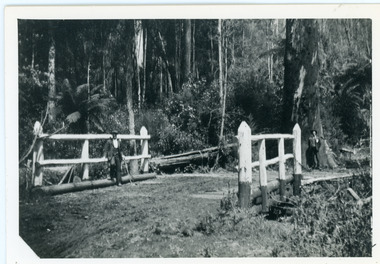 Mt Dandenong & District Historical Society Inc.
Photograph, Barber's Bridge on Olinda Creek
John Lundy-Clarke grew up in the Kalorama/Mt Dandenong area and later in life (1972-74) began to write a comprehensive history of the area working from an original settlement map in an effort to cover all areas. Barbers Bridge was named after George Barber, an early settler.Black and white photograph showing a man standing on a bridge over the Olinda Creek. 1910Handwritten n reverse: Barbers Bridge on Olinda Creek 1910. This was a ford crossed by the road after Isaac Jeeves selected allotment “C” “Jeeves Saddle” in 1871 and stopped travel through his property. The bridge has been built several times but at time of writing (1974) is replaced by a culvert consisting of two pipes two feet six inches wide. They are quite incapable of carrying the maximum flow of the creek and will be swept away.lundy-clarke, barber, barbers bridge, isaac jeeves, jeeves saddle, bridge, olinda creek -
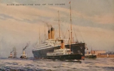 Kew Historical Society Inc
Postcard, Valentine's Series, River Mersey - The End of the Voyage, c.1928
Collection of thirty-nine postcards donated by Jillian Rigby which had been owned by her grandparents, George and Edith Weir, who from c.1917 lived at 84 Princess Street, Kew. The mostly 'mint' postcards were purchased in Victoria and while travelling overseas. The sole dated postcard is dated from 1929. The postcards are numbered sequentially from 2017.0058.01-39. The remainder of the collection donated by Jill Rigby which was once owned by the Weirs of Broken Hill and Kew consist of costumes, costume accessories, photographs, and documents.The postcards in the Weir collection, especially those purchased on a trip or trips to the mother country, i.e. United Kingdom, represent a representative sample of sites that were considered significant to those Australians undertaking a reverse grand tour by member of the erstwhile colonies. Those postcards which are early views of Melbourne must have been produced commercially for some decades from the early part of the 20th century.River Mersey - The End of the Voyage. One of a set of three [originally six] 'High Class Postcards of Memories of the Mersey, Beautifully Reproduced in Nature Colours', in their original brown envelope. The postcard was probably purchased by George and Edith Weir on a trip to England and Scotland, circa 1928."River Mersey - The End of the Voyage"postcards, george and edith weir, river mersey, postcards -- uk, weir collection -
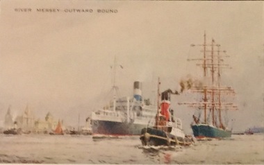 Kew Historical Society Inc
Postcard, Valentine's Series, River Mersey - Outward Bound, c.1928
Collection of thirty-nine postcards donated by Jillian Rigby which had been owned by her grandparents, George and Edith Weir, who from c.1917 lived at 84 Princess Street, Kew. The mostly 'mint' postcards were purchased in Victoria and while travelling overseas. The sole dated postcard is dated from 1929. The postcards are numbered sequentially from 2017.0058.01-39. The remainder of the collection donated by Jill Rigby which was once owned by the Weirs of Broken Hill and Kew consist of costumes, costume accessories, photographs, and documents.The postcards in the Weir collection, especially those purchased on a trip or trips to the mother country, i.e. United Kingdom, represent a representative sample of sites that were considered significant to those Australians undertaking a reverse grand tour by member of the erstwhile colonies. Those postcards which are early views of Melbourne must have been produced commercially for some decades from the early part of the 20th century.River Mersey - Outward Bound. One of a set of three [originally six] 'High Class Postcards of Memories of the Mersey, Beautifully Reproduced in Nature Colours', in their original brown envelope. The postcard was probably purchased by George and Edith Weir on a trip to England and Scotland, circa 1928."River Mersey - Outward Bound"postcards, george and edith weir, river mersey, postcards -- uk, weir collection -
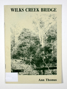 Marysville & District Historical Society
Book, Wilks Creek Bridge, 1993
A history of the Wilks Creek Bridge and its connection to the Yarra TrackPaperback. Front cover has an old photograph of the Wilks Creek Bridge.Dear Reader, The pen has only to select one of the many stages of building old Yarra Track,/ for a colorful story subject. The Track, first established in the early 1860's to/ serve goldseekers making their hazardous way to the rich Wood's Point goldfields,/ extended some 160km from Eltham - in Melbourne's northern region to Woods/ Point in the eastern ranges. I hope a glimmer of the excitement of those times comes through as I draw/ your attention to old Wilks Creek bridge and its picnic spot to be found 3.5km/ west of Marysville. Once part of Yarra Track and now superseded by a modern/ roadway alongside, the old bridge with its solid masonry walls either side of the/ cold, pure stream makes a pleasing scene for the visitor. With much pleasure/ I dedicate this narrative to Marysville and District Historical Society./ Ann Thomas Stamp of Marysville & District / Historical Society Inc / P.O. Box 22 / Marysville 3779wilks creek, marysville, yarra track, victoria, history, local history