Showing 27614 items
matching yarra-river
-
 University of Melbourne, Burnley Campus Archives
Booklet - Brochure, The Yarra Trail; a history of Richmond's river, 198-?
Brochure produced by City of Richmond and Vic. Ministry for Planning & Housingyarra trail, richmond, yarra river -
Koorie Heritage Trust
Book, Brown, Rik, The upper Yarra River corridor : sites of conservation significance, 1993
179 p.; maps; appendices; 30 cm.environmental protection -- victoria -- yarra river region. floodplain management -- victoria -- yarra river region. ecology -- victoria -- yarra river region. biodiversity conservation -- victoria -- yarra river region. yarra river region (vic.) -
 Ballarat Heritage Services
Aerial digital photograph, L.J. Gervasoni, Mouth of the Yarra River and Westgate on approach to Melbourne's Tullamarine Airport, 2016
hoto taken from flight in to Melbourne International airport.Digital aerial image of Melbourne, Victoria.aerial, landscape, cityscape, mouth, yarra river, west gate bridge, aerial photograph -
 Ballarat Heritage Services
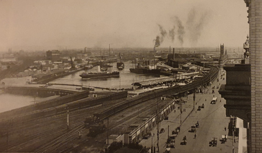
Image, Melbourne Port on the Yarra River, c1918, c1918
Black and white image of the Port of Melbourne.port of melbourne, yarra river, melbourne, immigration, boats, ships -
Kew Historical Society Inc
Book, Book Collectors' Society of Australia, Batman & Fawkner: Discovery of the River Yarra; an episode, 1965
Originally printed by H. Cordell, 59 Queen St., 1881. Limited edition of 250 copies11 p. 2 facsims. 23 cm. non-fictionOriginally printed by H. Cordell, 59 Queen St., 1881. Limited edition of 250 copiesbatman john -- 1801-1839, fawkner john pascoe -- 1792-1869, melbourne (vic.) - history - 1834-1851. -
 Kew Historical Society Inc
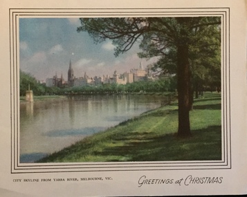
Card, Greetings at Christmas - City skyline from Yarra River Melbourne, 1955-65
An item from an outstanding and diverse collection, assembled by members of the Christian and Washfold families of Kew.Colour print used as a greeting cardpostcards -- melbourne, christian-washfold collection -
 Kew Historical Society Inc
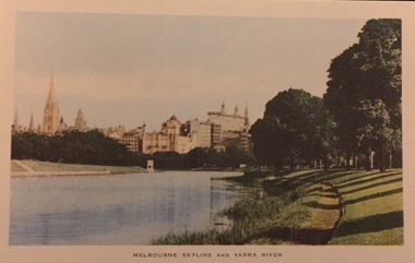
Postcard, Nucolorview Productions, Melbourne Skyline and Yarra River
One of a number of 'real photo' and commercial postcards created by or owned by members of the Christian and Washfold families of Kew. The postcards are part of a larger collection of photographs, postcards and publications donated to the collection in May 2021.Coloured matte postcard with skyline including State Theatre (Forum) in distance.postcards -- melbourne, yarra river, christian-washfold collection -
University of Melbourne, Burnley Campus Archives
Photograph - Colour postcard, Burnley Ferry, River Yarra, c. 1912
Copy of a postcard taken from the State Library of Victoria website. Shows the ferry which would have operated from near Burnley Campus. Dated ca.1912. Note this is Copyright.state library of victoria, ferries, burnley campus, yarra river -
 City of Greater Geelong
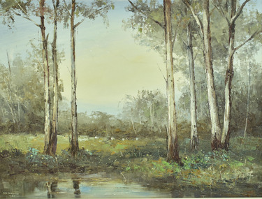
Oil on Hardboard, Wim Portland, Yarra River
-
 Wonga Park Community Cottage History Group
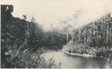
Photograph (sub-item) - Black and White, ‘Horseshoe Bend’ on the Yarra River at Wonga Park, in 1929, 1929
-
Wonga Park Community Cottage History Group
Work on paper (Item) - Report, Undated Review of Statement of Planning Policy Nos. 3 & 4 Dandenong Ranges and River Yarra: Supplementary Report on the Policy Areas
-
![Photograph (sub-item) - Black and White, A view up the Yarra River from Wonga Park in the 1940’s. [Scouts on Mount Lofty looking upstream] ??, late 1940s](/media/collectors/5c7716e021ea6a1a60039fee/items/63185440823216272c277dad/item-media/63185498823216272c2785f4/item-fit-380x285.jpg) Wonga Park Community Cottage History Group
Wonga Park Community Cottage History GroupPhotograph (sub-item) - Black and White, A view up the Yarra River from Wonga Park in the 1940’s. [Scouts on Mount Lofty looking upstream] ??, late 1940s
-
 Park Orchards Community House
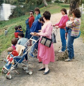
Photograph, Park Orchards Community Centre & Learning Centre Playgroup 1984, strolling with parents along Yarra River
-
 Eltham District Historical Society Inc
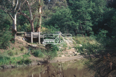
Slide - Photograph, Viewing platform near the confluence of Diamond Creek and Yarra River, c.Nov. 2001
In October 1996 the viewing platform was opened. It is situated near Lenister Farm on the Diamond Creek trail. It was a joint project involving Nillumbik Shire Council, Skill Seekers Inc., Department of Natural resources and Environment and Department of Employment, Education, Training and Youth Affairs. The platform was officially opened by Don Cordell Chairman of Commissioners. Part of a slide show presentation "A Trip Down the Diamond Creek" by Russell Yeoman to the Eltham District Historical Society meeting of 14 Nov. 200135mm colour positive transparency Mount - Black and Whiteconfluence, diamond creek, yarra river, viewing platform -
 Marysville & District Historical Society
Photograph (Item) - Black and white photograph, Yarra Track Hotel, c1900
An early black and white photograph of a hotel along the Yarra Track.An early black and white photograph of a hotel along the Yarra Track. The Yarra Track is the former name of the gold fields road from Healesville to the Woods Point and Jordan Goldfields, in Victoria, Australia. A direct route via the Yarra River and the Great Divide was discovered by Rieck in September 1862 and became known as the Yarra Track. Early in 1863, the Victorian Government decided to construct a 193-kilometre (120 mile) road along the route. Its original width varied between 4 and 6 metres (12 and 20 feet), and was designed to accommodate horse-drawn vehicles. The Track involved the climbing of the Black Spur, descent into the Acheron Valley, and then through Marysville to the Cumberland where it followed the existing route. Unable to ascertain both the location and name of hotel.ARMSTRONG COLLECTION 42 STATION STREET/ SANDRINGHAM 3191/ TEL. (03) 9521 5442/ IAN M.L. ARMSTRONG OAMyarra track, healesville, wood's point, jordan goldfields, victoria, yarra river, great divide, reick, black spur, acheron valley, marysville, cumberland creek -
Tatura Irrigation & Wartime Camps Museum
Photograph, Goulburn River, 1880
Taken by photographer for State Rivers and Water Supply CommissionMedium sized black and white photograph. Red gum and man on river bank in foreground - fast flowing river - opposite bank shown upper corner.victoria state rivers and water supply commission, goulburn river -
Greensborough Historical Society
Maps, Plenty River, 1837o
These maps show the land use along the Plenty River. Both Aboriginal and white settlements are shown.Set of maps showing the Plenty River. -
![View on the Upper Buckland River / [by] Nicholas Caire, circa 1876](/media/collectors/550653872162f11fb04854aa/items/57830fc0d0cdd1176c450fda/item-media/57831013d0cdd1176c454bda/item-fit-380x285.jpg) Kew Historical Society Inc
Kew Historical Society IncPhotograph, Anglo-Australasian Photographic Company, View on the Upper Buckland River, c. 1876
Nicholas Caire was born on Guernsey in the Channel Islands in 1837. He arrived in Adelaide with his parents in about 1860. In 1867, following photographic journeys in Gippsland, he opened a studio in Adelaide. From 1870 to 1876 he lived and worked in Talbot in Central Victoria. In 1876 he purchased T. F. Chuck's studios in the Royal Arcade Melbourne. In 1885, following the introduction of dry plate photography, he began a series of landscape series, which were commercially successful. As a photographer, he travelled extensively through Victoria, photographing places few of his contemporaries had previously seen. He died in 1918. Reference: Jack Cato, 'Caire, Nicholas John (1837–1918)', Australian Dictionary of Biography.An original, rare photograph from the series 'Views of Victoria: General Series' by the photographer, Nicholas Caire (1837-1918). The series of 60 photographs that comprise the series was issued c. 1876 and reinforced a neo-Romantic view of the Australian landscape to which a growing nationalist movement would respond. Nicholas Caire was active as a photographer in Australia from 1858 until his death in 1918. His vision of the Australian bush and pioneer life had a counterpart in the works of Henry Lawson and other nationalist poets, authors and painters.‘View on the upper Buckland River’ : Views of Victoria (General Series) No.46 : Albumen silver photograph | Photo on card with Title and Description on reverse | Mounted 24 x 30 cm; Photo 12 x 17 cm.On Reverse: ‘The Buckland River is situated near the western extremity of the Australian Alps, and forms one of the sources of the Ovens River. Its watercourse is very shallow, except in flood time. Our illustration is taken on the upper portion of the River, near Reeve’s dam.’nicholas caire (1837-1918), buckland river (vic), landscape photography - victoria -
 Orbost & District Historical Society
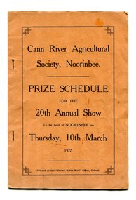
program, Snowy River Mail, 1927
Cann River is a town in the East Gippsland region of Victoria in Australia. The town is located on the Cann River at the junction of the Princess Highway and the Monaro Highway, in the Shire of East Gippsland. Before 1929 the original Cann River settlement was where Noorinbee now stands.Agricultural shows are an important part of cultural life in small country towns and these shows form an integral part of local history. This item reflects the significance of a volunteer group which no longer exists.A stapled paper program, orange with black print,"Cann River Agricultural Society, Noorinbee Prize Schedule for the 20th Annual Show to be held at Noorinbee on Thursday 10th March 1927" inside a rectangular black frame. -
Marysville & District Historical Society
Document (Item) - Document-Table, Judith Vimpani, Yarra Track Hostelries- Marysville to Woods Point, Unknown
A document outlining all the hostelries that existed along the Yarra Track between Marysville and Wood's Point.A document outling all the hostelries that existed along the Yarra Track between Marysville and Wood's Point.yarra track, marysville, wood's point, woods point, fernshaw, paradise plains, black spur, mount grant, george edwards, walker family, melbourne, new chum, hit & miss restaurant, mr clifford, michael woods, glen watts, tri bhean hotel, ewen cameron, ewen hugh cameron, thomas barton, butler's wood's point directory, globe hotel, swanston street, mount juliet, ben more & c, jordan district, jefferson's watts bridge inn, matthew jefferson, reefer's hotel, boyle's hotel, william henry johnson, samuel boyle, black spur hotel, fisher's creek, narbethong, fisher's home hotel, black spur inn, frederick fisher, william hodson, wood's point road, acheron river, acheron bridge hotel, john robson, granton, clifford, wilks creek, wilks creek hotel, patrick maloney, steavenson, marysville hotel, australian hotel, junction hotel, the dutchman's restaurant, henry kuyper, william podlech, mount arnold, mount arnold hotel, charles schultz, james toohey, john gleeson, joy burchall, ian newman, henry brockman, belle isle, belle elle, bellell creek, upper yarra, guerin's bridge, bell's hotel, henry petty, celia moran, ruth petty, cumberland creek, cumberland creek store and restaurant, cumberland creek hotel, charles edwin hargreaves, annie hargreaves, urina hargreaves, alice hargreaves, healesville, josiah hargreaves, henderson drysdale, henry whelan, halfway house, thomas smith, svendson, gosling, donovans creek, chesterville, perry's hotel, john perry, perry's coach and horses hotel, edward courtney, scandinavian hotel, the swede's, walker's hotel, jacob burchart, golden fleece, theodore kappler, george koehler's hotel, david walker, millicent walker, elsie jowett, bill walker, big river, royal mail hotel, shaw's, slingsby davies, edwin jones, elizabeth jane parker, sandridge, archibald charles edwin jones, matlock, alexander myers, frank berwick frederick jones, ned jones, jennie jones, sophie milllicent parker jones, thomas shaw, dorothy walker, travellers rest hotel, reefton, summers, john fehring, f fehring, katerina fehring, john christoph blumeyer, anne fehring, john baker, evelyn observer, anna katrina baker, hannah catherine baker, john frederick baker, mcmahon's creek, oaks, the springs, st clair, sinclair's valley, mountain home hotel, neilson, collins, waters, jan emma sinclair, john sinclair, mr cox, peter sinclair, willie we have missed you hotel, spring vale hotel, robert matthews, thomas crawford -
 Port Fairy Historical Society Museum and Archives
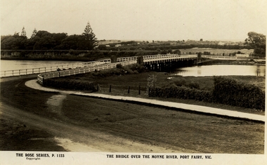
Postcard, The Rose Series / The Rose Stereographs, The Bridge over Moyne River, Port Fairy Vic
Black and white Photograph of the Moyne river road bridge with the botanical gardens in the left background and some huts built possibly on Hughes AvenueThe Rose Series P.1123 copyright.- The Bridge over the Moyne River Port Fairy Vic.moyne bridge, hughes avenue, gipps street, river, dunes, botanical gardens -
 Port Fairy Historical Society Museum and Archives
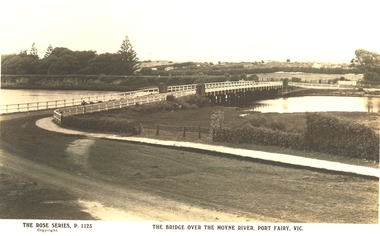
Postcard, The Rose Series / The Rose Stereographs, The Bridge over Moyne River, Port Fairy Vic
Black and white Photograph of the bridge over the Moyne river with the Botanical Gardens on the left in the background and also some huts on Hughes Avenue in the backgroundThe Rose Series P. 1123 copyright- The Bridge over the Moyne River Port Fairy Vic.moyne bridge circa 1930, moyne river, bridge, river, botanical gardens -
 Flagstaff Hill Maritime Museum and Village
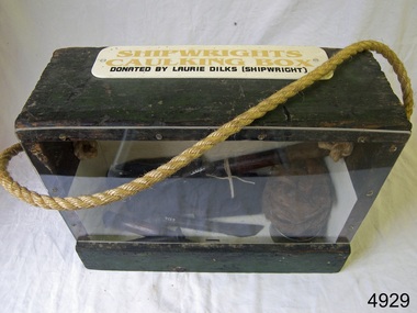
Equipment - Toolbox, Laurie Dilks, shipwright, Mid-to-late 20th century
Caulking is a process used by shipwrights and other tradespeople to seal the gaps and cracks in boats and ships, buildings and plumbing fittings. It prevents water, air and pests from entering the through the gaps. The shipwright’s caulking box and a display of shipwright's tools are connected to the maritime history of Victoria through their past owner, user and donor, Laurie Dilks. Laurie began his career as a shipwright in the mid-1900s, following in the wake of the skilled carpenters who have over many centuries used their craft to build and maintain marine vessels and their fittings. Laurie worked for Ports and Harbours, Melbourne, for over 50 years, beginning in the early 1960s. He and a fellow shipwright inscribed their names on a wheelhouse they built in 1965; the inscription was discovered many decades later during a repair of the plumbing. Many decades later Laurie worked on the Yarra River moving barges up and down the river and was fondly given the title ‘Riverboat Man’ His interest in maritime history led him to volunteer with the Maritime Trust of Australia’s project to restore and preserve the historic WWII 1942 Corvette, the minesweeper HMAS Castlemaine, which is a sister ship to the HMAS Warrnambool J202.The shipwright’s caulking box containing caulking tools is an example of the equipment used by shipwrights in the early to mid-20th centuries. This box is connected to the maritime history of Victoria through its past owner, user and donor, Laurie Dilks. Laurie began his career as a shipwright at Ports and Harbours in Melbourne in the mid-1900s, following in the wake of the skilled carpenters who have over many centuries used their craft to build and maintain marine vessels and their fittings.Shipwright's caulking box, green wooden exterior with green and cream interior. Box has a Perspex face. A rope handle, knotted on each end, extends from one side to the other. A white rectangular plaque with rounded corners is screwed to the top and has yellow and black printed text. The donor was shipwright Laurie Dilks.Printed on plaque "SHIPWRIGHTS / CAULKING BOX / DONATED BY LAURIE DILKS [SHIPWRIGHT]'"flagstaff hill, flagstaff hill maritime museum and village, warrnambool, maritime museum, maritime village, great ocean road, shipwreck coast, caulking tools, caulking equipment, caulking box, shipwright's tools, laurie kilks, ports and harbours -
 Kew Historical Society Inc
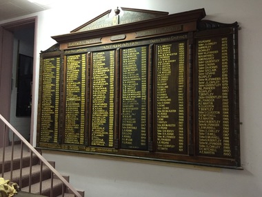
Memorabilia, MUIOOF: Port Phillip District/Yarra Yarra District Honour Board, 1930
The MUIOOF Lodge was located in Union Street, Kew. The Lodge was established in 1863. It was demolished in the early 1990s.The Lodge Board lists the names of representatives of many of Kew's pioneering families. The Board was donated to the Society when the Hall was demolished. MUIOOF Lodge Board - Yarra Yarra District, Loyal Kew Lodge No. 5093 Port Phillip District till 1888 / Yarra Yarra District from 1888 Past Grands [listed] W.Woolard 1864 to A.E. Martin 1990 Maker marks - [Painted on back panel] "Lodge Board - Written by Bro. J. Kleiner, Signwriter 432 Burwood Rd. Glenferrie March 1930".[Engraved on pediment] "G.E. Gosbell, Woodcarver 1955". muioof (kew), yarra yarra district, port phillip district, j. kleiner, manchester unity independent order of oddfellows, w. woollard, d. gray, g. taylor, d. dannock, e.g. backwell, s. conder, j.h. joyce, r. summers, r. clulow, w. morris, f. fanhauser, j. waters, w. butson, a. dalton, t.g. jellis, j. watson, w. howieson, a.h. alexander, w.h. perry, a.r. studd, t. greenhill, w.a. hunt, w. maslen, t. eakins, h. ellis, a. geoffrey, j. priestman, t.e. morrisjamieson, c.h. bryan, g. hinchcliffe, t. foley, a.j. conder, s. clapham, a. cornish, f.j. fauvel, e.m. bond, h. co, j.g m. moller, e. hillier, w. finucane, w.e. bristow, v. geoffrey, a. hill, j.t. studd, h. de c. kellett, a.j whittaker, e. foley, e.f. fordred, p.j. ridgeway, j. barnard, h.a. ingham, h. woollard, j.w. fuller, e. mclean, p.g. pearce, f. walsh, h. fryar, h. salisbury, h. woolard, h.c. cox, a.j. watson, w. holt, f.t. james, e.c. parry, g. lees, h.o. ada,s, g.c. barclay, g.h. mockridge, g. philpott, j. corser, a. lilburn, w.p. wheeler, t.e. morri, r.r. clarke, h.d. sisson, w.r. harle, w.g. gray, j.d. newman, c.w. laidler, e.a. rae, a.a. homes, a. mcconachie, h.f. woollard, p.g. gallop, h.c. nelson, l.n. graebe, e.w. firth, n. rae, r.j. kelly, j. donaldson, f.t. jmes, c. till, t.j. doyle, s.m.f wills, w.l. smith, h. mcallan, h.a. morgan, a. kinns, w.r. adams, c.h. jones, g.h. carter, m. prout, a.w. bishop, k.c. hemmings, e.k. sparls, l.m. harle, j.m. prout, l.e. watts, d.b. adams, f.u. woolard, a. macrae, n.l. gration, d.h. vickers, m.h.m. alister, t.a. till, r.w. bent, j.w. woolard, a.e. woolard, r.h. harle, jean harle, l.o. adams, d.h. lloyd, k.w. harle, d.g. mclean, p.s. pearse, v.l. profitt, f.c. marks, m.h. mcalister, j. newman, e.m. savory, a.f gration, c.g. teasdale, e.k. sparkes, a.j. scott, w.h. savory, t.r. holland, g.t. smith, d. adams, s. rowe, t. bentley, l.e. fegan, m.j. fiander, g.n. bentley, j.l. oakley, h. brierley, b. oakley, m. j. fiander, w. humphries, a. weingardt, c. nunn, d.a. adams, s.p. clark, s. evans, g.n.bentley, s. clugston, d.c. mitchell, a.e. martin, g.n bentley, l.b. murrell, t.b. will, d. murrell -
 Wodonga & District Historical Society Inc
Album - Ringer's River by Des Martin - Plate 14 - O'Day visits the O'Hara's homestead
Daylight O'Day swims the river alone and, instead of going straight back to Gooloora, rides up-river a little to call at O'Hara's slab homestead where he is given a very warm welcome by young Erin O'Hara. Ellen Tenteye as Erin O'Hara.The album and images are significant because they document literature written by a prominent member of the Wodonga community. The presentation of this precis was supported by several significant district families and individuals.Ringer's River Album Coloured photo Plate 14des martin, many a mile, ringer's river, northeast victoria stories -
 The Beechworth Burke Museum
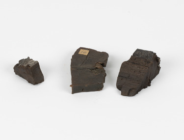
Geological specimen - Coorongite
Coorongite is a dark, rubber-like, highly resilient structureless algal deposit. In the Coorong district of South Australia it occurs in moderate quantities associated with the coastal swamps and sand dunes which extend for a considerable distance east of the mouth of the Murray. This particular specimen was recovered from the south of the Coorong River, South Australia. A type of sediment rich in organic matter, Coorongite is the unlithified end-member of the sapropelic coal series. The members of the sapropelic coal series can be ranked in order as sapropel (the unlithified form), sapropelic-lignite, and sapropelic-coal (the lithified forms) based on increasing carbon content and decreasing volatile content. Sapropel (Coorongite) is an unlithified dark, pulpy, fine organic mud containing concentrations of algae and miospores that are more or less identifiable. Coorongite is typically found as an algae like substance, that can be found in irregular size pieces. Coorongite was believed to be dried up oil due to its rubber-like texture. The Coorongite is also soft to the point where it can be cut into with a knife or it can be broken and torn by hand. Otherwise known as 'Kurangk', the Coorong River is home to the Ngarrindjeri people, which acts as both a place for gathering food and a spiritual place. In 1852 the first sight of Coorongite was found along the Coorong River. The finders mistook the Coorongite for dried up oil, which lead to the belief that there were oil reserves under the Coorong River. Between the 1860s and the 1930s the Coorong River became a place where mining oil and Coorongite became precedent. Nowadays, the local council and the South Australian Government are working together with the Ngarrindjeri people to sustain and preserve the Coorong River and the culture that is with it. Soon after gold was discovered in 1851, Victoria’s Governor La Trobe wrote to the Colonial Office in London, urging ‘the propriety of selecting and appointing as Mineral Surveyor for this Colony a gentleman possessed of the requisite qualifications and acquaintance with geological science and phenomena’. Alfred Selwyn was appointed geological surveyor in Australia in 1852 which began the Geological Survey of Victoria. Selwyn went on to collect geological samples and catalogue thousands of specimens around Australia. In 1853-69 the Geological Survey issued under Selwyn's direction sixty-one geological maps and numerous reports; they were of such high standard that a writer in the Quarterly Journal of the Geological Society of London bracketed the survey with that of the United States of America as the best in the world. During his years spent in Australia, Selwyn collected numerous significant geological specimens, examples of which are held in collections such as the Burke Museum.Coorongite is considered to be a mineral with a unique texture, where it can be both hard and soft. Coorongite can also be considered to be a rare mineral, as it is only located along the Coorong River and due to the mining of it, has left very few sources. It was believed at one point that Coorongite could be used to replace oil. This specimen is part of a larger collection of geological and mineral specimens collected from around Australia (and some parts of the world) and donated to the Burke Museum between 1868-1880. A large percentage of these specimens were collected in Victoria as part of the Geological Survey of Victoria that begun in 1852 (in response to the Gold Rush) to study and map the geology of Victoria. Collecting geological specimens was an important part of mapping and understanding the scientific makeup of the earth. Many of these specimens were sent to research and collecting organisations across Australia, including the Burke Museum, to educate and encourage further study.Three solid varyingly hand-sized pieces of wooden appearing organic matter derived from the river in the Coorong District in South Australia. A rubber-like, highly resilient structureless algal deposit.Specimen 245 page 69 / in Descriptive Register / "Elcestic Bitumen, / Coorangite" South of / Coorung River, South Australia . / C. WIllman / 15/4/21burke museum, beechwoth, indigo shire, beechworth museum, geological, geological specimen, mineraology, coorong, coorong river, kurangk, ngarrindjeri, south australia, coorongite, coorongite specimen -
 Orbost & District Historical Society
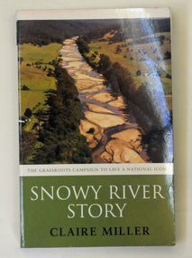
book, Snowy River Story, April 2005
This book recounts the story of the campaign by Dalgety and Orbost to restore water to the Snowy River. Claire Miller is a senior journalist for The Age newspaper with a special interest in the environment. She has covered this campaign since 1999.This book recounts the story of the campaign by Dalgety and Orbost to restore water to the Snowy River. It is significant to this collection as many of the current residents of Orbost were involved in the campaign.A 270pp paperback book titled Snowy River Story written by Claire Miller. On the front cover is a coloured photograph of the Snowy River at Bete Bolong. It documents the story of the campaign to save the Snowy River.snowy-river snowy-mountains-hydro-electric-scheme environmental -
 Melbourne Legacy
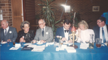
Photograph, Induction of Yarra Valley President 1989, 1989
Photos of a dinner to welcome the new president of the Yarra Valley Legacy Club's new president in 1989. Melbourne Legacy President Chas Wilks attended the induction (in the grey suit). Other names are not known.Representatives from Melbourne Legacy attended the important events of other Legacy clubs.Colour photo x 4 of the induction of the Yarra Valley's new president in 1989.legatee event, yarra valley branch -
 Wodonga & District Historical Society Inc
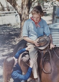
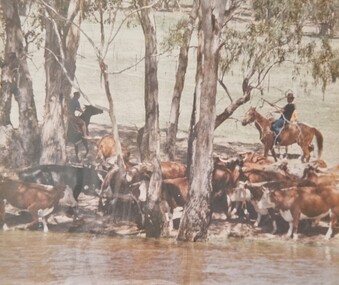
Album - Ringer's River by Des Martin - Plate 21 - Swimming cattle across to Victoria
But O'Day, the general, has chosen this particular time to ride up river and meet a mob of cattle that Charlie Clowes is bringing down for him from Camoola. In the first of many such successful operations the cattle are swum across to Victoria at the point where O'Day's run, Brightons, comes down to the river.The album and images are significant because they document literature written by a prominent member of the Wodonga community. The presentation of this precis was supported by several significant district families and individuals.Ringer's River Album Coloured photo Plate 21des martin, many a mile, ringer's river, northeast victoria stories -
 Kew Historical Society Inc
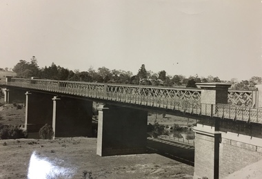
Photograph, Outer Circle Railway Viaduct, 1919
Railway Viaduct constructed for the Outer Circle Railway. Bridge designed by John Monash, engineer. Converted into a state highway, 1930s.Dateable photo of an important piece of Victorian railway infrastructure.Photograph of Outer Circle Railway Bridge over River Yarra, Fairfield. Looking toward Lugton Street, showing fence underneath taken from the Chandler Highway. Reverse: "Outer Circle Railway Bridge over River Yarra Fairfield, H0276, Property of Miss Foley"railway viaduct, chandler highway