Showing 10975 items matching " plan."
-
 Warrnambool and District Historical Society Inc.
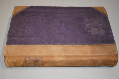
Letter book 13, 1920
This letter book contains letters, sketch maps and plans and dates from 1920 to 1923. It came from the office of John William Crawley Junior, an engineer, architect and surveyor in private practice in Warrnambool and also the engineer for the Shire of Warrnambool from 1895 to 1935. His father, brother and son were also engineers and worked in that capacity or as the Shire Secretary for the Shire of Warrnambool, with the Crawley family recording a total of 132 years of service to the Shire. The letter book was passed onto John Crawley’s son, Rolf, the engineer for the Shire of Warrnambool from 1935 to 1968. It then came into the possession of Michael Hand who took over the private surveying business on Rolf Crawley in Warrnambool. The Warrnambool and District Historical Society acquired the letter book, along with several other Crawley ledgers, from the estate of Michael Hand. This letter book is of considerable significance as it contains letters and maps drawn up by John William Crawley, an engineer in the Shire of Warrnambool for 40 years. It will be very useful for researchers.This is a dark red hard- cover letter book of 1001 pages. The book has brown binding on the corners of the cover and on the spine. There is gold lettering on the spine. The inside of the cover is lined with a multi-coloured mottled pattern. The cover is stained and scuffed. The pages contain handwritten letters, sketch maps and plans and an alphabetical index at the front. There are three loose pages. There is a mauve stamp on the first page.‘Letter Book 1920 to 1923’ ‘Rolf. L. Crawley Civil Engineer, Drainage and Water Supply Engineer, Licensed Surveyor, Registered Architect, Warrnambool’ john william crawley junior, warrnambool, rolf crawley, warrnambool, shire of warrnambool -
 Federation University Historical Collection
Plans, Plans of the Ballarat School of Mines, Lydiard Street South, Ballarat, 1953
.3) Ballarat School of Mines plan for water supply installation to prefabricated classrooms associated with the Ballarat Girls' Techncial School, April 1953 .4) Ballarat School of Mines plans for three prefabricated classrooms to be used as the Ballarat Girls' Techncial School, Hickman Street, Ballarat by Percy E. Everett, 16 December 1952. Earthworks undertaken by T.G. James. .5) Ballarat Sewerage Authority Plan of Drainage Prefabricated Class Rooms Ballarat School of Mines by Chief Architect Percy E. Everett, 13 April 1953. The plan shows basket ball court and shelter, classrooms, contours, excavations and girls toilet associated with the Ballarat Girls' Techncial School, Hickman Street, Ballarat. ballarat junior girls' technical school, ballarat girls' technical school, ballarat school of mines, hickman street, white flat, t.g. james -
 Bendigo Historical Society Inc.
Document - MERLE HALL COLLECTION: ROSALIND PARK CREATIVE VILLAGE BENDIGO PLAN OF MOSAIC AND TYPICAL REEF CONTOURS, 1990s
MERLE HALL COLLECTION: ROSALIND PARK CREATIVE VILLAGE BENDIGO Plan of Mosaic and Typical Reef Contours 3858.14.pdf contains five pages First Page: Describes the plan the mosaic is a stylised representation of the cenral area of the main Bendigo Goldfield. A typical croos section ogf the Bendigo Goldfield. The mosaic are based on actual mine layouts. The artist has used gold as her inspiration. Second Page: A plan of the mosaic using the atomic structure of gold. Third Page: A plan of the quartz vains winding through the earth, containing gold in its various forms. Fourth Page: A typical reef layout in the Bendigo Goldfields and cross sections. Fifth page: On of the Mosiaic depicking a bird -
University of Melbourne, Burnley Campus Archives
Plan, Royal Botanic Gardens Melbourne, 1978
Plan of RBG with grid references. Produced by Dept. of Crown Lands and Survey, Victoria, Division of Survey and Mapping. Prepared in 1978 from surveys completed in 1976. (1) 2 copies plan. Main areas, buildings, etc., labelled, beds outlined. (2) Original coloured plan and reduced size photocopy. More labelling, particularly beds (handwritten). Labelled Jeremy J. Wallace with handwritten notes on reverse re a project. (3) Reduced size photocopy. Handwritten labelling of beds. (4 - 11) Enlarged photocopies of sections of (1) Handwritten notes and plant labelling. (1). Photgraphed copies by FRESCO 510131-TA. (12) Plan on a grid, coloured. "No Public Access," areas marked.jeremy j. wallace, royal botanical gardens melbourne, department of crown land and survey division of survey and mapping, ornamental lakes -
 Kew Historical Society Inc
Plan - Subdivision Plan, Forres Estate, East Kew, 1919, 1919
Pru Sanderson, in her groundbreaking ‘City of Kew Urban Conservation Study : Volume 2 - Development History’ (1988), summarised the periods of urban development and subdivisions of land in Kew. The periods that she identified included 1845-1880, 1880-1893, 1893-1921, 1921-1933, 1933-1943, and Post-War Development. These periods were selected as they represented periods of rapid growth or decline in urban development. An obvious starting point for Sanderson’s groupings involved population growth and the associated economic cycles. These cycles also highlighted urban expansion onto land that was predominantly rural, although in other cases it represented the decline and breakup of large estates. A number of the plans in the Kew Historical Society’s collection can also be found in other collections, such as those of the State Library of Victoria and the Boroondara Library Service. A number are however unique to the collection.Subdivision plans are historically important documents used as evidence of the growth of suburbs in Australia. They frequently provide information about when the land was sold on which a built structure was subsequently constructed as well as evidence relating to surveyors and real estate and financial agents. The numerous subdivision plans in the Kew Historical Society's collection represent working documents, ranging from the initial sketches made in planning a subdivision to printed plans on which auctioneers or agents listed the prices for which individual lots were sold. In a number of cases, the reverse of a subdivision plan in the collection includes a photograph of a house that was also for sale by the agent. These photographs provide significant heritage information relating house design and decoration, fencing and household gardens.An annotated subdivision plan for the Forres Estate, Kew East. The estate was advertised in 1919, the Melbourne Auctioneers being represented locally by Henry Kellett, Estate Agent of High Street, Kew. The name of the estate was derived from the mansion (demolished 2016) of the same name in Normanby Road, which was at one stage owned by the Mayor of Kew, Cr. J. S. Were.subdivision plans - kew, forres estate, argyle road, simpson street, hubert street, normanby road -
Federation University Historical Collection
Document, Ballarat Junior Technical School Building
The Ballarat Junior Technical School, a division of the Ballarat School of Mines, was established in 1913 and moved into a new, custom built building in 1921.Four photographs of the newly completed Ballarat Junior Technical School. .1) Drawing of a plan for a building on the Ballarat Gaol site in 1947 .2) Newspaper photographs of entrance to the Ballarat Junior Technical School .3 & .4) Plans for the Ballarat Junior Technical School on the Gaol Reserve drawn by George Crawley in 1934. ballarat junior technical school -
 Orbost & District Historical Society
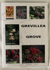
Book, Grevillea Grove, 2017
This book was compiled and published in 2017. The contents are based on a scrapbook and photographs compiled by Margaret Kleinitz who was Secretary of the Orbost Garden Club during the time when Grevillea Grove was proposed and developed from1979-1989. The development of this garden in a disused quarry in Orbost involved a substantial community campaign and on-going effort, particularly from members of the Garden Club. The demise of Grevillea Grove came when the Vic. Govt. decided to develop this parcel of crown land for a Rainforest Garden and Information Centre. Local resident, Audrey Van Den Berg has compiled this book. Shows the effort and dedication involved in this community project.A 40 page book with cardboard cover. Front cover has 6 colour photos of Grevillea plants overlaid onto a plan of the Grevillea Grove garden. This book contains b/w photographs and a written history of the creation of the Grevillea Grove garden in Orbost. It also has site plans and newspaper articles.GREVILLEA GROVE grevillea grove, orbost -
Port Melbourne Historical & Preservation Society
Plan - MMBW, Melbourne and Metropolitan Board of Works (MMBW), 1894 - 1895
Located on State Library Victoria (SLV) website by member Ray JelleyMelbourne Metropolitan Board of Works (MMBW) waste water (sewer) plans from 1894-95. Plan numbers 322, 331, 335, 564, 565, 575. Area bounded by Liardet St, East Esplanade, Foote St, Johns(t)on St and Hobsons Bay. Includes Gas works and Distillery.engineering - board of works, sewerage, mmbw, melbourne and metropolitan board of works -
 University of Melbourne, Burnley Campus Archives
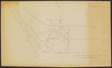
Plan - Sketch, School of Horticulture - Burnley, 1957
A,B,C,E paper copies, D, tracing paper copy of plan. Hand drawn sketch of central area of grounds. Figures given for acreage of ornamentals, crops and grazing although only 1 acreage is shown on plan. (E) has further annotation. Scale 1 inch:40 ft.burnley gardens, ornmental, crops, grazing, burnley school of horticulture -
 Bendigo Historical Society Inc.
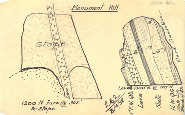
Document - MCCOLL, RANKIN AND STANISTREET COLLECTION: MONUMENT HILL PLAN
Plan of Monument Hill mine drawn in black ink on buff coloured tracing paper. Plan shows diagram of stope and describes rock profile; 1" F.W. quartz, lava, slate H.W. quartz and slate with threads of quartz. Hard sandstone on side of stope. Signed LCS (?) 8/4/38business, mining, monument hill consolidated company -
 Bendigo Historical Society Inc.
Map - UNITED HUSTLER'S & REDAN & K. K. MINES - PLAN OF UNITED HUSTLER'S & REDAN & K. K. MINES
Plan of the United Hustler's & Redan & K. K. Mines on the Hustler's Line of Reefs Bulletin No 33 Plate No XXVIII. Plan shows depth of levels, stone encountered and some geological features. Geological Survey of Victoria emblem and signed by H S Whitelaw, Underground Survey Office Bendigo, September 1913. mining, parish map, united hustler's & redan & k. k. mines, united hustler's and redan shaft, k. k. shaft, h s whitelaw -
 Flagstaff Hill Maritime Museum and Village
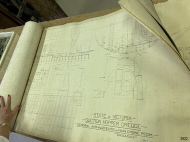
Plan - Vessel, Public Works Department (P.W.D.), Matthew Flinders I, 8-11-1911
These plans are line drawings by the State of Victoria for a Suction Hopper Dredge, which used a suction pump to bring up material from the bottom of a body of water. The plans are contained in a box from the Public Works Department, Ports and Harbours Division in Melbourne, which in the year 1910 was responsible for the dredging operations of coastal ports and harbours, and inland waterways. The stamped signature is that of Arthur Edward Cutler, Chief Engineer, Public Works Department of New South Wales. The steel steamer Matthew Flinders was constructed by Morts Dock & Engineering Co Ltd in Sydney, New South Wales. Identified as Ship No. 40 by the ship builders, this dredge, had twin screw engines that were made in Sydney. Its gross tonnage was 1180. It was launched on July 15th, 1916, and registered by the owner, Department of Public Works in Victoria, at the Port of Melbourne in 1917. Unlike bucket dredges, the Matthew Flinders did not use permanent moorings but instead had bow and stern anchors. It travelled forward on the bow anchor, taking up a strip of even-depth wilt from the bed below. A local newspaper noted that the Matthew Flinders has many advantages that were especially useful for its work at Warrnambool. Warrnambool Harbour had been experiencing silting and sanding for many years. The problem continued even after the construction of the Breakwater in 1890, which was overseen by New Zealand engineer Arthur Dudley Dobson. Melbourne’s Department of Ports and Harbours sent the new Matthew Flinders to dredge the heavy silting in the Warrnambool Harbour in May 1919. This work was previously done by the smaller dredge, the Pioneer. However, after a month of work, the Matthew Flinders was returned to Melbourne for alterations to make it suitable for work in the heavy seas it experienced at Warrnambool. Both dredges were sent up from Melbourne when required over the years to periodically attend to the silting in the Harbour, but the Matthew Flinders was preferred because of its efficiency. It was still dredging the Harbour even in July 1938. The ship’s original master was J G Rosney. In 1923 the master in charge was Captain Dunbar. In 1930 the dredges were no longer required as the Harbour was no longer suitable as port.These plans are significant for their close association with the suction hopper dredge, the Matthew Flinders I, which was call upon often to remove the silting of Warrnambool Harbour and allow shipping to continue in the Port of Warrnambool until 1930, when the Port of Warrnambool ceased to be suitable as a port. The work done by the Matthew Flinders is significant for its association with the Warrnambool Breakwater and the on-going issues with the silting of the Harbour. Plans with line drawings for the suction hopper dredge Matthew Flinders, rolled, in open-top wooden box. Created for the Public Works Department, Melbourne, Victoria. Stamped with signature and dated November I, 1911. Inscriptions: label on box, handwriting on box, drawings and outer layer of paper. Freighted by 1 Star, New Zealand Express Cargo.Signature stamp “A E Cutler” Date stamp “NOV 8 – 1911” Printed on one page “STATE OF VICTORIA / SUCTION HOPPER DREDGE / GENERAL ARRANGEMENTS OF MAIN ENGINE ROOM / SCALE 1/2 IN = 1 FT.” Label on box "1 [star symbol] / THE NEW ZEALA- - - / EXPRESS CAR - –“ Handwritten on base “PUBLIC WORKS / DEPARTMENT / - - LBOURNE” Handwritten in pencil on cover paper “MATTHEW Flinders”flagstaff hill, warrnambool, maritime village, maritime museum, flagstaff hill maritime museum & village, shipwreck coast, great ocean road, plan, line drawing, dredge, pioneer, steel steam ship, twin screw engines, a e cutler, arthur edward cutler, chief engineer, public works department, new south wales, nsw, 1911, state of victoria, suction hopper, main engine room, public works melbourne, warrnambool harbour, lady bay, sanding, silting, breakwater, morts dock & engineering co ltd, j g rosney, captain dunbar, ship no. 40, matthew flinders i, matthew flinders, 1 star, new zealand express cargo -
 Bendigo Historical Society Inc.
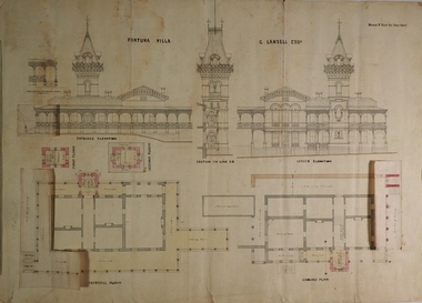
Plan - FORTUNA COLLECTION: FORTUNA VILLA
Originally built by Christopher Ballestedt (1796-1869) and his son Theodore. The Ballestedt's pioneered open cut and quartz mining on the Bendigo gold field. They were very successful. After Christopher's death, Theodore continued until 1871 when he sold Fortuna, their mines and equipment to George Lansell for 30,000 pounds.Four large plans of Fortuna villa. Scale 1:50 Australian survey office - Victoria Department of Administrative services. Fortuna Bendigo - Army Survey Regiment. Dept. of Defence - Army. Terrestrial Photogrammetric Survey. Project number: 8001/2. Reg. File: 64/531. Survey File:631. Draftsman: M.A. Osciak. Surveyed by G. Tucker. Date of Survey: 14/05/79. There are 4 large such plans in a plastic bag the measurement of the plans is approx. 115cm X 80 cm.plan, bendigo, fortuna villa -
4th/19th Prince of Wales's Light Horse Regiment Unit History Room
Map Set, Timor Leste, 1999
Operational maps for Australian Defence Force participation in InterfetSet of maps for Timor-Leste Op Interfet 1. Ermera District Navigation Map 1:25,000 2. Dare Area Special 1:25,000 3. Timor-Leste Parliamentary Elections 4. Dili Planning Map Overlay Timor-Leste 1:6,000 5. Timor-Leste Planning Mao -
 Bacchus Marsh & District Historical Society
Map, Balliang Parish Map, County of Grant c.1907
A single page paper map showing parish plan map for Balliang. This parish area contains the localities of Balliang and Balliang East and is located south of the township of Bacchus Marsh. The map is pasted into a bound volume containing 76 maps or plans in total. High resolution digital image stored on BMDHS computer network. balliang victoria maps, balliang parish maps -
 Bendigo Historical Society Inc.
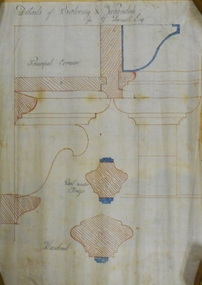
Document - MARKS COLLECTION: FORTUNA BALCONY AND VERANDAH PLAN FOR GEORGE LANSELL
Plan drawn in red and blue ink, on wax paper. Line drawing, on top 'Details of Balcony & Verandah for G. Lansell Esq' written in black cursive script. Other detail written and labelled Principal Cornice, Rail Under Frieze, Handrail. On bottom of plan purple stamp 'Vahland & Getzschmann, Architect, Sandhurst'.bendigo, house, fortuna villa -
 Bendigo Historical Society Inc.
Plan - MARKS COLLECTION: PLAN FOR THE ADDITION OF A FOUR LEVEL STAIRCASE TOWER TO THE GARDEN ELEVATION OF FORTUNA VILLA FOR GEO. LANSELL ESQ
Fortuna Villa was owned from 1855 to 1871 by Christopher and Theodore Ballerstedt, Australia’s first mining magnates. In 1871 it was purchased by George Lansell (The Quartz King) being one of Australia’s most successful and adventurous nineteenth century gold mine owners and speculators. Lansell made numerous alterations extensions to the building and remained in the Lansell family until 1935Plan for the addition of a four level staircase to the Garden Elevation of Fortuna Villa for George Lansell Esq. Plan shows: * Four levels of the staircase cobstructiob - Ground, Principal, First & Second levels of the staircase tower, with viewing walk at the second level * Entrance & garden elevations section showing exterior of the four level additionfortuna villa, george lansell, c & t ballerstedt, building plans -
 Ringwood and District Historical Society
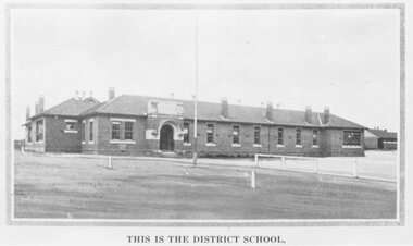
Photograph, Ringwood State School photograph for land sale - Charm-View Estate, Heathmont - 1926
Printed below picture, "This is the district school". Written on back of photograph, "Photo taken from Sub. Div. Plan Land Sale Charm-View Estate, Heathmont. 1926?" -
 Ringwood and District Historical Society
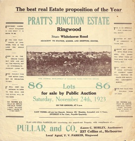
Flyer, Brochure for Land Sale By Public Auction, Pratt's Junction Estate, Ringwood, Victoria - 1923
Folded double-sided brochure advertising 86 residential lots for sale by Public Auction at 3pm, Saturday, November 24th, 1923, with town photographs, map of subdivision and summary of local features and services. Subdivision plan includes Whitehorse Road, Oliver Street, Georges Road, Junction Street, and six room weatherboard villa for sale. Local Agent - F.V. Parker, Ringwood. -
 St Kilda Historical Society
Ephemera - Invitation, Illustrated Public Lecture, 1954
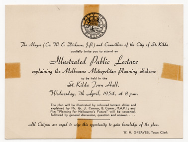
Invitation to a lecture on the Melbourne Metropolitan Planning Scheme, presented by the City of St Kilda, at the St Kilda Town Hall at 8pm on 7 April 1954. The lecture was to be illustrated by 'coloured lantern slides' and followed by a screening of the film 'Planning for Melbourne's Future'. The Melbourne Metropolitan Planning Scheme 1954: Report, compiled by the then Melbourne and Metropolitan Board of Work, began the planning system for Melbourne. It planned for a population of 2.5 million in the 1990s, a population actually reached in the 1970s. .White card printed in black on one sidemelbourne metropolitan planning scheme, town planning, planning -
Ringwood and District Historical Society
Land titles and plan, Victorian Titles Office, Titles and plans of Ringwood Land between Mullum Land and Wonga Rd. (Re Ann Jane Kennedy). 1907, 1-Oct-07
The documents pertaining to Ann Jane Kennedy inheriting the land from her late husband Samuel John Kennedy and the history of the transfers of land from Ann Jane Kennedy in 1907 until the title was cancelled in 1925 to James Melbourne Ross. The area was 10 acres between Mullum Mullum Road and Wonga Road retrieved from Titles Office.Ten pages of photocopied titles and plans of land in Ringwood between Mullum Road and Wonga Road, also transfer of original land. -
Federation University Historical Collection
Document - E.J. Barker Papers, Papers collected by E.J. Barker Related to School of Mines Ballarat and Ballarat Institute of Advanced Education Merger
E.J. Barker is a past principal of the School of Mines Ballarat and the Library at the Mt Helen Campus is named after him. School of Mines is a predecessor of Federation UniversityCorrespondence, Reports, Plans, Newspaper articles, Newsletters, notes and other papers from various institutions and Government departments relating to the merger school of mines ballarat, e.j. barker, merger report, approach to a merger, merger, d. woolley, scv/vic joint committee, scv, vic, ballarat institute of advanced education, state college of victoria, education advisory committee, minster for education, councils of colleges, academic committee, the age, uni must employ surplus staff, university boycott campaign, committees of council, enrolments, master plan soon for new state college, new principal for state college, bendigo advertiser, early decision expected on amalgamation, b.i.t and state college will be merged, f.j. rogers, j.a. chisholm, state college will build, tertiary planning in state of chaos, phone message, victoria institute of colleges, t. swanson, j. ryan, r. mcmullen, r. hinkley, commission on advanced education, newsletter, bendigo institute of technology, dr. law, r.w. birrell, colleges head for merger, mr mcdonnell, tender recommended, k.g. scarrott, r.w wirrell, r.e parry, enrolment forecasts, monash reporter, mt helen campus plan, notes, submission to the minister, report, choice of umbrella body, education merger sound, city of ballarat, i.c smith, australian universities commission, education department, ballarat institute of advanced education staff association, k.l jennings, multi-campus institutions, corporate nature of councils, future development, comments on merger, umbrella organisations -
Federation University Historical Collection
Ethnographic Material, Aboriginal Scrapers
The scraper is a stone tool made from a flake with one or more working edges. Geberally fro chiselling, cutting, gouging, or planing .aboriginal, stone, tool, scraper -
![Document collection, Watsonia development [Lambourn and Devonshire Roads], 2019_](/media/collectors/4f729f5697f83e03086015b8/items/5d82cea121ea6712b80a7cdd/item-media/5d8579dd21ea67168c696120/item-fit-380x285.jpg) Greensborough Historical Society
Greensborough Historical SocietyDocument collection, Watsonia development [Lambourn and Devonshire Roads], 2019_
In 2003, a proposal for a 5 storey building on the corner of Lambourn and Devonshire Roads Watsonia for an apartment complex, medical centre, shops and cafe was approved by VCAT, despite strong opposition by local residents. The proposal did not proceed. In 2019 a proposal for a 2 storey medical centre, cafe and residence was approved for the site and construction commenced. Collection of documents comprising history of development proposals by Rosie Bray, concept illustrations, archtect's plans, photograph and copy of newspaper clipping.watsonia, lambourn road watsonia, devonshire road watsonia -
Glenelg Shire Council Cultural Collection
Administrative record - Plans, n.d
Black and white photocopy of old plan of subdivision, same as 8398, 8399, smaller scale, numerous notations, added by Vanda Savill. -
4th/19th Prince of Wales's Light Horse Regiment Unit History Room
Lesson Plans, Browning MG Cal .50 in M2 HB, Jan 1979
A photocopy of the lesson plans used to teach the necessary facts about the gun so that the trainee gunner may appreciate its capabilitiesbrowning 50 cal machine gun -
Ringwood and District Historical Society
Envelope, Packet: Ringwood Regional Shopping Centre later Eastland. Town Planning from 1945, Clippings, Eastland Development Dispute
Town Planning and Development 1945; Newspaper cuttings Eastland Shopping Centre; Eastland development dispute; Regional Shopping Centre for Ringwood -
 Federation University Historical Collection
Book, The Old Pioneers' Memorial History of Melbourne From the Discovery of Port Phillip to the World War, 1924
Blue hard covered book of 494 pages. Images, and a large plan of prominent burials in the Melbourne Old Cemetery, and a Map of Melbourne. melbourne, melbourne cemetery, melbourne old cemetery, john batman, edmund hobson, batman's map, st francis' church, james balfour, mrs hornbrook, paddy's market, wilson hall, working men's college, henry kendall, le souef's cottage, world war one, westernport, melbourne cup, hoddle, collingwood, south melbourne, prahran, richmond, kew, brunswick, coburg, preston, hawthorn, camberwell, nunawading, doncaster, st kilda, brighton, sandringham, cheltenham, caulfield, oalkleigh, footscray, sunshine, north melbourne, carlton, ballarat school of art library, ballarat technical art school, book plate, library plate, hume and hovell's overland journey 1824-5, major mtichell's overland journey, australia felix, booplate, aborigine, aboriginal, captain cook, arthur phillip, isaac smith, george bass, matthew flinders, john murray, catain baudain, captain collins, edward henty, portalnd, map od melbourne in 1938, john pascoe fawkner, the "enterprise: and fawkner's first home, old colonists' homes, rushall crescent north fitszroy, richard bourke, the old melbourne post offfice, old governmnt house, toorak, latrobe's house at jolimont, first melbourne land sale, melbourne water supply, peter henry smith, victorian legislative council opening, map of melbourne and collingwood, prince's bridge, crossing the rivers by punt, f.a> rucker, canvas city emerald hill, arrival of the gold escort in melbourne, the yarra, queen's wharf, tall ships, old st james, mary e. budd, st francis church, michael carr, meolbourne city mission, state library of victoria, melbourne public library, bourke street, angus mcmilan, methodist ladies college, ormond college, armistance celebrations, robert russell, mia mia, theatre royal bouke st, melbourne from flaggstaff hill, federal coffee palace collins st, lord melbourne, melbourne mint, old melbourne town hall, robert russell's melbourne and yarra falls, mandevalle hall, point lansdale lighthouse, wilson's promontory, margaret m. ward cole, williamstown, flinders st melbourne, queenscliff battery, broadmeadows soldiers' camp, embarkation of first troops on the 'ceramic', general monsash, ian hamilton, general bridges, victorian war memorial, national war memorial, st kilda pier, first melbourne cup, hoddle's grid, albert park, melbourne mechanic's institute, st kilda toll gate, munted policeman, springthorpe memorial, james bonwick, mornane's paddock, victorian railways melbourne and surburban lines, carlton gardens, thomas napier, wiliam westgarth, george augustus robinson, william lonsdale, elizabeth mary batman, peomena frances darling batman, dig tree, exhibition of 1854, exhibition of 1866, exhibition buildings, geelong harbour, jubilee lake, port campbell, warrnambool, queenscliff lightboat, batman's first house -
 Bendigo Historical Society Inc.
Book - THE KINGDOM OF GOD
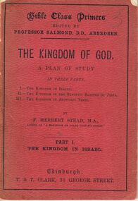
Book, Les Gillies Collection, A small red soft covered book titled '' The Kingdom Of God''. A plan of Study in 3 parts. -
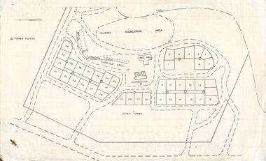 Bendigo Historical Society Inc.
Document - STATE RIVERS AND WATER SUPPLY COMMISSION : EPPALOCK RECREATIONAL AREA PLAN?
Photocopied plan of power points for a recreational area, possibly Eppalock foreshore recreational area?. No title, and undated. With other Eppalock documents.state infrastructure, water supply, coliban system, state rivers and water supply commission. coliban system. eppalock.