Showing 10434 items
matching sites
-
 Churchill Island Heritage Farm
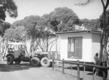
Photograph - Photograph of demountable on back of truck
Churchill Island Heritage Farm has a large photograph collection dating from the nineteenth century. This series provides an insight into the early days of Churchill Island as a Conservation site.Black and White photograph of the old Churchill Island ticket booth that used to be located on the bridge. Catalogue number written on reverse in pencil. Handwritten on reverse 'The ticket office at Bridge on loan from Golden Homes Wonthaggi Courtesy Mr Henry Donahue'churchill island -
 Churchill Island Heritage Farm
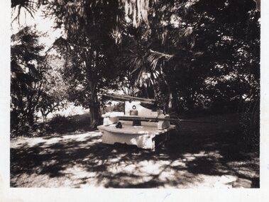
Photograph - Photograph of the Churchill Island cannon
Churchill Island Heritage Farm has a large photograph collection dating from the nineteenth century. This series provides an insight into the early days of Churchill Island as a Conservation site.Black and White photograph of the old Churchill Island cannonCatalogue number written on reverse in pencil. Handwritten on reverse 'A16 6'churchill island -
 Churchill Island Heritage Farm
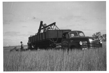
Photograph - Photograph of truck in paddock
Churchill Island Heritage Farm has a large photograph collection dating from the nineteenth century. This series provides an insight into the early days of Churchill Island as a Conservation site.Black and White photograph of a truck loaded with machinery in the paddock. To the left, two men are working with equipment.Catalogue number written on reverse in pencil. churchill island -
 Churchill Island Heritage Farm
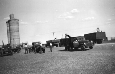
Photograph - Photograph of line of trucks and silo
Churchill Island Heritage Farm has a large photograph collection dating from the nineteenth century. This series provides an insight into the early days of Churchill Island as a Conservation site.Black and White photograph of a line of trucks, trailers, and tractors with a concrete grain silo in the background.Catalogue number written on reverse in pencil. Handwritten on reverse "NOT Churchill Island'churchill island -
 Churchill Island Heritage Farm
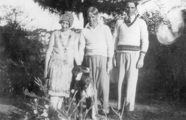
Photograph - Photograph of group of people
Churchill Island Heritage Farm has a large photograph collection dating from the nineteenth century. This series provides an insight into the early days of Churchill Island as a Conservation site.Black and White photograph of two men and a woman with two dogs in the foreground. They are standing in front of a pine tree and bushes.Catalogue number written on reverse in pencil.churchill island -
 Churchill Island Heritage Farm
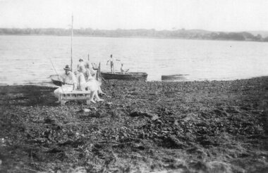
Photograph - Photograph of people sitting on a jetty
Churchill Island Heritage Farm has a large photograph collection dating from the nineteenth century. This series provides an insight into the early days of Churchill Island as a Conservation site.Black and White photograph of a group of people sitting on a jetty with two men standing in a dinghy in the backgroundCatalogue number written on reverse in pencil.churchill island -
 Churchill Island Heritage Farm
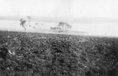
Photograph - Photograph of ploughed field leading to shoreline
Churchill Island Heritage Farm has a large photograph collection dating from the nineteenth century. This series provides an insight into the early days of Churchill Island as a Conservation site.Black and White photograph of a ploughed field leading to shorelineCatalogue number written on reverse in pencil.churchill island -
 Churchill Island Heritage Farm
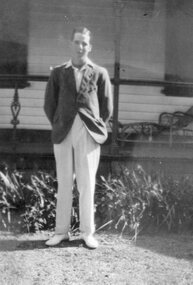
Photograph - Photograph of man
Churchill Island Heritage Farm has a large photograph collection dating from the nineteenth century. This series provides an insight into the early days of Churchill Island as a Conservation site.Black and White full body portrait of a man standing in front of Amess HouseCatalogue number written on reverse in pencil.churchill island, photograph -
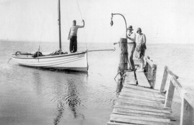 Churchill Island Heritage Farm
Photograph - Photograph of people getting on a sailboat
Churchill Island Heritage Farm has a large photograph collection dating from the nineteenth century. This series provides an insight into the early days of Churchill Island as a Conservation site.Black and White photograph of two people standing on the jetty. The man holds the headstay of the sailboat where another man stands towards the bowCatalogue number written on reverse in pencil.churchill island -
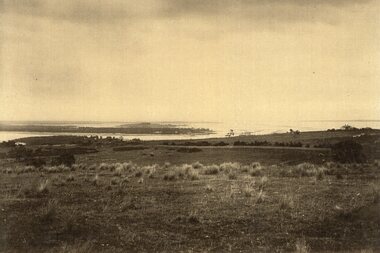 Churchill Island Heritage Farm
Photograph - Photograph of island
Churchill Island Heritage Farm has a large photograph collection dating from the nineteenth century. This series provides an insight into the early days of Churchill Island as a Conservation site.Black and White photograph taken from an elevated area showing a small house on the right hand side. Taken from an island and more can be seen in the background.churchill island, photograph -
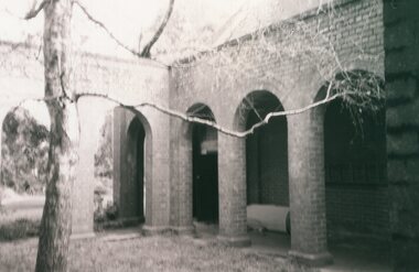 Churchill Island Heritage Farm
Photograph - Photograph of courtyard
Churchill Island Heritage Farm has a large photograph collection dating from the nineteenth century. This series provides an insight into the early days of Churchill Island as a Conservation site.Black and White photograph of a courtyard flanked by a covered walkway lined with arches.Catalogue number written on reversechurchill island, courtyard, photograph -
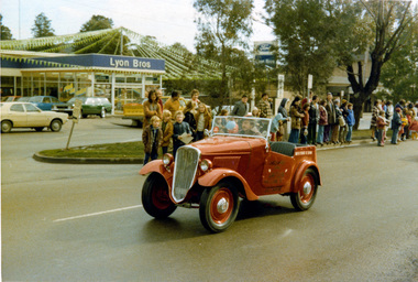 Eltham District Historical Society Inc
Photograph, Ruth H. Pendavingh, Eltham Festival, Main Road, Eltham, 1975c
Photo taken at corner of Arthur Street looking across to Lyon Bros. Ford dealership on site of original Lyons Garage. The new post office is visible to the right of the dealership.Two colour photographs looking diagonally across Main Road, Eltham towards Lyon Bros Ford dealership. One photo shows a 1935 Datsun driving past the gatherered crowd in the medium strip, the other shows a 1974 XB Ford Falcon utility with bunting and a sign on the side advertising ''Sausage Sizzle'eltham, festivals, main road, lyon bros ford, post office -
 Port Melbourne Historical & Preservation Society
Photograph - Mandalay',163 Bridge Street, Port Melbourne, Pat Grainger, Mar 1998
Proposal to demolish and develop two 2 storey houses on the site were taken to Administrative Appeals Tribunal by neighbours and PMH&PS members, December 1997. Appeal was lost.Small colour photo of 163 Bridge Street ('Mandalay') Feb 1998 after it had been approved for demolition for the building of two town housesbuilt environment - domestic, mandalay, bridge street -
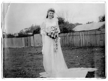 Tarnagulla History Archive
Photograph: Jean Winifred Shipston, Wedding Day, Tarnagulla, 1947
David Gordon Collection. Photograph taken on east side of Commercial Road, Tarnagulla, 1947, at the site of Williams' (then Heraud's) Garden. Jean Gordon is the step-daughter of George Graham. -
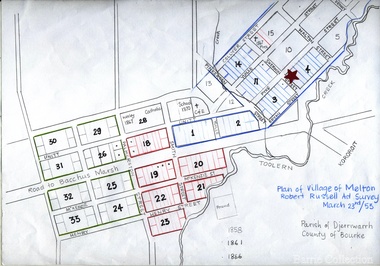 Melton City Libraries
Map, Plan for the Village of Melton, 1853
Site of early village Section numbers 1 - 17 Later became the Flat known as the Common Robert Russell – Surveyor Pinkerton, Sherwin, Bryan, Pyke, Yuille, CollyerMelton Town 1853 Plancouncil -
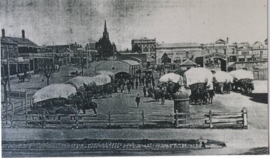 City of Ballarat Libraries
Photograph, Haymarket, Ballarat circa 1906
Ballarat Haymarket circa 1906 viewed from the corner of Armstrong Street North and Mair Streets. This is the site of the Civic Hall. The Royal Highlander Hotel can be seen in the background. haymarket, commerical, ballarat, mair street, armstrong street, royal highlander, hotels, markets -
 Warrnambool RSL Sub Branch
Photograph - Photograph of Australian Servicemen training in Egypt in WW1, 1st Australian Division, Australian Imperial Force EGYPT 1914-1915, unknown
WW1 AIF Training Camp in Egypt prior to deploying to Gallipoli The photograph shows the living conditions (Tents). It also shows the vastness of the site and suggests large numbers of servicemen. These two photographs are historically significant. They demonstrate the conditions that the soldiers in training experienced before they arrived at the front-line. They give the modern viewer some understanding of what it was like in Egypt. It is also very significant because it keeps the memories alive. Professionally framed work, two pictures one above the other. Shows AIF Camp with pyramids in background.Brown frameaif training, gallipoli, 1st australian division, egypt, ww1, australian imperial force -
 Greensborough Historical Society
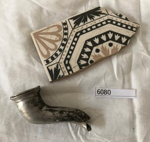
Tile and teapot spout, Tile fragment, and teapot spout, 1940s
The house at 113 Mountain View Road Briar Hill, formerly the home of Bob Barling, scoutmaster in the 1950s, was totally destroyed by fire. These items were salvaged from the site.Two items salvaged from house fire: Tile fragment & teapot spouttile, teapot -
 Glen Eira Historical Society
Plan - a'Beckett Street, 11, East St Kilda
A hand drawn site and floor plan of a building subdivided into 3 flats at 11 a'Beckett Street, East St Kilda; undated but prior to November 2010 by person unknowna’beckett street, east st kilda, flats, plans, garages, outbuildings, residential development -
 Stawell Historical Society Inc
Photograph, Pleasant Creek Special School --- Matron Carter 1955
Pleasant Creek Matron Carter 1955 Former Pleasant Creek Hospital site. Sometimes referred to as Pleasant Creek Special School and sometimes Pleasant Creet Training Centre.stawell -
Federation University Historical Collection
Booklet - Ephemera, M.A.D.E. you look, c2013
MADE was formerly the Eureka Stockade Centre, and was a museum dedicated to democracy located on the site of the Eureka Stockade. Opening on 04 May 2013, it was closed by Council and reinvented as the Eureka Centre. Black booklet outlining the Museum of Australian Democracy at Eureka (MADE)made, museum of australian democracy at eureka -
 Lakes Entrance Regional Historical Society (operating as Lakes Entrance History Centre & Museum)
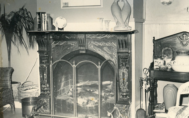
Photograph, Lakes Post Newspaper, 1989c
Formerly Coco's Shoe Shop, known as Mitch's Place developed by Joy Mitchelson. Site has housed a diverse range of businesses. In 2005 bait shop and fishing gear.Black and white photograph of the fireplace in the residence behind a shop at 243 Esplanade, Lakes Entrance, Victoria.houses -
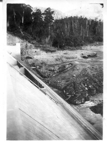 Kiewa Valley Historical Society
12 small black and white photgraphs of Junction Dam and surrounding area, Photo No. 1 c1940, all others c 1948
Junction Dam is a reinforced slab and buttress type construction and was commenced in February, 1940 by Lewis Construction Company. Stiff leg derricks were erected at appropriate locations at the site of the dam and used for the disposal of excavated material and the placing of concrete. A rock crushing and screening plant was established at a site a short distance upstream from the dam site and concrete was supplied from a central mixing plant placed close to the upstream toe of the structure. The SEC took over the construction in April 1942 and the dam wall was completed in March, 1944. Bogong township was commenced in early 1940 with the construction of a workmen's camp housing 96 men, (known as Junction camp). Construction of housing for families commenced shortly after. Forty houses, plus office, workshops, stores and laboratory accommodation were completed over the next 5 years,Of historical significance as a pictorial record of Junction Dam, Lake Guy and Bogong Village, as the photos were taken only 4 years after completion and one photo taken on completion of the dam wall but before the lake was filled with water.12 small black and white photographs of Junction Dam, Bogong Village and surrounding area.Photo 1 - On the back upper edge in pen 'Junction Dam'. Then '12' in pencil, circular stamp, printed in centre 'Print by Willson White Albury'. Photo 2 - On the back upper edge in pen 'Junction Dam October 1948'. Stamp as no. 1 photo. Stamp '998L' lower centre. Photo 3 - on the back upper edge in pen 'Junction Dam October 1948'. Circular stamp with 'Kodak Print' . Lower centre back is stamped 'velox' and '998L'. Photo 4 - upper back, in ink - 'Junction Dam Spion Kopje in background. October 1948'. Stamps as photo no. 4. Photo 5 - upper back, in ink - 'Lake Guy (orange filter) October 1948'. Centre back, in pencil '29' and circular stamp with words 'Print by Willson White Albury'. Photo 6 - upper back edge 'Junction, Bogong from Radio Receiving Shack Dec. 1948'. In pencil '14'. Photo 7 - On back of photo 'View of Mountains from Little Arthur Fire Track October 1948'. Two circular stamps with 'Kodak Print', another two stamps - 'Velox' and '998L'. Photo 8 - On back in ink 'Loone's Store Bogong with Spion Kopje in background. October 1948'. Lower down, stamps 'Velox' and '998L'. Part of circular stamp with one word 'Kodak'. Photo 9 - on back in ink 'Junction Camp, Bogong Village & Lake Guy from Little Arthur Fire Track. October 1948'. Stamped across writing '998L'. Lower down stamped 'Velox' and circular stamp with words 'Kodak Print'. Photo 10 - on back in ink 'Junction Camp & Bogong Village Lake Guy in Foreground. October 1948'. Stamps as photo 9. Photo 11 - on back in ink 'Junction Camp & Bogong Village, Lake Guy in Foreground. October 1948'. Lower stamp '998L'. Photo 12 - 'Junction of Rocky & Pretty Rivers with tennis courts in foreground October 1948' . Circular stamp with words, 'Print by Willson White Albury'. Number '29' written pencil.junction dam; bogong village; kiewa hydro electric scheme; lake guy -
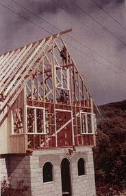 Falls Creek Historical Society
Photograph - Falls Creek Huette
The Falls Creek Huette was created as a result of the ideas, support and persistence of Charles Anton, Founder and First President of the Australian Alpine Club. It opened on the Queen’s Birthday weekend 1963, the same day as the Perisher Huette Work on prefabricating the walls commenced in Melbourne at the start of March 1963. Digging of the foundation trenches commenced on site on 19 March 1963. When the first snow fell on 20 March 1963 some of the construction was temporarily under snow. Fortunately, the site was not buried for long, although the deep mud that developed meant that every sheet of plaster along with all fittings and furniture had to be carried to the lodge from the main road. The first Falls Creek Huette had 14 beds in the bedrooms and an overflow area that could accommodate 6 more persons. It served the Australian Alpine Club until it was sold in 1971 and a much larger lodge was built on another site.These images are significant because they document the construction of an important building at Falls Creek, VictoriaImages from display at Falls Creek Museumfalls creek huette, falls creek lodges, charles anton, australian alpine club -
 Greensborough Historical Society
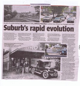
Newspaper Clipping, Diamond Valley Leader, Suburb's rapid evolution, 12/04/2017
Eltham was described as a blossoming township and featured in the top 10 fastest growing Victorian suburbs during the 1960s. This article looks at some historic sites in Eltham and how they look today.News article 2 pages, black text, colour image.eltham, changes over times -
 Greensborough Historical Society
Photograph - Digital image, Marilyn Smith, Mont Park: Ernest Jones Hall, 30/07/2017
Mont Park: Ernest Jones Hall. One of a collection of photographs of the original buildings at the Mont Park Hospital site. This was a combined chapel and entertainment hall, built between 1927-1930.Digital copy of 2 colour photographsmont park hospital, ernest jones hall -
 Nhill Aviation Heritage Centre
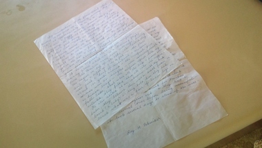
Recollection of Avro Anson crash at Woorak, Approx year 2010
A personal recollection of the Avro Anson crash at Woorak by Mr Roy Schneider who was with his father on their farm near the crash site. Roy was a student of the near by Woorak State School.Roy was at the site immediate after the crash and wrote this recollection a short while before his passing in 2011Hand written by Roy Schneider on two sheets of writing paper -
![Photograph - Digital image, Marilyn Smith, Fallen Soldiers Memorial [base], 17/12/2013](/media/collectors/4f729f5697f83e03086015b8/items/585b6a88d0ce291268060ca7/item-media/585b6ad4d0ce291268061e6c/item-fit-380x285.jpg) Greensborough Historical Society
Greensborough Historical SocietyPhotograph - Digital image, Marilyn Smith, Fallen Soldiers Memorial [base], 17/12/2013
A recent photo of the base of the Fallen Soldiers Memorial. The Memorial was originally sited in Main Street, moved to Lower Park and eventually to its present position in Greensborough War Memorial Park.This memorial was raised by subscription from residents and bears the names of soldiers who were killed in World War 1.Colour digital photographfallen soldiers memorial greensborough, greensborough war memorial park -
 Eltham District Historical Society Inc
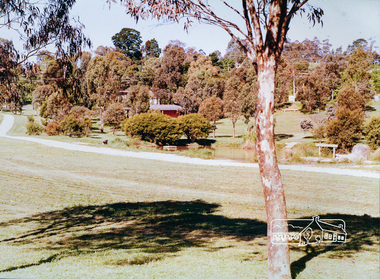
Photograph, Eltham Town Park (previous tip site)
One of a set of display images thought to be produced by the Shire of Eltham c.1979-1987. The Eltham Town Park was a reclaimed tip site. It was later named the Alistair Knox Park Illustrative of services provided by former Shire of ElthamColour photograph 20 x 29 cm mounted on green-painted cardboard 25.5 x 30.5 cmTitle printed on label adhered to board below photograph (replaced June 2017)eltham town park, alistair knox park -
 Sunshine and District Historical Society Incorporated
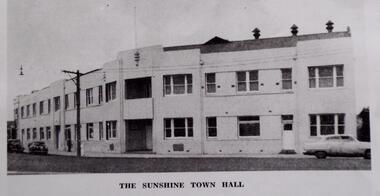
Photograph (1960), SUNSHINE TOWN HALL, 1960
This building once contained the municipal offices and a public Town Hall for the City of Sunshine. The building was demolished and on the site the R.T. Pollard Gardens were established. The Gardens are shown in the second photograph.Although the council built new municipal offices in Alexandra Ave, a Town Hall for public use was never rebuilt. The council considered that there were other halls available, such as the Mariana Hall or school halls, which could be hired for public or council functions. This picture of the Sunshine Town Hall is a copy made from an unknown printed article. The building no longer exists.THE SUNSHINE TOWN HALL Saturday 21st May 1960sunshine town hall, r.t. pollard gardens, council building, ballroom. pollard gardens