Showing 8987 items matching "ah-15"
-
 Greensborough Historical Society
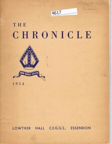
School Magazine, The Chronicle, 1954, 1954_
"The Chronicle" is the annual school magazine of Lowther Hall C.E.G.G.S., this edition is 1954. Inserted inside is Programme and Prize List, Speech night, 15 December 1955.Shirley Black attended Lowther Hall C.E.G.G.S.60 p. black & white print, cream cover, with 4p. leaflet, printed in blue.Shirley Black, Bundooraschools, lowther hall church of england girls' grammar school, shirley black -
 Doncaster RSL Sub Branch
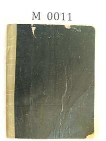
Minute Book, Doncaster Sub-branch First Minute book - 1919
Book includes the Constitution the sub - branch Rules and minutes of 15 meetings from 9th June 1919 to7th February 1920 all in hand writing.Standard school exercise book black outer cover -
 Moorabbin Air Museum
Manual (Item) - Australian Defence Automatic Test Equipment User Group - Second Conference
Description: 15 pages. Published by RAAF. Published Aug1975. AAP 7212.003-33 incl AL1 & 2. Winjeel Weapons loading Level of Importance: World. -
Moorabbin Air Museum
Manual (Item) - Leonides Modification Bulletin 2Nd Edition
Description: 500 pages. Published by General Motors Corporation, Allison Division. Published 15/5/1961. ALL 012 (C2) Level of Importance: World. -
 Clunes Museum
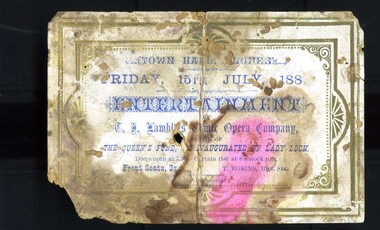
Memorabilia - TICKET
An evening of entertainment provided to support the Queen's Fund, inaugurated by Lady Loch in Queen Victoria's 50th year of reign. This event was held 15 July 1887Cream coloured, blue printing, cardboard ticket to an evening of entertainment in support of the Queen's Fund queen's fund, lady loch -
 Uniting Church Archives - Synod of Victoria
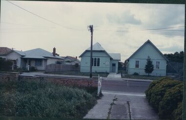
Photograph, undated
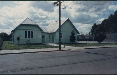
The Methodist (later Uniting) Church in Derrimut St. opened on 15 December 1928. The Church is now known as The Good Shepherd Christian Church (Assemblies of God).Colour photograph of a dwelling, church and hall located at 32 Derrimut St. Albion. methodist church, uniting church, derrimut st. albion, parsonage, good shepherd christian church -
 Uniting Church Archives - Synod of Victoria
Photograph, undated
The Methodist (later Uniting) Church in Derrimut St. opened on 15 December 1928. The Church is now known as The Good Shepherd Christian Church (Assemblies of God).Colour photograph of the Albion Church and hall located at 32 Derrimut St. Albion. methodist church, uniting church, derrimut st. albion, parsonage, good shepherd christian church -
 Hume City Civic Collection
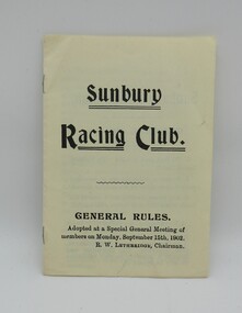
Booklet, SUNBURY RACING CLUB, 1902
A copy of General Rules of the Sunbury Racing Club that were adopted by members on Monday September 15 1902 at a Special General Meeting. The chairman was Mr. R.W.LethbridgeA small four page pamphlet."SUNBURY/RACING CLUB/GENERAL RULES"sunbury, sunbury racing club, sunbury races, sunbury news, sunbury racecourse, social life and customs, boardman, a. f., george evans collection -
 Moorabbin Air Museum
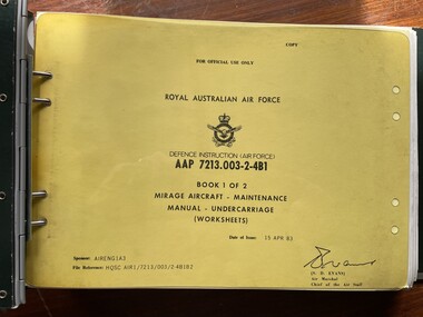
Manual (Item) - (SP) AAP 7213.003-2-4B1 Mirage Aircraft - Maintenance Manual - Undercarriage (Worksheets) Book 1 of 2
Description: 50 pages. Published by RAAF. Published 15/4/1983. AAP 7213.003-2-4B2 Book 2 (PLATES) Level of Importance: World. United States -
 Lakes Entrance Historical Society
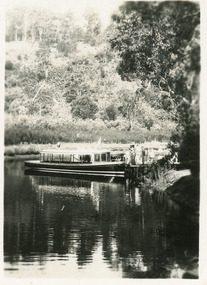
Photograph - MV Blackbird, Bulmers Studio, 1940c
Two copies purchased, One black and white enlargement 25 x 18.5 cm, 1 x sepia print 15 x 10 cmBlack and white small format postcard showing launch, M V Blackbird at Comers North Arm Jetty. Thick vegetation on bank, people on jetty. Lakes Entrance Victoriajetties, waterways, boats and boating, tourism -
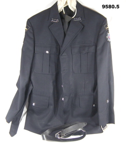 Bendigo Military Museum
Uniform - CORPS OF COMMISSIONAIRES, Fletcher Jones, Unknown
This uniform was issued to “Gerald John Clancy" VX105938. Enlisted 23.7.1942. Discharged 15 April 1946, Rank Cpl in 29/46 Aust. Inf. Bn.1. Jacket. black wool. Four pockets held shut with silver buttons. Front held shut with four silver buttons. Each collar has a silver number badge - 1779. Each arm has a cloth badge marked "Corps of Commissionaires". Each arm also has a 75mm round badge with a 7 pointed star. It is surmounted with a crown. Inside the 'star' is a blue ring with the words "Service - Loyalty - Integrity". Inside the blue ring is a red dot. On that dot are symbols - Eagle, Anchor and a Rifle. Ob the left forearm is a 25 mm cloth badge with a silver letter "R". 2. Belt, wool, black. Silver metal buckle. 3. Trousers, woollen, black. 4. Tie, woollen, black. Red liner, fixed loop for neck. 5. Belt - black leather with silver buckle. Image on the buckle is that of the Corps of Commissionaires.uniform, corps of commissionaires, gerald john clancy -
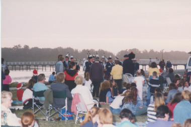 Lakes Entrance Historical Society
Photograph - Lions Carols by Candlelight, 1/12/1999 12:00:00 AM
Also two colour photographs taken at same event one showing RSL Pipe Band performing 04787.1 and .2 10 x 15 cmColour photograph showing crowd getting ready for Lion's Carols by Candlelight. In background is Cunninghame Arm Footbridge, Lakes Entrance Victoriacelebration, bands, rsl clubs -
 Eltham District Historical Society Inc
Photograph, Liz Pidgeon, Heritage Excursion; East of Eltham, 6 Sep 2014, 20 May 2017
Newsletter No. 218, September 2014 September Excursion - East of Eltham Walk In Newsletter No. 197, March 2011, there was a brief history of Crown Allotment 15 Section 5 Parish of Nillumbik (CA 15) a parcel of land of a quarter of a square mile extending from Eucalyptus Road to Reynolds Road at the eastern extremity of Eltham. From the 1940s it was known as Stokes orchard. In later years it has been subdivided for residential purposes but leaving significant areas as power line and water supply reserves and bushland reserves that are habitat for the threatened For our excursion on 6th September we intend to walk through CA 15 to a bushland reserve east of Reynolds Road. The walk will traverse the boundary between suburban Eltham and the non-urban areas to the south and east. This is a pleasant walk through residential areas and bushland. Along the way we will discuss the early and more recent history of CA 15 as well as local natural history and geology. This walk is about 3.5 km in length and will take 2 to 2.5 hours. It will start at 2pm at the corner of Eucalyptus Road, Pitt Street and Nyora Road.Born Digitaleltham east, eltham district historical society, heritage excursion, activities, nyora road, reynolds road, gum tree road reserve, diosma road, stokes orchard, eucalyptus road -
 Eltham District Historical Society Inc
Photograph, Liz Pidgeon, Heritage Excursion; East of Eltham, 6 Sep 2014, 20 May 2017
Newsletter No. 218, September 2014 September Excursion - East of Eltham Walk In Newsletter No. 197, March 2011, there was a brief history of Crown Allotment 15 Section 5 Parish of Nillumbik (CA 15) a parcel of land of a quarter of a square mile extending from Eucalyptus Road to Reynolds Road at the eastern extremity of Eltham. From the 1940s it was known as Stokes orchard. In later years it has been subdivided for residential purposes but leaving significant areas as power line and water supply reserves and bushland reserves that are habitat for the threatened For our excursion on 6th September we intend to walk through CA 15 to a bushland reserve east of Reynolds Road. The walk will traverse the boundary between suburban Eltham and the non-urban areas to the south and east. This is a pleasant walk through residential areas and bushland. Along the way we will discuss the early and more recent history of CA 15 as well as local natural history and geology. This walk is about 3.5 km in length and will take 2 to 2.5 hours. It will start at 2pm at the corner of Eucalyptus Road, Pitt Street and Nyora Road.Born Digitaleltham east, eltham district historical society, heritage excursion, activities, nyora road, reynolds road, gum tree road reserve, diosma road, stokes orchard, eucalyptus road