Showing 3906 items matching "bricker"
-
 Bendigo Historical Society Inc.
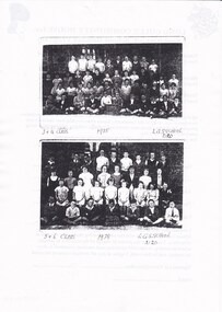
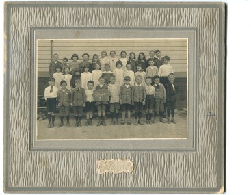
Photograph - LONG GULLY HISTORY GROUP COLLECTION: SCHOOL PHOTOS 1935 & 1938
Page with two black and white copies of photos of the 3 & 4 Class of the Long Gully School 2120 taken in 1935 and Class 5 & 6 taken in 1938. Boys in the front row are holding a blackboard with the name on it. Photos not very clear. Children are in front of a brick building. Part B has some of the names of the children written on it. On the back is a permission form for the 1998 School Holiday Program. Paper with the names of the 1938 Class of the Long Gully School. They are: Back - l - R - Tommy White, Jack Shadford, Colin Neyland, Tammy Kendall, Alan Roberts, Frank Fraser, Frank Button, Noel Evans, Percy Winberg, 3rd Row L - R - Reg Ennor, Dan Banninger, Dorothy Hecker, Bessie Rasmussen, Elsie Clymo, Val Polglaze, Shirley White, Evon Davey, Fay Pearce, Frank Bruhn, Noel Waterman, 2nd Row L - R - Rex Harris, Stan Anderson, Lois Faye Horwood, Betty Slater, Valda Kitt, Clymo, Lois Green, Adelaide Waterman, Ray Wilson, Len Leggo, Lachlan Neyland, Frong Row - Ray Rasmussen, Lance Hester, Fred Salter, Norm Grenfell, Max Lambert, Button, Ray White, Max Ellis, Des Davey. On the back is House Reports 1997 - 1998.bendigo, history, long gully history group, the long gully history group - school photos 1935 & 1938, long gully state school 2120 class 3 & 4 1935, long gully state school 2120 class 5 & 6 1938 -
 Bendigo Historical Society Inc.
Document - ALBERT RICHARDSON COLLECTION: SECRETARY FOR MINES ANNUAL REPORT 1911
Three page typed report titled ' Notes on diagram showing pitch lines, Bendigo'. Longitudinal sections along the lines of reefs or anticlines within the 8 mile block at Bendigo are shown in a diagram' (diagram not included with notes) Mines and reef lines mentioned in the report are : New Chum line, New Chum Railway mine, Catherine United mine, Hercules and Energetic mine, Garden Gully, Hustlers and Redan, Sheepshead Reef, Sea Mine, Garden Gully, Miller's line of reef and Bendigo Development Mine. The 'old stacks' or chimneys, on Bendigo are described. 'Among the earliest of the stacks built at Bendigo in connexion with Quartz crushing plant, are the two figured in this Annual report No 1 was situate in Sailor's Gully but was demolished about three years ago. This, if not the first, must have been one of the first built, for it had a stone inserted on which chiselled the date 1854. It was built altogether of rough masonry. The other, No. 2, is still standing at the Sheepshead line and was apparently of later date, the upper portion being of brick. They are intersting landmarks of an era that is rapidly passing.' Map attached to report showing location of stacks. Stack at Sailors Gully was near the corner of Murchison Street and Lester Street. The stack at Sheepshead ( Deborah Triangle area) was near the intersection of Belle Vue Road and Adam Street.bendigo, mining, pitch lines bendigo -
 Bendigo Historical Society Inc.
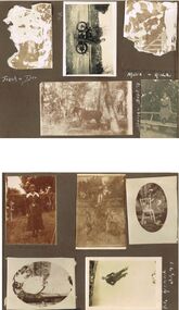
Photograph - HILDA HILL COLLECTION: BLACK AND WHITE PHOTOS, 1917-1924
Series of Black & White Photos Total 6 Hill Family & Friends During the First World War and after. Rita, wearing a dark dress with white collar and holding a dark coloured hat, background is large brick structure with windows to right and small section of veranda, pal tree, Railway Reserve Kyneton 1918. Man and two women wearing white dresses and dark hats, man wears dark suit white shirt and dark tie with his back against a large wheel, white sheet on ground between them and indistinguishable articles on sheet, Hibernian Picnic Axedale November 13th 1918. Group of young girls and boys all dressed in light coloured clothing gathering Botanical gardens January 1917, Miss N. Linnane reclining on cane lounge chair on verandah, weatherboard wall of house, verandah post, rock garden edging in foreground, May 1918. Monte Video Property Queensland Jeff, dressed in dark trousers and white shirt, holding a skinned rabbit, water tank in background, wire fence, July 1924. Father & Mother, Father wears a grey suit with white shirt and dark tie, Mother seated is wearing a dark dress with striped collar and white blouse, 'The Ranche' Mollison Street Eppalock.Hilda Hill Personal Collectionaustralia, history, post war life -
 Kew Historical Society Inc
Plan, Melbourne & Metropolitan Board of Works : Borough of Kew : Detail Plan No.1301, 1910
The Melbourne and Metropolitan Board of Works (MMBW) plans were produced from the 1890s to the 1950s. They were crucial to the design and development of Melbourne's sewerage and drainage system. The plans, at a scale of 40 feet to 1 inch (1:480), provide a detailed historical record of Melbourne streetscapes and environmental features. Each plan covers one or two street blocks (roughly six streets), showing details of buildings, including garden layouts and ownership boundaries, and features such as laneways, drains, bridges, parks, municipal boundaries and other prominent landmarks as they existed at the time each plan was produced. (Source: State Library of Victoria)This plan forms part of a large group of MMBW plans and maps that was donated to the Society by the Mr Poulter, City Engineer of the City of Kew in 1989. Within this collection, thirty-five hand-coloured plans, backed with linen, are of statewide significance as they include annotations that provide details of construction materials used in buildings in the first decade of the 20th century as well as additional information about land ownership and usage. The copies in the Public Record Office Victoria and the State Library of Victoria are monochrome versions which do not denote building materials so that the maps in this collection are invaluable and unique tools for researchers and heritage consultants. A number of the plans are not held in the collection of the State Library of Victoria so they have the additional attribute of rarity.Original survey plan, issued by the MMBW to a contractor with responsibility for constructing sewers in the area identified on the plan within the Borough of Kew. The plan was at some stage hand-coloured, possibly by the contractor, but more likely by officers working in the Engineering Department of the Borough and later Town, then City of Kew. The hand-coloured sections of buildings on the plan were used to denote masonry or brick constructions (pink), weatherboard constructions (yellow), and public buildings (grey). Throughout its history, the land in what is known today as Studley Ward of the City of Boroondara has been subject to continuing subdivision. This is evident in Plan 1301, where later hands have modified the original map to include streets created subsequent to the printing of the plan in 1904. Other annotations such as the ‘Reserved for Road Purposes’ beside the Yarra never eventuated. The plan continued to be modified to at least 1953, when a later hand noted that a particular site was ‘Property site P. McIntyre house’ in Swinton Avenue. Two significant houses in the area are outlined on the plan: ‘Swinton’ on the corner of the streets then named Effey and Maud Streets (now Swinton Avenue) and ‘Fairhaven’ [unnamed] in Stevenson Street. The gardens of the two David Syme owned mansions of ‘Blythswood’ and ‘Rockingham’, stretching down to the River Yarra, are also represented.melbourne and metropolitan board of works, detail plans, mmbw 1301, cartography -
 Royal District Nursing Service (now known as Bolton Clarke)
Photograph - Photograph, black and white, Barry Sutton, 20.07.1972
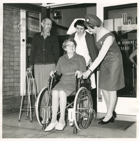
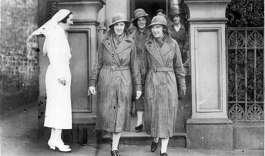
This RDNS Liaison Sister is reassuring a lady who is being discharged from Mount Royal Rehabilitation Hospital regarding the visits she will receive from RDNS Sisters in her home. The Liaison Sister had previously visited the lady in the Ward to ascertain the care she would require at home and this information had been passed to the appropriate RDNS Centre and to the Sister who would be visiting the lady in her home. The RDNS Sister is wearing her RDNS winter uniform of a blue/grey skivvie under a blue/grey winter material herringbone V neck tunic style frock. She is wearing her blue/grey herringbone winter material hat.Liaison had occurred between doctors and the Trained nurses (Nurses) of the Melbourne District Nursing Society (MDNS), from its inception in 1885. This increased when Midwifery was introduced in August 1893 with close liaising with the Women’s Hospital. As District nursing grew it was recognized that closer liaising between many Public Hospitals would be beneficial, for not only the MDNS, later called Royal District Nursing Service (RDNS), Trained nurses (Sisters), but also for the patients and the hospitals. In August 1964 a Liaison Officer commenced at the Alfred Hospital. This soon increased to Liaison Officers working full time at several Public Hospitals. At the time of a patient’s discharge, the Liaison Sister forwarded information on their diagnosis and instructions regarding the care required at home to the appropriate RDNS Centre, and in turn the attending District Sister wrote a report of progress and any queries to the hospital Doctor, via the Liaison Sister, at the time the patient was attending outpatients. Any new instructions were then sent back to the District Sister. Liaising also occurred between District field staff and Doctors when patients were referred by General Practitioners and did not attend a Hospital. Rehabilitation of patients to insure they were able to live independently in their own homes was at the forefront of care given by the RDNS Sisters.On the right of the black and white photograph is a Royal District Nursing Service (RDNS) Sister, who is wearing her uniform hat over her short curled hair, and a pale skivvie under a V neck tunic style grey dress. She is leaning forward with her left hand on the arm of a wheelchair, and is smiling at a lady, who has short curly hair; is wearing glasses and grey frock with a belt, and is sitting in wheelchair. She is holding the tops of walking sticks with both her hands; the foot of the sticks are resting on the ground. The footplates of the wheelchair are open and the lady has her feet on the ground. To her left stands a gentleman who has short dark hair and is wearing a buttoned up dark cardigan over a light coloured shirt, peaks showing, and light trousers. He is holding a 4 prong stick in his right hand and is looking at the lady. A Hospital Sister, who is wearing a dark cape over her white uniform and a white veil over her short dark curly hair is standing behind the wheelchair looking down at the lady. In the background, part of a brick wall can be seen on the left and to the right of this an open glass door and to its right is a closed glass door with writing on it.Barry Sutton Photographer's stamprdns, royal district nursing service, rdns uniform, rdns liaison, rdns rehabilitation -
 Royal District Nursing Service (now known as Bolton Clarke)
Photograph - Photograph, black and white:, 1934
The District nurses are leaving from their Melbourne District Nursing Society (MDNS) Nurses Home, which was situated at 39 Victoria Parade, Collingwood. Their MDNS uniform dresses and coats depicted are grey, and a red Maltese cross is attached to the centre of the headband on their grey brimmed hats. The Sisters will visit MDNS patients and provide nursing care to them in their homes.From its founding in 1885 until 1891 the Trained nurses (Nurses) of the Melbourne District Nursing Society (MDNS) worked from their own homes which were located in the vicinity of their areas (districts). In November 1891 MDNS was able to rent a two story terraced house at 66 Cardigan Street, Carlton, at £65 a year, which contained accommodation for three Nurses and one pupil nurse as well as being used as their Headquarters. They left from their Nurses Home each morning and returned at the end of their shift to write up their book work before retiring for the day. Three years later they moved into a larger terraced house at 49 Drummond Street Carlton which was rented at ‘a very moderate rental’. There was a Board room, apartments for the Nurses and pupil nurse, a large dispensary which patients could attend each evening to have prescriptions signed and bottles refilled with ‘homely remedies’ and elixirs, which were administered for e.g. to Consumptive cases. Doctor’s prescriptions were filled at the Pharmacy. Cupboards containing donated blankets and bedclothes for needy patients were kept in this room, and it was here where the Nurses kept their equipment and nursing bags which were refilled at the end of each shift ready for any emergency, and for the next day. A list of Doctors the Nurses could call was kept by the telephone. The home also had a kitchen where nourishing soup was made and distributed twice a week to the needy. Milk was also distributed when needed. In 1902 they moved into rented premises at 188 Leicester Street, Carlton and two years later, in 1904, to premises at 5 Royal Terrace, Nicholson Street, Fitzroy. They remained there for ten years and an Auction of furniture was held before their next move giving an idea of some of the contents: - Carpets, linoleum, walnut and oak sideboards, dining tables, walnut dining suite, Vienna chairs, walnut bedroom suite, cedar wardrobes, chests of drawers, duchess chests, bedsteads and bedding and general furnishings were for sale. In June 1914 at last the Society had sufficient funding to purchase their own terraced premises, ‘Floraston’ 39 Victoria Parade, Collingwood which was their Headquarters and Nurses Home. In 1926 the After-Care Home for recovering patients, (later called After-Care Hospital) was built by the Society next door, at 45 Victoria Parade; the District nurses continued to live at No. 39. In November 1953 the District Nursing Division moved into their new Headquarters and Nurses Home at 452 St. Kilda Road, Melbourne. In 1957 the two divisions legally separated and the District division became the Melbourne District Nursing Service. As District expanded, and now with outlying districts to service, and with a fleet of District cars, their trained nurses (Sisters) lived in their own homes and visited their closest District Centre each morning to collect their work for the day, and returned at the end of their shift to do their administrative work. A small black and white photograph showing a side on view of Matron Lydia Shaw who is smiling. She is standing outside the Nurses Home of the Melbourne District Nursing Society (MDNS), and is wearing a white long sleeved belted uniform dress, white stockings, shoes, and a veil over her short dark hair.. She is standing to the left, outside the front gate of the building watching a group of district nurses about to leave the Home. The group are on a path behind the four trained nurses (Sisters) most visible who are dressed in grey belted long sleeved coats which have lapels. They are wearing grey brimmed hats with a Maltese cross in the centre, flesh coloured stockings and black shoes. The first two Sisters are side by side and have just stepped onto the pavement; the one to the right is smiling and slightly turned toward Matron Shaw. Under their coats, both these Sisters are wearing grey scarves around their necks. There is a square concrete column behind Matron Shaw, and another to the right of the nurses. From the right column three metal vertical fence bars are seen with shrubs behind them. Part of a building and doorway can be seen behind the nurses. A brick wall and path is seen on the far left of the photograph.The date 1934 as well as the name of Matron Shaw, Sister Jones and Sister Tupper were hand written on the back of the photographnurses, matron, uniform, melbourne district nursing society, mdns, nurses home, rdns, royal district nursing service, matron lydia shaw, sister dorothy tupper, sister jones -
 Bendigo Historical Society Inc.
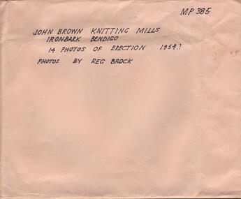
Photograph - HANRO COLLECTION: PHOTOGRAPHS OF THE ERECTION OF JOHN BROWN KNITTING MILLS, 1954
John Brown Industries became a listed company in 1951 and acquired Star Hosiery Mills factory and its Bendigo offshoot. In 1955 they purchased a 4 acre site at Ironbark to build a new mill. This was completed in a record 19and a half weeks and the mill was handed over in Sept. 1956.Photographs of the Erection of John Brown Knitting Mills: A brown envelope which had hand printed writing in black ink. On the right hand top is *MP385*. In the middle *John Brown Knitting Mills Ironbark Bendigo. 14 Photos of Erection 1954? Photos by Reg Brock*. Attached to the envelope is a torn piece so paper which has been hand written in blue ink *John Brown & Welmar* Knitwear Socks & Dress wear The Finest in the Land. Made on the site of Bendigo's Richest Gold Mine, *The Little 180*. Inside the envelope is a collection of black and white photos of the erection of the John Brown Knitting Mills on Marong Road in Ironbark Bendigo. 14 Photos in total showing various views of the construction site. Workmen on the site laying bricks, constructing the steel building and trucks delivering steel etc. A crane truck with *General Carriers Bendigo* printed on the side door. On the back of each photo is *MP385*. The Circular stamp in blue ink of the Royal Historical Society of Victoria Bendigo Branch and a cream photographers label with a blue band top and bottom with *Reg. V. Brock of Bendigo in the bands. In the centre of the label in blue print is *No.... B1098. pos.... Additional copies may be obtained at any time by quoting this number. Box 116A.Reg. V. Brock of Bendigo.photograph, building, john brown, john brown knitting mills -
 Eltham District Historical Society Inc
Photograph - Digital Photograph, Alan King, Sign: Clara Southern, Heidelberg School Artists Trail, Main Road, Research, 2008
Warrandyte artist, Clara Southern, features on the Artists Trail. Published: Nillumbik Now and Then / Marguerite Marshall 2008; photographs Alan King with Marguerite Marshall.; p189 Since early in the 20th century this district has attracted artists and other creative people. So much so, that Eltham has been compared to the Left Bank in Paris, New York’s Greenwich Village and London’s Bloomsbury. That is until the 1970s when Eltham rapidly expanded into a suburb. However many artists still flourish not only in Montsalvat, Dunmoochin and the Bend of Islands but elsewhere in Nillumbik. Some artists who have worked or lived in Nillumbik are well-known nationally and internationally. Artists are attracted to the hilly district’s subtle colours, unique light and the Yarra River and Diamond Creek. The railway’s extension to Eltham in 1902 brought artists to paint for the day or to camp. Then many settled in Eltham, perhaps also because the poor quality land, far from the city, was cheap. Following World War Two they found they could build houses and studios cheaply by making their own mud-bricks. The flexible material, with its warm tones blending into the bush, also satisfied their aesthetic sensibilities. As early as 1900, Will Longstaff, known for his painting The Ghosts of Menin Gate at the National War Memorial in Canberra, lived at Stanhope in Peter Street, Eltham, later to become the home of intellectuals Clem and Nina Christensen. Members of Australia’s first significant art movement, the Heidelberg School of Artists, painted in Eltham, Warrandyte and Diamond Creek. Walter Withers lived at the corner of Bolton and Brougham Street, Eltham and taught Sir Hans Heysen, who for a short while stayed with the Withers family. In Warrandyte were Clara Southern, whom Frederick McCubbin taught at the National Gallery School and Penleigh Boyd, who is represented in all Australian state galleries and the National Collection in Canberra. May Vale, daughter of politician William, lived in Diamond Creek. With Jane Price they feature on the Heidelberg School Artists Trail, part of which runs through Nillumbik. The trail includes signs each displaying a reproduction of a painting by an artist and located near where the artist lived or painted. In Nillumbik the trail includes parts of Warrandyte, Eltham in the Alistair Knox Park, Main Road shopping precinct and Wingrove Park, the Research walking track on Main Road and the Diamond Creek Reserve. In 1916 artist William ‘Jock’ Frater lived at the corner of Arthur and Bible Streets, Eltham. Before then, Frater, with other artists including Percy Leason (who moved to Eltham in the mid 1920s) painted in Eltham on weekends. They camped near Bible and Pitt Streets and along the Diamond Creek where the Eltham Retirement Centre now stands.4 In 1921, painter Peter Newbury (father to painter David Newbury, who was born in Eltham) moved to Cromwell Street, Eltham. Max Meldrum, the first Australian painter to formulate a consistent theory of art largely based on tone,5 taught local artists Alan Martin, Clarice Beckett, Peter Glass and Justus Jörgensen. Meldrum visited Eltham then rented a house there for 18 months opposite Wingrove Park. In 1934, artist and architect Justus Jörgensen and his doctor wife Lil and friends built Montsalvat, the artists’ colony. Montsalvat has played an important part in attracting artists to Eltham and its mud-brick, pisé, stone and recycled building materials has had a major influence on Eltham’s built environment. Jörgensen’s students who also helped him build Monstalvat included Arthur Munday, Lesley Sinclair, Helen Lempriere, Joe Hannan, Helen, Sonia and jeweller/sculptor, Matcham Skipper. Among artists who visited Montsalvat were Clifton Pugh and Angry Penguins’ artists Albert Tucker and Arthur Boyd. Some who painted after World War Two were Alan Martin of Eltham and Warrandyte artists Frank Crozier and Harry De Hartog6, one of Melbourne’s first painters influenced by Cubism.This collection of almost 130 photos about places and people within the Shire of Nillumbik, an urban and rural municipality in Melbourne's north, contributes to an understanding of the history of the Shire. Published in 2008 immediately prior to the Black Saturday bushfires of February 7, 2009, it documents sites that were impacted, and in some cases destroyed by the fires. It includes photographs taken especially for the publication, creating a unique time capsule representing the Shire in the early 21st century. It remains the most recent comprehenesive publication devoted to the Shire's history connecting local residents to the past. nillumbik now and then (marshall-king) collection, clara southern, main road, research (vic), heidelberg school artists trail -
 Federation University Historical Collection
Pamphlet, Jeff Zilles, Old Curiosity Shop, c1980s
The Old Curiosity Shop was q house was built by bricklayer James Warwick, and his wife Caroline, with construction beginning around 1863. It was opened to the public in 1895. What is significant? Construction of the house later known as the Old Curiosity Shop commenced about 1863, the year bricklayer, James Warwick obtained a miner's right for a residential block on the edge of the exhausted Eureka diggings in the newly proclaimed municipality of Ballarat East. James built a modest 4-roomed timber and brick house for his expanding family and continued in the bricklaying trade until retiring around the early 1880s. By then he was pursuing his gardening interests in the local Horticultural Society and was supervising the gardens of many East Ballarat residents. It was during these years that his gardening and building interests converged to find expression in the marvellous permutations of decoration that extend over the house and garden. Using cast-off crockery, glass, ceramic figurine and mirror shards, shells, wallpaper samples, architectural ornament and slag, a place was found for all manner of things, large and small. Children would bring broken china dolls and bits of crockery, and the patient mosaic work preoccupied James and his wife Caroline for the rest of their lives. The work has its origins in the grottoes and shellhouses that ornamented the gardens of large English estates from the 1730s. In the few years before James' death in 1898, the house had become known as the 'Old Curiosity Shop', inspiring associations with the Charles Dickens novel of the same name. By then professional photographs had also been taken and thousands of tourists were visiting it yearly. Caroline obtained copyright for 2 of the photos and began issuing her own postcards before she died in 1903. The Shop passed to their son Charles and then to a succession of owners who added their own mythology to the story of the Warwicks and their work. After attracting tourists for more than 100 years, the Shop closed to the public in 1999. (Vitorian Heritage Database)Brochures on the Old Curiosity Shopold curiosity shop, warwick, ballarat east, james warwick, caroline warwick -
 Eltham District Historical Society Inc
Photograph, Eltham Christian School, severely damaged by a deliberate fire, 10 October 1989, 1989
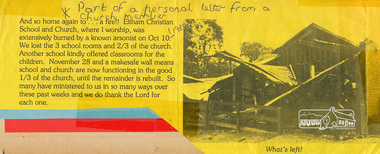
Part of a personal letter from a church member printed on yellow paper with a black and white photograph. Transcription: "And so home again to .. a fire!! Eltham Christina School and Church, where I worship was extensively burned by a known arsonist on Oct 10 (1998). We lost tthe 3 school rooms and 2/3 of the church. Another school kindly offered classrooms for the children. November 28 and a makesafe wall means school and church are now functioning in the good 1/3 of the church, until the remainder is rebuilt. So many have ministered to us in so many ways over these past weeks and we do thank the Lord for each one." The Stokes family settled in this area of Eltham in the 1940s and were associated with the Eltham Christian Church. In the 1970s this church had met in temporary premises in Eltham. Lots of the original 1920s subdivision remained south of Nyora Road and a number of these lots were utilized for the Eltham Christian School, which was established by the Eltham Christian Church in 1981. The school operated on this site until 2000. The premises were owned by the Nillumbik Community Church who were in operation till November 2010 when the Eltham Baptist Church commenced a lease arrangement until the site was purchased by them in April 2012. The building is constructed of brick and timber with a balcony on two sides that looks over an expanse of grass. Sources: STOKES ORCHARD – AN INCOMPLETE HISTORY February 28, 2015 http://www.elthamhistory.org.au/ Australian Christian Church Histories - Eltham Baptist Church http://www.churchhistories.net.au/church-catalog/eltham-vic-baptist/ From a magnetic spiral bound photo album featuring a series of photographs (some cropped) with captions relating to the staff, students and activities of the Eltham Christian School which operated as part of the Eltham Christian Church at Nyora Road, Eltham. See also entries for each photograph.Typed letter printed on yellow paper with a black and white photographeltham christian school, nyora road, fire damage -
 Eltham District Historical Society Inc
Photograph, John Collins, Shillinglaw Cottage on its original site, 17 Oct. 1963
Shilinglaw Cottage in its original location on Main Road Eltham with the “Shillllinglaw trees”. This image was taken shortly before its relocation. Believed to be have been taken by John Collins, 17 Oct 1963 as per other images held by the State Library of Victoria Author / Creator: John T Collins 1907-2001 , photographer. J.T. Collins Collection, La Trobe Picture Collection, State Library of Victoria. Shillinglaw Cottage is significant to Eltham’s local history. It is one of the earliest known buildings still in existence. Records suggest that the cottage was built circa 1859 by a man named Cochrane, believed to be Thomas Cochrane, in conjunction with George Stebbings though it is not known what Stebbings’s contribution was. It is made from hand made bricks laid in a Flemish bond pattern. In the 1960s it was marked for demolition to make way for the construction of new council buildings but a community campaign saved the cottage and it was re-located. It is believed Stebbings owned the cottage between 1874 and 1888. According to Margaret Ball’s (2017) book Shillinglaw Family of Eltham 1660-2007, Thomas Cochrane and family lived there from 1867 to 1874 however this is contrary to the records of assessable rates levied by the Eltham District Road Board, established in 1858, which shows Cochrane was the owner occupier (in Little Eltham) of approximately 25 acres of cultivated land and 25 acres of pastureland upon which a hut was sited in 1860. It is suspected that George Stebbings may have acquired the property from Cochrane in 1874 as it is noted that he had a tenant for a period, James Rossiter, who was the editor for the Evelyn Observer in Kangaroo Ground in 1874 (LATE SHIRE OFFICE AT KANGAROO GROUND (1934, February 16). Advertiser (Hurstbridge, Vic. : 1922 - 1939), p. 5. Retrieved February 25, 2022, from http://nla.gov.au/nla.news-article56743657). In 1881 Phillip Shillinglaw became the ratepayer for the cottage though Stebbings retained ownership until 1888 at which time it was transferred to Shillinglaw. This photo forms part of a collection of photographs gathered by the Shire of Eltham for their centenary project book, "Pioneers and Painters: 100 years of the Shire of Eltham" by Alan Marshall (1971). The collection of over 500 images is held in partnership between Eltham District Historical Society and Yarra Plenty Regional Library (Eltham Library) and is now formally known as 'The Shire of Eltham Pioneers Photograph Collection.' It is significant in being the first community sourced collection representing the places and people of the Shire's first one hundred years.Digital image 4 x 5 inch B&W Negsepp, shire of eltham pioneers photograph collection, eltham, shillinglaw cottage, shillinglaw trees, significant tree -
 Orbost & District Historical Society
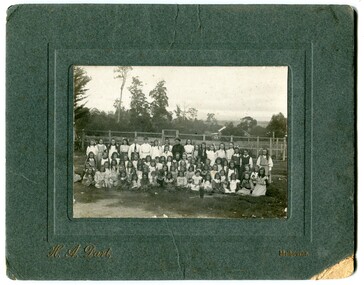
black and white photograph, H.A. Dart, C1890
"The 19th of March 1886 proved an important day in the lives of many early settlers in the Orbost area, because on this day the Orbost State School opened. The fact that the school had first operated temporarily in a leased building, and on a half-time basis with SS2745 Jarrahmond, did not dampen the enthusiasm of the local inhabitants as they saw their offspring commence their education under the guidance of HT Campbell Mackay. However he remained in charge only until 12th of May 1886. The second HT, John Rowe, served until 1908. On 30th of June 1887, a portable room was provided; it being brought to the area by schooner. The school now had accommodation for 30 pupils; the teacher's welfare was considered because quarters of two rooms were attached. As the population increased so did the needs of the school. This was reflected in the provision of a larger classroom in 1898. During 1910-11 the first approaches were made to the Department for the establishment of a HES in Orbost and this became a reality in 1912. Orbost HES supplied post-primary education in the district until a high school was built in 1948. When fire destroyed the school in 1941 local halls were used as classrooms until a new school was built. Work was quite rapid and a new brick structure was opened by the Hon. A. E. Lind, MLA, on 13th of February 1942. This new building was a fine type of school of which both the pupils and the HT Leslie Collins were indeed proud. But Orbost continued to develop and the new school was soon overtaxed. This resulted in the erection of two Bristol classrooms in 1947. By 1950, when the school population had reached 500 pupils the opening of the new school at Orbost North was welcomed by all concerned. In 1963 the Department purchased land diagonally opposite the school and developed it as a playing area. In 1965 two LTCs were opened in November, and in October 1968 the Brodribb School building was moved to SS2744 Orbost for use as a general purpose room." This item is associated with the history of education in Orbost.A black / white photograph of a group of students, some kneeling, some sitting, in a school yard. It is framed in grey buff cardboard with a photographer's stamp at the bottom.H. A. Dart Melbourne in gold print at the bottom.photograph-orbost-state-school -
 Orbost & District Historical Society
black and white photograph, C1900
The 19th of March 1886 proved an important day in the lives of many early settlers in the Orbost area, because on this day the Orbost State School opened. The fact that the school had first operated temporarily in a leased building, and on a half-time basis with SS2745 Jarrahmond, did not dampen the enthusiasm of the local inhabitants as they saw their offspring commence their education under the guidance of HT Campbell Mackay. However he remained in charge only until 12th of May 1886. The second HT, John Rowe, served until 1908. On 30th of June 1887, a portable room was provided; it being brought to the area by schooner. The school now had accommodation for 30 pupils; the teacher's welfare was considered because quarters of two rooms were attached. As the population increased so did the needs of the school. This was reflected in the provision of a larger classroom in 1898. During 1910-11 the first approaches were made to the Department for the establishment of a HES in Orbost and this became a reality in 1912. Orbost HES supplied post-primary education in the district until a high school was built in 1948. When fire destroyed the school in 1941 local halls were used as classrooms until a new school was built. Work was quite rapid and a new brick structure was opened by the Hon. A. E. Lind, MLA, on 13th of February 1942. This new building was a fine type of school of which both the pupils and the HT Leslie Collins were indeed proud. But Orbost continued to develop and the new school was soon overtaxed. This resulted in the erection of two Bristol classrooms in 1947. By 1950, when the school population had reached 500 pupils the opening of the new school at Orbost North was welcomed by all concerned. In 1963 the Department purchased land diagonally opposite the school and developed it as a playing area. In 1965 two LTCs were opened in November, and in October 1968 the Brodribb School building was moved to SS2744 Orbost for use as a general purpose room. ( info. Schools East Gippsland) This item is associated with the history of education in Orbost.A black / white photograph framed by a grey buff card. It shows grade three students standing in front of a wooden school building.education-orbost orbost-state-school -
 Orbost & District Historical Society
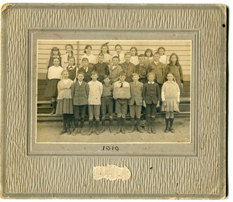
black and white photograph, Wilson, Les G, 1919
The 19th of March 1886 proved an important day in the lives of many early settlers in the Orbost area, because on this day the Orbost State School opened. The fact that the school had first operated temporarily in a leased building, and on a half-time basis with SS2745 Jarrahmond, did not dampen the enthusiasm of the local inhabitants as they saw their offspring commence their education under the guidance of HT Campbell Mackay. However he remained in charge only until 12th of May 1886. The second HT, John Rowe, served until 1908. On 30th of June 1887, a portable room was provided; it being brought to the area by schooner. The school now had accommodation for 30 pupils; the teacher's welfare was considered because quarters of two rooms were attached. As the population increased so did the needs of the school. This was reflected in the provision of a larger classroom in 1898. During 1910-11 the first approaches were made to the Department for the establishment of a HES in Orbost and this became a reality in 1912. Orbost HES supplied post-primary education in the district until a high school was built in 1948. When fire destroyed the school in 1941 local halls were used as classrooms until a new school was built. Work was quite rapid and a new brick structure was opened by the Hon. A. E. Lind, MLA, on 13th of February 1942. This new building was a fine type of school of which both the pupils and the HT Leslie Collins were indeed proud. But Orbost continued to develop and the new school was soon overtaxed. This resulted in the erection of two Bristol classrooms in 1947. By 1950, when the school population had reached 500 pupils the opening of the new school at Orbost North was welcomed by all concerned. In 1963 the Department purchased land diagonally opposite the school and developed it as a playing area. In 1965 two LTCs were opened in November, and in October 1968 the Brodribb School building was moved to SS2744 Orbost for use as a general purpose room. ( Info. from Schools East Gippsland) This item is associated with the history of education in Orbost.A black / white photograph on a grey buff cardboard frame. It is of a group of students standing outside the Orbost State School building. One child holds a sign reading "Form F". There is a photographer's label at the bottom.on back - "Alen Roach" on front - "1919" education-orbost orbost-state-school -
 Orbost & District Historical Society
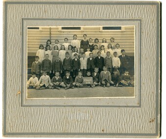
black and white photograph, Wilson, Les G, 1919
The 19th of March 1886 proved an important day in the lives of many early settlers in the Orbost area, because on this day the Orbost State School opened. The fact that the school had first operated temporarily in a leased building, and on a half-time basis with SS2745 Jarrahmond, did not dampen the enthusiasm of the local inhabitants as they saw their offspring commence their education under the guidance of HT Campbell Mackay. However he remained in charge only until 12th of May 1886. The second HT, John Rowe, served until 1908. On 30th of June 1887, a portable room was provided; it being brought to the area by schooner. The school now had accommodation for 30 pupils; the teacher's welfare was considered because quarters of two rooms were attached. As the population increased so did the needs of the school. This was reflected in the provision of a larger classroom in 1898. During 1910-11 the first approaches were made to the Department for the establishment of a HES in Orbost and this became a reality in 1912. Orbost HES supplied post-primary education in the district until a high school was built in 1948. When fire destroyed the school in 1941 local halls were used as classrooms until a new school was built. Work was quite rapid and a new brick structure was opened by the Hon. A. E. Lind, MLA, on 13th of February 1942. This new building was a fine type of school of which both the pupils and the HT Leslie Collins were indeed proud. But Orbost continued to develop and the new school was soon overtaxed. This resulted in the erection of two Bristol classrooms in 1947. By 1950, when the school population had reached 500 pupils the opening of the new school at Orbost North was welcomed by all concerned. In 1963 the Department purchased land diagonally opposite the school and developed it as a playing area. In 1965 two LTCs were opened in November, and in October 1968 the Brodribb School building was moved to SS2744 Orbost for use as a general purpose room. (info. Schools east Gippsland) This item is associated with the history of education in Orbost.A black / white photograph on a grey buff cardboard frame. It is of students outside the Orbost State School. A child in the centre bottom row is holding a sign reading " Grades 5 & 6".on back - "Mary Gilbert"education-orbost orbost-state-school -
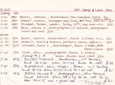
 Tarnagulla History Archive
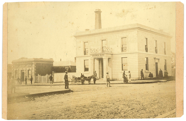
Photograph: Colonial Bank of Australasia (later Union Bank) in Tarnagulla, June 1866
David Gordon Collection. There were four banks in Tarnagulla at one stage, but two - the National Bank and the Bank of Australasia - were open for a short period only. The single-storey brick building at far left was built in 1859 and used by the Union Bank until 1888, and was later renamed 'Lochcarron' and used as premises by doctors and dentists. The two-storey building (right) was built in 1866 by the Colonial Bank of Australasia. Before this, the site had been occupied by Foo's shop. Whilst it was being built, the Colonial Bank operated from Company's Hotel (later known as Burstall Hall and the Council Chambers). The double-storey building in this image was used by the Colonial Bank from 1866 until 21st February, 1888. The premises were sold to the Union Bank for £2500. The Union Bank moved in and commenced operations on 6th June 1888, continuing until 1942. The building was later used as a general store until the 1990s. Both buildings are now private residences. This image was created by Aime Marchand in June 1866. Marchand (1846-1910) made a series of fourteen photographs which were submitted to the 1866-67 Melbourne Intercolonial Exhibition, where they earned a 1st Class Honourable Mention. This is one of those fourteen images. Of French or Belgian origin and possibly formerly an assayer in California, Marchand appears to have begun his practice of photography in Tarnagulla around 1865 as an assistant to A.B. Clay. By the following year he had settled in Portland, where he opened the Royal Photographic Studio in Gawler Street. From his base in Portland he toured surrounding districts, offering portrait and view services. Little else is known about his life. He appears to have left Australia in 1878. A misprint of his name in a local directory as Annie Marchand created the misconception that he was one of only a few named women photographers in the colonies. -
 The Beechworth Burke Museum Research Collection
Card (Series) - Index Card, George Tibbits, Camp Street, Beechworth, 1976
George Tibbits, University of Melbourne. Faculty of Architecture, Building and Town & Regional PlanningIndex system that support the research for Beechworth : historical reconstruction / [by] George Tibbits ... [et al]Arranged by street names of BeechworthEach index card includes: street name and number of property, image of property, allotment and section number, property owners and dates of ownership, description of the property according to rate records, property floor plan with dimensions.beechworth, george tibbitsbeechworth, george tibbits -
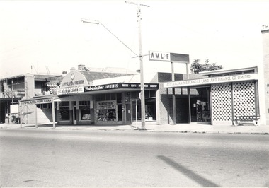 Wodonga & District Historical Society Inc
Photograph - Mann Collection Album - Terminus Hotel; Gippsland & Northern
This photo is part of a collection of Wodonga Town Photos donated by Elaine Mann. Elaine was married to David Mann, a successful Wodonga businessman and community leader who passed away in Wodonga in June 2012. David was a member of the Mann family who began their business in Wodonga in 1920. Elaine was a teacher in Wodonga for many years and an active member of the community. The Terminus Hotel In 1873, James Thompson Hatch built the two-storeyed Terminus Hotel at 79 Sydney Road (later known as High Street), then sold it to George Day and Kenneth McLennan for £1,230. It was first licensed to J. G. Morton in January 1874. In 1879, Annie Allen, from Ireland, took over as licensee of the hotel containing 14 rooms, after she and her husband, George James Allen, purchased it. He became licensee in 1883. Under the Allens, the Terminus became, ‘a principal rendezvous for visitors to the town.’ September 1888 saw additions to the building that included a billiard room, a dining room, and 18 other rooms. Following the death of her husband in 1889, Annie Allen continued to run the Terminus Hotel. She later married John Haldon and was licensee of the hotel until 1893 when the licence was transferred to William Carkeek. In the early 1900s the Hotel was thoroughly renovated. The Terminus Hotel was for sale by auction on 5th March 1909. It comprised about 50 rooms, a two-storey building built of brick and iron with hot and cold water service and acetylene gas throughout. The principal hotel in Wodonga, was let from 1st January 1909 on a seven years’ lease at a rental of £9 per week. 1935 saw extensive improvements by proprietor W. P. Kinney, while in 1941 further extensive improvements were carried out to make a good hotel better. A pall of shock and disbelief descended over Wodonga’s historic Terminus Hotel on 1st June 1998 when it was destroyed by fire then demolished in 1999. The site was sold for almost $1 million and redeveloped for a medical clinic.This photo collection is of significance as it documents how the businesses and buildings in Wodonga have evolved and contributed to community throughout the late 20th century.Terminus Hotel; Gippsland & Northern Co-operative Pty. Ltd.; Graham Bradbury Men's Hairdresser; Patricia Anne Fashions; Australian Mercantile Land and Finance Company (A.M.L. & F). on the west side of High Street. The Terminus Hotel was built C. 1873. and was destroyed by fire in 1998, The Gippsland and Northern Co-operative Co. Ltd was formed in 1905, but the date of its establishment in Wodonga is not confirmed, but they were holding fortnightly sales at the Wodonga sale yards by early 1919.wodonga businesses, high st wodonga, terminus hotel, gippsland & northern -
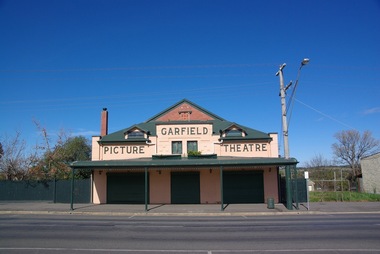 Ballarat Heritage Services
Photograph - Photograph - Colour, Clare Gervasoni, Garfield Picture Theatre, 2011, 27/08/2017
The Garfield Picture Theatre was built in 1924 for Martin Donohue, and according to Mr H. Arnold, who wrote a history of the theatre, it was leased to J. Taylor. It was said to have seated 800 people, and dances were held on Friday evenings with pictures shown on Saturday nights. The theatre was one of the many movie-viewing venues constructed during the Australia-wide boom in cinema building in the 1920s. The Garfield Picture Theatre was Cardinia Shire’s first cinema in the region, followed by Kooweerup’s Wattle Theatre and Pakenham’s King’s Picture Theatre which opened in mid to late 1927. The theatre is significant to the area as it’s one of the few picture theatre buildings remaining in the shire. The Garfield Picture Theatre was not only the main entertainment hub for the area, but it was the town’s first source of electricity. The theatre closed in 1962 and reopened in the 1980s as the Garfield Trading Centre, owned by Sam Jensen, who used to sell used furniture, bric-a-brac and antiques. The theatre stayed that way until 2001, when renovations began by owners Fred and Susan Perez. The theatre was in need of some serious repair and improvement. Fred and Susan spent 17 years relaying and polishing the original floorboards, installing roof insulation, as well as building a commercial kitchen, inside toilets with a disable toilet, upstairs living quarters, full verandah, and drainage and decking around the whole outer edge of the theatre. The theatre is a well-preserved and gabled red brick building, with internal renovations creating a grander experience than the original. The front facade still has its original raised cement letters `Garfield Picture Theatre' and sits above a deep cantilever street verandah which extends the front of the building. The Garfield Picture Theatre made a triumphant return as an entertainment venue on Sunday 03 July 2016, and now hosts various music events and is a great venue for weddings, corporate events and dances. The theatre seats 250 and has a lovely outside area with beautiful gardens including piano. Colour photographs of the Garfield Picture Theatre.garfield, garfield theatre -
 Bendigo Military Museum
Postcard - POSTCARD, FARNHAM, U.K, Valentine's Series, cWW1
1. Florrie is a relative living in Farnham. 2. R.H. Baron married Elsie Keast in 1921. All cards relate to R.H. Baron's visits to Farnham whilst on leave to see Florrie. Part of the 'Robert H. Baron', no.3596 and Cooper Collection. See Catalogue No. 1981P for details of Baron's service.1. Coloured scene of a ruined castle and surrounding gardens. 2. Coloured scene of a garden with building and ruins in background. 3. Coloured photograph of a red brick building with battlement. 4. Coloured street scene with buildings, horse drawn transport and pedestrians. 5. Coloured photograph of the nave of a church looking towards the alter. 6. Coloured street scene with buildings and horse drawn transport. 7. Coloured view across a street to a white walled building with horse drawn transport. 8. Coloured photograph of a church, graveyard in foreground. 9. Black and white photograph of a castle surrounded by trees. 10. Black and white photograph of a forest scene with people standing on a bridge. 11. Black and white photograph of a street scene with buildings, horse drawn transport and people. 12. Black and white photograph of the tower of a church. Graveyard in the foreground. 13. Black and white photograph of a street scene with buildings, horse drawn transport and pedestrians. Castle on the hill in background. 14. Black and white photograph of a street scene with buildings, motor cars and pedestrians. 15. Black and white photograph of a street scene with buildings, motor cars, horse drawn transport and pedestrians. 16. Black and white photograph of a wooded valley. Houses on a hill in the background. 17. Black and white photograph of an avenue of trees. 18. Black and white photograph taken in a park. Three people standing on a bridge over a stream.1. The Keep, Farnham Castle. Handwritten in black ink on back: 'This is one of the pretty places around Farnham. I was all once here with Florrie. Bob' 2. In Castle grounds, Farnham. Handwritten in black ink on back: 'Dear Elsie, these are some places that visit... when I was down at Flories place. Bob xxxxxx' 3. Farnham Castle. 4. West Street, Farnham. 5. Parish Church, Farnham. 6. Castle Street, Farnham. 7. The Church House, Farnham. 8. Parish Church, Farnham. 9. Farnham Castle. 10. Red Hill Hanger, Farnham. Handwritten in black ink on back: 'Letter to R.H. Baron's sister - no date.' 11. South Street, Farnham. Handwritten in black ink on back: 'this part of the place I spent my leave at this is where Florrie is.' 12. Farnham Parish Church. Handwritten in black ink on back: 'Letter to R.H. Baron's mother - dated 24 July 1918.' 13. Castle Street, Farnham. Handwritten in black ink on back. 'I think you will know where this is as I have told you quite a lot about Farnham, it is where Florrie is. I spent my leave here. This is Castle Street and the castle is right on the top of the hill.' 14. Borough, Farnham. Handwritten in black ink on back. ' This is the place where Florrie lives. I spent my last leave their (sic), Bob.' 15. West Street, Farnham. Handwritten in pencil on back. 'Pte R.H. Baron, 57 Battalion, Australian Imperial Forces Abroad.' 16. Lower Bourne Valley, Farnham. Handwritten in black ink on back: 'Partial letter from R.H. Baron to his sweetheart.' 17. The Avenue, Farnham. Handwritten in black ink on back: 'Partial letter from R.H. Baron to his mother.' 18. Recreation Ground, Farnham. Handwritten in black ink on back: 'Letter to Doris from R.H. Baron - no date.' robert h. baron, cooper collection, postcards, farnham uk -
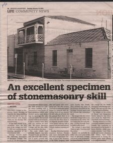 Bendigo Historical Society Inc.
Document - BARBARA MAMOUNEY COLLECTION: NEWSPAPER ARTICLE ON SPECIMEN COTTAGE
Newspaper feature from Bendigo Advertiser Tues January 12 2016 and image of Specimen Cottage before restoration in 1970s It was built by stonemason James Brierley for his family Is now the front of house and display centre for The Bendigo Historical Society and is arguably the oldest building in the city with 1856 shown above the front door Near the corner of Hargreaves and Mundy St The building has two parts The 1856 section is single storey with front façade of locally sourced sandstone rubble with dressed quoins and dressings to openings, side walls are of rubble the rear and interior walls are of red brick a central front door a window on either side The roof which was probably hipped, was later joined to the next wall of the 1861 section and is partly covered with Morewood and Rogers metal tiles with partly corrugated iron The 1861 section was built to match the earlier one Across the first floor of the 1861 section is an elegantly detailed cantilevered timber balcony with a hived concave roof and two French windows opening onto it Bendigo Historical Society members Barbara Poustie and Carol Holsworth have led tours of the cottage as part of the 'Summer in the parks' program A plaque on the corner of Hargreaves and Mundy indicates that there once stood the Royal Princess Hotel, also built by Brierley, Bendigo Historical Society members have continued research on the Brierley familyhistory, australian, bendigo, architecture, specimen cottage royal princess hotel built by james brierly in 1856 barbara proustie carol holsworth -
 Bendigo Historical Society Inc.
Newspaper - BARBARA MAMOUNEY COLLECTION: 3 NEWSPAPER ITEMS,ONE INCLUDING AN IMAGE OF 3 PEOPLE
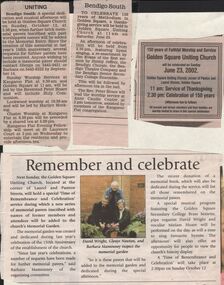
4 Newspaper items, one headed 'Bendigo South' To Celebrate 150 years of Methodism in Golden Square held at Golden Square Uniting Church at 11am on Saturday June 23; re-enactment by Jim Evans of the first sermon by Jimmy Jeffrey, the Bendigo Chorale , the Bendigo Theatre Company, Bendigo Senior Secondary College Ensemble. Followed by an afternoon tea in the hall. The Reverend Peter Hoare will lead the worship service at Anne Caudle Centre at 2pm tomorrow assisted by members of the Kangaroo Flat congregation; another headed 'Uniting' a special dedication and musical afternoon will be held at Golden Square Church on Sunday October 12 at 2.30pm when further brick pavers inscribed with past worshippers names will be added to the Memorial Entry. Since the creation of this memorial at last years 150th anniversary several requests have been received for further pavers to be. Anyone wishing to include a memorial paver should contact Glenys on 5443 9451 or Barbara on 5443 6323. Sunday Worship at Kangaroo Flat at 9.30am Golden Square at 11am will be led by the Reverend Peter Hoare and will include Holy Communion. Lockwood worship at 10.30 am and will be led by Marilyn Hocking. Cluster Worship at Kangaroo Flat at 6.30 pm will be preceded by a shared tea at 5.30 pm. Kangaroo Flat Evening Fellowship will meet at St Laurence Court at 2 pm on Wednesday to entertain the residents and provide afternoon tea.celebration of 150 years of methodism in golden square; golden square uniting church, laurel & panton sts; david wright, glenys newton and barbara mamouney; jim evans; jimmy jeffrey; bendigo chorale; bendigo theatre company; and bendigo senior secondary college; reverend peter hoare anne caudle centre; kangaroo flat congregation; glenys 5443 9541; barbara 5443 -
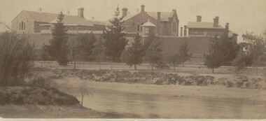 Bendigo Historical Society Inc.
Photograph - BENDIGO GAOL, FROM COMMISSIONER'S GULLY, c.1880
Sepia photograph of the Bendigo Gaol looking across from Barnard Street, Mining dam in foreground. . Conifers along Northern bank of creek with gaol buildings in the background. All buildings are of masonry. Inscriptions: '37' in red ballpoint ink top RH corner. On back of mount: stamped in circle 'Royal Historical Society of Victoria, Bendigo Branch' In blue ballpoint ink above circly '1959' In red ballpoint ink above circle '37'. In blue ballpoint ink in one corner '1880'. Inclusions in storage envelope: Bendigo Gaol, J Lerk, 28/02/2000. The Bendigo Gaol looking across Commissioner's Gully c1880. The grey granite cell blocks contrast with the red brick exterior walls. Photograph courtesy Bendigo Historical Sociery (No. 136, texta on back). Machine printed inclusion worded as above entry. Another inclusion written in pencil states ' Bendigo Gaol about 1880. Granite from Big Hill was used to construct the cell blocks about 1860. Prisioners did not have heating, beds, seats or eating utensils. A public meeting in 1862 called for the debtor's quarters at the gaol to be lit with gas, handsomely furnished throughout and that inmates be provided with a bottle of wine, one bottle of brandy daily and tobacco and pipes availabe at liberty. (from Butcher, 'Annals of Bendigo 1862, Vol. 1, 76B).buildings, government, watch house, sandhurst -
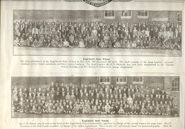 Bendigo Historical Society Inc.
Photograph - EAGLEHAWK STATE SCHOOL 1925, 1928
Two black and white photographs mounted on a board. Top photo - large group of girls with teachers. Bottom photo - large group of boys with teachers. Both photographed outside brick building with three windows and timber addition at R with one window. These photos appear to be cut from the 'Back to Eaglehawk, October 199298 Souvenir booklet'. Inscriptions: on front - printed in red ink 'Eaglehawk State School 1928'. Rubber stamp 'HJG Biggs, Health Inspector'. Printed at CT 'Oct 1928, Back to Eaglehawk'. Printed under top photo 'Eaglehawk State School. The total attendance at the Eaglehawk State is 37-, with 180 boys and 190 girls. The staff consists of the head teacher, one male assistant, seven female assistants, and three junior teachers. The head teacher, Mr GP Hibberd, has just been transferred to the Central School Bendigo, and Mr Charles F Tilson is in charge temporarily'. Printed under bottom photo 'Eaglehawk State School. Mr CF Tilson, who is now at the head of the Eaglehawk School temporarily, has been in charge of the central classes for some time. Miss E Trewavis is the first female assistant, in charge of the infant department. There is also an 'opportunity class for backward pupils. Miss M Esposito in charge'. History: Previous Acc. No. MP 108.person, group, eaglehawk state school -
 Bendigo Historical Society Inc.
Photograph - HILDA HILL COLLECTION: BLACK AND WHITE PHOTOS, 1917-1923
Series of Black & White Photos Total of 10 two severely damaged detailing the life of the Hill family and friends during the war and post World War One.Frank and Dev photo severely damaged. Vin astride an old Indian motorcycle Reg no. 24797, street setting showing gutter dilapidated paling fence further background shows large building with spire. Mollie and Hilda wooden framework of a gateway, severely damaged. Darkie the horse in forested situation 'The Pines' January 1919. Doreen sitting on the backrest of a long seat wearing a dark coloured dress with white collar trees and shrubbery in background. Dora wearing a dark dress with white collar standing in a garden situation , lawn and hedge in background, 'The lawns' 1917. Royston standing in school uniform of dark suit white shirt and dark tie, two younger boys (unnamed) kneeling on the ground both wearing grey suits white shirts and dark ties, all amid long grass, white picket fence and hedge with trees in the background. 'Jock' small terrier or foxy standing on a white chair in front of a palm tree, distant background shows sections of a picket fence. Miss Tovey dressed in white next to a brick wall, to her left fence with hedge at 'The Ranche' 1918.Hal attired in warm dark clothing and wearing a white beanie at Mt Buffalo July 1923.Hilda Hill Personal Collectionaustralia, history, post war life -
 Kew Historical Society Inc
Plan, Melbourne & Metropolitan Board of Works : Borough of Kew : Detail Plan No.1576, 1904
The Melbourne and Metropolitan Board of Works (MMBW) plans were produced from the 1890s to the 1950s. They were crucial to the design and development of Melbourne's sewerage and drainage system. The plans, at a scale of 40 feet to 1 inch (1:480), provide a detailed historical record of Melbourne streetscapes and environmental features. Each plan covers one or two street blocks (roughly six streets), showing details of buildings, including garden layouts and ownership boundaries, and features such as laneways, drains, bridges, parks, municipal boundaries and other prominent landmarks as they existed at the time each plan was produced. (Source: State Library of Victoria)This plan forms part of a large group of MMBW plans and maps that was donated to the Society by the Mr Poulter, City Engineer of the City of Kew in 1989. Within this collection, thirty-five hand-coloured plans, backed with linen, are of statewide significance as they include annotations that provide details of construction materials used in buildings in the first decade of the 20th century as well as additional information about land ownership and usage. The copies in the Public Record Office Victoria and the State Library of Victoria are monochrome versions which do not denote building materials so that the maps in this collection are invaluable and unique tools for researchers and heritage consultants. A number of the plans are not held in the collection of the State Library of Victoria so they have the additional attribute of rarity.Original survey plan, issued by the MMBW to a contractor with responsibility for constructing sewers in the area identified on the plan within the Borough of Kew. The plan was at some stage hand-coloured, possibly by the contractor, but more likely by officers working in the Engineering Department of the Borough and later Town, then City of Kew. The hand-coloured sections of buildings on the plan were used to denote masonry or brick constructions (pink), weatherboard constructions (yellow), and public buildings (grey). Development in the 20th century has irreparably altered that part of Kew represented in this plan. In the block bounded by Cotham Road, Charles Street, Wellington Street and Gellibrand; just one house standing in 1903 remains. This block included two of the most historic houses in Kew: ‘Ordsall’ (later ‘Southesk’) and ‘Madford’ (previously ‘Elm Lodge’). Ordsall was the home of the second chairman of Kew, John Halfey. It contained some of the most significant interior murals in Kew, created for Halfey by artists working for Cullen & Co. It was demolished in 1960 to make way for the Kew Civic Centre. Elm Lodge had been built for William Siddeley in ca. 1864. Arthur Septimus King purchased it in 1874. The lower paddocks of Madford were sold in 1905 by his wife to the Borough of Kew and, after landscaping by George and Thomas Pockett, opened as the Alexandra Gardens in 1908. Elm Lodge/Madford was in 1922 to become St. Anthony’s Home for Little Children before its subsequent demolition in the 1980s.melbourne and metropolitan board of works, detail plans, maps - borough of kew, mmbw 1576, cartography -
 Kew Historical Society Inc
Plan, Melbourne & Metropolitan Board of Works : Borough of Kew : Detail Plan No.1581, 1904
The Melbourne and Metropolitan Board of Works (MMBW) plans were produced from the 1890s to the 1950s. They were crucial to the design and development of Melbourne's sewerage and drainage system. The plans, at a scale of 40 feet to 1 inch (1:480), provide a detailed historical record of Melbourne streetscapes and environmental features. Each plan covers one or two street blocks (roughly six streets), showing details of buildings, including garden layouts and ownership boundaries, and features such as laneways, drains, bridges, parks, municipal boundaries and other prominent landmarks as they existed at the time each plan was produced. (Source: State Library of Victoria)This plan forms part of a large group of MMBW plans and maps that was donated to the Society by the Mr Poulter, City Engineer of the City of Kew in 1989. Within this collection, thirty-five hand-coloured plans, backed with linen, are of statewide significance as they include annotations that provide details of construction materials used in buildings in the first decade of the 20th century as well as additional information about land ownership and usage. The copies in the Public Record Office Victoria and the State Library of Victoria are monochrome versions which do not denote building materials so that the maps in this collection are invaluable and unique tools for researchers and heritage consultants. A number of the plans are not held in the collection of the State Library of Victoria so they have the additional attribute of rarity.Original survey plan, issued by the MMBW to a contractor with responsibility for constructing sewers in the area identified on the plan within the Borough of Kew. The plan was at some stage hand-coloured, possibly by the contractor, but more likely by officers working in the Engineering Department of the Borough and later Town, then City of Kew. The hand-coloured sections of buildings on the plan were used to denote masonry or brick constructions (pink), weatherboard constructions (yellow), and public buildings (grey). The streets and built structures in this plan were surveyed in 1903 and released to contractors in 1904. In addition to the designation of building types by colour, the plan includes detailed descriptions of land use and ownership. While many buildings remain from this period, a number of the buildings represented have been demolished including the original Kew Town Hall, and the Congregational and Roman Catholic churches in Walpole Street. While the mansion ‘Illapa’ in Princess Street is still extant – now part of ‘Rylands’ – the neighbouring mansion ‘Elsmere’ was demolished some decades ago. Rivalling Illapa and Elsmere in size were two mansions in Walpole Street, one named on the plan as ‘Gnarlbine’. Over time, Kew Junction and the south side of High Street have been reconfigured and widened, so that the commercial buildings on the corner of Princess and High Street no longer exist. A surprising feature of this part of central Kew to the northwest of Kew Junction is the amount of vacant land. In a number of cases, this land is noted by the contractor as used for vegetable gardens.melbourne and metropolitan board of works, detail plans, maps - borough of kew, mmbw 1581, cartography -
 Kew Historical Society Inc
Plan, Melbourne and Metropolitan Board of Works, Melbourne & Metropolitan Board of Works : Borough of Kew : Detail Plan No.1294 & 1295, 1904
The Melbourne and Metropolitan Board of Works (MMBW) plans were produced from the 1890s to the 1950s. They were crucial to the design and development of Melbourne's sewerage and drainage system. The plans, at a scale of 40 feet to 1 inch (1:480), provide a detailed historical record of Melbourne streetscapes and environmental features. Each plan covers one or two street blocks (roughly six streets), showing details of buildings, including garden layouts and ownership boundaries, and features such as laneways, drains, bridges, parks, municipal boundaries and other prominent landmarks as they existed at the time each plan was produced. (Source: State Library of Victoria). This plan forms part of a large group of MMBW plans and maps that was donated to the Society by the Mr Poulter, City Engineer of the City of Kew in 1989. Within this collection, thirty-five hand-coloured plans, backed with linen, are of statewide significance as they include annotations that provide details of construction materials used in buildings in the first decade of the 20th century as well as additional information about land ownership and usage. The copies in the Public Record Office Victoria and the State Library of Victoria are monochrome versions which do not denote building materials so that the maps in this collection are invaluable and unique tools for researchers and heritage consultants. A number of the plans are not held in the collection of the State Library of Victoria so they have the additional attribute of rarity.Original survey plan, issued by the MMBW to a contractor with responsibility for constructing sewers in the area identified on the plan within the Borough of Kew. The plan was at some stage hand-coloured, possibly by the contractor, but more likely by officers working in the Engineering Department of the Borough and later Town, then City of Kew. The hand-coloured sections of buildings on the plan were used to denote masonry or brick constructions (pink), weatherboard constructions (yellow), and public buildings (grey).The streets and built structures in MMBW Detail Plan 1294 & 1295 were surveyed in 1903 and released to contractors in 1904. This plan is one of two in the collection where the lithographers amalgamated two separate plans. Both plans include sections of Studley Park. Dominating the south and west corners of Kew Junction are the Clifton and Kew Hotels. The Kew Hotel, owned by Patrick O’Shaughnessy was one of the oldest in Kew. MMBW plans were amended over time to take account of new subdivisions such as that which created Merrion Place. Of the four mansions shown in Studley Park Road, three remain – ‘Field Place’, the home of Frances Henty, ‘Leaghur’ and ‘Darley’. ‘Byram’ (later ‘Goathland’, then ‘Tara Hall’) was an architectural marvel. Designed in 1888 by E.G. Kilburn for the paper magnate George Ramsden, it was demolished in 1960. While an earlier sale of the southern section of Byram had created Tara Avenue in 1927, the demolition of the house in 1960 enabled the extension of Tara Avenue northward.melbourne and metropolitan board of works, detail plans, mmbw 1294, mmbw 1295, cartography -
 Kew Historical Society Inc
Plan, Melbourne & Metropolitan Board of Works : Borough of Kew : Detail Plan No.1297, 1904
The Melbourne and Metropolitan Board of Works (MMBW) plans were produced from the 1890s to the 1950s. They were crucial to the design and development of Melbourne's sewerage and drainage system. The plans, at a scale of 40 feet to 1 inch (1:480), provide a detailed historical record of Melbourne streetscapes and environmental features. Each plan covers one or two street blocks (roughly six streets), showing details of buildings, including garden layouts and ownership boundaries, and features such as laneways, drains, bridges, parks, municipal boundaries and other prominent landmarks as they existed at the time each plan was produced. (Source: State Library of Victoria)This plan forms part of a large group of MMBW plans and maps that was donated to the Society by the Mr Poulter, City Engineer of the City of Kew in 1989. Within this collection, thirty-five hand-coloured plans, backed with linen, are of statewide significance as they include annotations that provide details of construction materials used in buildings in the first decade of the 20th century as well as additional information about land ownership and usage. The copies in the Public Record Office Victoria and the State Library of Victoria are monochrome versions which do not denote building materials so that the maps in this collection are invaluable and unique tools for researchers and heritage consultants. A number of the plans are not held in the collection of the State Library of Victoria so they have the additional attribute of rarity.Original survey plan, issued by the MMBW to a sewage contractor with responsibility for constructing sewers in the area identified on the plan within the Borough of Kew. The plan was at some stage hand-coloured, possibly by the contractor, but more likely by officers working in the Engineering Department of the Borough and later Town, then City of Kew. The hand-coloured sections of buildings on the plan were used to denote masonry or brick constructions (pink), weatherboard constructions (yellow), and public buildings (grey). This plan of Kew encompasses the area bounded by Barkers Road, High Street and Stevenson Street. Because of the angle created by High Street, a number of houses on the northern side of High Street are shown. The area is dominated by one of the great original landholdings in Kew, described here as the ‘Findon Paddock’. ‘Findon’, the house from which the name of the paddock was taken fronts Stevenson Street and was clearly a rambling structure. The best-known occupant of Findon was Henry ‘Money Miller’ who bought the house in 1871. Miller was a member of Victoria’s first parliament and assisted in the framing of its constitution. Findon was to be subdivided as early as 1912, when the Findon Subdivision was advertised to be sold by auction. In the plan of the subdivision, the original house is not shown, so, presumably it had previously been demolished. Fincham & Son moved the organ, built by Henry Willis, which was installed in the house, first to ‘Whernside’ in Toorak, and later to the Box Hill Methodist Church.melbourne and metropolitan board of works, detail plans, mmbw 1297, cartography, kew (vic.) — municipal collection -
 Kew Historical Society Inc
Plan, Melbourne & Metropolitan Board of Works : Borough of Kew : Detail Plan No.1571, 1904
The Melbourne and Metropolitan Board of Works (MMBW) plans were produced from the 1890s to the 1950s. They were crucial to the design and development of Melbourne's sewerage and drainage system. The plans, at a scale of 40 feet to 1 inch (1:480), provide a detailed historical record of Melbourne streetscapes and environmental features. Each plan covers one or two street blocks (roughly six streets), showing details of buildings, including garden layouts and ownership boundaries, and features such as laneways, drains, bridges, parks, municipal boundaries and other prominent landmarks as they existed at the time each plan was produced. (Source: State Library of Victoria)This plan forms part of a large group of MMBW plans and maps that was donated to the Society by the Mr Poulter, City Engineer of the City of Kew in 1989. Within this collection, thirty-five hand-coloured plans, backed with linen, are of statewide significance as they include annotations that provide details of construction materials used in buildings in the first decade of the 20th century as well as additional information about land ownership and usage. The copies in the Public Record Office Victoria and the State Library of Victoria are monochrome versions which do not denote building materials so that the maps in this collection are invaluable and unique tools for researchers and heritage consultants. A number of the plans are not held in the collection of the State Library of Victoria so they have the additional attribute of rarity.Digital copy of the original survey plan, issued by the MMBW to a contractor with responsibility for constructing sewers in the area identified on the plan within the Borough of Kew. The plan was at some stage hand-coloured, possibly by the contractor, but more likely by officers working in the Engineering Department of the Borough and later Town, then City of Kew. The hand-coloured sections of buildings on the plan were used to denote masonry or brick constructions (pink), weatherboard constructions (yellow), and public buildings (grey). This plan is part of a large and historically significant group of MMBW plans and maps that was donated to the Society by the Mr Poulter, City Engineer of the City of Kew in 1989. When the contracts were let for surveyors to identify and record the extant houses and landscapes within an area for the Board of Works, the contracts were let at separate times, hence the anomaly where two copies of Plan No.1571 exist in our collection. The first of these plans identifies the building materials used in houses bordering Fitzwilliam Street, Edgevale Road, May Street, Malin Street, Davis Street and Wellington Street. The cut off point for the survey was the south side of Wellington Street. By 1903 when the survey was undertaken many of the sites were already built on, particularly those facing Edgevale Road. The plan identifies the preponderance of weatherboard houses in the area. The other version of the plan identifies the buildings between Wellington Street and Cotham Road.melbourne and metropolitan board of works, detail plans, mmbw 1571, cartography