Showing 123968 items matching "main-road"
-
 Stawell Historical Society Inc
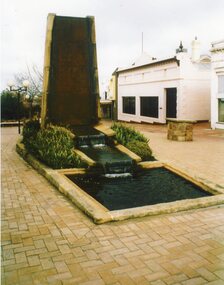
Photograph, Athletic Club Memorial Fountain in the Gold Reef Mall in Upper Main Street Stawell built of Grampians Freestone -- Coloured
Colour photo of Athletic Club Memorial Fountain - Gold Reef Mall Main Street Stawell built of Grampians Freestonestawell -
 Stawell Historical Society Inc
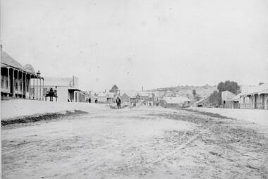
Photograph, Patrick Street Stawell looking towards Main Street Stawell showing the Victoria Bakery of Mr J Walker c1880
Streetscape Patrick Street Stawell looking towards Main Street. Stawell. Showing Victoria Bakery J. Walker c1880stawell business, streetscape -
 Stawell Historical Society Inc
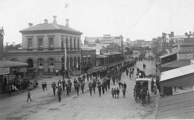
Photograph, Main Street Stawell -- Procession passing the Post Office with a band and soldiers marching c1914-1918
Main Street Procession passing Post Office Circa 1914-18. Band and soldiers marching. World War 1stawell ww1 streetscape -
 Stawell Historical Society Inc
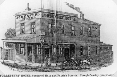
Drawing, Mr J Crawley Foresters’ Hotel at the corner of Main Street Stawell & Patrick Street from the P.C. News Supplement 1888 -- Sketch
Foresters’ Hotel J. Cawley corner 186 Main Street and Patrick Street from P.C. News Supplement 1888stawell businesses -
 Stawell Historical Society Inc
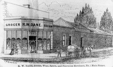
Drawing, Mr R. W. Dane Grocer & Baker on the corner Main Street Stawell & Layzell Street from the P.C. News Supplement 1888-- Sketch
R. W. Dane Grocer & Baker corner Main Street and Layzell Street from P.C. News Supplement 1888stawell businesses -
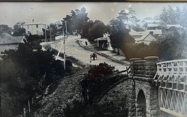 Greensborough Historical Society
Photograph - Photograph (Framed), Blue stone bridge looking up Main Street Greensborough
Blue stone bridge looking up Main Street Greensborough. Bridge lower right and Marble Hall upper left.From the John Mackey collection. this item was displayed at the offices of Ryan, Mackey and Kelly, solicitors, Main Street Greensborough.Timber-framed photograph of view of Greensborough, black and white.greensborough, john mackey, blue stone bridge, marble hall -
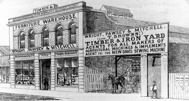 Stawell Historical Society Inc
Drawing, Wright, Pawsey & Mitchell in Main Street Stawell from the P.C. News Supplement 1888 -- Sketch
Wright. Pawsey & Mitchell Main Street Stawell from P.C. News Supplement 1888 Later years occupied by Coles.stawell businesses -
 Stawell Historical Society Inc
Drawing, Mr W. Whiteside & Co., Tailors in Main Street Stawell from the P.C. News Supplement 1888 -- Sketch
W. Whiteside & Co. Tailors Main Street beside Town Hatt Hotel from P.C. News Supplement 1888Line Drawing of three fronted shop with four bay verandah. Four wheel, two horse buggy in front and number of people on verandah. stawell businesses -
Stawell Historical Society Inc
Photograph, Telford Family Photograph Album including the Telford family business of Hay Provisions and General Grocer in Main Street Stawell
Telford Family Photograph Album. Telford family had business Hay Provisions and General Grocer main Street Stawellstawell -
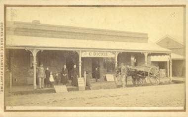 Bacchus Marsh & District Historical Society
Photograph, George Dickie Bakery Main Street Bacchus Marsh 1883
George Dickie arrived in the Bacchus Marsh area around 1857. In 1863, he married Ellen Ross Anderson, and after five years of farming in Coimadai, they moved into Bacchus Marsh and established a business. In 1866 he bought the bakery business which had been established by James Boatwood and later conducted by William Watson. This business was in Main Street and is shown in this image during the time it was owned and operated by George Dickie. Ellen and George Dickie had seven children, two sons and five daughters. In his later years he changed the business into a general store and also engaged in grain dealing. He died in 1904 but the business was carried on by his sons until sold in March 1916 to a Charles Medling from Numurkah. The building was later demolished in 1927 to make way for four new shops.Small sepia 'carte de viste' style unframed photograph on card with gold border framing photograph. Housed in the Jeremeas Family Album which contains photographs of Bacchus Marsh and District in 1883 by the photographers Stevenson and McNicoll. The picture shows the business of George Dickie which was located in Main Street Bacchus Marsh. The building is a brick or stone structure with a verandah along the entire frontage of the building. Standing in front of the building is a group of adults and children. On the far left is a man wearing a dress coat and hat. He is possibly Mr. George Dickie the owner of this business. To his left are some younger and older children, and a woman, possibly Mrs DIckie. In the background in the doorway is a young boy with woman behind him. On the right of the picture on the street is a man standing alongside a horse and cart. Some advertising signs are leaning against the shop, footpath and verandah pillar. One of them says 'Chaff, Oats, Bran'. Printed On the front: Stevenson & McNicoll. Photo. 108 Elizabeth St. Melbourne. COPIES CAN BE OBTAINED AT ANY TIME. On the back: LIGHT & TRUTH inscribed on a banner surmounted by a representation of the rising sun. Copies of this Portrait can be had at any time by sending the Name and Post Office Money Order or Stamps for the amount of order to STEVENSON & McNICOLL LATE BENSON & STEVENSON, Photographers. 108 Elizabeth Street, MELBOURNE. stevenson and mcnicoll 1883 photographs of bacchus marsh and district, bakeries, shops bacchus marsh, george dickie 1831-1904, dickie family bacchus marsh -
 Whitehorse Historical Society Inc.
Photograph, Blackburn Road, 1983
Laser Print of black and white photo of Blackburn Road near Allendale Road, Blackburn. (Mounted)blackburn road, blackburn, alandale road, blackburn -
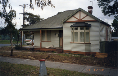 Whitehorse Historical Society Inc.
Photograph, Whitehorse Road Mitcham No.427, 21/12/2001 12:00:00 AM
Coloured photograph of 427 Whitehorse Road, Mitcham on the corner of Dunlavin Road. In process of being renovatedwhitehorse road, mitcham, no. 427 -
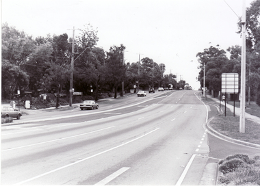 Whitehorse Historical Society Inc.
Photograph, Canterbury Road, Blackburn, 6/01/2001 12:00:00 AM
Black and white photograph of Canterbury Road, Blackburn looking west from corner of Blackburn Road.canterbury road, blackburn., blackburn road -
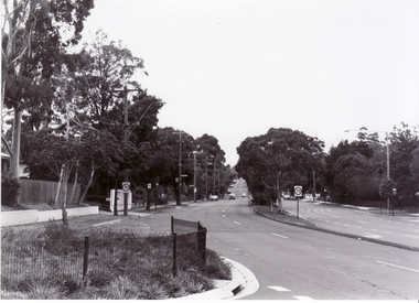 Whitehorse Historical Society Inc.
Photograph, Blackburn Road, Blackburn, 6/01/2001 12:00:00 AM
Black and white photograph of Blackburn Road, Blackburn South looking south from Canterbury Road.blackburn road, blackburn south, canterbury road -
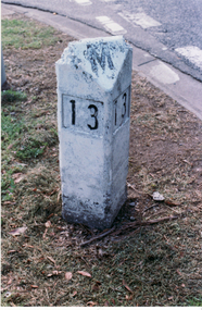
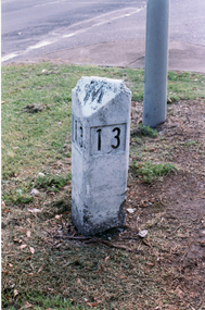 Whitehorse Historical Society Inc.
Photograph, Road Marker
Coloured photo of Road Marker on Median Strip, corner Whitehorse Road and Peel Street, Mitcham.whitehorse road, mitcham, peel street, road markers -
 Whitehorse Historical Society Inc.
Photograph, Road Marker
Coloured photo of Road Marker on Median Strip, corner Whitehorse Road and Peel Street, Mitcham.whitehorse road, mitcham, peel street, road markers -
Surrey Hills Historical Society Collection
Document - Contract of sale, Contract of sale for 33 Kingston Road, Surrey Hills
No 33 Kingston Road is a red brick attic-style house which was built c1920. Edward Edwards (1880-1963) was a blacksmith and the first owner. The house was named 'Berwyn' (Ref: 1931 electoral roll). Edward's wife was Mary Kennedy Stewart (1873-1931). They had 7 children, all born before the family came to Surrey Hills: 1. Hazel Margaret Kennedy Edwards (1896-1966) - dressmaker in 1931 electoral roll 2. Edward Alexander Edwards (1898-1988) 3. Mary Gwendolyn Edwards(1899-1942) 4. Gladys Annie Edwards (1902-1988) - hairdresser in 1931 electoral roll 5. Clarence Edwards (1906-1988) - plumber in 1931 electoral roll 6. Alan Stewart Edwards (1909 - 1996) 7. Geoffrey Ellis Edwards (1910-1985). The property passed to Edward Henderson Redpath after Edward Edward's death. He was a mechanic. (Ref: 1963 electoral roll). He was born in Shilbottle England on 3 December 1904 and married Gladys Annie Edwards in 1932 (#8417). He served in the Australian Airforce during WW2. Thus, the property was owned by the same family for over 40 years. Edward Henderson Redpath sold the property to David Murray Flynn and Heather Rosemary Flynn of 18 Kingston Road, Surrey Hills in 1965. Associated records: 1. Letter from George Henderson P/L to T Redpath, 1965 2. Letter re estate of E H Redpath, 1969. A standard folded real estate contract of sale for 33 Kingston Road, Surrey Hills, dated 14 August 1965edward edwards, berwyn, 33 kingston road, mary stewart kennedy, mary stewart edwards, houses, real estate contracts, legal documents, hazel margaret kennedy edwards, edward alexander edwards, mary gwendolyn edwards, gladys annie edwards, clarence edwards, alan stewart edwards, geoffrey ellis edwards, edward henderson redpath, gladys annie redpath, david murray flynn, heather rosemary flynn, house names -
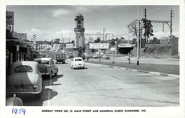 Ringwood and District Historical Society
Photograph/Postcard, Postcard - Murray Views No.12. Main Street and Memorial Clock, Ringwood, Vic
Black and white "Murray Views" postcard - Maroondah Highway looking east towards Memorial Clock Tower on Warrandyte Road intersection; railway bridge on right. Circa 1959."1959" handwritten on front. -
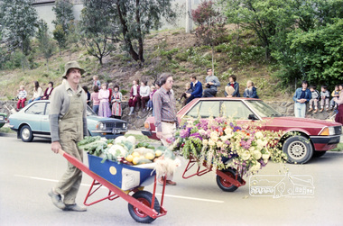 Eltham District Historical Society Inc
Photograph, Eltham Festival Parade, 16 October 1982, 1982
Roll of negatives of the Eltham Festival Parade as it progresses along Main Road past the Catholic Church heading towards Bridge Street. Floats included the Tasmanian Wilderness Society with the Save the Franklin River campaign, and Diamond Valley Railway celebrating 21 years of passenger service as well as the Victorian Police Marching Band. A well known Eltham identity, Jock Read was asked to lead the Eltham Pony Club contingent that year and the roll includes several shots of Jock on his horse, Lofty who was approximately ten years of age, his colour was still classed as a steel grey at the time before he went "white" quite a few years later. 1982: 16-17 October. “Pioneers of Eltham” and tractor (rain) Neswletter No. 27, November 1982 Although our parade entry did not win a prize this year, it was considered highly successful from a participation point of view. Despite some uncertainty as to just who was coming, members and friends kept appearing at the assembly area. As in the past years our friends from the Victorian Folk Music Club brought their instruments along and really added to the occasion. This year we concentrated on a rural theme with a tractor/trailer combination. Thanks to Peter Bassett-Smith for the tractor, Joh Ebeli for the decorations and friendly trailer owner Dennis McKay. Unfortunately the closing stages of the parade were marred by heavy rain. We just finished as the rain started but members scattered very quickly. This has prompted the suggestion for future parades that we have a tent or other suitable venue for members to gather after the event. This is worth following up. The cold driving rain provided a special problem for Peter in driving his tractor home to Kangaroo Ground. Have you ever had to choose between standing up to warm your hands on the exhaust and having your tractor seat flooded? Certificate, Festival Parade Award, Rotary Club of Eltham, Eighth Eltham Community Festival 1982. Presented to the Shire of Eltham Historical Society for the most effort by "locals"Roll of 35mm colour negative film, 24 shotsKodak Safety Film 5035eltham festival, catholic church, diamond valley railway, eltham, eltham district historical society, eltham parade, festivals, eltham fire brigade, eltham horse and pony club, jock read, learning co-op primary school, eltham living and learning centre, lofty (horse), main road, marching band, montmorency scouts, parade, parade floats, peter bassett-smith, research pre-school, roller city, shire of eltham historical society, victorian police -
 Ringwood and District Historical Society
Photograph, Maroondah Highway, Ringwood. Looking west from Warrandyte Road - 1965
Black and white photograph (2 copies)Typed under photograph: "Main Street, looking west from Warrandyte Rd. 1965". -
 Stawell Historical Society Inc
Photograph, Upper Main Street Reefs looking East towards Big Hill from the front of Joyce's Hibernian Hotel 1866
Upper Main Street Reefs looking East towards Big Hill taken from front of Joyce's Hibernian Hotel . Part of a collection of Photographs by Mr. O.G. Armstrong as commissioned by the Shire of Stawell for the Inter-colonial and Paris Exhibition in Melbourne in 1866. This scene was taken in 1866 in Main Street from in front of Joyce’s Iberian Hotel on the left, the site of the present townhall. It is looking uphill and eastward with Big Hill in the far background. The Hibernian Hotel was built on Commercial Street Pleasant Creek Goldfields in 1858 and was moved to Main Street Reefs, the present site of the Town Hall by Mr. & Mrs. Joyce. It was later destroyed by fire and the Town Hall built on its location. Street scene with buildings in distance and Big Hill in far distance.stawell streetscape -
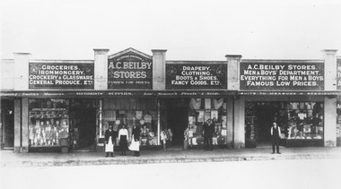 Ringwood and District Historical Society
Photograph, Maroondah Highway Central, Ringwood. Beilby Stores - Main Street, Ringwood (Opposite Railway Station),1924
Black and white photograph Printed below photograph: "A.C. Beilby. General Stores. Ringwood. Telephone 4", and "Beilby Stores, Main St. (Opposite Railway Station) 1924". Image shows a group of shops with 'A.C. Beilby Stores' written above veranda. -
 Greensborough Historical Society
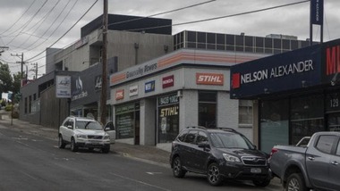
Photograph - Digital Image, Sandy Anton, Lower Main Street, March 2019, 2019_03
Photograph of lower Main Street area, taken in March 2019. Shows the Greensborough RSL, Green Valley Mowers and Nelson Alexander. Digital copy of colour photographmain street greensborough, greensborough rsl -
Greensborough Historical Society
Memoir, O'Neill's Greengrocers Main Street Greensborough / Nancy Fowkes (nee O'Neill), 1953-1969
Nancy Fowkes (nee O'Neill) tells the story of her father's greengrocers shop in Main Street Greensborough from 1953 to 1969.A personal story of life in Greensborough.One page of text.bill oneill, oneill family, nancy fowkes, main street greensborough -
 Lake Bolac & District Historical Society
Black and white photograph, Wickliffe, main street, circa 1920
Wickliffe, main street, taken from pine tree opposite the hotel. Presbyterian Church on the hill centre-left. 1920's.wickliffe, main street. -
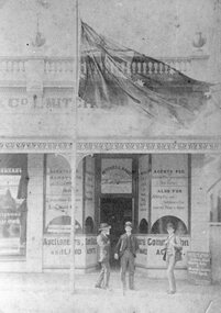 Stawell Historical Society Inc
Photograph, Mitchell Bros as Auctioneers of Stock and Land Agents in Main Street Stawell 1890
Business - Mitchell Bros. (Auctioneers Stock and Land Agents 1890) Main Street Stawell opposite Coles/Lyal Eales Store.stawell -
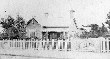 Stawell Historical Society Inc
Photograph, Mr Joseph Shilton's home in Main Steet Stawell 1870
Home of Joseph Shilton 1870 – Later ( Holy Trinity Vicarage Stawell 1922/23). Main Street Stawell Now demolished.stawell building -
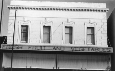 Stawell Historical Society Inc
Photograph, Green Grocers Shop at 150 Main Street Stawell
Business Premises 150 Main Street. Earlier owned by F. Allam who conducted a Green Grocers there. Now Accountants offices.Black and White photograph of a fruit shop facade. The building has a parapet top and cantilever veranda with a roll up awning underneath. The four windows on the top story have interesting window designs.Fresh Fruit and Vegetables stawell -
 Malmsbury Historical Society
Photograph (Item), "B/W Photo Boxing Day Picnic Parade, Main, Moffett & Brereton", Malmsbury c1920
People - "Main, Children; Moffatt, Nellie; Brereton, Betty; Swainston" Buildings - Town Hall Associated with - Boxing Day Picnic Parade -
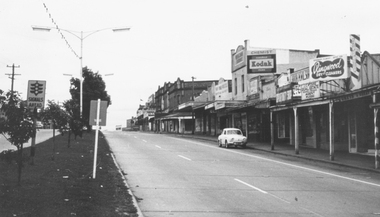
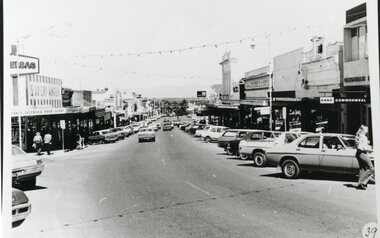 Stawell Historical Society Inc
Photograph, Main Street Stawell before the Mall
Stawell Main street before Mall looking West. Earles Supermarket on left Commonwealth Bark on right. Cars parked in Street.stawell streetscape