Showing 10931 items
matching land
-
 Lakes Entrance Historical Society
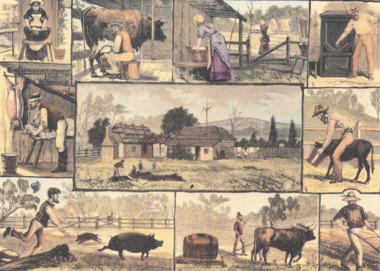
Postcard - Illustrated Australian News 1882, Tivoli Card and Paper, The Free Selector at Home
The illustrations are a light hearted look at the constant daily chores of a free settler and his family facing life on the landMono toned postcard featuring a collage of ten illustrations from the Illustrated Australian News 1882 titled The Free Selector at Homeagriculture, settlers, publication -
 The Beechworth Burke Museum Research Collection
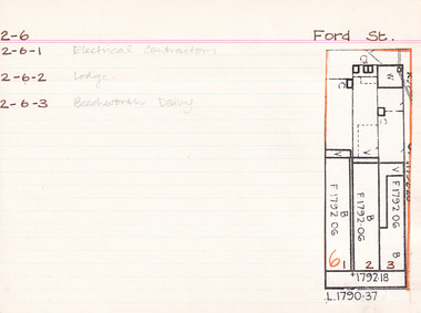
Card - Index Card, George Tibbits, Ford Street, Beechworth, 1976
Property - Ford Street, Beechworth - Section 2, Town Allotment 6 - (Note: also 2-6-1 Electrical Contractors, 2-6-2 Lodge and 2-6-3 Beechworth Dairy) - 100' x250' Ownership details and history - 28 Oct 1853 - W.H. Neuber 1861 - Galbraith, Andrew - Faulkner George, unlisted, J.S. Clark. land 22'x165', shop 32'x20' glass + deal fr. 2 stories, WB + sh. Bakery 25'x20' slabs + bark. Stable 20'x10' WB + do. 1861 - Steel, William, unlisted, J. Manson. land 11'x140' shop 10'x33' plate glass & cedar front, slabs + sh. Back 10'6"x34' WB + sh. 1861 - Joel, Abraham, unlisted, J. Manson, land 11'x140' shop 10'x33' plate glass + cedar front, slabs + sh. bark, 10'6"x34' WB + do. 1861 - J. Manson, unlisted, same, land 22'x25' (in rear) stable 14'x14' slabs + bark 1861 - George Gammon, unlisted, same, land 22'x165' shop 14'x31' glazed front. deal + WB slabs + sh. Kitchen 15'x12' store in rear 20'x10' do + bark 1863/4 - Eveleigh, J.L. (A. Galbraith in '63-'63) J.S. Clark land + prem as 1861. 1863/4 - Hall, Algernon, J. Manson. land + prem as 1861 1863/4 - Faulkner, baker & confectioner, J. Manson, land + prem as 1861 1863/4 - Manson, John as 1861 1863/4 - Gammon as 1861, Kitchen 15'x12' bk. resid. 24'x12' 1866 - Raphael, Julius, Tobias, Sally, tobacconists, J.S. Clark, land 22'x165 shop 20'x38' bk. bldg. glass fr. + sh. rf. Kitch. in rear 14'x12' WB = sh. Do. Stable 20'x10' slabs + bark. £115 1866 - Cunningham, James & Robert, ironmongers, John Manson, land 22'x165' shop 20'x33' plate glass + cedar fr. slabs + sh. rf. prem in rear 21'x34' WB + sh. rf. £110 1866 - Gammon, George, Druggist, same. land 22'x165' prem. 30'x20' + 24'x12' bk. bldg. 2 stories with plate glass + cedar shop front + sh. rf. Kitchen 15'x12' WB + sh. rf. 1871 - Brown, John, Barber etc. J.S. Clark. land + prem as 1866 £75 1871 - Cunningham, J&R, ironmongers, same. land + prem as 1866 + stable 13'x8' slabs + bark £96 1871 - Gammon, G. Druggist, same land + prem as 1866 £144 1876 - Walton, Wm. Tailor, Mary Clark. prem as 1866 exc. kitch 16'x12' + 20'x10' 1876 - Cunningham, J&R, ironmongers, same land 22'x165' prem 20'x30' deal fr. bk walls sh. roof Do. in rear 34'x21. WB + sh. rf. stable 20'x20' WB + ir. rf. £90 1876 - Gammon, George, Chemist, same land + prem as 1866 exc. no. 24'x12' bk £120 1884 - Armstrong, John, Draper, Mary Clark. shop 1884 - Cunningham Js. Ironmonger, same shop 1884 - Gammon, G. Chemist, same, shop + dwelling 1889 - Armstrong, as above £45 1889 - Cunningham, JS. as above. Cunningham, J&R, shop, prem + land £70 1889 - Gammon, G. Chemist, smae shop, dwelling pr. l. £80 1899-1900 - Armstrong. One shop owned, other ....? one 1900-1901 - Armstrong. double shop 1900 - Armstrong, John, draper, same shop + store £110 1900 - Bowen, Wm Johnston, Chemist, Kate Gammon, Sh. DW + L £65 1906 - Armstrong, Draper, same S+L £110 1906 - Bowen, Wm. Johnston, Chemist, Kate Gammon, shop, prem + land £65 Sect. 2, Town Allot. 6 - Note: 2-6-1 Electrical Contractors, 2-6-2 Lodge and 2-6-3 Beechworth Dairy Architectural Index Card - Brian Pump and Tony Dugan - Photographers beechworth, george tibbits -
 Kew Historical Society Inc
Photograph - Willsmere [Kew] Billabong, 1993
Willsmere Park is bounded by the the Yarra River, Green Acres Golf Club, Willow Grove and the Eastern Freeway. The land on which the park is now situated was bought by Thomas Wills at the Crown Land Sales of 1846 (Section 56). From the 1840s to the 1940s it was intensively farmed. The park is dominated by very large playing fields, while planting to the southern boundary was undertaken when the Eastern Freeway was built. It is only along the banks of the Yarra that there is any remnant native vegetation. Willsmere Park is of significance as an area of open land that remains from the flood plain that once dominated northern Kew. (Source: Kew Conservation Study, 1988)Original colour small format polaroid photograph of the 'Kew Billabong' in the Willsmere Park, taken on 16 September 1993."Willsmere Billabong 16.9.93"kew billabong, willsmere park, yarra river -- billabongs -
 Kew Historical Society Inc
Photograph - Yarra River in flood at the Willsmere Park, 1993
Willsmere Park is bounded by the the Yarra River, Green Acres Golf Club, Willow Grove and the Eastern Freeway. The land on which the park is now situated was bought by Thomas Wills at the Crown Land Sales of 1846 (Section 56). From the 1840s to the 1940s it was intensively farmed. The park is dominated by very large playing fields, while planting to the southern boundary was undertaken when the Eastern Freeway was built. It is only along the banks of the Yarra that there is any remnant native vegetation. Willsmere Park is of significance as an area of open land that remains from the flood plain that once dominated northern Kew. (Source: Kew Conservation Study, 1988)Original colour small format polaroid photograph of the Yarra River in flood at the Willsmere Park, taken on 16 September 1993."Yarra River at Willsmere Park Flooding 16.9.93"willsmere park, yarra river -- floods -- kew (vic.) -
 Kew Historical Society Inc
Photograph - Flooding in the Willsmere Park, 1993
Willsmere Park is bounded by the the Yarra River, Green Acres Golf Club, Willow Grove and the Eastern Freeway. The land on which the park is now situated was bought by Thomas Wills at the Crown Land Sales of 1846 (Section 56). From the 1840s to the 1940s it was intensively farmed. The park is dominated by very large playing fields, while planting to the southern boundary was undertaken when the Eastern Freeway was built. It is only along the banks of the Yarra that there is any remnant native vegetation. Willsmere Park is of significance as an area of open land that remains from the flood plain that once dominated northern Kew. (Source: Kew Conservation Study, 1988)Original colour small format polaroid photograph of flooding in the Willsmere Park, taken on 16 September 1993."Flooding of shared path from Willsmere Billabong 16.9.93"willsmere park, yarra river -- floods -- kew (vic.), kew billabong -
 Kew Historical Society Inc
Photograph - Flooding in the Willsmere Park, 1993
Willsmere Park is bounded by the the Yarra River, Green Acres Golf Club, Willow Grove and the Eastern Freeway. The land on which the park is now situated was bought by Thomas Wills at the Crown Land Sales of 1846 (Section 56). From the 1840s to the 1940s it was intensively farmed. The park is dominated by very large playing fields, while planting to the southern boundary was undertaken when the Eastern Freeway was built. It is only along the banks of the Yarra that there is any remnant native vegetation. Willsmere Park is of significance as an area of open land that remains from the flood plain that once dominated northern Kew. (Source: Kew Conservation Study, 1988)Original colour small format polaroid photograph of flooding in the Willsmere Park, taken on 16 September 1993."Flooding of Willsmere Park from Yarra 16.9.93"willsmere park, yarra river -- floods -- kew (vic.) -
 Kew Historical Society Inc
Photograph - Flooding of Willsmere Park from Yarra, 1993
Willsmere Park is bounded by the the Yarra River, Green Acres Golf Club, Willow Grove and the Eastern Freeway. The land on which the park is now situated was bought by Thomas Wills at the Crown Land Sales of 1846 (Section 56). From the 1840s to the 1940s it was intensively farmed. The park is dominated by very large playing fields, while planting to the southern boundary was undertaken when the Eastern Freeway was built. It is only along the banks of the Yarra that there is any remnant native vegetation. Willsmere Park is of significance as an area of open land that remains from the flood plain that once dominated northern Kew. (Source: Kew Conservation Study, 1988)Original colour small format polaroid photograph of flooding in Willsmere Park resulting from heavy rain on 15 September 1993."Flooding of Willsmere Park from Yarra 16.9.93"yarra river -- floods -- kew (vic.), willsmere park -
 Kew Historical Society Inc
Photograph - Willsmere [Kew] Billabong, 1993
Willsmere Park is bounded by the the Yarra River, Green Acres Golf Club, Willow Grove and the Eastern Freeway. The land on which the park is now situated was bought by Thomas Wills at the Crown Land Sales of 1846 (Section 56). From the 1840s to the 1940s it was intensively farmed. The park is dominated by very large playing fields, while planting to the southern boundary was undertaken when the Eastern Freeway was built. It is only along the banks of the Yarra that there is any remnant native vegetation. Willsmere Park is of significance as an area of open land that remains from the flood plain that once dominated northern Kew. (Source: Kew Conservation Study, 1988)Original colour small format polaroid photograph of Willsmere [Kew] Billabong on September 1993."Willsmere Billabong 16.9.93"yarra river -- floods -- kew (vic.), willsmere park -
 City of Kingston
Map - Parish of Moorabbin
Warning: This object includes historical language referring to First Nations Peoples which is no longer appropriate but has been recorded for historical purposes. Produced in 1853, this map shows the land holdings of European families. While the majority of holdings are small there are also large land holdings as can be seen with Henry Dendy's Special Survey. Of particular note is the "Reserve for Aborigines" which was established in approximately 1841 and consisted of over 830 acres. This area is the current location of Mordialloc township and Attenborough Park, in Mordialloc, is the last remnant of the reserve. An Alfred Sikes, possibly the surveyor/cartographer who drew this parish plan, purchased land in Berwick in 1854.A handrawn map on fabric, with blue markings representing the coastline to Port Phillip Bay, red markings representing a proposed train line to Mordialloc, major roads and street, as well as a "Reserve for Aborigines", which constituted approximately 830 acres. In the bottom right hand corner, the map has been signed and dated.Handwritten in ink: Alfred Sikes / 38 Collins St East / June. 1853moorabbin, mordialloc, dendy, port phillip bay, aboriginal reserve, attenborough park -
 Warrnambool and District Historical Society Inc.
Document, signatures and a sketch map
This document comes from the Ardlie collection. It is presumed that it is part of the material that belonged to William Ardlie, a prominent lawyer in Warrnambool in the 19th and 20th centuries. It is not clear if the document is a copy or an original. It is an 1886 document in which the purchasers of Allotments 127,128 and 129 in Coulstock Street, Warrnambool requested a change to the original land situation. They wished to eliminate a laneway shown on the original purchase document owned by Adam Bell and transfer the lane land to the new purchasers. The signatures on the document include Isabella Helpman, R.D. Burall, Adam Bell, Anthony Derrick and another signature not able to be deciphered. The sheet includes a sketch showing the proposed change to the land division. This item is of minor interest as a document from the 19th century dealing with a land transfer proposal by some prominent Warrnambool residents at the timeThis is a sheet of paper with handwriting, signatures and a sketch map, all in black ink. The page is a little yellowed with age. adam bell, warrnambool, wiliam ardlie -
 Shepparton RSL Sub Branch
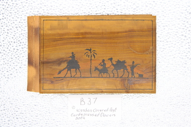
Postcard and Pressed Flowers Book, Wooden Covered Postcard and Pressed Flower Book from Jerusalem 1941, approximately 1941
souvenirs from the middle Eastern Countries during WW2A wooden covered book; 10 pages with post card and on left hand side and pressed flower arrangements on opposite page. Pages separated by translucent tissue paperBlack inked drawing depicting camels , cameleers and palm tree on front cover; central back wooden cover 'Jerusalem' printed Inside cover in handwriting " To Mother From Dad 18th January 1941" Book title " Flowers and Views of the Holy Land - Fleurs et vues de la Terre Sainte" postcard pressed flower book -
 Bendigo Historical Society Inc.
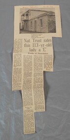
Newspaper - Lydia Chancellor collection: Specimen cottage
Specimen Cottage in Hargreaves Street Bendigo was built by stonemason James Brierley in 1856. He purchased the land at the first land sales in 1854. It is possibly the earliest building still standing in Bendigo. Further information "Written in Stone - The Story of pioneer Bendigo Stonemason James Brierley and his family" Written by Barbara Poustie. Published in 2017. Printed by Bendigo Historical Society.Bendigo advertiser from 04/10/1969. Article titled: Nat. Trust rates this 113 years old lady a "C" details the history of Specimen cottage. In red pen Bendigo Advertiser 4-10-69bendigo building, specimen cottage, james brierly, national trust -
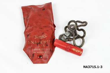 Whitehorse Historical Society Inc.
Functional object - Snake Bite Kit, circa 1960's
The Gunning family owned 20 acres of orchard and farm land in High Street Lower Templestowe and kept one of these kits in each vehicle and tractor. They didn't experience a snake problem until the late 1950's when land sub division around their property forced snakes into the area. The family lost one dog to snake bite in the early 1960's.Consists of a Wallet, tourniquet and lancet . 1.Wallet - small red plastic wallet with one press stud to close. Printed in gold on front: 'Sanax Snakebite Kit Sanax Pty Ltd Melbourne Australia 2.Tourniquet - rubber tourniquet looped through a metal clip used to tighten tourniquet. ' Sanax ' embossed on flat of metal clip. 3.Lancet - a three chambered cylindrical container made of red plastic. One end removes to reveal a lancet/ blade, the other end acts as a handle for the blade. Container holds instructions on a small roll of paper. The centre of the container can be be unscrewed to access crystals of permanganate of potash to put on the woundmedicine, first aid -
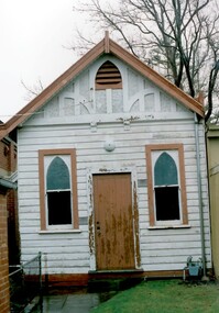 Surrey Hills Historical Society Collection
Photograph, Church of Christ, The Avenue, 1990
Built c 1889. The current Church of Christ is on the left. One of the foundation families was that of Mr and Mrs John Woodhead, who owned the land from Union Road to Warrigal Road and from Canterbury to Bona Vista Avenue in 1885. Mr Woodhead built 'Kirkland' in Union Road - in 1889/90. The land for the church was given by Mr Woodhead. Photograph taken in 1990.A coloured photograph of a weatherboard building with two windows at the front with brown painted surrounds, and a brown painted wooden door. There is a path leading to the door and looks to be a building on each side. There is a large tree in the background.Church of Christ/ Surrey Avenuekirkland, house names, union road, surrey hills, warrigal road, canterbury road, bona vista avenue, (mr) john woodhead, church of christ, churches -
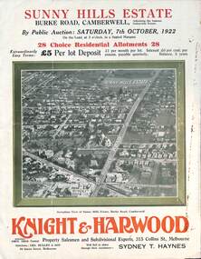 Melbourne Tram Museum
Ephemera - Real estate sale, Knight Harwood, "Sunny Hills Estate" - Burke Road Camberwell, Oct. 1922
Pamphlet advertising the sale of land at the "Sunny Hills Estate" Burke Road Camberwell 7-10-1922. Gives terms of sale, photos showing a nearby shopping centre, recently constructed houses, and plan of the subdivision. Land prices have been written in for each block on the pamphlet. Has a photo featuring Camberwell Junction with a tram, and Burke Road view with trams. Demonstrates the style of land sale pamphlet including the availability of tram services to prospective purchasers.Pamphlet - folded - printed in three colours of cream coloured paper with photographs and plans.has ink notes re sale price and notes.sale of land, trams, real estate, burke road, camberwell, sunny hills estate -
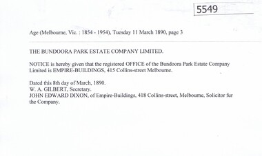 Greensborough Historical Society
Article, Bundoora Park Estate Company, 1890-1894
Bundoora Park Estate Company Limited was one of the many land development speculative companies operating in the Greensborough area in the 1890s. 5 p. of transcripts of five newspaper articles bundoora park estate campany limited, bundoora -
 Greensborough Historical Society
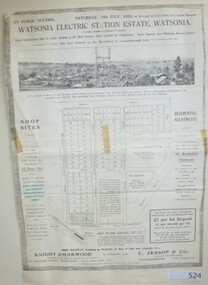
Advertising Leaflet, Knight & Harwood, Electric Station Estate, Watsonia, 19/07/1924
Photocopy of auction leaflet for land north of Watsonia Railway Station, Saturday 19th July 1924. Auctioneer Knight & Harwood.Photocopy of auction leaflet 1 p.watsonia, watsonia electric station estate -
 Eltham District Historical Society Inc
Photograph, Looking south along Main Road from Diamond Street Railway Crossing, Eltham, February 1968, Feb 1968
Luck Street enters Main Road from the left behind the Caltex garage. Note the house on right hand land.In February 1968 an unknown person took a series of photos from the Eltham Hotel at Pitt Street heading north along Main Road through the shopping centre to just north of Elsa Court covering the length of the section of Main Road which was duplicated shortly thereafter. Shows the condition and environment of the streesscape of Main Road, Eltham immediately prior to the duplication between Pitt Street and Elsa Court through the shopping centre. Also shows a number of shops and businesses that operated at that time.Black and white photographduplication, eltham, main road, diamond street, railway line, railway crossing, caltex service station, supa-value self service -
4th/19th Prince of Wales's Light Horse Regiment Unit History Room
Newspaper cutting, Drill Hall's Battle Over, 8 Dec 1994
The 4/19 PWLH Regiment was located at Bougainville Barracks, Carlton, until the land was sold off by Army for housing development.An article from the Herald Sun of Thursday 8 Dec 1994 about the closing of Bougainville Barracks in Park Street Carlton. It carries a photograph Col Frank Pearson with a Light Horse uniformed mannequin in front the 4th (late 20th Corangamite) Light Horse honour boardnewspaper, bougainville barracks -
 City of Moorabbin Historical Society (Operating the Box Cottage Museum)
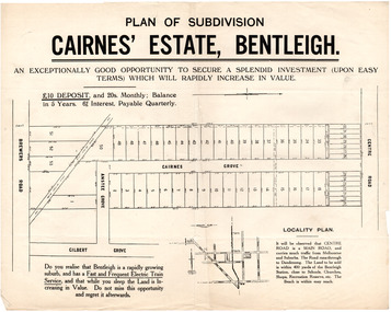
Flyer - Plan of subdivision for Cairnes' Estate, Bentleigh, mid 1920's
Land sales in the Municipality of Moorabbin increased when the train line from the City to Frankston was electrified.Example of the progress of the Municipality of MoorabbinExample of the progress of the Municipality of MoorabbinAdvertising flyer for auction of real estate sales - plan of building blocks for saleCairnes' Estate, Bentleigh 38 home sites and 14 business sitescentre road, cairnes grove, ansett grove, brewers road, bentleigh, land sales, real estate -
Tatura Irrigation & Wartime Camps Museum
Suitcase
Thomas Jervis Bowen, Land Sergeant, a guard at Camp 3? bought the suitcases from an inmate, passed on to his daughter.1 of 2 suitcases. Constructed from plywood obtained from lining of hut interior. Made by an unknown German/Italian internee. Acquired by a guard at camp 1 (Thomas Bowen). See C0192 for second suitcase.tatura, bowen, thomas, camp 3 garrison, personal, effects, travel, goods -
Tatura Irrigation & Wartime Camps Museum
Book, Settling, 1984
The relationship between Victorians and the land which has sustained them through the long human occupation of the state is the focus of the bookYellow cover. Illustration on front by Tom Roberts, Australian (1856-1931) - "The Artists Camp. Content info on back cover. 274 pages.victorians, dingle t, roberts t, tatura -
 Tatura Irrigation & Wartime Camps Museum
Document, Thomas Hogan
Hogan, Thomas, early selector of land, member of Rodney Shire Council and Rodney Irrigation Trust.|Shire of Rodney|TaturaDocument and photograph -
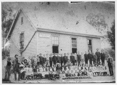 Ballarat Heritage Services
Photograph - Black and White, Yandoit Hill State School No. 691
The land for this school was donated by Carlo Gervasoni. When it closed it was moved to the corner of Main Road and Seventh Street, Hepburn Springs. Black and white photograph of three men standing either side of a number of school children of Yandoit Hill State School. yandoit, yandoit hills, yandoit creek, yandoit hill state school, gervasoni, hepburn springs -
 City of Kingston
Pamphlet - Black and white, Robert McCamish & John Gilpin (Vendors), For Private Sale Station Entrance Estate, Highett, 1930s
Sales plan for land in the suburb of Highett, bounded by Wickham Road, Railway Parade, Highett Road and Point Nepean Street. The developing urban area of Highett within the City of Kingston. This land sale pamphlet illustrates the subdivision of land within the municipality and the changing demographic of the district as new houses are constructed. The extension of the railway line from the city to Mordialloc opened up the land for development.Black and white pamphlet advertising for private sale the Station Entrance Estate, Highett. Incorporates a map of the estate bordered by Wickham Road, Railway Parade, Highett Road and Point Nepean Road. Handwritten in black ink on reverse: Station Entrance / Estate / Late [indecipherable]highett, land sales, estate -
 City of Kingston
Pamphlet - Colour, Fergusson & Mitchell Lith, Sandringham Rises, c. 1888
Sales plan for land in the suburb of Sandringham, bounded by Bluff Road, Bay Road and William Street, and incorporating Frances Street.The developing urban area of Highett (then called Sandringham) within the City of Kingston. This land sale pamphlet illustrates the subdivision of land within the municipality and the changing demographic of the district as new houses are constructed close to infrastructure.Colour pamphlet advertising for sale 35 lots in Sandringham Rises, Sandringham. Incorporates a map of the estate bordered by Bluff Road, Bay Road and William Street, including Frances Street.Handwritten in grey pencil next to the words 'THREE O'CLOCK': 1888 Handwritten in blue ben next to the words '& BUSINESS SITES': 1888land sales, sandringham, highett -
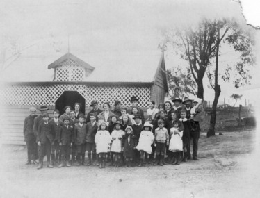 Ballarat Heritage Services
Photograph - Photograph - Black and White, Yandoit Hill State School No. 691, c1919, c1919
The land for this school was donated by Carlo Gervasoni. When it closed it was moved to the corner of Main Road and Seventh Street, Hepburn Springs.A number of adults, and students of Yandoit Hill State School, stand in front of the playground shed. One man is in an AIF uniform, and another has a slouch hat on. yandoit creek, yandoit hills, education -
 Sunbury Family History and Heritage Society Inc.
Photograph, Rupertswood Restoration Society, Rupertswood Mansion, C1980S
The mansion in the photograph is Rupertswood, in Sunbury, which William Clarke built in 1874 - 76 on land that he had purchased in 1840.Since Rupertswood Mansion was built it has been the venue a variety of events and owners as well as the Clarke family. The property is now owned by the Salesian Order and is a co-educational secondary college.A non-digital coloured photograph in post card format with a view through trees of a grand Victorian mansion with a tall tower at its main entrance.Printed on the back RUPERTSWOOD MANSION SUNBURY VICTORIA BUILT 1874 - 76/ RUPERTSWOOD RESTORATION SOCIETYrupertswood mansion, william j.t. clarke -
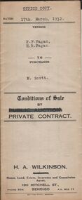
 Bendigo Historical Society Inc.
Document - H.A. & S.R. WILKINSON COLLECTION: CONTRACT OF SALE
Conditions of sale by private contract dated 17th March, 1932 between E.F. Fagan & H.R. Fagan (sellers) and M. Scott (buyer) for land situate 69 Neale Street Bendigo being Crown allotment 102, section H described in certificate of title volume 4451 folio 890162, together with 5-roomed weatherboard and brick dwelling and all sundry. Price 300 pounds. Vendor copy.organization, business, h.a. & s.r wilkinson real estate -
 Bendigo Historical Society Inc.
Document - H.A. & S.R. WILKINSON COLLECTION: CONTRACT OF SALE
Conditions of sale by private contract dated 17th March, 1932 between E.F. Fagan & H.R. Fagan (sellers) and M. Scott (buyer) for land situate 69 Neale Street Bendigo being Crown allotment 102, section H described in certificate of title volume 4451 folio 890162, together with 5-roomed weatherboard and brick dwelling and all sundry. Price 300 pounds. Office copy.organization, business, h.a. & s.r wilkinson real estate