Showing 11114 items
matching planning
-
 Bendigo Historical Society Inc.
Document - MINING PLAN longitudinal section, Circa 1880's
Mining plan: Showing shafts and layout of Gibbs, Ballerstedt and wells, Humboldt Co., Great Central Victoria Co., Adventure and Advance (in two pieces)topic, mining, plans, gold mines bendigo, gibbs, ballerstedt, wells, humboldt co., great central victoria co., adventure and advance -
 Bendigo Historical Society Inc.
Map - MINING PLAN, Circa 1880's
Mining Plan: showing the following companies: New Chum and Victoria Co., South Victoria Co., Lansell's 180, Victoria Quartz Mining Co.topic, mining, plans, mining in bendigo, new chum and victoria co., south victoria co., lansell's 180, victoria quartz ming co. -
 Lakes Entrance Historical Society
Photograph - Skate Park, Lakes Post Newspaper, 1999
Colour photograph Aaron Stroud of Skateboard Park Planning Committee, explaining concept to David Treasure East Gippsland MLA. Lakes Entrance Victoriasporting facilities, management -
 Clunes Museum
Drawing - CONCEPT DRAWINGS/PLANS
.1 LINE DRAWING IN COLOUR ON VELLUM OF A CANNON .2 LINE DRAWING ON VELLUM OF SECTION AND PLAN OF RETAINING WALL LAYOUT - POSSIBLY BASE FOR CANNONcannon, drawings, plans -
Lakes Entrance Historical Society
Book, Lake Tyers Beach Strategy Plan, 1990
Draft report of the Strategy Plan on Lake Tyers Beach and surrounds for the Shire of Tambo, aspects considered, background of area, recommendations, implementation and foreshore managementgovernment -
 Bendigo Historical Society Inc.
Map - MANDURANG 1, Examined 11/12/1879
Map: Mandurang 2, County of Bendigo. Parish plan Examined by W. S. Stephen 11.12.79 W. E. Porter Draughtsman July 1879map, bendigo, parish plan, mandurang, w. s. stephen, w. e. porter -
Port Melbourne Historical & Preservation Society
Plan - Proposed Beacon Cove Development plan by Sandridge City Development Company Pty Ltd, 17 July 1989
A photocopy of a detailed of areas 2, 6, 9, 10, & 13 of the plan for Beacon Cove from the Sandridge City Development Company Pty Ltd.sandridge city development company pty ltd, local government - city of port melbourne, beacon cove -
 Greensborough Historical Society
Newspaper Clipping, Diamond Valley News, Apollo Parkways School may start with 220 pupils, 24/10/1978
In 1978 Apollo Parkways Primary School [AP5184] was in the planning stages. In this article the Principal is named and plans for permanent buildings are discussed. The school opened in 1979.Information about the development of a new school in the Greensborough area.Photocopy of newspaper article,Date written on side.apollo parkways primary school, frank miller -
 Kew Historical Society Inc
Photograph - Cosy Five Roomed Rough Cast Bungalow, Kew, J E Barnes, c.1920
Subdivision plans are historically important documents used as evidence of the growth of suburbs in Australia. They frequently provide information about when the land was sold on which a built structure was subsequently constructed as well as evidence relating to surveyors and real estate and financial agents. The numerous subdivision plans in the Kew Historical Society's collection represent working documents, ranging from the initial sketches made in planning a subdivision to printed plans on which auctioneers or agents listed the prices for which individual lots were sold. In a number of cases, the reverse of a subdivision plan in the collection includes a photograph of a house that was also for sale by the agent. These photographs provide significant heritage information relating house design and decoration, fencing and household gardens. The photograph is also aesthetically significant as it was taken by J. E. Barnes, a nationally significant photographer. He was the most important photographer to have worked in Kew. He was active as a photographer in the district from c.1906 until his death in 1921. Best known as 'the Embarkation Photographer' (see the Australian War Memorial collection), Josiah Earl Barnes was also the official photographer employed by the Borough (and later Town, then City) of Kew. He clearly also completed commercial jobs for local businesses, as is the case in this photograph of a house for a local real estate and financial agent. A modest weatherboard house with rough-cast rendered walls. The gabled entrance incorporates elements of the Japanese aesthetic. The strong lines of the dark timber gable are reinforced by the colour and shape of the pickets in the fence. In contrast to an earlier period, the chimneys appear truncated. The use of extensive double-hung sash windows in the front rooms reflects a new interest in light in houses. The use of separate sunshades over windows in an earlier period is here replaced by an extension of the roofline over the window. The photographer Josiah Barnes died in 1921; so, the photograph of the house must predate this date. The location of the house, which was advertised for sale, has to date not been identified. Illegible inscription. Photographer's information on mount.josiah earl barnes, j e barnes, photography - kew, interwar housing - victoria, 1920s housing - kew -
 Kew Historical Society Inc
Photograph - 2 Young Street, Kew, Paramount Photos, 1920s
Subdivision plans are historically important documents used as evidence of the growth of suburbs in Australia. They frequently provide information about when the land was sold on which a built structure was subsequently constructed as well as evidence relating to surveyors and real estate and financial agents. The numerous subdivision plans in the Kew Historical Society's collection represent working documents, ranging from the initial sketches made in planning a subdivision to printed plans on which auctioneers or agents listed the prices for which individual lots were sold. In a number of cases, the reverse of a subdivision plan in the collection includes a photograph of a house that was also for sale by the agent. These photographs provide significant heritage information relating house design and decoration, fencing and household gardens.A prepossessing, large home constructed in the Arts and Crafts style. Located on the banks of the Yarra at 2 Young Street, Kew overlooking the factories of Richmond, the design of the house takes account of the gradient with the addition of a level below the front entrance. The elegant roof includes a number of projecting gables and dormers. The gables are typically half-timbered and rendered. In addition to the asymmetrically placed portico, there are at least two open verandas, supported by timber pillars and with roofs that reflect the overall pitch of the roof of the housereal estate photographs, 2 young street - kew -
Federation University Historical Collection
Book, C.E. Bristow, Government Printer, Northern Territory of South Australia Government Geologist's Reports on Recent Mineral Discoveries, 1908
Foolscap government geologist's Report including information on:- Pine Creek District; Brock's Creek, Anson Bay, Northern Territory Boring Operations Images Include: 'Mob of Blacks ad Tamarind Tree near Cliff Head, Anson Bay; Diamond Drill Boring Camp, near Cliff Head, Anson Bay, Wannomi Swamp; Daly River Crossing; Battery and Chinese Miners, Driffield Sketch Plan of the Mount Davis Copper FIeld, Sketch Plan Shewing POsition of Mineral Localities and Claims Near Wolfram Camp, Sketch PLan of the Pin Creek District Shewing Metalliferous Localities. h.y.l. brown, mining, boring, aborigines, aboriginal, chinese, south australia -
 Melbourne Tram Museum
Document - Report, Keolis Downer, "Business Plan 2014-17", 2014, 2015
Set of two reports from Keolis Downer, operators of Yarra Trams presenting their business plans in a report sent to employees. .1 - four fold special size document titled "Business Plan 2014-17" giving Vision, Mission, Corporate Objectives, Achievements and Corporate Scorecard. Has a stapled insert titled "4Q's". .2 - 24 page full colour report printed on light card, white wire spiral bound, titled "Business Plan 2015-19" giving Vision, Mission, values, PTV Strategic Themes, Achievements, Concerns, Corporate results, Objectives and targets..1 - has "Mr. Hermes Gabriel" written on the front cover. .2 - has a label with "Gabriel Hermes" written on it.trams, tramways, yarra trams, keolis downer, plans, ptv -
Kew Historical Society Inc
Flyer - 60 Pakington Street, Kew
Subdivision plans and real estate flyers/brochures reveal a number of aspects of urban development and history. The Kew Historical Society's collection of these plans, as well as advertisements extracted from magazines, cover key aspects of community development and architectural history of Kew and Kew Eat as well as surrounding suburbs. While most of the plans in the collection were gifted to the Society by the former City of Kew, a number of other plans and advertisements have been donated by individuals, of which this is an example. Single page illustrated flyer, advertising 60 Pakington Street, Kew for sale. Annotation in pen and ink at right.neville collection, 60 pakington street -- kew (vic.), real estate advertisements -- kew (vic.) -
Kew Historical Society Inc
Flyer - 45 Pakington Street, Kew
Subdivision plans and real estate flyers/brochures reveal a number of aspects of urban development and history. The Kew Historical Society's collection of these plans, as well as advertisements extracted from magazines, cover key aspects of community development and architectural history of Kew and Kew Eat as well as surrounding suburbs. While most of the plans in the collection were gifted to the Society by the former City of Kew, a number of other plans and advertisements have been donated by individuals, of which this is an example.Single page illustrated real estate flyer advertising 45 Pakington Street, Kew for sale by auction. Annotation in pen and ink at rightpeter neville, real estate advertisements -- kew (vic.), 45 pakington street -- kew (vic.) -
Kew Historical Society Inc
Booklet - Old Kew Golf Links Estate, 1926
Subdivision plans and real estate flyers/brochures reveal a number of aspects of urban development and history. The Kew Historical Society's collection of these plans, as well as advertisements extracted from magazines, cover key aspects of community development and architectural history of Kew and Kew Eat as well as surrounding suburbs. While most of the plans in the collection were gifted to the Society by the former City of Kew, a number of other plans and advertisements have been donated by individuals, of which this is an example.8-page brochure advertising 80 residential home sites for sale in a subdivision called the 'Old Kew Golf Links Estate'. These sites had historic importance in Kew's history as they had previously belonged to Kodak Pty Ltd who were refused permission by Kew Council to use the land for industrial development. The estate, advertised was advertised as being within five miles of Melbourne. The brochure is notable as it includes photographs of Kew East Primary School, the former Kew Golf Club clubhouse, and 'The Moorings' Boathouse (aka Chipperfield's Boat House). The aerial photograph, overlaid with names of notable sites, on the final page is of interest as it shows the area before the intrusion of the Eastern Freeway, which resulted in changing the course of a section of the Yarra River. old kew golf links estate, subdivision -- kew (vic.), subdivisions -- kew east (vic), chipperfield's boathouse, kew east primary school, kew golf club -
Kew Historical Society Inc
Booklet - Yarraleen Estate, Bulleen, c.1966
Subdivision plans and real estate flyers/brochures reveal a number of aspects of urban development and history. The Kew Historical Society's collection of these plans, as well as advertisements extracted from magazines, cover key aspects of community development and architectural history of Kew and Kew Eat as well as surrounding suburbs. While most of the plans in the collection were gifted to the Society by the former City of Kew, a number of other plans and advertisements have been donated by individuals, of which this is an example.Original 8-page booklet advertising a new residential development in Bulleen entitled 'Yarraleen'. The glossy multi-colour brochure includes historic and contemporary photographs of the Yarra Valley, graphic designs of potential residential development, photographs of key facilities (Marcellin College, Golf links, local swimming holes, the Beaver Swim School, Carey Grammar School Oval and grandstand, shopping strips, and farmland).subdivisions -- bulleen (vic.), yarraleen estate -
Kew Historical Society Inc
Plan - 30 Choice Home Sites in Kilby Road, Meldrum Street and Fairway Drive, 1965
Subdivision plans and real estate flyers/brochures reveal a number of aspects of urban development and history. The Kew Historical Society's collection of these plans, as well as advertisements extracted from magazines, cover key aspects of community development and architectural history of Kew and Kew Eat as well as surrounding suburbs. While most of the plans in the collection were gifted to the Society by the former City of Kew, a number of other plans and advertisements have been donated by individuals, of which this is an example.Original 4-page, bifold brochure, one of two in the collection, of home sites created following the creation of the Eastern Freeway which separated a section of land owned by the Kew Golf Club from the main course. The new estate featured 30 lots in Meldrum Street, Kilby Road and Fairway Drive. subdivisions -- kew east (vic.), subdivisions -- kew (vic.), kew golf club -
Kew Historical Society Inc
Plan - 30 Choice Home Sites in Kilby Road, Meldrum Street and Fairway Drive, 1965
Subdivision plans and real estate flyers/brochures reveal a number of aspects of urban development and history. The Kew Historical Society's collection of these plans, as well as advertisements extracted from magazines, cover key aspects of community development and architectural history of Kew and Kew Eat as well as surrounding suburbs. While most of the plans in the collection were gifted to the Society by the former City of Kew, a number of other plans and advertisements have been donated by individuals, of which this is an example.Original 4-page, bifold brochure, one of two in the collection, of home sites created following the creation of the Eastern Freeway which separated a section of land owned by the Kew Golf Club from the main course. The new estate featured 30 lots in Meldrum Street, Kilby Road and Fairway Drive.subdivisions -- kew east (vic.), subdivisions -- kew (vic.), kew golf club -
Glen Eira Historical Society
Plan - Nettalie
An A4 photocopy of the 'Plan of the Caulfield Road District' dated 1867. This plan shows the location of the properties owned by A Shaw and Blundell on Balaclava and Orrong Roads where Nettalie is situated. The plan includes all the landowners listed where their property was, the street names and other landmarks of 1867 including railways, hotels and reserves.caulfield, caulfield north, elsternwick, st kilda east, parish of prahran, parish of moorabbin, caulfield road district, melbourne and brighton railway, rosstown railway, elsternwick railway station, caulfield railway station, rosstown railway station, murrumbeena railway station, baptist church, paddy’s swamp reserve, cemetery reserve, leman swamp reserve, caulfield racecourse reserve, brighton cemetery, the vine caulfield hotel, the tam o’shanter hotel, melbourne hunt hotel, royal hotel, hotham street, horne street, nepean highway, north road, orrong road, dandenong road, princes highway, kooyong road, alma road, inkerman road, balaclava road, glen eira road, glen huntly road, hawthorn road, cemetery road, bambra road, redan road, kambrook road, neerim road, booran road, racecourse road, grange road, koornang road, murrumbeena road, crosbie road, kangaroo road, poath road, ford w, lempriere, cople j, riddell j c, manifold j, testar t, billing r h, semple, blundell, shaw a, butchart g, stephen j w, stephen g sir, hart j, duncan g, blackie r, stephen f, mccombie t, woollaston h, higgins j, lloyd j c, daish j, mcleod j, hughes d, wilson a, jamieson g, webb g h, renwick s, pennington h, dunn j, kirkpatrick w, ricketson w, toad a, sayce j, watts t, widgery, store, guess j, anketell j, clack j, sissen w, clayton g, dickson d, bevan j, hart t, anderson j, hart mrs, webb h, masters s, waghorn j, hemming c, hiam c, farquhar w, newing t, payne t, cooper r, snipe s, chambers j, forster w, summers r, harriman b, warrick, o’connell, long j, peck r, cochrane c, murray ross w, evans c, kennedy j, maclean n, forster, lyall w, dean j, newton h, looker w, baker c, johnston, crosbie j, kerr, jones, parr, nelson c, montgomery l, parsons w, james j c, sibon c, smith sydney w, plans, maps, land subdivisions, land use, settlements, roads and streets, hotels, churches, police stations, post offices, land surveys, railway stations, railways, schoolhouses, commerce, clergy residences, official buildings, local government, road districts -
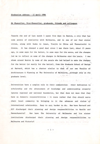 Robin Boyd Foundation
Document - Speech, Professor George Seddon, Graduation address, 12.04.1986
A graduation address given by Professor George Seddon, Dean of Faculty of Architecture and Planning, University of Melbourne in 1986. The speech compares urban planning and architecture in Melbourne and Boston. Seddon mentions Boyd positively as a former Melbourne University student and a key writer and thinker on Australian architecture and planning (pages 5&6).Typewritten, A4, 12 pages. Plus with compliments card from Seddon, noting to view pages 5 and 6.melbourne, boston, robin boyd, george seddon, kevin lynch, university of melbourne -
Glen Eira Historical Society
Plan - Bokhara Road, 28, Caulfield South
A hand drawn plan (75mm x 147mm) of the house at Bokhara Road, 28, Caulfield, undated and unattributed. The plan includes notes about the dimensions and fittings of the house.bokhara road, caulfield south -
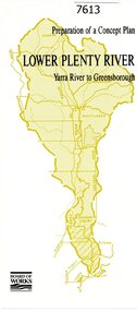 Greensborough Historical Society
Pamphlet, Melbourne & Metropolitan Board of Works, Lower Plenty River: Yarra River to Greensborough: preparation of a concept plan, 1990
This pamphlet outlines a proposed concept plan for the lower Plenty River, Greensborough to Heidelberg. The plan would focus on preserving and enhancing the aesthetic, recreational and conservation potential of the waterway.2 p., illus., tri-fold pamphlet. 2 copiesplenty river, melbourne water corporation, board of works -
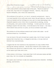 Robin Boyd Foundation
Document - Manuscript, Robin Boyd, Albert Park Protection League
Criticism of the state of Albert Park, Melbourne, preparation of a current map, the need for a Master Plan of buildings, plantings, furniture. Criticism of buildings. Suggests a plan to plant and paint.This appears to be a lecture.Typewritten with pencil edit and notes, quarto, 4 pages. (Two copies)Small paper square included with Monday, January 24 calendaralbert park, macrobertson girls high school, planting, building, furniture, robin boyd, manuscript -
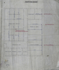 Federation University Historical Collection
Plan, Ballarat Technical Art School Plan of Proposed Fittings, 1914, 05/03/2014
The Ballarat Technical Art School was a division of the Ballarat School of Mines. A custom built building was opened in 1915. A plan on linen showing the proposed fittings for the new Ballarat Technical Art School Building built in the grounds of the Ballarat School of Mines. The plan has been hand coloured and designates rooms for freehand and plant drawing, model and cast drawing, Modelling Room, Light and Shade Room, Lecture room, Head Master's Office, attendant's office, cloakroom, storeroom, Castings Room, Sheet 7 W.J.G. 5.3.14ballarat technical art school, buildings, ballarat school of mines, plan -
 Bendigo Historical Society Inc.
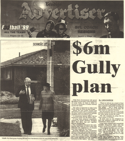
Document - LONG GULLY HISTORY GROUP COLLECTION: $6M GULLY PLAN
Photocopy of the front page of the Bendigo Advertiser Friday August 20, 1999. The article titled $6m Gully plan by Linda Barrow mentions a building plan for the area. It has a photo of Ron Best MLC and Housing Minister Ann Henderson on a tour of Long Gully. There is a small article about Phil White, The Herald Sun/Monash University Teacher of the Year Award.bendigo, history, long gully history group, the long gully history group - $6m gully plan, bendigo advertiser20/8/1999, ron best, ann henderson, jacquelene hunt, phil white, golden square secondary college, herald sun, monash university, graeme fryar, racv, ashmans, linda barrow -
Bendigo Historical Society Inc.
Map - CAMPBELL COLLECTION: BENDIGO AND DISTRICT MAPS, 8-7-29
Map. Rifle Range, Parishes of Wellsford and Sandhurst. Scale 20 chains to 1 inch. Total area in plan is 5916 acres. Wallan and Bendigo Railway to Axedale Township and station 8 miles, to Longlea Railway Station 2 1/2 - 3 miles. Rifle Range. Compiled in W.P.B. from Assessment and Parish Plans, by H.A.D. 8-7-29H.A.D.(Darby).map, bendigo, allotments -
University of Melbourne, Burnley Campus Archives
Plan, Burnley Gardens. City of Richmond. Parish of Jika Jika - County of Bourke, 1927
Plan showing Burnley Gardens - bounded by Swan St to N, Yarra River to E, Richmond Park on S and W side. Photo-lithographed at Dept. of Lands & Survey by W.J. Butson. Plan shows old orchard, fowl sheds, coops and yards, milking shed, silo, nursery, glasshouse, fattening pens, dairy, garden, orchards area in S.W. area.burnley gardens, orchards, sheds, nursery -
 Bendigo Military Museum
Booklet - HANDBOOK of VOLUNTARY AID DETACHMENTS 1942 & 1943, Aust Army, 1942
VAD. To supplement the medical services of the Navy, Army and Air Force in time of War. Part of a collection re Bendigo Voluntary Aid Detachment. Refer Cat 7028 for the collection.1. This is a small pocket book. The cover is a light Khaki. Printing is in black ink. Title - Handbook of Voluntary Aid Detachments, Aust. Part 1, 1942. It has 23 pages of plans, army org and uniforms for VAD girls. 2. Small pocket book as above. Dated 1943. It has 24 pages of plans, Army Org and uniforms for VAD girls.1. Written on front cover is “D. M. Guest” Inside are numerous pencil amendments to regulations. 2. On front cover is a fraction of a black rubber stamp like a Post Office stamp.ww2, vad, booklets -
 Melbourne Tram Museum
Pamphlet, Yarra Trams, "Power supply upgrade project - J. S. Grey Reserve West Preston", Jul. 2016
Digital image of a folded A4 pamphlet titled "Power supply upgrade project - J. S. Grey Reserve West Preston", about the construction of a new sub-station on the reserve, gives construction dates, impact, site plan, elevation plan, reason or need for the sub-station for tram power upgrades. Dated July 2016. A4 print made for files.trams, tramways, substation, power supply, yarra trams, west preston -
 Melbourne Tram Museum
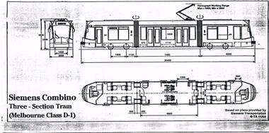
Drawing, Transit Australia Publishing, "Siemens Combino Three Section Tram (Melbourne Class D1)", "Siemens Combino Three Section Tram (Melbourne Class D2)", Nov. 2002
Set of two drawings of the Melbourne Siemens Combino Trams, class D1 and D2, produced by Transit Australia, November 2002, based on plans from Siemens Transportation. Side and end elevations and floor plans with leading dimensions. .1 - "Siemens Combino Three Section Tram (Melbourne Class D1)" .2 - "Siemens Combino Five Section Tram (Melbourne Class D2"trams, tramways, drawings, tramcars, d class, tramcar design