Showing 8986 items matching "ah-15"
-
 Eltham District Historical Society Inc
Photograph, Liz Pidgeon, Heritage Excursion; East of Eltham, 6 Sep 2014, 20 May 2017
Newsletter No. 218, September 2014 September Excursion - East of Eltham Walk In Newsletter No. 197, March 2011, there was a brief history of Crown Allotment 15 Section 5 Parish of Nillumbik (CA 15) a parcel of land of a quarter of a square mile extending from Eucalyptus Road to Reynolds Road at the eastern extremity of Eltham. From the 1940s it was known as Stokes orchard. In later years it has been subdivided for residential purposes but leaving significant areas as power line and water supply reserves and bushland reserves that are habitat for the threatened For our excursion on 6th September we intend to walk through CA 15 to a bushland reserve east of Reynolds Road. The walk will traverse the boundary between suburban Eltham and the non-urban areas to the south and east. This is a pleasant walk through residential areas and bushland. Along the way we will discuss the early and more recent history of CA 15 as well as local natural history and geology. This walk is about 3.5 km in length and will take 2 to 2.5 hours. It will start at 2pm at the corner of Eucalyptus Road, Pitt Street and Nyora Road.Born Digitaleltham east, eltham district historical society, heritage excursion, activities, nyora road, reynolds road, gum tree road reserve, diosma road, stokes orchard, eucalyptus road -
 Melbourne Tram Museum
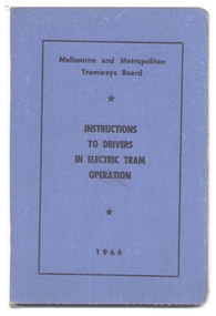
Book, Melbourne & Metropolitan Tramways Board (MMTB), "Melbourne and Metropolitan Tramways /Electric System /Instructions to Drivers in Electric Car Operation", 1966
Forty Eight page, side staple book within blue Rexene covers. Titled "Melbourne and Metropolitan Tramways /Electric System /Instructions to Drivers in Electric Car Operation" Dated 1966. Printed by Regent Press Pty Ltd, 457 Plenty Road, Preston. Provides in a Q & A format, instructions to drivers in electric car operation, photos of various types of controllers, an A.B.C. for tramways drivers - "always" points to remember and has a reference index. Copy 1 - has telephone numbers of Training School and specific pointers re Regulations 106 and 107 and some of the Q&A have been circled in blue. This copy was imaged. The May 1974 instructions of "Tram car Braking on Greasy Rails", has adhesive tape remnants. Copy 2 - 1/5/1975 instructions loose inside the book. Copy 3 - added 29/5/2014 from the collection of R. Wearne. Copy 4 - added 15-6-2015 - from Ron Scholten donation of 11-4-2015. Copy 5 - added 14-12-2015 from donation of Norm Cross 11-10-2009. Had the instructions for Tram car braking on Greasy Rails appended inside front cover - loose, with adhesive tape remnants. Relocated to Reg Item 2913.copy 3 has 7 numbers in ink inside the front cover, a number of questions in the book have been circled., copy 4 - has numerous changes to issue on page 1, ink crosses on specific questions., copy 5 - has "K.T. Hall Works Manager" in ink on inside of front cover, and notes on pages 15, 16, 17, 19, regarding the use of the motor cut out switches.trams, tramways, mmtb, drivers, training, instructions, motormen -
 Puffing Billy Railway
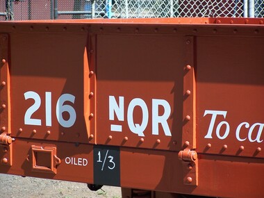
216 NQR - Open Medium Truck, 15/ 1/1914
The NQRs were the standard Medium open goods wagon. Generally the sides and ends were removable thus providing a totally flat truck. Three long drop-down doors formed the sides thus allowing easy loading and unloading. 218 of these goods vehicles were built between 1898 and 1914 ? numbered 1 - 218. Originally, these wagons carried the code letter R as they were built with sides and ends. They later had the R removed. Unlike the Broad Gauge, VR's 2 ft 6 in (762 mm) narrow gauge network never had four-wheeled wagons (aside from a handful of trolleys). Because of this, a single design of open wagon emerged and this was the only type of wagon ever used on these lines. This was the NQR class, a wagon with the same length and loading capacity as a Broad Gauge four-wheeled open wagon to make transferring freight between the gauges easier. The wagons, numbered 1 through 218, were built between 1898 and 1914. The wagons used the same underframe as most other non-locomotives on the VR Narrow Gauge. Letters and numbers were originally painted only on the end bulkheads and doors, both of which could be removed as traffic dictated, and this made wagon identification difficult until the decals were transferred to the underframes of each wagon In the 1910s some NQRs were provided with removable wood and steel frameworks with canvas roof canopies and side curtains, and internal seating to supplement the rest of the passenger stock during busy holiday periods. Puffing Billy has re-created these for emergency capacity. Five more NQRs, numbered 219-223, were built between 1990 and 1992 initially for passenger use so were fitted with the removable frames Vehicle Length 25 feet 2 inches ( 7671 mm) Coupled Length 27 feet 4 inches (8330 mm) Width 6 feet 3 inches (1905 mm) Weight 5 tons Capacity 11 tons Built 1898 - 1915 (1992) Number Built 218 (223) In use 14 To be restored 6 216 NQR - Open Medium Truck 15/ 1/1914 NWS Built new VR Service History *NQR 216.VA - 15/ 1/1914 NWS Built new - / /1926 - To NQ 216.VA - Puffing Billy Service History or Notes April 2016 - Trial fitting of brake rigging May 2016 - Riveting of the draw gear castings in progress July 2016 - Riveting of the draw gear castings in progress. Truss rods threaded ready for fitting Aug 2016 - Rivetting of the draw gear castings in progress. Draw gear and couplers being evaluated. Sept 2016 - Riveting of the draw gear castings in progress. Draw gear and couplers being overhauled. Oct 2016 - Riveting of the draw gear castings completed, brake piping installed. Nov 2016 - Floor installed, under framing welding completed, fitting of side doors, hand brake fitted Dec 2016 - Car Workshop - Side panels fitted, end panels to be fitted Jan 2017 - Couplers fitted, brake rodding connected, transferred to Emerald for bogie work and sign writing. Feb 2017 - At Emerald - Tyres machined, braking system being prepared Historic - Victorian Railways - Narrow Gauge Rolling Stock - NQR Open Medium Truck216 NQR - Open Medium Truck made of Steel and metal216 NQRpuffing billy railway, pbr, rolling stock , 216 nqr - open medium truck, victorian railways, nqr - open medium truck -
 Orbost & District Historical Society
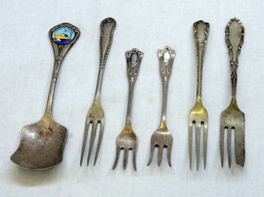
cutlery, first half 20th century
MS Princess of Tasmania was an Australian-built roll-on/roll-off passenger ship, built by the State Dockyard in Newcastle, New South Wales for the Australian National Line. Laid down on 15 November 1957, she was launched on 15 December 1958. The Princess of Tasmania sailed on her maiden voyage on 23 September 1959. On entering service, she was used on the Devonport to Melbourne route across Bass Strait. The ship continued operating until 1972, Five silver-plated forks and one spoon. The sugar spoon is a souvenir of the Princess of Tasmania. 1590.2 and .5 are narrow forks. 1590.3 and .4 have splayed tines. 1590.6 is a cake fork.On back of spoon : EP&NS *1 Various marks on backs of forks with EP&NScutlery silver-plated princess-of-tasmania -
 Melbourne Legacy
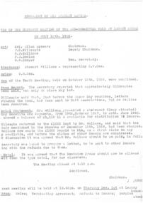
Document - Document, minutes, Biography of Sir Stanley Savige, 1960
Minutes from the 11th meeting of the committee held at Legacy House on 15 July 1960 reveals that 2000 copies of the book had been sold but sales were slowing. Because minutes of the 9th and 10th committee meetings are missing, information on the project is incomplete, but these minutes refer to the fact that the author wanted his loan of $1000 to be refunded, reversing his advice in the minutes of the 15 December 1958. The copy of the financial statement noted as attached to the minutes is missing.An indication of possible sales results of the sale of the biography of Sir Stanley Savige.One quarto size sheet of copy paper, carbon copy of minutes of a meeting about the biography.savige book, biography -
 Melbourne Tram Museum
Document - Notices to Traffic Staff, Melbourne & Metropolitan Tramways Board (MMTB), "Traffic signal lights Nicholson & Gertrude Sts, 1968
Set of three notices glue to one backing sheet: 1 - "Traffic signal lights Nicholson & Gertrude Sts. = C 1297, dated 23/1/1968 2 - Reinstallation of crossover in Dandenong Road , east of Chapel St - C1308, 15/2/1968 3 - Scholar Concession tickets - re use of these tickets on public holidays, and ability to pay a "build up" fare for extension of travel using the Concession ticket - dated 15/2/1968.Yields information about misc. matters of early 1968.Set of 3 notices printed, and glue to a sheet of paper on both sides.tramways, scholar's tickets, traffic lights, gertrude st, nichsolson st, dandenong road -
 Flagstaff Hill Maritime Museum and Village
Domestic object - Spoons, c. 1878
This tea spoon is from the wreck of the LOCH ARD, a Loch Line ship of 1,693 tons which sailed from Gravesend, London, on 2 March 1878 with 17 passengers and a crew of 36 under Captain George Gibbs. “The intention was to discharge cargo in Melbourne, before returning to London via the Horn with wool and wheat”. Instead, on 1 June 1878, after 90 days at sea, she struck the sandstone cliffs of Mutton Bird Island on the south west coast of Victoria, and sank with the loss of 52 lives and all her cargo. The manifest of the LOCH ARD listed an array of manufactured goods and bulk metals being exported to the Colony of Victoria, with a declared value of £53,700. (202 bills of lading show an actual invoice value of £68, 456, with insurance underwriting to £30,000 of all cargo). Included in the manifest is the item of “Tin hardware & cutlery £7,530”. This teaspoon is one of 482 similar items of electro-plated cutlery from the LOCH ARD site, comprising spoons and forks of various sizes but all sharing the same general shape or design and metallic composition. 49 of these pieces display a legible makers’ mark — the initials “W” and “P” placed within a raised diamond outline, which is in turn contained within a sunken crown shape — identifying the manufacturer as William Page & Co of Birmingham. An electroplater’s makers’ marks, unlike sterling silver hallmarks, are not consistent identifiers of quality or date and place of manufacture. A similar line of five impressions was usually made to impress the consumer with an implication of industry standards, but what each one actually signified was not regulated and so they varied according to the whim of the individual foundry. In this case, the maker’s marks are often obscured by sedimentary accretion or removed by corrosion after a century of submersion in the ocean. However sufficient detail has survived to indicate that these samples of electro-plated cutlery probably originated from the same consignment in the LOCH ARD’s cargo. The following descriptions of maker’s marks are drawn from 255 tea spoons, 125 dessert spoons, and 99 table forks. These marks are clearly visible in 66 instances, while the same sequence of general outlines, or depression shapes, is discernible in another 166 examples. 1. A recessed Crown containing a raised Diamond outline and the initials “W” and “P” (the recognised trademark of William Page & Co) 2. An impressed Ellipse containing a raised, pivoted, Triangle in its lower part and bearing a Resurrection Cross on its upper section (a possible dissenting church symbol reflecting religious affiliation); OR a rounded Square impression containing a raised, ‘lazy’, letter “B” (possibly mimicking sterling silver hallmark signifying city of manufacture i.e. Birmingham) 3. An impressed rounded Square filled with a raised Maltese Cross (the base metal composite of nickel silver was also known as ‘German silver’ after its Berlin inventors in 1823) 4. A recessed Circle containing a Crab or Scarab Beetle image; OR a recessed Circle containing a rotated ‘fleur de lys’ or ‘fasces’ design 5. A depressed Diamond shape enclosing a large raised letter “R” and a small raised letter “D” (mimicking the U.K. Patent Office stamp which abbreviated the term ‘registered’ to “RD”, but also included date and class of patent) Suggested trade names for William Page & Co’s particular blend of brass plating are ‘roman silver’ or ‘silverite’. This copper alloy polishes to a lustrous gold when new, discolouring to a murky grey with greenish hue when neglected. HISTORY OF THE LOCH ARD The LOCH ARD belonged to the famous Loch Line which sailed many ships from England to Australia. Built in Glasgow by Barclay, Curdle and Co. in 1873, the LOCH ARD was a three-masted square rigged iron sailing ship. The ship measured 262ft 7" (79.87m) in length, 38ft (11.58m) in width, 23ft (7m) in depth and had a gross tonnage of 1693 tons. The LOCH ARD's main mast measured a massive 150ft (45.7m) in height. LOCH ARD made three trips to Australia and one trip to Calcutta before its final voyage. LOCH ARD left England on March 2, 1878, under the command of Captain Gibbs, a newly married, 29 year old. She was bound for Melbourne with a crew of 37, plus 17 passengers and a load of cargo. The general cargo reflected the affluence of Melbourne at the time. On board were straw hats, umbrella, perfumes, clay pipes, pianos, clocks, confectionary, linen and candles, as well as a heavier load of railway irons, cement, lead and copper. There were items included that intended for display in the Melbourne International Exhibition in 1880. The voyage to Port Phillip was long but uneventful. At 3am on June 1, 1878, Captain Gibbs was expecting to see land and the passengers were becoming excited as they prepared to view their new homeland in the early morning. But LOCH ARD was running into a fog which greatly reduced visibility. Captain Gibbs was becoming anxious as there was no sign of land or the Cape Otway lighthouse. At 4am the fog lifted. A man aloft announced that he could see breakers. The sheer cliffs of Victoria's west coast came into view, and Captain Gibbs realised that the ship was much closer to them than expected. He ordered as much sail to be set as time would permit and then attempted to steer the vessel out to sea. On coming head on into the wind, the ship lost momentum, the sails fell limp and LOCH ARD's bow swung back. Gibbs then ordered the anchors to be released in an attempt to hold its position. The anchors sank some 50 fathoms - but did not hold. By this time LOCH ARD was among the breakers and the tall cliffs of Mutton Bird Island rose behind the ship. Just half a mile from the coast, the ship's bow was suddenly pulled around by the anchor. The captain tried to tack out to sea, but the ship struck a reef at the base of Mutton Bird Island, near Port Campbell. Waves broke over the ship and the top deck was loosened from the hull. The masts and rigging came crashing down knocking passengers and crew overboard. When a lifeboat was finally launched, it crashed into the side of LOCH ARD and capsized. Tom Pearce, who had launched the boat, managed to cling to its overturned hull and shelter beneath it. He drifted out to sea and then on the flood tide came into what is now known as LOCH ARD Gorge. He swam to shore, bruised and dazed, and found a cave in which to shelter. Some of the crew stayed below deck to shelter from the falling rigging but drowned when the ship slipped off the reef into deeper water. Eva Carmichael had raced onto deck to find out what was happening only to be confronted by towering cliffs looming above the stricken ship. In all the chaos, Captain Gibbs grabbed Eva and said, "If you are saved Eva, let my dear wife know that I died like a sailor". That was the last Eva Carmichael saw of the captain. She was swept off the ship by a huge wave. Eva saw Tom Pearce on a small rocky beach and yelled to attract his attention. He dived in and swam to the exhausted woman and dragged her to shore. He took her to the cave and broke open case of brandy which had washed up on the beach. He opened a bottle to revive the unconscious woman. A few hours later Tom scaled a cliff in search of help. He followed hoof prints and came by chance upon two men from nearby Glenample Station three and a half miles away. In a state of exhaustion, he told the men of the tragedy. Tom returned to the gorge while the two men rode back to the station to get help. By the time they reached LOCH ARD Gorge, it was cold and dark. The two shipwreck survivors were taken to Glenample Station to recover. Eva stayed at the station for six weeks before returning to Ireland, this time by steamship. In Melbourne, Tom Pearce received a hero's welcome. He was presented with the first gold medal of the Royal Humane Society of Victoria and a £1000 cheque from the Victorian Government. Concerts were performed to honour the young man's bravery and to raise money for those who lost family in the LOCH ARD disaster. Of the 54 crew members and passengers on board, only two survived: the apprentice, Tom Pearce and the young woman passenger, Eva Carmichael, who lost all of her family in the tragedy. Ten days after the LOCH ARD tragedy, salvage rights to the wreck were sold at auction for £2,120. Cargo valued at £3,000 was salvaged and placed on the beach, but most washed back into the sea when another storm developed. The wreck of LOCH ARD still lies at the base of Mutton Bird Island. Much of the cargo has now been salvaged and some was washed up into what is now known as LOCH ARD Gorge. Cargo and artefacts have also been illegally salvaged over many years before protective legislation was introduced. One of the most unlikely pieces of cargo to have survived the shipwreck was a Minton porcelain peacock - one of only seven in the world. The peacock was destined for the Melbourne International Exhibition in 1880. It had been well packed, which gave it adequate protection during the violent storm. Today, the Minton peacock can be seen at the Flagstaff Hill Maritime Museum in Warrnambool. From Australia's most dramatic shipwreck it has now become Australia's shipwreck artefact and is one of very few 'objects' on the Victorian State Heritage Register most valuable. The LOCH ARD shipwreck is of State significance – Victorian Heritage Register S 417. Flagstaff Hill’s collection of artefacts from LOCH ARD is significant for being one of the largest collections of artefacts from this shipwreck in Victoria. It is significant for its association with the shipwreck, which is on the Victorian Heritage Register (VHR S417). The collection is significant because of the relationship between the objects, as together they have a high potential to interpret the story of the LOCH ARD. The LOCH ARD collection is archaeologically significant as the remains of a large international passenger and cargo ship. The LOCH ARD collection is historically significant for representing aspects of Victoria’s shipping history and its potential to interpret sub-theme 1.5 of Victoria’s Framework of Historical Themes (living with natural processes). The collection is also historically significant for its association with the LOCH ARD, which was one of the worst and best known shipwrecks in Victoria’s history. Unrestored teaspoons in a concreted group from the wreck of the Loch Ard. Layer of copper alloy (brass) electroplated on nickel-silver base. Fiddleback handle, narrow stem, flaired collar, elongated bowl. Some verdigris 5%, and concretion 75%, with 15% of original plate. There are 4 spoons in the group. No makers marks are visibleflagstaff hill maritime museum, shipwreck coast, great ocean road, loch line, loch ard, mutton bird island, loch ard gorge, electroplated cutlery, loch ard shipwreck, nickel silver, william page & co, birmingham brass plating, makers marks, william page & co -
 Bendigo Military Museum
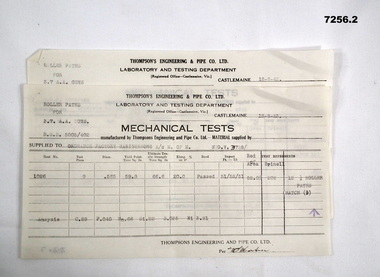
Document - MECHANICAL TEST RESULTS, Thompson's Engineering and Pipe Works, 1943
By referring to Cat No 7237.2 will bring up all items associated with Thompsons. Two sheets of paper from Thompson Engineering & Pipe Co. Ltd. To Ordnance Factory Maribyrnong Dated 18/8/43. Signed off by (??) Martin. 1. Results for tests on roller paths for 3.7 AA Guns (Batch 15). 2. Results for tests on roller paths for 3.7AA guns (Batch 9). Signed off by (??) Martin.3.7"aa guns, ord factory maribyrnong, thompsons castlemaine -
 Warrnambool and District Historical Society Inc.
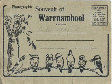
Document, Warrnambool Post Card, 1920s
Folding post cards were popular as tourist souvenir of visits to places in Australia throughout the 20th century. Many thousands of the same photographs were reproduced and the Warrnambool and District Historical Society has several examples of these photographs. These folding post cards are kept as examples of the souvenirs tourists bought in the early and mid 20th century and the photographs themselves give a good indication of what Warrrnamool and district looked like at the time. The photographs also indicate what were considered at the time to be tourist spots worth a visit and a photo. These are folding post cards with scenes of Warrnambool. One has a kangaroo and a bush landscape on the front cover and one has seven kookaburras and a gum tree on the cover. There are 15 of the same black and white photographs in each (taken about the 1920s). The covers are buff-coloured with a space on the front cover to write and address and affix a stamp. Front Cover – Photographic Souvenir of Warrnambool, Victoria On one (VC000803.2) – in pencil – ‘late 1920s’ and on back cover on affixed sheet, ‘ from Horsham H.S., 17.3.96’ warrnambool, 1920 warrnambool -
 Bendigo Military Museum
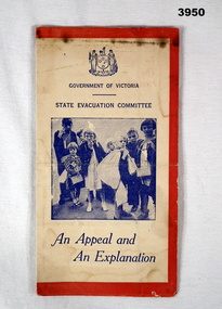
Document - DOCUMENT, EVACUATION, Possibly WW2
Coloured document, red / white / blue. Document folds out 4 times. Front shows a group of children with hand luggage. Details the evacuation procedure for all school children from aged between 6 - 15 years & mother or guardian. The document is for householders who may be implicated in this procedure during the war.“GOVERNMENT OF VICTORIA STATE EVACUATION COMMITTEE” “An Appeal and An Explanation”document, evacuation, families -
 Geelong RSL Sub Branch
Medals - 2180 J C Martin MM, Early 20th Century
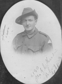
2180 Pte J C Martin MM was a member of the AIF and served during WW1 with 8 BN.These are the original Medals of 2180 Pte J C Martin MM who served with the AIF during WW1. On a wooden board is a black and white (oval shape) photograph of 2180 Pte J C Martin MM, 1914/15 Star, British War Medal and Victory Medal. Pte J C Martin MM was awarded a Military Medal for Bravery in the Field on 12 July 1918. Unfortunately the Military Medal is not with this collection.On the photograph written - 2180 Pte J C Martin, B Coy. On each medal - 2180 Pte J C Martin. 8/BN AIF. ww1 8 bn aif, 2180 pte j c martin mm -
 Federation University Historical Collection
Equipment - Scientific Instrument, Controlled Reader (Film Strip Reader)
A projector designed to display text from a specifically prepared roll-film onto a screen. The indexing frequency of the text lines is variable between 15 x 130 lines per minute. Fan cooled motor. Outer surfaces in grey hammered finish. In grey-finish storage box with removable top half. Nameplate, work speed table Serial No P130256 Model V-45-Pscientific instruments, projector, film strip projector, controlled reader -
Glenelg Shire Council Cultural Collection
Administrative record - Administrative Record - Performance Notes 'Remembering The Dead - Stories From The Grave', 2009