Showing 4028 items
matching hill's house
-
 Kew Historical Society Inc
Journal, Kewriosity : August 1989
Cricket with a difference [Kooyong Cricket Club, St Paul's School] / p1. No election for Kew / p1. Dates for August / p2. Changes to baby capsule loan scheme / p2. Council seeks comments on Area 7 Traffic Plan [Studley Park] / p2. Council to monitor Government policy on Kew Cottages Plan [deinstitutionalisation] / p3. Walpole Hill parking / p3. Fire and incinerator by-law under review / p3. Notices / p4. Local office gives tenants information [Inner Eastern Housing and Tenants' Information Service] / p4. New two-year-old session of occasional care [Kew Occasional Care Centre] / p4. Help for people with head injuries / p4. Free advice to home and business owners [Heritage Advisory Service] / p4. Images of Melbourne on local view [Ian Napier, Raya Gallery] / p5. "Sharps" Disposal Scheme planned for Kew / p5. Flowers from Friends of Bodalla / p5. Kew Community House / p6. Write about life / p6. Council supports free public libraries / p6. Senior Citizens' Week 1990 / p7. Extra school crossing supervisors for Kew / p7. Give blood for life / p7. Council may vaccinate "staff at risk" [Hepatitis B] / p7. Asbestos scheduled for removal from Council Offices / p7. Neighbourhood Watch / p8. Greenfingers change venue [Kew Garden Club] / p8. New production of The Lilac Domino [Viola Music Society] / p8. Why not croquet? [Kew Croquet Club] / p8. Footy News [Kew Football Club] / p8. Greenlink Kew / p8.Kewriosity was a local newsletter combining Kew Council and community news. It was published between November 1983 and June 1994, replacing an earlier Kewriosity [broad] Sheet (1979-84). In producing Kewriosity, Council aimed to provide a range of interesting and informative articles covering its deliberations and decision making, together with items of general interest and importance to the Kew community and information not generally available through daily media outlets.non-fictionCricket with a difference [Kooyong Cricket Club, St Paul's School] / p1. No election for Kew / p1. Dates for August / p2. Changes to baby capsule loan scheme / p2. Council seeks comments on Area 7 Traffic Plan [Studley Park] / p2. Council to monitor Government policy on Kew Cottages Plan [deinstitutionalisation] / p3. Walpole Hill parking / p3. Fire and incinerator by-law under review / p3. Notices / p4. Local office gives tenants information [Inner Eastern Housing and Tenants' Information Service] / p4. New two-year-old session of occasional care [Kew Occasional Care Centre] / p4. Help for people with head injuries / p4. Free advice to home and business owners [Heritage Advisory Service] / p4. Images of Melbourne on local view [Ian Napier, Raya Gallery] / p5. "Sharps" Disposal Scheme planned for Kew / p5. Flowers from Friends of Bodalla / p5. Kew Community House / p6. Write about life / p6. Council supports free public libraries / p6. Senior Citizens' Week 1990 / p7. Extra school crossing supervisors for Kew / p7. Give blood for life / p7. Council may vaccinate "staff at risk" [Hepatitis B] / p7. Asbestos scheduled for removal from Council Offices / p7. Neighbourhood Watch / p8. Greenfingers change venue [Kew Garden Club] / p8. New production of The Lilac Domino [Viola Music Society] / p8. Why not croquet? [Kew Croquet Club] / p8. Footy News [Kew Football Club] / p8. Greenlink Kew / p8. publications -- city of kew (vic.), kewriosity, council newsletters, community newsletters -
Kew Historical Society Inc
Journal, Kewriosity : October 1985
Children's Week 1985 / p1. Liquor Control Commission decides on hotels [Harp of Erin; Prospect Hill Hotel] / p1&4. Dates for October / p2. [Community] Notices / p2. Update: Notes from Council: Restructuring - How will it affect Kew? / Cr Phyllis Hore [Mayor of Kew] p3. Traffic management / p3. In Brief: [The latest of Safeway; No approval for Child Care Centre site; Congratulations STRIDE; Women's cricket in Kew; Budget time; Feel free to donate a tree] / p4. Thank you! [illustrators] / p4. Ode to the pedestrian [poem] / Warwick Hastie p4. Rectime [Recreation; Kew Recreation Centre] / p5. The Penguin Club / p5. The play's the thing! [Toorak Players] / p5. Kew Community House [English classes for migrants] / p5. Youth Page: [Are you a DAG in Kew? - survey; Competition - Why is Kew BORING?; How did you go? / p6. Those halcyon days - Part 3 [social history] / Bill Stent p7. Kew loses a very generous man [Brian White] / p7. Ke Little Athletics / p7. Kew Rotaract / p8. This Kewriosity is brought to you by the boys of the Fourth Kew Scout Group / p8. Letters - Motel permit challenges / JM Rao / p8. Cr Saunders responds [Studley Park Road] / Robin Saunders p8.Kewriosity was a local newsletter combining Kew Council and community news. It was published between November 1983 and June 1994, replacing an earlier Kewriosity [broad] Sheet (1979-84). In producing Kewriosity, Council aimed to provide a range of interesting and informative articles covering its deliberations and decision making, together with items of general interest and importance to the Kew community and information not generally available through daily media outlets.non-fictionChildren's Week 1985 / p1. Liquor Control Commission decides on hotels [Harp of Erin; Prospect Hill Hotel] / p1&4. Dates for October / p2. [Community] Notices / p2. Update: Notes from Council: Restructuring - How will it affect Kew? / Cr Phyllis Hore [Mayor of Kew] p3. Traffic management / p3. In Brief: [The latest of Safeway; No approval for Child Care Centre site; Congratulations STRIDE; Women's cricket in Kew; Budget time; Feel free to donate a tree] / p4. Thank you! [illustrators] / p4. Ode to the pedestrian [poem] / Warwick Hastie p4. Rectime [Recreation; Kew Recreation Centre] / p5. The Penguin Club / p5. The play's the thing! [Toorak Players] / p5. Kew Community House [English classes for migrants] / p5. Youth Page: [Are you a DAG in Kew? - survey; Competition - Why is Kew BORING?; How did you go? / p6. Those halcyon days - Part 3 [social history] / Bill Stent p7. Kew loses a very generous man [Brian White] / p7. Ke Little Athletics / p7. Kew Rotaract / p8. This Kewriosity is brought to you by the boys of the Fourth Kew Scout Group / p8. Letters - Motel permit challenges / JM Rao / p8. Cr Saunders responds [Studley Park Road] / Robin Saunders p8. publications -- city of kew (vic.), kewriosity, council newsletters, community newsletters -
Kew Historical Society Inc
Journal, Kewriosity : July 1985
Kew Safeway expansion / p1. Community Notes [Clubs and Societies; General; Politics; Religious notices; Support Groups] / p2&16.Update: Notes from Council - Kew's parklands / Cr Robin Saunders, Mayor [of Kew] p3. In Brief [We are desperate - Kew Community Bus; No Vacancy - Davis Street Kindergarten; Kew contributes to Housing Council; This is an emergency - Meals on Wheels; Elections coming up; Assistance grants distributed; Fence trees soon] / p4. Traffic Management / p4. Concern for residents top priority in hotels dispute [Prospect Hill Hotel; Harp of Erin/ p5. Friends of Kew Library take action {Library relocation; Kew Historical Society; Toy Library] / p5. Baby safety bassinet loan scheme off and running / p5. Neighbourhood Watch - Keeping an eye open [Operation identification / Neighbourhood Watch works; Home security meeting] / p6. Kew Community House - What we are about / p6. Kew Heritage Survey - Information exchange meeting / p7. Heritage assets [Houses and other buildings; Other structures and works; Streetscapes; Sites; Natural areas and open space; Panoramas, vistas or views] / p8. Nomination of potential heritage asset [survey form] / p9.Further comment [Line drawing - 'Ivy Grange'] / p10. Youth Page - Youth Theatre a-goer; Apology / p11. Some ways to avoid burning [incinerators] / p12. Learn how to paint on silk / p12. The ABC of the CAB [Citizens Advice Bureau] / p13. High times at Kew's Cemetery / Ellen Coates [social history] p14. Archer of the year 1984/85 [Gerry Hevey, Kew City Bowmen] / p15. Library News / p15. This Kewriosity is being delivered to you by - Kew Women's Hockey Club / p15. Letters - Small Business too pricey /Mrs J Chambers; Theft and vandalism hits Bowmen / Jim Bagnelli; A case of discrimination / Kathy Don.Kewriosity was a local newsletter combining Kew Council and community news. It was published between November 1983 and June 1994, replacing an earlier Kewriosity [broad] Sheet (1979-84). In producing Kewriosity, Council aimed to provide a range of interesting and informative articles covering its deliberations and decision making, together with items of general interest and importance to the Kew community and information not generally available through daily media outlets.non-fictionKew Safeway expansion / p1. Community Notes [Clubs and Societies; General; Politics; Religious notices; Support Groups] / p2&16.Update: Notes from Council - Kew's parklands / Cr Robin Saunders, Mayor [of Kew] p3. In Brief [We are desperate - Kew Community Bus; No Vacancy - Davis Street Kindergarten; Kew contributes to Housing Council; This is an emergency - Meals on Wheels; Elections coming up; Assistance grants distributed; Fence trees soon] / p4. Traffic Management / p4. Concern for residents top priority in hotels dispute [Prospect Hill Hotel; Harp of Erin/ p5. Friends of Kew Library take action {Library relocation; Kew Historical Society; Toy Library] / p5. Baby safety bassinet loan scheme off and running / p5. Neighbourhood Watch - Keeping an eye open [Operation identification / Neighbourhood Watch works; Home security meeting] / p6. Kew Community House - What we are about / p6. Kew Heritage Survey - Information exchange meeting / p7. Heritage assets [Houses and other buildings; Other structures and works; Streetscapes; Sites; Natural areas and open space; Panoramas, vistas or views] / p8. Nomination of potential heritage asset [survey form] / p9.Further comment [Line drawing - 'Ivy Grange'] / p10. Youth Page - Youth Theatre a-goer; Apology / p11. Some ways to avoid burning [incinerators] / p12. Learn how to paint on silk / p12. The ABC of the CAB [Citizens Advice Bureau] / p13. High times at Kew's Cemetery / Ellen Coates [social history] p14. Archer of the year 1984/85 [Gerry Hevey, Kew City Bowmen] / p15. Library News / p15. This Kewriosity is being delivered to you by - Kew Women's Hockey Club / p15. Letters - Small Business too pricey /Mrs J Chambers; Theft and vandalism hits Bowmen / Jim Bagnelli; A case of discrimination / Kathy Don. publications -- city of kew (vic.), kewriosity, council newsletters, community newsletters -
 Kew Historical Society Inc
Photograph - Yarra in Flood, 1934
Flooding of the Yarra Valley, including that section of the Yarra bordering Kew and Kew East in the north and west of the municipality, was a regular occurrence. Extreme flood events of the Yarra River are recorded to have occurred in 1891, 1901, 1916, 1923 and 1934. The Municipality of Kew's response to these floods was to enact planning decisions restricting residential development in flood prone areas following the floods of 1916, 1921 and 1934. While floods continued after the development of the Upper Yarra Reservoir (construction 1948-57), the regularity and extent of these inundations diminished.Black and white print positive. 1934 floods of the Yarra Valley. Location Fairfield looking towards wooded hillside. Houses floating in river.Reverse: "From Fairfield Park (11936?) back towards hill (Wurundjeri Spur?)"floods -- 1934, yarra valley, yarra river, fairfield park -
 Kew Historical Society Inc
Photograph - Battery Hill Fort at Port Fairy, c.1926
Henry Beater Christian (1886-1962) , was a descendant of one of the earliest settler families in Kew. Employed at the Kew Asylum as a 'public servant', he was a skilled amateur photographer, photographing numerous scenes in Kew and on his travels around Victoria. The majority of his photographs date from 1916 to 1929. His finest photographs are housed in two photograph albums. Digital copy of a photograph from page 23 of the 47-page photograph album containing 261 gelatinous silver images, loaned by Diane Washfold with permission given to digitise and hold a copy in our collection. In the 1920s, the photographer travelled throughout Victoria, including on the west coast from Port Campbell to Port Fairy. Trips were presumably made by train and by foot. Lynda Tieman and her team at the Port Fairy Historical Society have tentatively identified a number of Henry Christian's photographs of Port Fairy, of which this is one. A man is photographed (possibly Henry Christian) standing within the Battery Hill Fort at Port Fairy.henry beater christian (1886-1962), landscape photography, christian-washfold collection, photograph albums, port fairy (vic.), battery hill fort -
![Architectural Moulding: Fragment of plaster and cement cornice from Southesk [Ordsall]](/media/collectors/550653872162f11fb04854aa/items/66b185bc235bc2950ebe8440/item-media/66b197c7235bc2950ec38cc7/item-fit-380x285.jpg) Kew Historical Society Inc
Kew Historical Society IncArchitectural Moulding, Fragment of plaster and cement cornice from Southesk [Ordsall], 1870-80
'Ordsall', renamed 'Southesk' in the 20th century was built for John Halfey in or before 1865. The house was rebuilt in the 1870s to designs by architect Michael Hennessy. In 1882 the house was redecorated by the firm of Cullis Hill & Co., who hired the artists 'Mr Vandenbrandt' and 'Signor Rizzi" to paint the ceilings of the ballroom and the drawingroom. The artistic triumph was described in detail in The Argus, 30 October, 1882. In 1947, Southesk was purchased by the Kew City Council. For 23 years it was used as a meeting place for community groups. The house was then demolished in 1970 to make way for a new Town Hall.Rare, and possible unique fragment of a plaster cornice from one of the most architecturally distinctive houses in Kew, demolished 1970.Section of plaster cornice removed from Southesk on the corner of Charles Street and Cotham Road, Kew, when it was demolished in 1970 by the City of Kew. The cornice has a narrow layer of previously coloured plaster which is now overlaid with a grey distemper. The foundation of the cornice is moulded cement. Remnant flowers moulded in the central band of the cornice include a rose and a sunflower. The plaster decoration was probably located in the entrance hall, dining room or ballroom, all of which were created in the 1870s by Michael Hennessy and decorated by the firm of art decorators, Cullis Hill & Co in 1882.Nilordsall, south esk, cullis hill, plasterwork, cornices, victorian interiors -
![Township of Lorne, and Loutitt Bay / [by] Nicholas Caire, circa 1876](/media/collectors/550653872162f11fb04854aa/items/5783458ad0cdd1176c6f0c78/item-media/578345eed0cdd1176c6f852b/item-fit-380x285.jpg) Kew Historical Society Inc
Kew Historical Society IncPhotograph, Anglo-Australasian Photographic Company, Township of Lorne, and Loutitt Bay, c. 1876
Nicholas Caire was born on Guernsey in the Channel Islands in 1837. He arrived in Adelaide with his parents in about 1860. In 1867, following photographic journeys in Gippsland, he opened a studio in Adelaide. From 1870 to 1876 he lived and worked in Talbot in Central Victoria. In 1876 he purchased T. F. Chuck's studios in the Royal Arcade Melbourne. In 1885, following the introduction of dry plate photography, he began a series of landscape series, which were commercially successful. As a photographer, he travelled extensively through Victoria, photographing places few of his contemporaries had previously seen. He died in 1918. Reference: Jack Cato, 'Caire, Nicholas John (1837–1918)', Australian Dictionary of Biography.An original, rare photograph from the series 'Views of Victoria: General Series' by the photographer, Nicholas Caire (1837-1918). The 60 photographs that comprise the series were issued c. 1876 and reinforced a neo-Romantic view of the Australian landscape to which a growing nationalist movement would respond. Nicholas Caire was active as a photographer in Australia from 1858 until his death in 1918. His vision of the Australian bush and pioneer life had a counterpart in the works of Henry Lawson and other nationalist poets, authors and painters.‘Township of Lorne, and Loutitt Bay’ : Views of Victoria (General Series) No.60 : Albumen silver photograph | Photo on card with Title and Description on reverse | Mounted 24 x 30 cm; Photo 12 x 17 cm.On Reverse: ‘Loutitt Bay is fast becoming one of the most fashionable Watering-places in Victoria, partly from its easy access by Rail, combined with the magnificent scenery to be found in the Cape Otway Ranges, and the very moderate charges of the houses of accommodation. The large house near the foreground is that of Mr. Mountjoy, which is a Restaurant. Duncan’s Hotel can be seen in the distance, on the brow of the hill.’nicholas caire (1837-1918), lorne (vic), duncan's hotel, loutitt bay, landscape photography - victoria -
 Kew Historical Society Inc
Plan - Subdivision Plan, Goldthorns House Estate, 1940
Pru Sanderson, in her groundbreaking ‘City of Kew Urban Conservation Study : Volume 2 - Development History’ (1988), summarised the periods of urban development and subdivisions of land in Kew. The periods that she identified included 1845-1880, 1880-1893, 1893-1921, 1921-1933, 1933-1943, and Post-War Development. These periods were selected as they represented periods of rapid growth or decline in urban development. An obvious starting point for Sanderson’s groupings involved population growth and the associated economic cycles. These cycles also highlighted urban expansion onto land that was predominantly rural, although in other cases it represented the decline and breakup of large estates. A number of the plans in the Kew Historical Society’s collection can also be found in other collections, such as those of the State Library of Victoria and the Boroondara Library Service. A number are however unique to the collection.The Kew Historical Society collection includes almost 100 subdivision plans pertaining to suburbs of the City of Melbourne. Most of these are of Kew, Kew East or Studley Park, although a smaller number are plans of Camberwell, Deepdene, Balwyn and Hawthorn. It is believed that the majority of the plans were gifted to the Society by persons connected with the real estate firm - J. R. Mathers and McMillan, 136 Cotham Road, Kew. The Plans in the collection are rarely in pristine form, being working plans on which the agent would write notes and record lots sold and the prices of these. The subdivision plans are historically significant examples of the growth of urban Melbourne from the beginning of the 20th Century up until the 1980s. A number of the plans are double-sided and often include a photograph on the reverse. A number of the latter are by noted photographers such as J.E. Barnes.The first subdivision of Goldthorns created the Goldthorns Hill Estate. Following that subdivision, seven additional lots were offered between Normanby Road, Argyle Road and Lady Loch’s Drive on the proviso that the estate, including Goldthorns was not sold as a single lot. The subdivision plan advises that the lots are situated in one of the most charming and popular residential areas in Kew and is surrounded by modern homes. Typically, the subdivision plan proposes the advantage of its proximity to Cotham Road and the tram to Collins Street. Because of the elevation of Goldthorns, much is made of the ‘bright, sunny and extensive outlook to the Northern Ranges’ and that it overlooks the Yarra Valley. One of the more interesting aspects of the plan is that it shows the outline of Goldthorns in the mid to late 1920s. Its profile today remains virtually the same."Goldthorns" House Estate at topsubdivision plans - kew, goldthorns house estate -
 Kew Historical Society Inc
Plan - Subdivision Plan, Wimba Estate, Kew, c.1925-c.1929, ca. 1925-ca. 1929
Pru Sanderson, in her groundbreaking ‘City of Kew Urban Conservation Study : Volume 2 - Development History’ (1988), summarised the periods of urban development and subdivisions of land in Kew. The periods that she identified included 1845-1880, 1880-1893, 1893-1921, 1921-1933, 1933-1943, and Post-War Development. These periods were selected as they represented periods of rapid growth or decline in urban development. An obvious starting point for Sanderson’s groupings involved population growth and the associated economic cycles. These cycles also highlighted urban expansion onto land that was predominantly rural, although in other cases it represented the decline and breakup of large estates. A number of the plans in the Kew Historical Society’s collection can also be found in other collections, such as those of the State Library of Victoria and the Boroondara Library Service. A number are however unique to the collection.Subdivision plans are historically important documents used as evidence of the growth of suburbs in Australia. They frequently provide information about when the land was sold on which a built structure was subsequently constructed as well as evidence relating to surveyors and real estate and financial agents. The numerous subdivision plans in the Kew Historical Society's collection represent working documents, ranging from the initial sketches made in planning a subdivision to printed plans on which auctioneers or agents listed the prices for which individual lots were sold. In a number of cases, the reverse of a subdivision plan in the collection includes a photograph of a house that was also for sale by the agent. These photographs provide significant heritage information relating house design and decoration, fencing and household gardens.In 1925, the City of Kew called for tenders for the construction of Wimba Avenue, Cadow Street and Lalla Street. Subsequent advertisements for the sale of land in Wimba Avenue continued from 1926 to 1929. The 18 lots (and a further five allotments on the eastern side of the street) offered for sale were unofficially described in the subdivision plan as the ‘Wimba Estate’. These lots began in Park Hill Road and extended almost to Cotham Road. The subdivision took its name from the house ‘Wimba’ in Cotham Road, which may have formed the southern boundary of the subdivision. (Wimba, at 235 Cotham Road was constructed between 1862-70). The Plan highlights the proximity and advantage of ‘electric’ trams in Cotham and Glenferrie Roads, and the Kew and Glenferrie Railway Stations. An oddity in the Plan is the reference to the electric tram terminus at Burke Road, given that the tramline had already been extended to Mont Albert in 1916.wimba estate, subdivision plans - kew, parkhill road – kew (vic.), normanby road – kew (vic.), wimba avenue – kew (vic.) -
 Kew Historical Society Inc
Plan - Subdivision Plan, Mont Victor Hill Estate, 1936
Pru Sanderson, in her groundbreaking ‘City of Kew Urban Conservation Study : Volume 2 - Development History’ (1988), summarised the periods of urban development and subdivisions of land in Kew. The periods that she identified included 1845-1880, 1880-1893, 1893-1921, 1921-1933, 1933-1943, and Post-War Development. These periods were selected as they represented periods of rapid growth or decline in urban development. An obvious starting point for Sanderson’s groupings involved population growth and the associated economic cycles. These cycles also highlighted urban expansion onto land that was predominantly rural, although in other cases it represented the decline and breakup of large estates. A number of the plans in the Kew Historical Society’s collection can also be found in other collections, such as those of the State Library of Victoria and the Boroondara Library Service. A number are however unique to the collection.Subdivision plans are historically important documents used as evidence of the growth of suburbs in Australia. They frequently provide information about when the land was sold on which a built structure was subsequently constructed as well as evidence relating to surveyors and real estate and financial agents. The numerous subdivision plans in the Kew Historical Society's collection represent working documents, ranging from the initial sketches made in planning a subdivision to printed plans on which auctioneers or agents listed the prices for which individual lots were sold. In a number of cases, the reverse of a subdivision plan in the collection includes a photograph of a house that was also for sale by the agent. These photographs provide significant heritage information relating house design and decoration, fencing and household gardens.A preliminary plan for the Mont Victor Hill subdivision of 1936 which included 23 allotments bordering the Rimington Nursery in Mont Victor Road. The subdivision created allotments in Victor Avenue, Heather Grove and Burke Road. Bisecting the Estate and clearly marked on the plan is the Railway Reserve which at this stage was all that remained of the Outer Circle Railway. The auctioneers note on the plan that the subdivision was made possible by the order of Messrs S. H. Bennet & H. Wright, the executors of the Wills of S. Bennett & E. Foreman.mont victor hill estate, subdivision plans - kew -
 Kew Historical Society Inc
Plan - Subdivision Plan, 10 Fine Villa Sites: Ermington Estate, Kew Heights, ca. 1917
Pru Sanderson, in her groundbreaking ‘City of Kew Urban Conservation Study : Volume 2 - Development History’ (1988), summarised the periods of urban development and subdivisions of land in Kew. The periods that she identified included 1845-1880, 1880-1893, 1893-1921, 1921-1933, 1933-1943, and Post-War Development. These periods were selected as they represented periods of rapid growth or decline in urban development. An obvious starting point for Sanderson’s groupings involved population growth and the associated economic cycles. These cycles also highlighted urban expansion onto land that was predominantly rural, although in other cases it represented the decline and breakup of large estates. A number of the plans in the Kew Historical Society’s collection can also be found in other collections, such as those of the State Library of Victoria and the Boroondara Library Service. A number are however unique to the collection.The Kew Historical Society collection includes almost 100 subdivision plans pertaining to suburbs of the City of Melbourne. Most of these are of Kew, Kew East or Studley Park, although a smaller number are plans of Camberwell, Deepdene, Balwyn and Hawthorn. It is believed that the majority of the plans were gifted to the Society by persons connected with the real estate firm - J. R. Mathers and McMillan, 136 Cotham Road, Kew. The Plans in the collection are rarely in pristine form, being working plans on which the agent would write notes and record lots sold and the prices of these. The subdivision plans are historically significant examples of the growth of urban Melbourne from the beginning of the 20th Century up until the 1980s. A number of the plans are double-sided and often include a photograph on the reverse. A number of the latter are by noted photographers such as J.E. Barnes.In November 1917, the Ermington Estate was advertised as an ‘Executor’s Sale’. It included the 10-roomed villa residence, ‘Ermington’, home of the late Mrs. Lorimer, and 10 ‘magnificent allotments’. The plan in the Kew Historical Society Collection is a little more specific. Ermington is described as having 9 Rooms &c. and there are 11 lots shown on the west side of Hillcrest Avenue. In the plan, the latter is named as ‘Hill Crest Avenue’. The plan indicates that the subdivision was based on the surveying work of Johnson & Tait. Opposite Ermington, the existing house ‘Parkhill’ is identified. A faded stamp on two parts of the plan indicates that it was in the possession of Jas. [R.] Mathers, Financial Agent, [136] Cotham Road, Kew.subdivision plans - kew, ermington heights estate - kew heights -
 Kew Historical Society Inc
Plan - Subdivision Plan, Goldthorns Hill Estate, 1925
Pru Sanderson, in her groundbreaking ‘City of Kew Urban Conservation Study : Volume 2 - Development History’ (1988), summarised the periods of urban development and subdivisions of land in Kew. The periods that she identified included 1845-1880, 1880-1893, 1893-1921, 1921-1933, 1933-1943, and Post-War Development. These periods were selected as they represented periods of rapid growth or decline in urban development. An obvious starting point for Sanderson’s groupings involved population growth and the associated economic cycles. These cycles also highlighted urban expansion onto land that was predominantly rural, although in other cases it represented the decline and breakup of large estates. A number of the plans in the Kew Historical Society’s collection can also be found in other collections, such as those of the State Library of Victoria and the Boroondara Library Service. A number are however unique to the collection.The Kew Historical Society collection includes almost 100 subdivision plans pertaining to suburbs of the City of Melbourne. Most of these are of Kew, Kew East or Studley Park, although a smaller number are plans of Camberwell, Deepdene, Balwyn and Hawthorn. It is believed that the majority of the plans were gifted to the Society by persons connected with the real estate firm - J. R. Mathers and McMillan, 136 Cotham Road, Kew. The Plans in the collection are rarely in pristine form, being working plans on which the agent would write notes and record lots sold and the prices of these. The subdivision plans are historically significant examples of the growth of urban Melbourne from the beginning of the 20th Century up until the 1980s. A number of the plans are double-sided and often include a photograph on the reverse. The Goldthorns Hill Estate subdivision was first put up for auction in 1925. The subdivision took its name from the mansion ‘Goldthorns’, shown on the plan between Normanby Road and Lady Loch’s Drive. Contemporary advertisements describe forty-three home sites being fro sale, yet only forty-one appear on this plan. Buyers were lured by the prospect of the proposed extension of the Burke Road tram to High Street. Discerning buyers were advised that only one house could be built per allotment, and that houses needed to be constructed of brick, stone or concrete and have a slate or tiled roof.goldthorns avenue -- kew east (vic.), lady loch drive -- kew east (vic.), argyle road -- kew east (vic.), lady brassey drive -- kew east (vic.), campbell street -- kew east (vic.), goldthorns -- kew (vic.), subdivisions -- kew east (viv.), goldthorns hill estate -
 Kew Historical Society Inc
Plan - Subdivision Plan, Jas R Mathers Son & McMillan, Clifton Estate, Kew, c. 1916
Pru Sanderson, in her groundbreaking ‘City of Kew Urban Conservation Study : Volume 2 - Development History’ (1988), summarised the periods of urban development and subdivisions of land in Kew. The periods that she identified included 1845-1880, 1880-1893, 1893-1921, 1921-1933, 1933-1943, and Post-War Development. These periods were selected as they represented periods of rapid growth or decline in urban development. An obvious starting point for Sanderson’s groupings involved population growth and the associated economic cycles. These cycles also highlighted urban expansion onto land that was predominantly rural, although in other cases it represented the decline and breakup of large estates. A number of the plans in the Kew Historical Society’s collection can also be found in other collections, such as those of the State Library of Victoria and the Boroondara Library Service. A number are however unique to the collection.The Kew Historical Society collection includes almost 100 subdivision plans pertaining to suburbs of the City of Melbourne. Most of these are of Kew, Kew East or Studley Park, although a smaller number are plans of Camberwell, Deepdene, Balwyn and Hawthorn. It is believed that the majority of the plans were gifted to the Society by persons connected with the real estate firm - J. R. Mathers and McMillan, 136 Cotham Road, Kew. The Plans in the collection are rarely in pristine form, being working plans on which the agent would write notes and record lots sold and the prices of these. The subdivision plans are historically significant examples of the growth of urban Melbourne from the beginning of the 20th Century up until the 1980s. A number of the plans are double-sided and often include a photograph on the reverse. A number of the latter are by noted photographers such as J.E. Barnes.The Clifton Estate was an ambitious subdivision. It included 61 allotments bordering Cotham and Park Hill Roads, and Florence and Adeney Avenues. It is difficult to ascertain the exact year when the ‘Clifton Estate’ was surveyed, subdivided and first auctioned. The uncertainty may be due to allotments being released during the First World War. The subdivision took its name from the house ‘Clifton’ (lot 5) on the corner of Adeney Avenue and Cotham Road. The outline of Clifton (since demolished) and the extent of its land following the subdivision are represented on the plan. The auctioneers have also shown ‘Maryfield’ and ‘Wimba’, the neighbouring properties in Cotham Road, on the plan."B"subdivision plans - kew, clifton estate, cotham road, adeney avenue, florence avenue, park hill road -
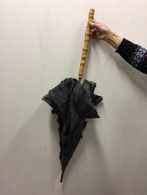 Kew Historical Society Inc
Accessory - Silk, Metal & Cane Parasol, c. 1899-1902
An item forming part of a collection of costumes, photographs and documents relating to the Weir family who owned and lived in the mansion originally named Illapa, 84 Princess Street, Kew, from 1918 to 1950. [The house is now incorporated by ‘Rylands’.] This historically significant collection includes items relating to both George Weir (1866-1937) and his wife Edith Mary Weir (1867-1948). George Weir, a person of national significance, was general manager of North Broken Hill Mine between 1903 and 1926. The collection includes a number of his patents. He married his wife, Edith Butteridge, in Broken Hill in 1891. The collection includes a number of costumes owned and worn by Edith, including her wedding dress. These costumes date from the 1880s to the 1940s and include items of outstanding aesthetic value.This parasol is significant as it is part of 26-piece collection of women’s clothing owned by Edith Mary Weir (nee Betteridge), who was born in Clare, South Australia in 1867 and who died in Kew at the age of 81 in 1948. The costumes in the donation date from the 1880s to the 1940s and constitute outstanding examples of dressmaker’s skills from each of these decades. The collection includes day dresses, evening dresses, evening coats, capes, a parasol, and undergarments. As the wife of a mining engineer, and later mine manager, Edith Weir’s clothing has historic significance as examples of clothing worn by upper middle class Australian women in domestic circumstances and at social and civic events. The costumes in the collection represent the periods when Edith Weir lived in Broken Hill, New South Wales, and in Kew, Melbourne. The garments in the Weir Collection were donated to the Kew Historical Society by the granddaughter of Edith Weir.Parasol - brown silk, pink lined with straight cane handle, owned by Edith Mary Weir (nee Betteridge) of Broken Hill, and later Princess Street, Kew. The style of the parasol, with overlapping outer 'scales' of heavy brown silk, would indicate that it was made in the late Victorian era.parasols, umbrellas, victorian fashion, weir collection -
 Kew Historical Society Inc
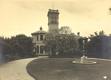
Photograph - 84 Princess Street (Kew), c. 1935
An item forming part of a collection of costumes, photographs and documents relating to the Weir family who lived in a mansion, originally named Illapa, at 84 Princess Street, Kew, from c.1917 to 1950. This historically significant collection includes items relating to both George Weir (1866-1937), his wife Edith Mary Weir (1867-1948) and their children. George Weir attained national prominence in the mining industry, becoming General Manager of the North Broken Hill Silver Mining Company in 1903 (later renamed North Broken Hill Mining Company 1905-12, and North Broken Hill Ltd 1912-1988), and subsequently President of the Mine Owners Association. He was to remain General Manager of North Broken Hill Ltd until his retirement in 1926.Sepia-toned photograph of 84 Princess Street, Kew during the occupation of the house by the Weir family during the years 1918-1950. The house and garden had formerly been named Illapa and then Parcnacilla. In 1950 the family sold the house to a religious order who renamed the house 'The Towers'. It now forms part of 'Rylands'.illapa -- 84 princess street -- kew (vic.), george weir, edith mary weir (nee betteridge), weir collection -
 Kew Historical Society Inc
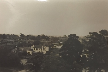
Photograph - Studley Park (Kew), c.1949
An item forming part of a collection of costumes, photographs and documents relating to the Weir family who lived in a mansion, originally named Illapa, at 84 Princess Street, Kew, from c.1917 to 1950. This historically significant collection includes items relating to both George Weir (1866-1937), his wife Edith Mary Weir (1867-1948) and their children. George Weir attained national prominence in the mining industry, becoming General Manager of the North Broken Hill Silver Mining Company in 1903 (later renamed North Broken Hill Mining Company 1905-12, and North Broken Hill Ltd 1912-1988), and subsequently President of the Mine Owners Association. He was to remain General Manager of North Broken Hill Ltd until his retirement in 1926.Small black and white photograph of a panoramic view from the tower of 84 Princess Street, Kew during the occupation of the house by the Weir family during the years 1918-1950. The house and garden had formerly been named Illapa and then Parcnacilla. In 1950 the family sold the house to a religious order who renamed the house 'The Towers'. It now forms part of 'Rylands'.illapa -- 84 princess street -- kew (vic.), aerial photographs -- kew (vic.), studley park (kew) -1930s -
 Kew Historical Society Inc
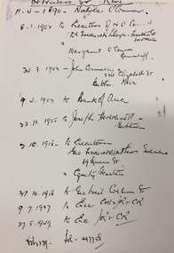
Document - Manuscript [copy], List of Owners, 84 Princess Street (Kew), 1890-1949, c.1949
An item forming part of a collection of costumes, photographs and documents relating to the Weir family who lived in a mansion, originally named Illapa, at 84 Princess Street, Kew, from c.1917 to 1950. This historically significant collection includes items relating to both George Weir (1866-1937), his wife Edith Mary Weir (1867-1948) and their children. George Weir attained national prominence in the mining industry, becoming General Manager of the North Broken Hill Silver Mining Company in 1903 (later renamed North Broken Hill Mining Company 1905-12, and North Broken Hill Ltd 1912-1988), and subsequently President of the Mine Owners Association. He was to remain General Manager of North Broken Hill Ltd until his retirement in 1926.Handwritten register of owners of 84 Princes Street, Kew. Built for John Hedderwick, the house was variously known throughout its history as Illapa and Parcnacilla. The list, compiled for the Weir family before they sold the house in 1950, includes the names of owners between 1890 and 1949.84 princess street -- kew (vic.), george weir -
 Kew Historical Society Inc
Postcard, R McGeehan, The Effect of Storm. Train Passing Through Flood Waters, South Yarra, 25-1-07, 1907
SHARP DOWNPOUR. ONE INCH IN 45 MINUTES. SOUTHERN SUBURBS DELUGED. TRAIN STOPPED AT SOUTH YARRA. One of the sudden downpours of rain which occasionally fall in Melbourne occurred yesterday afternoon, when nearly an inch of rain fell in the course of three quarters of an hour, and caused a flood for an hour or two in certain localities. During the early part of the day, the sky had been clouded over, but there was nothing to indicate a storm of such intensity as that which followed. At about half-past 1 o'clock residents of South Yarra, South Melbourne, Prahran, and St. Kilda noticed a few drops of rain. Still, it appeared unlikely that there would be anything exceptional, until with startling suddenness at about 10 minutes to 1 o'clock, one of the heaviest downpours within the memory of residents burst upon those suburbs. A strange feature of the storm was that it was practically confined to an area of about three miles square. The city was but little affected, though at a spot as close as the Observatory 86 points of rain were recorded in three-quarters of an hour. Thunder and lightning accompanied the downpour, which was cyclonic in character, the rain driving heavily from all points of the compass as the cyclone passed. It was in South Yarra and Prahran that the rain fell heaviest. Within a few minutes after it commenced, the low-lying portions of Toorak-road and practically the whole length of Chapel-street were under water. The depression at the intersection of Toorak-road and Darling-street speedily filled to the dimensions of a small lake. Several shops were inundated, while the water from the higher levels rushed down like a mountain torrent, and in several in-stances swept through the rear of houses and shops, carrying furniture in a floating mass against the further walls. In one case a footbridge was carried bodily away and dashed to pieces. Darling-street itself Great Davis-street, and other low-lying and flat thoroughfares in the vicinity became flooded from kerb to kerb, while on the other side of the railway-bridge the valley between Kensington-road and River-street became filled for some minutes to a depth of several feet. Meanwhile the waters from South Yarra hill, seeking a lower level, found it in the railway cutting, and the excavations from South Yarra station to Prahran on the one line, and to the Chapel-street bridge on the other, were converted into a couple of canals. At the platforms at South Yarra the water was two feet deep on the permanent way, and towards Hawksburn, at the sudden depression under Chapel-street bridge, it was at one time deep enough to cover a tall man's head. Into this swirling mass of water the 1:50 p.m. train from Oakleigh plunged on its way to Melbourne. The impact caused a mighty fountain of water to rise to a height of about 20 feet above the level of Chapel-street and send clouds of spray in all directions. Under the belief that a terrible explosion had occurred residents braved the rain and rushed to the spot, only to find that the train had been brought to a stand-still in the middle of what seemed to be a river. The water was so high that it had entered the fire-box from below, extinguishing the fires and cutting off the steam supply. In the meantime the officials at the South Yarra station had been preparing for emergencies. Inspectors were on duty at intervals along the line, and the moment the alarm was given an extra engine was backed carefully down and continued on to connect with the stranded train without losing its own power. There was a delay of about ten minutes in the service for an hour or two, but by 5 o'clock all the trains were running on time again, and the water had run off all but the spot beneath the Chapel-street bridge. Here the water remained about four feet deep until nightfall, and throughout the afternoon several hundreds of people including biograph operators and photographers, were gathered around watching each train pass through. Even with the water two feet lower, this was a work attended with considerable difficulty. Each train had to absolutely force its way through the weight of water, almost enveloped by the spray thrown up, and it was only just able to negotiate the "ford" by using every ounce of steam. ... The Argus, 26 January 1907, p19.The item forms part of the Laurie Bennett collection of thirty-six postcards and photographs of Kew and early Melbourne, donated to the Kew Historical Society in 1980. The postcards in the Bennett collection, like other images in the Society's holdings date from the 1890s to the present and comprehensively indicate points-of-view or scenes considered historically, aesthetically or socially significant in the period in which they were produced.Postcard depicting a flood at South Yarra Station in 1907. The title and photographer's name are identified on the front of the postcard. Donated by L. Bennett, 1980flood - south yarra, trains - melbourne, postcards, r mcgeehan - prahran -
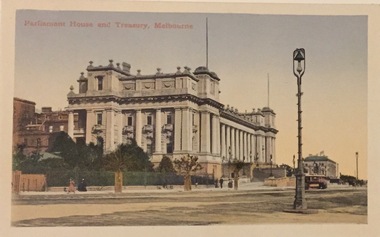 Kew Historical Society Inc
Postcard, Parliament House and Treasury, Melbourne, c.1907
Collection of thirty-nine postcards donated by Jillian Rigby which had been owned by her grandparents, George and Edith Weir, who from c.1917 lived at 84 Princess Street, Kew. The mostly 'mint' postcards were purchased in Victoria and while travelling overseas. The sole dated postcard is dated from 1929. The postcards are numbered sequentially from 2017.0058.01-39. The remainder of the collection donated by Jill Rigby which was once owned by the Weirs of Broken Hill and Kew consist of costumes, costume accessories, photographs, and documents.The postcards in the Weir collection, especially those purchased on a trip or trips to the mother country, i.e. United Kingdom, represent a representative sample of sites that were considered significant to those Australians undertaking a reverse grand tour by member of the erstwhile colonies. Those postcards which are early views of Melbourne must have been produced commercially for some decades from the early part of the 20th century.Parliament House and Treasury, Spring Street, Melbourne. Coloured postcard of early Melbourne. Weir collection."Parliament House and Treasury, Melbourne"postcards, george and edith weir, parliament house - melbourne, treasury building - melbourne, weir collection -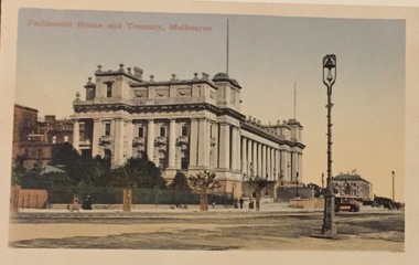
 Kew Historical Society Inc
Plan, Melbourne & Metropolitan Board of Works : Borough of Kew : Detail Plan No.1297, 1904
The Melbourne and Metropolitan Board of Works (MMBW) plans were produced from the 1890s to the 1950s. They were crucial to the design and development of Melbourne's sewerage and drainage system. The plans, at a scale of 40 feet to 1 inch (1:480), provide a detailed historical record of Melbourne streetscapes and environmental features. Each plan covers one or two street blocks (roughly six streets), showing details of buildings, including garden layouts and ownership boundaries, and features such as laneways, drains, bridges, parks, municipal boundaries and other prominent landmarks as they existed at the time each plan was produced. (Source: State Library of Victoria)This plan forms part of a large group of MMBW plans and maps that was donated to the Society by the Mr Poulter, City Engineer of the City of Kew in 1989. Within this collection, thirty-five hand-coloured plans, backed with linen, are of statewide significance as they include annotations that provide details of construction materials used in buildings in the first decade of the 20th century as well as additional information about land ownership and usage. The copies in the Public Record Office Victoria and the State Library of Victoria are monochrome versions which do not denote building materials so that the maps in this collection are invaluable and unique tools for researchers and heritage consultants. A number of the plans are not held in the collection of the State Library of Victoria so they have the additional attribute of rarity.Original survey plan, issued by the MMBW to a sewage contractor with responsibility for constructing sewers in the area identified on the plan within the Borough of Kew. The plan was at some stage hand-coloured, possibly by the contractor, but more likely by officers working in the Engineering Department of the Borough and later Town, then City of Kew. The hand-coloured sections of buildings on the plan were used to denote masonry or brick constructions (pink), weatherboard constructions (yellow), and public buildings (grey). This plan of Kew encompasses the area bounded by Barkers Road, High Street and Stevenson Street. Because of the angle created by High Street, a number of houses on the northern side of High Street are shown. The area is dominated by one of the great original landholdings in Kew, described here as the ‘Findon Paddock’. ‘Findon’, the house from which the name of the paddock was taken fronts Stevenson Street and was clearly a rambling structure. The best-known occupant of Findon was Henry ‘Money Miller’ who bought the house in 1871. Miller was a member of Victoria’s first parliament and assisted in the framing of its constitution. Findon was to be subdivided as early as 1912, when the Findon Subdivision was advertised to be sold by auction. In the plan of the subdivision, the original house is not shown, so, presumably it had previously been demolished. Fincham & Son moved the organ, built by Henry Willis, which was installed in the house, first to ‘Whernside’ in Toorak, and later to the Box Hill Methodist Church.melbourne and metropolitan board of works, detail plans, mmbw 1297, cartography, kew (vic.) — municipal collection -
![Section of mural from the ballroom of 'Ordsall' [Southesk], Cotham Road](/media/collectors/550653872162f11fb04854aa/items/57295b902162f108e8d6367a/item-media/614c29d34739c077d925ddc5/item-fit-380x285.jpg) Kew Historical Society Inc
Kew Historical Society IncPainting - Section of mural from the ballroom of 'Ordsall' [Southesk], Cotham Road, Cullis Hill & Co, 1882
Ordsall, renamed Southesk in the 20th century was built for John Halfey in or before 1865. The house was rebuilt in the 1870s to designs by architect Michael Hennessy. In 1882 the house was redecorated by the firm of Culls Hill & Co., who hired the artists 'Mr Vandenbrandt' and 'Signor Rizzi" to paint the ceilings of the ballroom and the drawingroom. The artistic triumph was described in detail in The Argus, 30 October, 1882. In 1947, Southesk was purchased by the Kew City Council. For 23 years it was used as a meeting place for community groups. The house was then demolished in 1970 to make way for a new Town Hall.The interiors of the two main reception rooms at Ordsall included some of the most outstanding domestic frescos painted in Australia in the late Victorian period. These frescos were executed by artists hired by the firm of Cullis Hill & Co. While a number of photographs were taken of the interiors prior to the house's demolition in 1970, this small fragment of the fresco is one of only three extant. The fresco allows conservators to examine and evaluate fresco techniques of the period.One of only two fragments of the painted domed ceiling of the ballroom of Ordsall (later renamed Southesk) which once stood at the corner of Cotham Road and Charles Street, Kew. This triangular piece of the fresco is of a cherub's face.Label: 'This is from the "Southesk" ballroom 14-7-70'ordsall, southesk, cullis hill & co. -
![Section of mural from the ballroom of 'Ordsall' [Southesk], Cotham Road](/media/collectors/550653872162f11fb04854aa/items/5729628d2162f108e8d6d03f/item-media/614c29204739c077d925d5a8/item-fit-380x285.jpg) Kew Historical Society Inc
Kew Historical Society IncPainting - Section of mural from the ballroom of 'Ordsall' [Southesk], Cotham Road, Cullis Hill & Co, 1882
Ordsall, renamed Southesk in the 20th century was built for John Halfey in or before 1865. The house was rebuilt in the 1870s to designs by architect Michael Hennessy. In 1882 the house was redecorated by the firm of Culls Hill & Co., who hired the artists 'Mr Vandenbrandt' and 'Signor Rizzi" to paint the ceilings of the ballroom and the drawingroom. The artistic triumph was described in detail in The Argus, 30 October, 1882. In 1947, Southesk was purchased by the Kew City Council. For 23 years it was used as a meeting place for community groups. The house was then demolished in 1970 to make way for a new Town Hall.The interiors of the two main reception rooms at Ordsall included some of the most outstanding domestic frescos painted in Australia in the late Victorian period. These frescos were executed by artists hired by the firm of Cullis Hill & Co. While a number of photographs were taken of the interiors prior to the house's demolition in 1970, this small fragment of the fresco is one of only three extant. The fresco allows conservators to examine and evaluate fresco techniques of the period.One of only two fragments of the painted domed ceiling of the ballroom of Ordsall (later renamed Southesk) which once stood at the corner of Cotham Road and Charles Street, Kew. This roughly square piece of the plasterwork shows a woman's head. Given the size of the face, it is believed that this section of the fresco represents one of the four 'geographic depictions of the earth including the seasons, night and morning'.Label: 'This is from the Southesk Ballroom 14-7-70'cullis hill & co., fresco, ordsall, southesk -
![Section of mural from the Drawingroom of 'Ordsall' [Southesk], Cotham Road](/media/collectors/550653872162f11fb04854aa/items/572965572162f108e8d71dfd/item-media/614c29844739c077d925d8ef/item-fit-380x285.jpg) Kew Historical Society Inc
Kew Historical Society IncPainting - Section of mural from the Drawingroom of 'Ordsall' [Southesk], Cotham Road, Cullis Hill & Co, 1882
Ordsall, renamed Southesk in the 20th century was built for John Halfey in or before 1865. The house was rebuilt in the 1870s to designs by architect Michael Hennessy. In 1882 the house was redecorated by the firm of Cullis Hill & Co., who hired the artists 'Mr Vandenbrandt' and 'Signor Rizzi" to paint the ceilings of the ballroom and the drawingroom. The artistic triumph was described in detail in The Argus, 30 October, 1882. In 1947, Southesk was purchased by the Kew City Council. For 23 years it was used as a meeting place for community groups. The house was then demolished in 1970 to make way for a new Town Hall.The interiors of the two main reception rooms at Ordsall included some of the most outstanding domestic frescos painted in Australia in the late Victorian period. These frescos were executed by artists hired by the firm of Cullis Hill & Co. While a number of photographs were taken of the interiors prior to the house's demolition in 1970, this small fragment of the fresco is one of only three extant. The fresco allows conservators to examine and evaluate fresco techniques of the period.A fragment of the painted domed ceiling of the drawingroom of Ordsall (later renamed Southesk) which once stood at the corner of Cotham Road and Charles Street, Kew. This rectangular fragment of painted plaster is a small section of the rectangular frieze of neo-gothic scenes that were a feature of the drawingroom ceiling. The fragment differs from those remaining from the ballroom in that it includes a section of gold leaf.Label: 'This is from "Southesk" drawing room'ordsall, southesk, cullis hill & co., halfey, john -
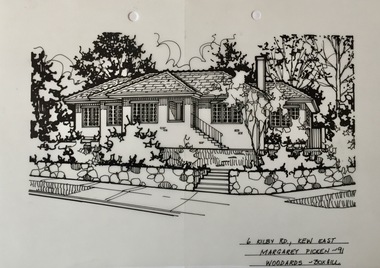 Kew Historical Society Inc
Drawing - Property Illustration, Margaret Picken, 6 Kilby Road, Kew East, 1991
After training as a Cartographic Draftsman within the mining industry, I worked as a property illustrator for real estate firms in the eastern suburbs of Melbourne for 23 years from 1983. I initially photographed houses with a Polaroid camera and made a 'thumbnail' sketch while there. The photos were used to scale off a sketch in pencil and then that sketch was overlaid with drafting film and the 'pen and ink' completed. The pens I used were the Rotring ‘Rapidigraph’ drafting pens. The ink was also made by Rotring (German).The film was ‘Rapidraw’, polyester drafting film, double matte. It takes a very fine line and doesn’t bleed. As well as house sketches, there were often floor plans and site plans ordered. Aerial sketches were ordered when the property needed an overall view. (Margaret Picken, 2020)This drawing is one of a series created by Margaret Picken for real estate agents in Melbourne between 1983 and 2006. Each work is signed and dated by the artist.Gift of Margaret Picken, 2020Pen and ink drawing on drafting film of 6 Kilby Road, Kew East by Margaret Picken.6 KILBY RD., KEW EAST / MARGARET PICKEN ~91 / WOODARDS ~ BOX HILLartist -- margaret picken 1950-, property illustrations — buildings — kew east (vic.), 6 kilby road - kew east (vic) -
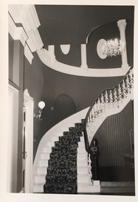
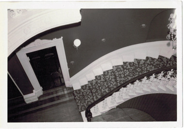 Kew Historical Society Inc
Photograph - 'Butleigh Wooton', 867 Glenferrie Road, John T Collins, 1979
in 1882 Thomas Maidment paid the Society of Jesus £5,750 for nine allotments along Barkly Road (now Glenferrie Road). Maidment, who had arrived in Australia from the Glastonbury district in England in 1858, owned and managed a number of sheep stations in Victoria and subsequently became an '... eminently respectable ...' member of District society. In 1883 the Rate Books list Maidment's land in Barkly Road as the 'Buxton Hill Estate' and it was given an N.A.V. of £90, while in the following year his property attracted an N.A.V. of £160, suggesting that substantial improvements were taking place. Maidment's two-storey mansion, named 'Butleigh Wooton' after his birth-place in England, was completed in 1885 and was given an initial N.A.V. of £420. While Maidrnent is recorded as the owner of the building until at least 1896, Jane Maidment, his wife, continued the family ownership of the twenty-six roomed house with its extensive grounds until at least 1910. (Sanderson P. City of Kew Urban Conservation Study Vol 2)Butleigh Wooton is a substantial two storeyed house built in the Italianate style common in the 1880s. Its walls are rendered and it has limited applied decoration that includes brackets to the eaves line and engaged ionic columns under a broken pediment over the front entrance. The bowed window unit is of particular distinction and is not at all typical of this type of building. This interior by John T Collins is a view of the staircase from the first floor landing. (Sanderson P. City of Kew Urban Conservation Study Vol 2)Reverse: "JOHN COLLINS / 11 Anderson Road / Hawthorn East, 3123 / Film 395 Exposure 27A / Kew / Butleigh Wooton / Looking down on stairs / 8-4-79thomas maidment, butleigh wooton, 867 glenferrie road -- kew (vic.) -
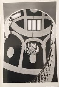
 Kew Historical Society Inc
Photograph - 'Butleigh Wooton', 867 Glenferrie Road, John T Collins, 1979
in 1882 Thomas Maidment paid the Society of Jesus £5,750 for nine allotments along Barkly Road (now Glenferrie Road). Maidment, who had arrived in Australia from the Glastonbury district in England in 1858, owned and managed a number of sheep stations in Victoria and subsequently became an '... eminently respectable ...' member of District society. In 1883 the Rate Books list Maidment's land in Barkly Road as the 'Buxton Hill Estate' and it was given an N.A.V. of £90, while in the following year his property attracted an N.A.V. of £160, suggesting that substantial improvements were taking place. Maidment's two-storey mansion, named 'Butleigh Wooton' after his birth-place in England, was completed in 1885 and was given an initial N.A.V. of £420. While Maidrnent is recorded as the owner of the building until at least 1896, Jane Maidment, his wife, continued the family ownership of the twenty-six roomed house with its extensive grounds until at least 1910. (Sanderson P. City of Kew Urban Conservation Study Vol 2)Butleigh Wooton is a substantial two storeyed house built in the Italianate style common in the 1880s. Its walls are rendered and it has limited applied decoration that includes brackets to the eaves line and engaged ionic columns under a broken pediment over the front entrance. The bowed window unit is of particular distinction and is not at all typical of this type of building. This interior by John T Collins is a view of the staircase from the first floor landing. (Sanderson P. City of Kew Urban Conservation Study Vol 2)Reverse: "JOHN COLLINS / 11 Anderson Road / Hawthorn East, 3123 / Film 395 Exposure 21A / Kew / Butleigh Wooton / Staircase / 8-4-79thomas maidment, butleigh wooton, 867 glenferrie road -- kew (vic.), john t collins -
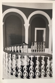
 Kew Historical Society Inc
Photograph - 'Butleigh Wooton', 867 Glenferrie Road, John T Collins, 1979
in 1882 Thomas Maidment paid the Society of Jesus £5,750 for nine allotments along Barkly Road (now Glenferrie Road). Maidment, who had arrived in Australia from the Glastonbury district in England in 1858, owned and managed a number of sheep stations in Victoria and subsequently became an '... eminently respectable ...' member of District society. In 1883 the Rate Books list Maidment's land in Barkly Road as the 'Buxton Hill Estate' and it was given an N.A.V. of £90, while in the following year his property attracted an N.A.V. of £160, suggesting that substantial improvements were taking place. Maidment's two-storey mansion, named 'Butleigh Wooton' after his birth-place in England, was completed in 1885 and was given an initial N.A.V. of £420. While Maidrnent is recorded as the owner of the building until at least 1896, Jane Maidment, his wife, continued the family ownership of the twenty-six roomed house with its extensive grounds until at least 1910. (Sanderson P. City of Kew Urban Conservation Study Vol 2)Butleigh Wooton is a substantial two storeyed house built in the Italianate style common in the 1880s. Its walls are rendered and it has limited applied decoration that includes brackets to the eaves line and engaged ionic columns under a broken pediment over the front entrance. The bowed window unit is of particular distinction and is not at all typical of this type of building. This interior by John T Collins is a view of the staircase from the first floor landing. (Sanderson P. City of Kew Urban Conservation Study Vol 2)Reverse: "JOHN COLLINS / 11 Anderson Road / Hawthorn East, 3123 / Film 395 Exposure 21A / Kew / Butleigh Wooton / Staircase looking up to dome / 8-4-79thomas maidment, butleigh wooton, 867 glenferrie road -- kew (vic.), john t collins -
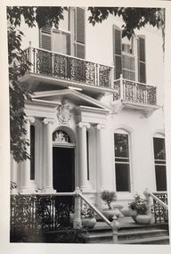
 Kew Historical Society Inc
Photograph - 'Butleigh Wooton', 867 Glenferrie Road, John T Collins, 1979
in 1882 Thomas Maidment paid the Society of Jesus £5,750 for nine allotments along Barkly Road (now Glenferrie Road). Maidment, who had arrived in Australia from the Glastonbury district in England in 1858, owned and managed a number of sheep stations in Victoria and subsequently became an '... eminently respectable ...' member of District society. In 1883 the Rate Books list Maidment's land in Barkly Road as the 'Buxton Hill Estate' and it was given an N.A.V. of £90, while in the following year his property attracted an N.A.V. of £160, suggesting that substantial improvements were taking place. Maidment's two-storey mansion, named 'Butleigh Wooton' after his birth-place in England, was completed in 1885 and was given an initial N.A.V. of £420. While Maidrnent is recorded as the owner of the building until at least 1896, Jane Maidment, his wife, continued the family ownership of the twenty-six roomed house with its extensive grounds until at least 1910. (Sanderson P. City of Kew Urban Conservation Study Vol 2)Butleigh Wooton is a substantial two storeyed house built in the Italianate style common in the 1880s. Its walls are rendered and it has limited applied decoration that includes brackets to the eaves line and engaged ionic columns under a broken pediment over the front entrance. The bowed window unit is of particular distinction and is not at all typical of this type of building. This interior by John T Collins is a view of the staircase from the first floor landing. (Sanderson P. City of Kew Urban Conservation Study Vol 2)Reverse: "JOHN COLLINS / 11 Anderson Road / Hawthorn East, 3123 / Film 395 Exposure 21A / Kew / Butleigh Wooton / Railing at head of stairs / 8-4-79thomas maidment, butleigh wooton, 867 glenferrie road -- kew (vic.), john t collins -
 Kew Historical Society Inc
Photograph - 'Butleigh Wooton', 867 Glenferrie Road, John T Collins, 1979
in 1882 Thomas Maidment paid the Society of Jesus £5,750 for nine allotments along Barkly Road (now Glenferrie Road). Maidment, who had arrived in Australia from the Glastonbury district in England in 1858, owned and managed a number of sheep stations in Victoria and subsequently became an '... eminently respectable ...' member of District society. In 1883 the Rate Books list Maidment's land in Barkly Road as the 'Buxton Hill Estate' and it was given an N.A.V. of £90, while in the following year his property attracted an N.A.V. of £160, suggesting that substantial improvements were taking place. Maidment's two-storey mansion, named 'Butleigh Wooton' after his birth-place in England, was completed in 1885 and was given an initial N.A.V. of £420. While Maidrnent is recorded as the owner of the building until at least 1896, Jane Maidment, his wife, continued the family ownership of the twenty-six roomed house with its extensive grounds until at least 1910. (Sanderson P. City of Kew Urban Conservation Study Vol 2)Butleigh Wooton is a substantial two storeyed house built in the Italianate style common in the 1880s. Its walls are rendered and it has limited applied decoration that includes brackets to the eaves line and engaged ionic columns under a broken pediment over the front entrance. The bowed window unit is of particular distinction and is not at all typical of this type of building. This interior by John T Collins is a view of the staircase from the first floor landing. (Sanderson P. City of Kew Urban Conservation Study Vol 2)Reverse: "JOHN COLLINS / 11 Anderson Road / Hawthorn East, 3123 / Film 395 Exposure 21A / Kew / Butleigh Wooton / Entrance / 8-4-79thomas maidment, butleigh wooton, 867 glenferrie road -- kew (vic.), john t collins