Showing 123838 items matching "main-road"
-
 Stawell Historical Society Inc
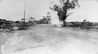
Photograph, Sloane's & Scotchman United Quartz Mining Co Looking East up upper Main Street c1916
Sloane's & Scotchman Mining Co Looking East up upper Main Street The back view of the Ore Bin can be seen. Street view looking uphill towards mine site. Cows grazing at right.stawell mining -
 Stawell Historical Society Inc
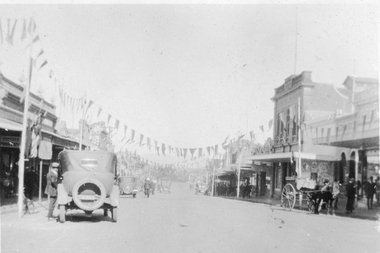
Photograph, Upper Main Street Stawell looking West c1920's
Upper Main Street looking West c1920's. Vehicles and bunting hanging from buildings. Carters Boot shop visible.stawell businesses streetscape -
 Stawell Historical Society Inc
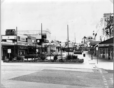
Photograph, Main Street looking East from Wimmera Street up to the Gold Reef Mall c1984
Main Street looking East from Wimmera Street up Gold Reef Mall Shows children's playground and Rotunda. C1984stawell businesses, streetscape -
 Stawell Historical Society Inc
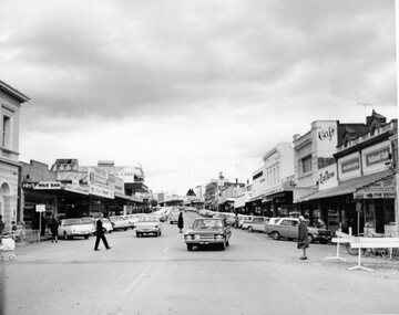
Photograph, Main Street Stawell looking East across Wimmera Street near Post Office with Vehicles angle parked c1970
Main Street Stawell looking east across Wimmera Street near Post Office. Vehicles angle parked in street c1970stawell streetscape -
 Stawell Historical Society Inc
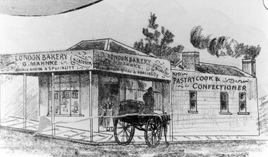
Drawing, Mr G. Mahnke, London Bakery on the corner of Main Street and Wimmera Streets Stawell c1890 -- Sketch
G. Mahnke London Bakery G. Mahnke corner of Main Street and Wimmera Street From Sketch series Circa 1890stawell businesses -
 Stawell Historical Society Inc
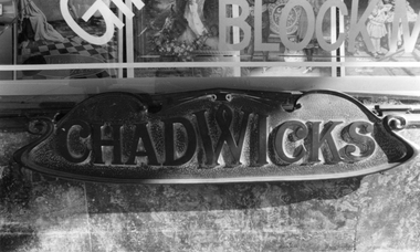
Photograph, Bronze inscription at the base of the Main Display window of Drapery business by Mr Josef. Chadwick
B/W photograph of a Bronze inscription still in place at the base of the Main Display window of the drapers business run by J. Chadwick.stawell business -
 Stawell Historical Society Inc
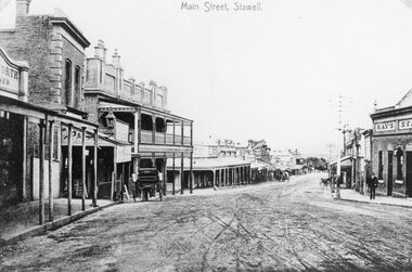
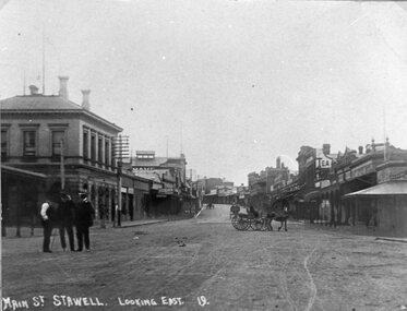
Photograph, Main Street Stawell looking West c1907 -- 2 Photos
Main Street Looking West. Kays Star Hotel c1907 Carters Boots. Bull and Mouth Hotel. Same as 6730-3stawell -
 Whitehorse Historical Society Inc.
Book, Wandering Whitehorse Road, 2014
A history of Whitehorse Road.A history of Whitehorse Road.A history of Whitehorse Road.whitehorse road, history -
 Whitehorse Historical Society Inc.
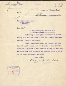
Letter - Correspondence, Mitcham Road, 1932
Correspondence between Shire Secretary, Shire of Blackburn and Mitcham and vendors and their solicitors re transfer of land for a road between Mitcham Road and Creek Road, Mitcham, June - July 1932.mitcham road, mitcham, creek road, mitcham, shire of blackburn and mitcham, maddocks, jamieson & lonie, solicitors, ashley (mr), bloom, f.a., roads and streets -
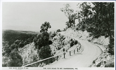 Mt Dandenong & District Historical Society Inc.
Photograph, The New Road to Mt. Dandenong Vic. c1935, c1935
Rose Series Postcard number 332c1935. Enlarged for display from Rose postcard 'New Road' (Mt. Dandenong Tourist Road). Completed by 1930 but no bitumen as yet. Road not wider and rail along outer edge.kalorama, rose series, mt. dandenong tourist road -
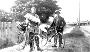 Surrey Hills Historical Society Collection
Photograph, Mr Joyce and Mr Lamble of Essex Road, Surrey Hills, c 1932, 1932
Date is approximate - early 1930s. Mr Oswald Joyce and Mr Bert Lamble used to ride their bicycles to the country to find work when they became unemployed. This included reworking old gold mines. Here they are seen leaving for Enoch's Point where they fossicked for gold during the Depression. A check of the electoral rolls points to this being the home of Frederick Harry Percival Lamble, labourer, born in Collingwood. He and his family continued to live at 87 Essex Road until his death in 1968 and his occupation is consistently given as labourer. His wife Bessie Louisa Woods died in 1957.Black and white photo of 2 men identified, but not specifically, as Mr Joyce and Mr Lamble, both of Essex Road, Surrey Hills. They are standing next to their bicycles on a roughly made path. The bikes are loaded up with swags and kit as if the two are about to depart on a journey. Behind is a picket fence and in the background the shops along Canterbury Road can be seen.essex road, frederick harry percival (mr), bicycles, depression, 1929-1939, unemployment, economic depression, mr joyce, bert lamble, frederick harry percival lamble, bessie ethel lamble, bessie ethel smith -
Whitehorse Historical Society Inc.
Map, Boronia Road, Canterbury Road intersection, c1970
Enlarged aerial photograph of the intersection of Canterbury and Boronia Roads. State Aerial Survey, Melbourne 1970 project.Enlarged aerial photograph of the intersection of Canterbury and Boronia Roads. State Aerial Survey, Melbourne 1970 project.Enlarged aerial photograph of the intersection of Canterbury and Boronia Roads. State Aerial Survey, Melbourne 1970 project.boronia road, vermont, canterbury road, vermont, mitcham road, vermont, frances avenue, vermont, nurlendi road, vermont, beaumont street, vermont, kingsclere street, vermont, webb court, vermont, aerial photographs -
 Stawell Historical Society Inc
Photograph, Wesleyan Church Main Street, Reefs Opened 1863
Wesleyan Church Main Street Reefs. Opened 1863. Part of a collection of Photographs by Mr. O.G. Armstrong as commissioned by the Shire of Stawell for the Inter-colonial and Paris Exhibition in Melbourne in 1866. This brick church, later known as the Wesley Centre, was opened for service on Christmas Day 1863. It was situated in the Main Street alongside the Town Hall which was constructed in 1872. The church was demolished for a car park in the 1980’s. Brick church building with two ornate towers beside front doors.stawell religion -
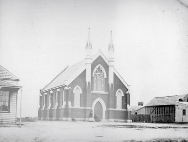
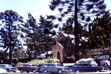 Greensborough Historical Society
Photograph - Digital image, Methodist Church and Stubleys Main Street, Greensborough, 1970c
The old Methodist Church in Main Street Greensborough was demolished in the 1970s for the development of Greensborough Plaza. The Church was sited near the present entrance to the Plaza.Digital copy of colour photograph.methodist church greensborough, main street greensborough -
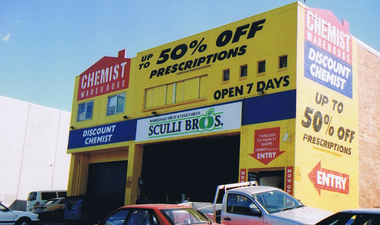 Greensborough Historical Society
Photograph - Digital image, Frank Solomon, Rear of Chemist Warehouse, Main Street Greensborough, 04/06/2010
Rear of Chemist Warehouse, Main Street Greensborough, still showing the Sculli's sign. Sculli's now operate from a store in Greensborough Plaza.Digital copy of colour photographmain street greensborough, sculli family, chemist warehouse greensborough -
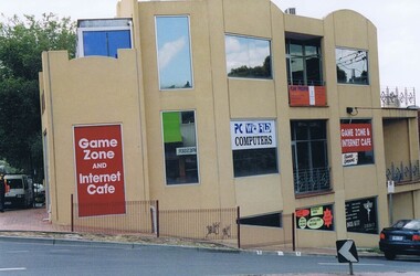 Greensborough Historical Society
Photograph - Digital image, Frank Solomon, PC World corner Grimshaw and Main Streets Greensborough, 04/06/2010
PC World, corner Grimshaw and Main Streets Greensborough. This building was the former office of John Cecil Jessop, known locally as 'Jessop's Corner'.A record of the changing face of Greensborough.Digital copy of colour photographgrimshaw street greensborough, main street greensborough -
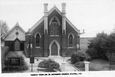 Stawell Historical Society Inc
Photograph, Stawell Methodist Church in Main Street Stawell -- Postcard
Stawell Methodist Church. Main Street Stawell. Original Post Card. Murray Views No. 29. Sunday School behind Church on left.stawell -
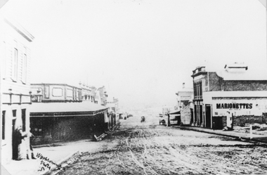 Stawell Historical Society Inc
Photograph, Main Street Stawell looking West from Doyle Lane c1906
Main St. looking West from Doyle Lane. Shows wooden 2 story Bull and Mouth Hotel on left. c 1906stawell business streetscape -
 Stawell Historical Society Inc
Photograph, Main Street Stawell looking East across Wimmera Street c1910
Main Street looking East across Wimmera Street c1910 Post Office on left. Horses and carts in street. Three men on roadway.stawell businesses streetscape -
 Stawell Historical Society Inc
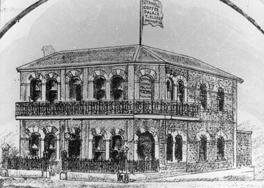
Drawing, Coffee Palace, formerly Castlemaine Hotel owned by Mr T Aldred on the corner of Main Street Stawell & Victoria Street fromthe P.C. News Supplement 1888 - Sketch
Coffee Palace T. Aldred formerly Castlemaine Hotel corner of Main Street and Victoria Street from P.C. News Supplement 1888stawell businesses -
 Stawell Historical Society Inc
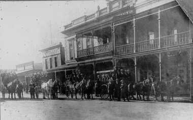
Photograph, Fully Loaded horse drawn carriages in Main Street Stawell
Main Street Scene Bone Saddlers and Harness Maker Times Newspaper Office. Whiteside's building at centre and Town Hall Hotel on Rightstawell -
Stawell Historical Society Inc
Archive - Blueprint, Methodist Church Main Street Plans, 20/10/1965
Alterations and additions to Stawell Methodist Church Main Street Earle and Associates Architects 25/10/1965 Job 6455 Drawing 3Paper in brown Cardboard roll holderreligion -
 Stawell Historical Society Inc
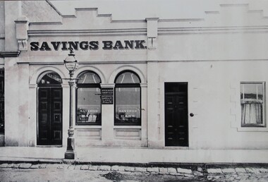
Photograph, Savings Bank in Upper Main Street Stawell -- opened 1880
Sepia Photo of Savings Bank Upper Main Street Stawell. First opened in 1880. Note the decorative Gas Fired street lamp. stawell -
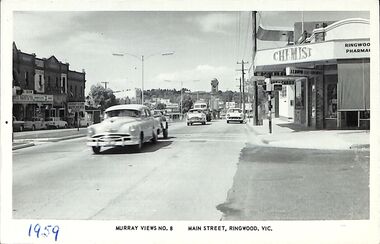 Ringwood and District Historical Society
Photograph/Postcard, Postcard - Murray Views No.8 - Main Street, Ringwood, Vic
Black and white "Murray Views" postcard - Eastward view from Railway Station Entrance along Maroondah Highway, Ringwood. Clocktower on Warrandyte Road corner. Circa early 1960s.1959 handwritten on front and back is incorrect - Early 1960s model cars in view. -
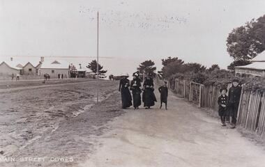 Phillip Island and District Historical Society Inc.
Photograph, Cowes Phillip Island, 1920
A stretch of the main Street of Cowes, looking towards Westernport Bay. A narrow strip of the Peninsula in the background. Left side of road depicts a group of buildings and Post Office. A Norfolk Pine in the background. On right side of road on footpath are three women and a child. The women are attired in long black dresses and large smart hats. Along side them is a picket fence, shrubby garden and a house. A small child and male figure popping out the gate.Thompson Avenue, CowesMain Street Coweslocal history, photographs, streetscape, cowes, black & white photograph, mary robb -
 Melbourne Tram Museum
Document - Research Notes, H. S. McComb, Domain Road, Park St, Toorak Road and Chapel St lines, c1930
Notes 6 pages, pinned together, giving details, opening dates, terminals, depot entries, sheave pits, curves, for the Domain Road, Park St, Toorak Road and Chapel St lines. Second set of notes 4 pages for the Port Melbourne and South Melbourne beach lines via City Road and Victoria St respectively. Single page sketches for both the Flemington Road via North Melbourne and Spencer St to North Melbourne lines - no dimensions or survey notes. Items 2064 to 2075 within box 72.3 in a brown folder marked "MT&O Co." red pencil on the front cover.trams, tramways, mto co, cable trams, drawings, reports, surveys, toorak rd, chapel st, south melbourne beach, port melbourne, city rd, victoria st, north melbourne, flemington rd -
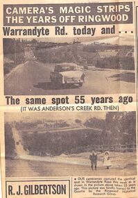 Ringwood and District Historical Society
Newspaper - Photographs and Clippings, Article comparing Warrandyte Road, Ringwood, in 1912 and 1967
Newspaper cutting showing a photos of Warrandyte Road, taken from Mullum Mullum Road, in 1912 and 1967.Extract from Eastern Post Gazette 13 December 1967, page 39 -
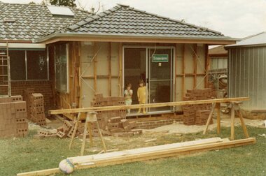 Ringwood and District Historical Society
Photograph, Adding a room onto the Mitchell house at 168 Oban Road, North Ringwood in February 1979
Near the corner of Cormistom Road and Florence Avenue onto Oban Road. The house is still there today (2024).Taken by Roy J Mitchell -
Whitehorse Historical Society Inc.
Document - Correspondence, Healesville Road, 1/09/1937
Claim for reimbursement from Country Roads Board for amounts expended on the Burwood Road by Shire of Blackburn and Mitcham.burwood road, roads and streets, shire of blackburn and mitcham, victoria. country roads board -
Whitehorse Historical Society Inc.
Document - Correspondence, Burwood Road, 25/11/1937
Claim for reimbursement from Country Roads Board for amounts expended on Burwood Road by Shire of Blackburn and Mitchamburwood road, shire of blackburn and mitcham, victoria. country roads board, roads and streets