Showing 10390 items
matching plan
-
 Lakes Entrance Regional Historical Society (operating as Lakes Entrance History Centre & Museum)
Photograph, Jemmeson, Edie, 1928
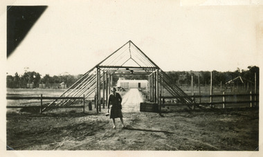
The fully self contained camp park containing accommodation, general store, entertainment rotunda, petrol bowsers and community kitchen was the vision of Richard Bromby Whiter who commenced the project in 1927. Water for gardening and sewerage supplied by an underground bore.Black and white photograph of the entrance to the planned Lakes Camping Park, fronting Roadknight Street, Lakes Entrance, Victoria.tourism, recreation, caravan parks -
 Lakes Entrance Regional Historical Society (operating as Lakes Entrance History Centre & Museum)
Photograph, Lakes Post Newspaper, 1996
Black and White Photograph of Helen Martin Director of Strategig Planning and Dev. 1995 Tambo Shire Gippsland Victoriamuincipal history -
 Lakes Entrance Regional Historical Society (operating as Lakes Entrance History Centre & Museum)
Photograph, Lakes Post Newspaper, 1995
Black and White Photograph of Helen Martin Director of Strategig Planning and Dev. 1995 Tambo Shire Gippsland Victoriamuincipal history -
 Wangaratta High School
WSC School Improvement Plan, 1989
White folder containing school report and analysis documents which form part of the 1989 school improvement plan -
 Bendigo Historical Society Inc.
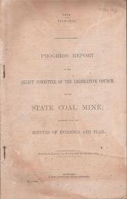
Document - DOCUMENT. PROGRESS REPORT, 1910
Document. Progress Report. Of the Select Committee of the Legislative Council on the State Coal Mine; Together with the Minutes of Evidence and Plan. -
 Ballarat Tramway Museum
Drawing - Drawings by Alwyn Marshall of the Philadelphia Streetcar system, Alwyn Marshall, 1959
Wal Jack had an extensive range of correspondents throughout Australia and the world who often prepared extensive drawings for him. This set of drawings of the extensive Philadelphia streetcar system would have taken many hours to prepare, before the days of colour photocopiers. Parts of the system remain in use.Demonstrates some of the correspondence that Wal Jack received from around the world.Set of 6 ruled foolscap sheets with a drawing or plan of the Philadelphia Streetcar routes and a type note on plain paper. letters, wal jack, tramways, drawings, streetcars, philadelphia, alwyn marshall -
 Kew Historical Society Inc
Book, McPhee Gribble, Living Places: twenty houses, 1987
Photographic project commissioned by The State Library of Victoria. "Two hundred of the four hundred photographs taken for the project are to be found at the State Library of Victoria ..."--Introd., p. 6.Fitzroy, Vic. : McPhee Gribble/Penguin, 1987 218 p. : ill., plans ; 21 x 25 cm. non-fictionPhotographic project commissioned by The State Library of Victoria. "Two hundred of the four hundred photographs taken for the project are to be found at the State Library of Victoria ..."--Introd., p. 6.housing -- australia, dwellings -- australia -- social aspects -
 Port Fairy Historical Society Museum and Archives
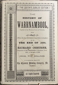
Book, Richard Osburne, The history of Warrnambool, capital of the western ports of Victoria, from 1847 (when the first government land sales took place) up to the end of 1886, 1980
The history of Warrnambool, capital of the western ports of Victoria, from 1847 (when the first government land sales took place) up to the end of 1886 / by Richard Osburne Other Authors, Fraser, Malcolm, 1930-2015, (author of introduction, etc.) Tylee Memorial Collection368 pages, unnumbered and folded leaves of plates : illustrations (some colour), maps, portraits, plans ; 19 cmnon-fictionThe history of Warrnambool, capital of the western ports of Victoria, from 1847 (when the first government land sales took place) up to the end of 1886 / by Richard Osburne Other Authors, Fraser, Malcolm, 1930-2015, (author of introduction, etc.) Tylee Memorial Collectionvictoria. warrnambool, 1847-1886. facsimiles, government policy - initial period and protectionism., settlement and contacts - 19th century., mining industry - gold., race relations - violent - massacres, religions - christianity - missions., warrnambool (vic.) -- history., framlingham / purnim (w vic sj54-11), demography - census data, book -
University of Melbourne, Burnley Campus Archives
Book - Report, E.B. Littlejohn, Victoria 1944 State Regional Boundaries Committee Report on Regional Boundaries, 1944
See paper catalogue for complete contents. Item formerly property of E.B. LittlejohnReport includes maps of Regions for Planning and Development, geographical, weather, power, water resources, crops, livestock, etc.e.b. littlejohn, planning, development, regions -
University of Melbourne, Burnley Campus Archives
Booklet, Braeside Metropolitan Park, 1985-1987
parks, hon a mccutcheon -
Canterbury History Group
Ephemera - "Terrappee" 26 Balwyn Road Canterbury, 1995
Real Estate advertisement for "Terrappee" 26 Balwyn Road Canterbury. includes interior and exterior photographs and floor plancanterbury, balwyn road, terrappee, coghill cleary first national -
Canterbury History Group
Ephemera - "Loch Ard" 24 Faversham Road Canterbury, 1996
Real Estate Advertisement for sale of "Loch Ard" 24 Faversham Road Canterbury. includes sketch of the house and planscanterbury, loch ard, faversham road, sinclair & co -
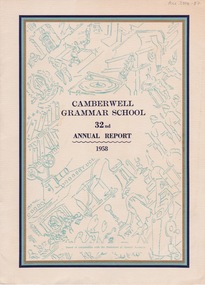 Camberwell Historical Society
Booklet (Item), Camberwell Grammar School, Camberwell Grammar School 32nd Annual Report 1958, 1958
camberwell, school -
Camberwell Historical Society
Document (Item) - Report, City of Boroondara, City of Boroondara Annual Report 1998/1999, 1999
boroondara -
Camberwell Historical Society
Document (Item) - Report, City of Boroondara, City of Boroondara Annual Report 2000, 2000
boroondara -
 Buninyong Visitor Information Centre
Document (Item) - Information Folder, Buninyong Mechanics Institute and Free Library
Copies of images showing the development of and changes to the library building.buninyong mechanics institute, buninyong library, buninyong -
Port Melbourne Historical & Preservation Society
Plan - Montague Housing Development
Provided to PMHPS by Steve Tserkezidis and follows on from his earlier materials on the Port Melbourne State Bank houses. See item 2824. Original source Public Records OfficeCOPYRIGHT PUBLIC RECORDS OFFICE Set of plans and documents relating to the State Savings bank, Montague Housing Development, in Gladstone St, Montague. This was an initiative of South Melbourne City Council to replace slum housing in Montague, 1935-40 .03 - 40 pages; .04 - 7 pages of A2 copies (some laminated)built environment - domestic, state savings bank of victoria -
Bendigo Historical Society Inc.
Plan - SANDHURST BOYS CENTRE COLLECTION: SANDHURST TRAINING CENTRE ADMINISTRATION BUILDING FLOOR PLAN
Photocopy of the Administration building floor plan, showing Clinic, switch room, store, sick ward with patients toilet, utility and cleaners rooms, nurses station, pantry, doctors office, waiting room, locker rooms, reception foyer, general office, offices for chief training officer and secretary. Location unknown 16.02.2023.bendigo, institutions, sandhurst boys centre, victoria. ministry of housing and construction; sandhurst training centre; floor plan - administration building; -
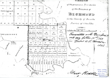 University of Melbourne, Burnley Campus Archives
Plan - Sketch, Sketch of the Proposed Boundaries of the Village of Richmond, 1843
Sketch of the proposed boundaries of the village of Richmond in the County of Bourke Parish of Jika-Jika. Handritten, "Transmitted with Descriptioon and my letter No 43/150 Dated 11th November 1843 Robert Hoddle." Shows Burnley Gardens site as, "Reserve. Survey Department." From Central Plan Office, Department of Natural Resources and Environmentrichmond, jika-jika, robert hoodle -
 Warrnambool and District Historical Society Inc.
Letter Book 4, 1901, 1908
This letter book has letters, invoices, sketch maps and plans and dates from 1908 to 1910. It came from the office of John William Crawley Junior, an engineer, architect and surveyor in private practice in Warrnambool and also the official engineer of the Shire of Warrnambool from 1895 to 1935. His father, brother and son were also engineers and worked in that capacity or as the Shire Secretary for the Shire of Warrnambool, with the Crawley family members recording a total of 132 years of service to the Shire. The letter book was passed on to John Crawley’s son, Rolf, Engineer for the Shire of Warrnambool from 1935 to 1968. The letter book then came into the possession of Michael Hand who took over the private surveying business of Rolf Crawley in Warrnambool and the Warrnambool and District Historical Society has acquired the letter book, one of several Crawley ledgers, from the Michael Hand estate. This letter book is of considerable significance as it contains maps, plans, sketches and written information on the work of John William Crawley, the engineer for the Shire of Warrnambool for 40 years. This is a black-covered letter book with copies of letters and field maps and plans and an alphabetical listing at the front. Some of the letters are invoices for work carried out. The leather section of the front cover has been almost completely torn away and the binding is mended with adhesive tape. There are some torn pages. The front page has a signature and a mauve stamp. ‘Letter Book’ ‘J.Wm. Crawley (Private)’ ‘ Rolf L. Crawley, Civil Engineer, Drainage and Water Supply Engineer, Licensed Surveyor, Registered Architect, Warrnambool’ ‘4’ rolf crawley, warrnambool, john william crawley, junior, warrnambool, history of warrnambool -
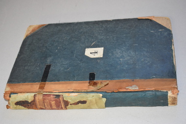
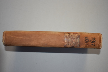 Warrnambool and District Historical Society Inc.
Letter book 7, 1917-1920, 1917
This letter book contains handwritten letters, sketch maps and plans and dates from 1917 to 1920. It comes from the office of John William Crawley Junior, an engineer, architect and surveyor in private practice in Warrnambool and also the engineer for the Shire of Warrnambool from 1895 to 1935. His father, brother and son were also engineers and worked in that capacity or as Shire Secretary for the Shire of Warrnambool, with the Crawley family recording 132 years of service with the Shire of Warrnambool. The Shire existed from 1863 to 1994. The letter book was passed on to John Crawley’s son, Rolf, the engineer for the Shire of Warrnambool from 1935 to 1968. The letter book then came into the possession of Michael Hand who took over the private surveying business of Rolf Crawley in Warrnambool. The Warrnambool and District Historical Society then acquired this letter book, along with other Crawley ledgers, from the Michael Hand estate. This letter book is of considerable significance as it contains letters, plans and maps drawn up John William Crawley Junior, the engineer for the Shire of Warrnambool for 40 years. It will be very useful for research. This is a hard cover book of 745 pages. It has leather trim on the cover edges and the spine with gold lettering on the spine. The leather covering is scuffed and torn. The inside covers have a mottled blue lining. The book contains maps, plans and handwritten letters and has an alphabetical index at the beginning of the book. Most of the pages have been water-stained. ‘7 Private’ ‘Letter Book 1917 to 1920’john william crawley junior, warrnambool, rolf crawley, warrnambool, shire of warrnambool -
 Bacchus Marsh & District Historical Society
Map, Bacchus Marsh Township and Nearby Districts Maps Volume
This volume of maps is believed to have been compiled by staff at the Shire of Bacchus Marsh and was presumably used to inform and assist Shire staff and Councillors in the carriage of their duties.This collection of maps are significant due to their rarity as many of them are unique maps made for local purposes in the Bacchus Marsh region. They are also of strong research value containing a wide variety of information including landholders, land sales, infrastructure, such as roads, bridges, public, commercial and private buildings, houses, land use, and geographic features over multiple decades from the late nineteen century into the middle part of the twentieth century.One bound volume of maps comprising cadastral maps, (indicating property owners and land boundaries), land plans and real estate auction plans and advertising material, and other maps indicating major infrastructure like proposed roads and irrigation areas. Most of the maps and plans are of Bacchus Marsh and nearby areas but some maps are of nearby towns such as Melton, Ballan and Blackwood. The volume comprises 52 pages. Most pages have a single map or plan pasted onto it but some contain 2 or 3 different maps. There are 81 maps in total. Map 1 Liquidators Sale 1896. Map 2. Woodside Estate Sale 1913. maps, maps bacchus marsh, maps bacchus marsh region -
Glen Eira Historical Society
Plan - Uniting Church Archives, Orrong Road, 78-66, Elsternwick
Six documents including plan and correspondence between Elsternwick Methodist Church, Public Health Department and Beddoe Pty Ltd concerning the application to make alterations and additions including the erecting of a brick kindergarten from 30/07/1937 to 03/03/1939.elsternwick methodist church, orrong road, beddoe pty ltd., halls, kindergarten, robinson c.h., briggs james r., beddoe f.g., charlesworth a.c., methodist church trust, town clerks, hoddle street -
Glen Eira Historical Society
Plan - Bambra Road, 271, Caulfield South
A hand-drawn plan (203mm x 297mm), most likely of 271 Bambra Road, Caulfield South. Also included are handwritten notes, likely dated 6/08/1953, calculating increase of rent and listing tenant as Mrs Griffiths (Legacy Widow).griffiths mrs, bambra road, caulfield south, rents, legacy, widows, houses -
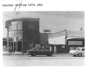 Ringwood and District Historical Society
Document, Certificate of Title and miscellaneous property records - Carter Real Estate, 122 and 124-128 Maroondah Highway, Ringwood, Victoria
Transfer of Land Act Title dated 24/4/2002 - Volume 10314 Folio 972 Crown Allotments 11H and 11J, Parish of Ringwood, Entitlement Grant to a depth of fifteen metres - 29/1/1997, City of Ringwood planning permit and diagram of office floor plan - 1973. -
Bendigo Historical Society Inc.
Map - CAMPBELL COLLECTION: BENDIGO AND DISTRICT MAPS
Map. Whirrakee, Parish of Whirrakee. Total area of map 4419 acres. Scale 20 chains to 1 inch. 23 allotments are sold, Eucalypt oil distillery on lower portion of map. Prepared in W.P.B. from Assessor's plan and Parish Plan. (number 350 in map cupboard 1)map, bendigo, allotments -
Whitehorse Historical Society Inc.
Article, Say no to pokies: shoppers alarm, 1992
Residents will fight plans to develop a tavern with 90 poker machines in Forest Hill Chase Shopping Centre.Residents will fight plans to develop a tavern with 90 poker machines in Forest Hill Chase Shopping Centre. Nunawading Council's strategic planning department's spokesman, Richard Schuster, said the 3rd level at the Centre has developed into an entertainment level. The matter has not gone before Council at this stage.Residents will fight plans to develop a tavern with 90 poker machines in Forest Hill Chase Shopping Centre.shopping centres, forest hill chase, city of nunawading, schuster, richard -
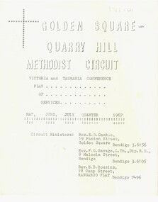
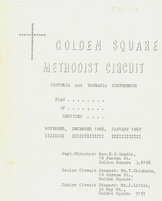 Bendigo Historical Society Inc.
Document - Golden Square Methodist Church, 11/11/1966
Golden Square Methodist Church is situated at 2a Laurel St., Golden Square and was built in 1852. It no longer serves as a church and was sold in 2016.Eight page booklet of the Victoria and Tasmania Conferences, and plan of services. Contains Circuit News and Notes, Plan of Services for divine worship for the Golden Square, specimen Hill, Kangaroo Flat and Lockwood Methodist Churches, financial statements for quarter ending 25th September 1966, and a list of the church officials.religion, lydia chancellor collection, history, church -
 Bendigo Historical Society Inc.
Document - Golden Square Methodist Church Circuit, 01/05/1967
Golden Square Methodist church is situated at 2a Laurel St., Golden Square and was built in 1852. It no longer serves as a church and was sold in 2016.Eight page booklet of the Victoria and Tasmania Conferences, and plan of services. Contains Circuit News and Notes, Plan of Services for divine worship for the Golden Square, specimen Hill, Kangaroo Flat and Lockwood Methodist Churches, financial statements for quarter ending 31 March 1967, and a list of the church officials.religion, lydia chancellor collection, history, church -
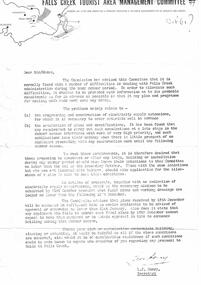 Falls Creek Historical Society
Letter - Commission Advises Of Difficulties In Administration During Summer Period, October 1961
Bob (Herman) Hymans (a former member of the Royal Netherlands Navy) was born in Bloemendaal, Holland on 30th September 1922. During World War II he fought against the Japanese in the Dutch East Indies (now Indonesia) and was imprisoned in Changi and on the Burma Railway. After gaining qualifications as a Ski Instructor, Bob arrived in Falls Creek in July 1950. Working as an Instructor and Supervisor at Bogong Lodge, Bob decided his future was in accommodation. He was successful in negotiating an indenture for land from the State Electricity Commission (SEC). It took Bob two years to build his Grand Coeur Chalet but, tragically, it was burned down in August 1961. Bob also built the first Chairlift in Australia. This was a single chairlift and the structure was built from wooden electricity poles. He was constantly full of new ideas and proposals for the village. Bob Hymans die on 7th July 2007. This Collection of documents and letters tells the story of Bob's endeavours to develop Falls Creek into the ski village it is today.This letter is significant because it documents developments made or endorsed by the Falls Creek Tourist Area Management Committee.A letter from the Management Committee outlining potential delays for the SEC in regard to programming and construction of extensions to the electricity supply over the summer. Early notification of plans for any extensions or new developments requiring additional supply were required by 31st October with full plans to be submitted by 15th December. falls creek tourist area management committee, chairlift licence negotiations, double chairlift