Showing 3906 items matching "bricker"
-
 Wodonga & District Historical Society Inc
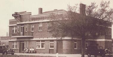
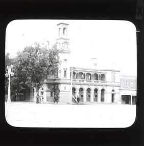
Photograph - Wodonga Hotel, now Elgin's
The Wodonga Hotel was constructed in 1940 at a cost of £10,000. It is now called Elgins Hotel. It was established after the transfer of the licence from the Halfway Hotel. This was the result of a lengthy hearing before the Licensing Board over two days in December 1939, There was some opposition from established guest house keepers and hotelkeepers. G. A. Adams, owner of the Carriers’ Arms Hotel was refused a hearing as he was not a resident, so Rachael Spence his manageress objected on the ground that it would do her hotel a lot of harm. Mr Luke Murphy represented the applicants, Irene Weatherall and Lena Pickering. He stated that the new structure would be of brick, cement and iron and contain 22 rooms. The site was near the municipal sale yard and near the railway station, and, he pointed out the trucking industry, which he believed to be larger than any other in Victoria, outside of Melbourne. The hearing was told of the bad state of the Half Way Hotel, having been there for almost 100 years. Luke Murphy was quoted as saying “If Hovell were here he could give evidence on that.” The lack of accommodation and quality accommodation at Wodonga hotels was frequently heard of. Costa’s Wine Café had very excellent accommodation for but only five or six people. The lessee of the-tea rooms at the municipal saleyards, also gave evidence. Mrs Lowden said that on sale day she served up to 130 dinners in addition to 10 or 20 breakfasts, and almost continuous light lunches. She did not think a hotel would provide a needed facility for patrons of the saleyards. In April 1940 the application was granted on the condition that premises were erected within 42 weeks. The hotel was used for soldier accommodation during World War II and experienced a boom period when Wodonga saleyards were located across the road. Irene House behind the pub also was constructed in the 1970s when Albury-Wodonga had been identified as a National Growth Centre by the Whitlam Labor government. After running the hotel for 5 generations, the Weatherall Family sold the business in 2021.These images represent an early business in Wodonga . 2 photos of the Wodonga Hotel and 1 newspaper advertisementwodonga businesses, a. e. costa, wodonga pioneers, early wodonga businesses, wodonga businesses high street -
 National Wool Museum
Document - The Fading Dream of Australian Home Ownership, Design and Photograph, Judy Turner, 1989
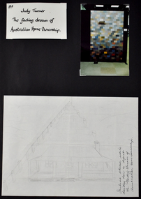
‘The Fading Dream of Australian Home Ownership’ was made by Judy Turner in 1989 for her son Nicholas (then 14 years) after a family discussion about mortgages and rising interest rates (17% at the time), out of concern for his generation. “Perhaps this will keep my son warm when he can’t afford a house”, wrote Judy at the time. As a quilting teacher for over thirty years, Judy was well aware of the ‘wagga’ tradition of making do with what you have and reusing resources to make something useful. The quilt was made using approximately 270 different men’s woollen suiting samples. The fabrics in the quilt were a gift from Micheal Haze who was a travelling men’s ware salesman and friend of the artist’s late husband. The suiting samples were used just as they were, without cutting, and are stacked liked house bricks. The pieces have been machine pieced and tied. The quilt has woollen backing, with no batting. Judy’s son Nicholas, always interested in drawing, and keen to see what his mother was making, helped with the drawing and design of the house. The quilt has been exhibited in Canberra, Armidale and Sydney and featured in publications in Australian and Japan. Judy’s work has been exhibited Nationally and Internationally, including in Japan, Korea, Germany, Switzerland and the United States of America. Judy’s work has featured extensively in publications around the world, and has received many awards. Her work is held in public and private collections across Australia and the USA. As well as a successful career as an artist, Judy spent three decades imparting skills to the next generation as a patient and skilled teacher. ARTIST STATEMENT The medium of my artistic practice is quilt making and my focus is the use of colour and speedy, accurate and efficient methods of making successful quilts. In 1995 I developed an original technique of applying woollen yarn to a woollen background, focusing on the subtle blending of colour to express an idea. Author of Awash With Colour (1997) and co-author with Margaret Rolfe of Successful Scrap Quilts (2002).Folio page depicting three items attached to a black card background. One item is a title written in black ink on white background, another is a photograph of a quilt, the third shows a hand drawn sketch of a house with a verandah.Front: [handwritten] 95 / Judy Turner / The fading dream of / Australian Home Ownership. / Initial sketch while / deciding how to depict / the Fading Dream of / Australian Home Ownership.quilt, wagga, home, house, housing affordability, design -
 National Wool Museum
Textile - Quilt, Judy Turner, The Fading Dream of Australian Home Ownership, 1989
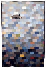
‘The Fading Dream of Australian Home Ownership’ was made by Judy Turner in 1989 for her son Nicholas (then 14 years) after a family discussion about mortgages and rising interest rates (17% at the time), out of concern for his generation. “Perhaps this will keep my son warm when he can’t afford a house”, wrote Judy at the time. As a quilting teacher for over thirty years, Judy was well aware of the ‘wagga’ tradition of making do with what you have and reusing resources to make something useful. The quilt was made using approximately 270 different men’s woollen suiting samples. The fabrics in the quilt were a gift from Micheal Haze who was a travelling men’s ware salesman and friend of the artist’s late husband. The suiting samples were used just as they were, without cutting, and are stacked liked house bricks. The pieces have been machine pieced and tied. The quilt has woollen backing, with no batting. Judy’s son Nicholas, always interested in drawing, and keen to see what his mother was making, helped with the drawing and design of the house. The quilt has been exhibited in Canberra, Armidale and Sydney and featured in publications in Australian and Japan. Judy’s work has been exhibited Nationally and Internationally, including in Japan, Korea, Germany, Switzerland and the United States of America. Judy’s work has featured extensively in publications around the world, and has received many awards. Her work is held in public and private collections across Australia and the USA. As well as a successful career as an artist, Judy spent three decades imparting skills to the next generation as a patient and skilled teacher. ARTIST STATEMENT The medium of my artistic practice is quilt making and my focus is the use of colour and speedy, accurate and efficient methods of making successful quilts. In 1995 I developed an original technique of applying woollen yarn to a woollen background, focusing on the subtle blending of colour to express an idea. Author of Awash With Colour (1997) and co-author with Margaret Rolfe of Successful Scrap Quilts (2002).Quilt featuring block pieces in tones of grey, blue, tan and brown, graduating in light to dark tones from top to bottom. The top third features a house with a verandah.quilt, wagga, home, house, housing affordability, design -
 National Wool Museum
Document - The Fading Dream of Australian Home Ownership, Design and Fabric Sample, Judy Turner, 1989
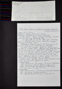
‘The Fading Dream of Australian Home Ownership’ was made by Judy Turner in 1989 for her son Nicholas (then 14 years) after a family discussion about mortgages and rising interest rates (17% at the time), out of concern for his generation. “Perhaps this will keep my son warm when he can’t afford a house”, wrote Judy at the time. As a quilting teacher for over thirty years, Judy was well aware of the ‘wagga’ tradition of making do with what you have and reusing resources to make something useful. The quilt was made using approximately 270 different men’s woollen suiting samples. The fabrics in the quilt were a gift from Micheal Haze who was a travelling men’s ware salesman and friend of the artist’s late husband. The suiting samples were used just as they were, without cutting, and are stacked liked house bricks. The pieces have been machine pieced and tied. The quilt has woollen backing, with no batting. Judy’s son Nicholas, always interested in drawing, and keen to see what his mother was making, helped with the drawing and design of the house. The quilt has been exhibited in Canberra, Armidale and Sydney and featured in publications in Australian and Japan. Judy’s work has been exhibited Nationally and Internationally, including in Japan, Korea, Germany, Switzerland and the United States of America. Judy’s work has featured extensively in publications around the world, and has received many awards. Her work is held in public and private collections across Australia and the USA. As well as a successful career as an artist, Judy spent three decades imparting skills to the next generation as a patient and skilled teacher. ARTIST STATEMENT The medium of my artistic practice is quilt making and my focus is the use of colour and speedy, accurate and efficient methods of making successful quilts. In 1995 I developed an original technique of applying woollen yarn to a woollen background, focusing on the subtle blending of colour to express an idea. Author of Awash With Colour (1997) and co-author with Margaret Rolfe of Successful Scrap Quilts (2002).Folio page depicting three items attached to a black card background. One item is a red, blue, black and white textile sample, another is a hand drawn sketch of a house, the third shows hand written text on lined paper in black ink.Front: [handwritten] Final / design / for housequilt, wagga, home, house, housing affordability, design -
 National Wool Museum
Document - The Fading Dream of Australian Home Ownership, Letters, Judy Turner et al, 1991
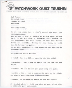
‘The Fading Dream of Australian Home Ownership’ was made by Judy Turner in 1989 for her son Nicholas (then 14 years) after a family discussion about mortgages and rising interest rates (17% at the time), out of concern for his generation. “Perhaps this will keep my son warm when he can’t afford a house”, wrote Judy at the time. As a quilting teacher for over thirty years, Judy was well aware of the ‘wagga’ tradition of making do with what you have and reusing resources to make something useful. The quilt was made using approximately 270 different men’s woollen suiting samples. The fabrics in the quilt were a gift from Micheal Haze who was a travelling men’s ware salesman and friend of the artist’s late husband. The suiting samples were used just as they were, without cutting, and are stacked liked house bricks. The pieces have been machine pieced and tied. The quilt has woollen backing, with no batting. Judy’s son Nicholas, always interested in drawing, and keen to see what his mother was making, helped with the drawing and design of the house. The quilt has been exhibited in Canberra, Armidale and Sydney and featured in publications in Australian and Japan. Judy’s work has been exhibited Nationally and Internationally, including in Japan, Korea, Germany, Switzerland and the United States of America. Judy’s work has featured extensively in publications around the world, and has received many awards. Her work is held in public and private collections across Australia and the USA. As well as a successful career as an artist, Judy spent three decades imparting skills to the next generation as a patient and skilled teacher. ARTIST STATEMENT The medium of my artistic practice is quilt making and my focus is the use of colour and speedy, accurate and efficient methods of making successful quilts. In 1995 I developed an original technique of applying woollen yarn to a woollen background, focusing on the subtle blending of colour to express an idea. Author of Awash With Colour (1997) and co-author with Margaret Rolfe of Successful Scrap Quilts (2002).Two typed letters held together with a staple. The first letter has a grey printed letter head which includes a logo of a person with wings holding a heart.[printed] PATCHWORK QUILT TSUSHINquilt, wagga, home, house, housing affordability, design -
 Federation University Historical Collection
Photograph - Brewery Building, Ballarat School of Mines Brewery Building, 06/10/2011
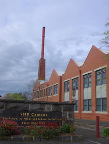
In 1872 William Tulloch and Alexander McLaren constructed a new brick 'Royal Standard Brewery' to the design of architect Henry R. Caselli. They had been operating a much smaller 'Royal Standard' Brewery, possibly since 1859. The Ballarat Brewing Company was established in 1895 and took over operations of the 'Royal Standard'. This new company resulted in the merger of the 'Royal Standard Brewery', James Coglans 'Phoenix Brewery' (Warrenheip) and Henry Leggo's 'Barley Sheaf Brewery' (Creswick Rd). J. Coglan and W. Tulloch were principals of the new company. By 1912 the Ballarat Brewery buildings fronting Armstrong Street were upgraded and new plant installed. Ballarat Brewing Company was well established as a thriving business. In 1926 'Ballarat Bertie' (the cellar-man) advertising image was introduced. It was used successfully until 1994 on 'Ballarat Bitter' labels. During the1940s and 50s the Ballarat Brewing Company was significantly upgraded and extended equipment and buildings. In 1959 Carlton and United Breweries purchased the Ballarat Brewery, its brewing rights and the land (but not the 114 BBC hotels or the Dana Street offices). The Lydiard Street frontage become the 'front' of the CUB Brewery. CUB ceased brewing at the Ballarat Brewery site in 1989 and closed the plant. Four years later the 'brewery site' was purchased by the Ballarat School of Mines to enlarge its campus area as TAFE was a rapidly expanding areas of education. In 1994 plans were developed for the 'Brewery Complex' with careful regard for needed educational facilities and due concern regarding historical aspects of the site and its buildings. There was close consultation and cooperation with the Ballarat City Council during the planning process. In 1995 most of the Brewery buildings were demolished by some special structures and features are preserved. The old brewery chimney was retained as a permanent reminder of the original industrial site, as were two boilers. The SMB Brewery Complex was completed in 1996 and reflects aspects of the former brewery's appearance. It was opened by Prime Minister John Howard on 28 February 1997. Further details at http://guerin.ballarat.edu.au/curator/buildings/site_listing_brewery-complex.shtml Twenty five colour photographs of the Brewery Building at the University of Ballarat SMB (Ballarat School of Mines) campus. The Brewery Building is built on the site of the former Ballarat Brewery and incorporates the chimney and 'Cowley' boilers from that site. ballarat school of mines, henry richards caselli, henry caselli, ballarat brewing, brewery, beer, cowleys foundry, carlton and united breweries, ballarat brewery site -
 Eltham District Historical Society Inc
Photograph - Digital Photograph, Marguerite Marshall, St John's Anglican Church, Diamond Creek, 7 September 2008
The building was designed by Charles Maplestone of Heidelberg, son-in-law to Anthony Beale of St Helena. Maplestone was a prominent architect who came out to Australia with his family in 1852. The foundation stone was laid by Mrs Isabella Maplestone on 11th November 1867. The bricklayers for the church were George Stebbing, H Limmer, H Spicer and a Mr Timm while Thomas Day was the stonemason. Another three years were to pass before sufficient money could be raised for its completion. It was opened by Bishop Perry on 1st November, 1870. The church bell which hung under a tree for 50 years until it was incorporated in the parish hall was brought out from England and presented by Charles Orme. In 1916, the estate of George Martin Pizzey left sufficient money to build the red brick hall, which still stands today (2023) though in January 1969 the hall and bell tower were badly damaged by bushfire. Coincidentally the former home of benefactor, George Pizzey was destroyed in the same fire. Of particular significance are the interior and exterior of the church, the Sunday school and hall with emphasis on pre-World War I fabric (excluding the 1990s additions) and the three coloured glass windows currently suspended in the 1990s entry foyer. In 2011 further alterations were made to the front of the Church. The church is historically significant because it was the oldest public building in the former Diamond Valley Shire, is amongst the oldest buildings in the Shire of Nillumbik and is associated with the early settlement of the Diamond Creek district. The church is historically, socially and spiritually significant because it has been a place of worship for over 150 years and continues to be, an important meeting place in the Shire. The church is aesthetically significant for the three stained glass windows executed by the noted stained glass manufacturers, Ferguson & Urie, as well as the supporting coloured glass windows in the church. The Sunday school & parish hall is architecturally significant because the hall is a well executed and preserved example of the work of noted church architects, North & Williams. It is historically significant because it is connected with local parishioner and Melbourne industrialist, George Pizzey, who bequeathed funds for its construction. Covered under Heritage Overlay, Nillumbik Planning Scheme. National Estate Ntionl Trust of Australia (Victoria) Local significance Published: Nillumbik Now and Then / Marguerite Marshall 2008; photographs Alan King with Marguerite Marshall.; p85 St John’s Anglican Church stands like a beacon on the hill on Main Street, Diamond Creek. Today the church has a large congregation, but its early years were marked by a small congregation struggling to find enough money to survive. It was gold in Diamond Creek that resulted in the building of this National Trust registered property.1 This church is far removed from William Wilson’s humble barn (later the Bowling Green) where the first Anglican church services were conducted – probably the first in the district.2 In the mid 19th century services were infrequent as the Rev Francis Hales, travelling on horseback, also conducted services elsewhere, including at Heidelberg, Coburg, Kinglake, Arthurs Creek, St Andrews and Kangaroo Ground. In 1860 Diamond Creek came under the jurisdiction of the Eltham Parish. Until the mid 1860s the Diamond Creek settlement included only about 20 families who were struggling farmers. But this changed when gold was found in 1862. Then the township grew to 200 families, including miners, civil administration workers and shopkeepers. The resulting growth of Church of England adherents prompted them to petition the Government in 1866 for land to build a church. The area chosen, on which the original building still stands, was at the centre of the proposed township. Today church leaders believe that this conspicuous location is one of the reasons for its exceptional growth. Prominent architect Charles Maplestone designed the building as he did the Presbyterian Church at Kangaroo Ground. St John’s, which is still intact, was built in the Gothic Revival style with the traditional rectangular plan of a central nave and sanctuary at the end. It is typical of small churches built in Victoria at that time, with polychromatic hand-made bricks, a porch, diagonal buttresses and a slate roof.3 The church was officially opened by Lord Bishop Perry on November 1, 1870. But during the next 40 years, due to the varying fortunes of gold mining, the church struggled to remain viable. In 1909 it separated from the Eltham Parish to form a parish with Greensborough. Life became more difficult with the privations of World War One. Then disaster struck in 1915 when fire destroyed the Diamond Creek Gold Mine, wiping out the major livelihood of most parishioners. However the church’s morale was lifted in 1916, when it received a bequest to build the red brick hall, from late parishioner and prominent leather manufacturer, George Pizzey. As prosperity grew, in 1924 the congregation separated from Greensborough, but they rejoined in the 1930s Depression. In the 1950s the wider population soared, impacting on St John’s, and it became a separate parish, becoming responsible for six churches at St Andrews, Hazel Glen, Hurstbridge, St Helena and Yarrambat. As parishioner numbers outgrew the building, extensions were added in 1989 and then in 1993, blending in well with the original building. Church members have made a huge contribution to the local community. John Ryan was a Heidelberg Shire Councillor for 25 years from 1931, Mayor in 1939 and headed several local sporting and other organisations. His son Jock became a clergyman and a local historian heading the Nillumbik Historical Society. Another parishioner, Dr Ted Cordner, came to Diamond Creek in 1920. One of his sons Donald, who was a local doctor, won the Brownlow Medal, was President of the Melbourne Cricket Club and President of the Melbourne Grammar School Council. Roy ‘Monty’ Vale was a state Liberal MP and was related to May Vale, a member of the Heidelberg School of Artists.4 In the early 21st century St John’s Anglican Church is one of the fastest growing congregations in Melbourne. References: St Johns Anglican Church complex, Sunday School and Parish Hall 61 Main Street DIAMOND CREEK, NILLUMBIK SHIRE. (2023, June 7). Retrieved from https://vhd.heritagecouncil.vic.gov.au/places/64023 Diamond Creek, VIC. – St John’s Anglican (2023, June 7). Retrieved from https://www.churchhistories.net.au/church-catalog/diamond-creek-vic-st-johns-anglican This collection of almost 130 photos about places and people within the Shire of Nillumbik, an urban and rural municipality in Melbourne's north, contributes to an understanding of the history of the Shire. Published in 2008 immediately prior to the Black Saturday bushfires of February 7, 2009, it documents sites that were impacted, and in some cases destroyed by the fires. It includes photographs taken especially for the publication, creating a unique time capsule representing the Shire in the early 21st century. It remains the most recent comprehenesive publication devoted to the Shire's history connecting local residents to the past. nillumbik now and then (marshall-king) collection, st john's anglican church, diamond creek -
 Federation University Historical Collection
Photograph - Photograph (colour), N.L. Harvey & Sons Photographers, Prince Charles visits Ballarat Institute of Advanced Education, 1974, 28/10/1974
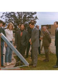
The Prince of Wales visited Mt Helen on 28 October 1974. At that time the campus was four years old. In September 2022, after the death of Queen Elizabeth II, Prince Charles became King Charles III..1) Visit of Prince Charles to the Ballarat Institute of Technology. Five men stand outside a single storey brick building with large windows. .2) Same as for .1) but in colour. Student Union President Peter Shepherd is in the photograph. .3) Prince Charles and students from the Ballarat College of Advanced Education. .4) Prince Charles and Minister Lindsay Thompson .5) Four men gather around Ballarat College of Advanced Education Metallurgy Student, Michael Martin, as he demonstrates a projection microscope to Prince Charles. From left to right: Lindsay Thompson (State Minister for Education), E.J. Barker (Director Ballarat College of Advanced Education), Brian Sunter (Head of Metallurgy), Michael Martin (student). .6) Prince Charles with Brian Sunter, Head of Metallurgy and student Michael Martin examining a projection microscope. .7) Prince Charles, E.J. Barker and Ballarat College of Advanced EducationPrince Charles and a party of Ballarat College of Advanced Education studentsstudents .8) Prince Charles and a party of Ballarat College of Advanced Education students .9) Prince Charles and a party of Ballarat College of Advanced Education students .10) Prince Charles talks to Ballarat College of Advanced Education students .11) Prince Charles and E.J. Barker .12) Prince Charles and party inspect students working on equipment. .13) Prince Charles, students, Minister for Education Lindsay Thompson and Brian Sunter .14) Prince Charles and a party of Ballarat College of Advanced Education studentsVerso Handwritten "Return to Director's Secretary" Stamped "Ballarat College of Advanced Education" Handwritten "Visit of Prince of Wales 28 Oct 74" Stamped "N.L. Harvey & Sons photographers.ballarat college of advanced education, mt helen, jack barker, prince of wales, bcae, prince charles, michael martin, mike martin, lindsay thompson, ej barker, brian sunter, colin kline, peter shepherd, minister for education, royal visit, royalty, prince charles iii -
 Bendigo Historical Society Inc.
Photograph - HILDA HILL COLLECTION: BLACK AND WHITE PHOTOS, 1919-1924
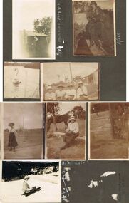
Series of Black and White Photos Post War Life for Hill Family & Friends. Total 8 Photos. Kath 'The Ranche' Eppalock September 1919. Kath dressed in 20's ? Dark dress, fur stole around neck, cloche hat, corrugated iron fence with wooden rail on top, garden setting. Arch, wearing white shirt waistcoat and dark trousers, gable roofed house in background, brick chimney left, tree at corner of house roof, Monte Video Queensland July 1924. Four ladies all wearing dark skirts and white blouses, all wearing broad rimmed hats, windmill tank on stand in background, tall post and wire netting, structure to the right, Kilmore October 1919. A Swan on the reservoir unknown place January 1920. lady wearing dark skirt and white blouse and hat, holding ball in left hand, right hand maybe swinging a tennis racquet ( not visible), post and rail fence in the far background. Lady sitting on stool wearing a dark skirt and white blouse, high post and wire netting fence, dark coloured horse to left, post and rail fence far right background, holding a camera bag and camera on stool beside her. Flirt the Dog, standing in doorway, door is broken and leaning to the right, shed has wide timber planks for cladding, 'The Ranche' Eppalock November 1919. Helen Mount Buffalo Tobogganing, wearing dark skirt, jacket with striped sleeves, and hat, August 1924.Hilda Hill Personal Collectionaustralia, history, post war life -
 Kew Historical Society Inc
Plan, Borough of Kew Detail Plan No.1577, 1904
The Melbourne and Metropolitan Board of Works (MMBW) plans were produced from the 1890s to the 1950s. They were crucial to the design and development of Melbourne's sewerage and drainage system. The plans, at a scale of 40 feet to 1 inch (1:480), provide a detailed historical record of Melbourne streetscapes and environmental features. Each plan covers one or two street blocks (roughly six streets), showing details of buildings, including garden layouts and ownership boundaries, and features such as laneways, drains, bridges, parks, municipal boundaries and other prominent landmarks as they existed at the time each plan was produced. (Source: State Library of Victoria)This plan forms part of a large group of MMBW plans and maps that was donated to the Society by the Mr Poulter, City Engineer of the City of Kew in 1989. Within this collection, thirty-five hand-coloured plans, backed with linen, are of statewide significance as they include annotations that provide details of construction materials used in buildings in the first decade of the 20th century as well as additional information about land ownership and usage. The copies in the Public Record Office Victoria and the State Library of Victoria are monochrome versions which do not denote building materials so that the maps in this collection are invaluable and unique tools for researchers and heritage consultants. A number of the plans are not held in the collection of the State Library of Victoria so they have the additional attribute of rarity.Original survey plan, issued by the MMBW to a contractor with responsibility for constructing sewers in the area identified on the plan within the Borough of Kew. The plan was at some stage hand-coloured, possibly by the contractor, but more likely by officers working in the Engineering Department of the Borough and later Town, then City of Kew. The hand-coloured sections of buildings on the plan were used to denote masonry or brick constructions (pink), weatherboard constructions (yellow), and public buildings (grey). MMBW Plan No.1577 includes some of the most significant houses in Kew: Herbert Henty’s ‘Roxeth’ (now part of Trinity Grammar), ‘Butleigh Wooton’, ‘Bokara’ and ‘Harrow’. It also includes the streets that have since changed their names. That part of College Parade linked to Glenferrie Road is now named College Place, College Parade now extends further north, and Charles Street did not yet reach Barkers Road. Roxeth is one of a number of Henty houses in Kew. Herbert Henty made his home here and was elected a member of Kew Municipal Council in 1864 and mayor in 1868-69. Walter Henry Serle, of Harrow served in the First World War. He was awarded the Military Medal ‘’For conspicuous bravery and devotion to duty. On 29th September near BELLICOURT he showed the greatest bravery and determination when his platoon was attacked by enemy bombing parties. It was due largely to his personal efforts that all the attacks were repulsed. Until wounded, his utter disregard of personal safety and boldness in dealing with the attacks were the means of saving the situation and were an inspiring example to his men.’melbourne and metropolitan board of works, detail plans, maps - borough of kew, mmbw 1577, cartography -
 Kew Historical Society Inc
Plan, Melbourne & Metropolitan Board of Works : Borough of Kew : Detail Plan No.1585, 1904
The Melbourne and Metropolitan Board of Works (MMBW) plans were produced from the 1890s to the 1950s. They were crucial to the design and development of Melbourne's sewerage and drainage system. The plans, at a scale of 40 feet to 1 inch (1:480), provide a detailed historical record of Melbourne streetscapes and environmental features. Each plan covers one or two street blocks (roughly six streets), showing details of buildings, including garden layouts and ownership boundaries, and features such as laneways, drains, bridges, parks, municipal boundaries and other prominent landmarks as they existed at the time each plan was produced. (Source: State Library of Victoria)This plan forms part of a large group of MMBW plans and maps that was donated to the Society by the Mr Poulter, City Engineer of the City of Kew in 1989. Within this collection, thirty-five hand-coloured plans, backed with linen, are of statewide significance as they include annotations that provide details of construction materials used in buildings in the first decade of the 20th century as well as additional information about land ownership and usage. The copies in the Public Record Office Victoria and the State Library of Victoria are monochrome versions which do not denote building materials so that the maps in this collection are invaluable and unique tools for researchers and heritage consultants. A number of the plans are not held in the collection of the State Library of Victoria so they have the additional attribute of rarity.Original survey plan, issued by the MMBW to a contractor with responsibility for constructing sewers in the area identified on the plan within the Borough of Kew. The plan was at some stage hand-coloured, possibly by the contractor, but more likely by officers working in the Engineering Department of the Borough and later Town, then City of Kew. The hand-coloured sections of buildings on the plan were used to denote masonry or brick constructions (pink), weatherboard constructions (yellow), and public buildings (grey). This plan, which covers parts of High Street, Pakington Street and Derby Street is dominated by two historic Kew mansions: ‘Konetta’ and ‘Ramornie’. Ramornie was constructed in 1890 for James Maitland Campbell, three times Mayor of Kew. Sold in 1940, it became a boarding house known as ‘The Towers’. Now a private residence again, it has only one of its three balconies remaining. The location of the missing two balconies can be seen on the plan. In 1903, the grounds of Ramornie included a large tennis court fronting Pakington Street. The rear of the property is shown as extending to Cobden Street. One of Kew’s oldest hotels, the Prospect Hill Hotel on the corner of High and Cobden Street was established in 1858. The outline of the hotel shown on the plan represents the second building on the site. During the 19th century it was often used for electoral meetings. The Prospect Hill Hotel was to be redeveloped again in 1928, by the local architect Robert McIntyre. Since the 1980s, the hotel has been a live music venue, the home of the Melbourne Jazz Club, a restaurant and a liquor outlet.melbourne and metropolitan board of works, detail plans, maps - borough of kew, mmbw 1585, cartography -
 Kew Historical Society Inc
Plan, Melbourne & Metropolitan Board of Works : Borough of Kew : Detail Plan No.1588, 1904
The Melbourne and Metropolitan Board of Works (MMBW) plans were produced from the 1890s to the 1950s. They were crucial to the design and development of Melbourne's sewerage and drainage system. The plans, at a scale of 40 feet to 1 inch (1:480), provide a detailed historical record of Melbourne streetscapes and environmental features. Each plan covers one or two street blocks (roughly six streets), showing details of buildings, including garden layouts and ownership boundaries, and features such as laneways, drains, bridges, parks, municipal boundaries and other prominent landmarks as they existed at the time each plan was produced. (Source: State Library of Victoria)This plan forms part of a large group of MMBW plans and maps that was donated to the Society by the Mr Poulter, City Engineer of the City of Kew in 1989. Within this collection, thirty-five hand-coloured plans, backed with linen, are of statewide significance as they include annotations that provide details of construction materials used in buildings in the first decade of the 20th century as well as additional information about land ownership and usage. The copies in the Public Record Office Victoria and the State Library of Victoria are monochrome versions which do not denote building materials so that the maps in this collection are invaluable and unique tools for researchers and heritage consultants. A number of the plans are not held in the collection of the State Library of Victoria so they have the additional attribute of rarity.Original survey plan, issued by the MMBW to a contractor with responsibility for constructing sewers in the area identified on the plan within the Borough of Kew. The plan was at some stage hand-coloured, possibly by the contractor, but more likely by officers working in the Engineering Department of the Borough and later Town, then City of Kew. The hand-coloured sections of buildings on the plan were used to denote masonry or brick constructions (pink), weatherboard constructions (yellow), and public buildings (grey). This plan shows the original configuration of the Kew Post Office, Court House and Police Station, which had opened in 1888. This configuration was to essentially remain until the purchase of the Court House and Police Station by the City of Boroondara in 2007 and its subsequent renovation. Interestingly, the MMBW surveyors incorrectly labelled parts of the complex. In the triangle in front of the Post Office, before the erection of the Kew Cenotaph in 1925, was located a lawn and the Queen Victoria Jubilee Fountain. While many of the shops on the south side of High street had been constructed by 1903 a number of sites were still used as vegetable gardens. Further along High Street, on the corner of Charles Street, the Salvation Army Barracks can be seen on the plan. These Barracks predate the later Citadel and ‘Young People’s Hall’ that were opened in 1919. At 22 Charles Street can be seen the house of James Venn Morgan. Hailed as the ‘father of Kew’, Morgan arrived in Melbourne in 1840. He was first engaged as a bookmaker, but a fortunate venture on the goldfields enabled him to purchase land in Kew. He conducted a market garden and dairy in Kew for many years.melbourne and metropolitan board of works, detail plans, maps - borough of kew, mmbw 1588, cartography -
 Kew Historical Society Inc
Plan, Melbourne & Metropolitan Board of Works : Borough of Kew : Detail Plan No.1591, 1905
The Melbourne and Metropolitan Board of Works (MMBW) plans were produced from the 1890s to the 1950s. They were crucial to the design and development of Melbourne's sewerage and drainage system. The plans, at a scale of 40 feet to 1 inch (1:480), provide a detailed historical record of Melbourne streetscapes and environmental features. Each plan covers one or two street blocks (roughly six streets), showing details of buildings, including garden layouts and ownership boundaries, and features such as laneways, drains, bridges, parks, municipal boundaries and other prominent landmarks as they existed at the time each plan was produced. (Source: State Library of Victoria)This plan forms part of a large group of MMBW plans and maps that was donated to the Society by the Mr Poulter, City Engineer of the City of Kew in 1989. Within this collection, thirty-five hand-coloured plans, backed with linen, are of statewide significance as they include annotations that provide details of construction materials used in buildings in the first decade of the 20th century as well as additional information about land ownership and usage. The copies in the Public Record Office Victoria and the State Library of Victoria are monochrome versions which do not denote building materials so that the maps in this collection are invaluable and unique tools for researchers and heritage consultants. A number of the plans are not held in the collection of the State Library of Victoria so they have the additional attribute of rarity.Original survey plan, issued by the MMBW to a contractor with responsibility for constructing sewers in the area identified on the plan within the Borough of Kew. The plan was at some stage hand-coloured, possibly by the contractor, but more likely by officers working in the Engineering Department of the Borough and later Town, then City of Kew. The hand-coloured sections of buildings on the plan were used to denote masonry or brick constructions (pink), weatherboard constructions (yellow), and public buildings (grey). That area of Kew bordered by Cotham Road, Park Hill Road, Ermington Lane (now Ermington Place), and Belmont Avenue contained some of the significant homes owned by Kew pioneers. Chief among these was ‘Park Hill’ on an enormous lot facing Park Hill Road. The Jubilee History of 1910 noted, six years after this plan was drawn, that: ‘Park Hill Road, forming the southern boundary of the cemetery, takes its name from Park Hill, the residence of Mr. Thomas Judd, who has resided there since December, 1852.’ Other named houses on the plan include ‘Ferndale’ facing Cotham Road; ‘Ermington’ adjacent to Judd’s Park Hill, facing Park Hill Road; and ‘Gilden’ and ‘Mont Belmont’ facing Belmont Avenue. Mont Belmont was designed by the architectural firm of Reed, Henderson and Smart for William George Lilley in 1887 and was completed in 1888. Lilley was Mayor of Kew in 1887-88, a Justice of the Peace and a member of the first Board of Guardians of Kew’s St. Hilary’s Church of England.melbourne and metropolitan board of works, detail plans, survey plans - borough of kew, mmbw 1591, cartography -
 Kew Historical Society Inc
Plan, Melbourne & Metropolitan Board of Works : Borough of Kew : Detail Plan No.1563, 1905
The Melbourne and Metropolitan Board of Works (MMBW) plans were produced from the 1890s to the 1950s. They were crucial to the design and development of Melbourne's sewerage and drainage system. The plans, at a scale of 40 feet to 1 inch (1:480), provide a detailed historical record of Melbourne streetscapes and environmental features. Each plan covers one or two street blocks (roughly six streets), showing details of buildings, including garden layouts and ownership boundaries, and features such as laneways, drains, bridges, parks, municipal boundaries and other prominent landmarks as they existed at the time each plan was produced. (Source: State Library of Victoria)This plan forms part of a large group of MMBW plans and maps that was donated to the Society by the Mr Poulter, City Engineer of the City of Kew in 1989. Within this collection, thirty-five hand-coloured plans, backed with linen, are of statewide significance as they include annotations that provide details of construction materials used in buildings in the first decade of the 20th century as well as additional information about land ownership and usage. The copies in the Public Record Office Victoria and the State Library of Victoria are monochrome versions which do not denote building materials so that the maps in this collection are invaluable and unique tools for researchers and heritage consultants. A number of the plans are not held in the collection of the State Library of Victoria so they have the additional attribute of rarity.Original survey plan, issued by the MMBW to a contractor with responsibility for constructing sewers in the area identified on the plan within the Borough of Kew. The plan was at some stage hand-coloured, possibly by the contractor, but more likely by officers working in the Engineering Department of the Borough and later Town, then City of Kew. The hand-coloured sections of buildings on the plan were used to denote masonry or brick constructions (pink), weatherboard constructions (yellow), and public buildings (grey). This plan covers the area between Barkers Road, Wrixon Street, Sackville Street and Brougham Place, much of it now occupied by Carey Baptist Grammar and Preshil schools. This was an area of large and prestigious homes in 1903, some with formally laid-out gardens, such as ‘Tower Hill’ and ‘Opawa’. ‘Kalimna’ was built in 1890-91 for William H. Jarman, an accountant, and ‘Blackhall’ at the same time for W.H. Roberts. Blackhall was to be acquired by the Salvation Army in 1915 and renamed ‘Catherine Booth Girls’ Home’. The Home accommodated girls, aged between 4 and 16. Kalimna and Blackhall are of significance as typical and intact late Victorian mansions and as such are two key Victorian buildings to have been built in Kew. Both Blackhall and Kalimna are now part of Preshil. ‘Fairview’ was for a long time occupied by the Sisters of St. Joseph of Cluny as a care home for the elderly, but it is now part of Carey Grammar School, as are the grounds of ‘Wagga Merne’, ‘Weemutta’, ‘Blakely’, ‘Daheim’ and ‘Mildura’ (later ‘Urangeline’), the last being particularly impressive in 1903, with a tennis court, conservatory, outhouses, and two bathrooms!melbourne and metropolitan board of works, detail plans, mmbw 1563, cartography -
 Kew Historical Society Inc
Plan, Melbourne & Metropolitan Board of Works : Borough of Kew : Detail Plan No.1574, 1905
The Melbourne and Metropolitan Board of Works (MMBW) plans were produced from the 1890s to the 1950s. They were crucial to the design and development of Melbourne's sewerage and drainage system. The plans, at a scale of 40 feet to 1 inch (1:480), provide a detailed historical record of Melbourne streetscapes and environmental features. Each plan covers one or two street blocks (roughly six streets), showing details of buildings, including garden layouts and ownership boundaries, and features such as laneways, drains, bridges, parks, municipal boundaries and other prominent landmarks as they existed at the time each plan was produced. (Source: State Library of Victoria)This plan forms part of a large group of MMBW plans and maps that was donated to the Society by the Mr Poulter, City Engineer of the City of Kew in 1989. Within this collection, thirty-five hand-coloured plans, backed with linen, are of statewide significance as they include annotations that provide details of construction materials used in buildings in the first decade of the 20th century as well as additional information about land ownership and usage. The copies in the Public Record Office Victoria and the State Library of Victoria are monochrome versions which do not denote building materials so that the maps in this collection are invaluable and unique tools for researchers and heritage consultants. A number of the plans are not held in the collection of the State Library of Victoria so they have the additional attribute of rarity.Original survey plan, issued by the MMBW to a contractor with responsibility for constructing sewers in the area identified on the plan within the Borough of Kew. The plan was at some stage hand-coloured, possibly by the contractor, but more likely by officers working in the Engineering Department of the Borough and later Town, then City of Kew. The hand-coloured sections of buildings on the plan were used to denote masonry or brick constructions (pink), weatherboard constructions (yellow), and public buildings (grey). This plan shows several very large houses, particularly along Glenferrie Road, and the area now occupied by Ruyton Girls’ School. ‘Tarring’ (incorrectly spelled here as ‘Karring’) was built for Henry Henty in 1872, on part of his original allotment of 20 acres, and ‘Mount View’, which retains its original building and the fountain in the front garden, is part of Ruyton’s Junior School. The most significant change to Tarring and its grounds since 1903, involve the removal of a number of the outbuildings, including a Burmese temple, bought by Henty from the Burmese Exhibit at the Great Exhibition of 1880. It is shown on the plan as a summerhouse. The two-storey mansion, on the corner of Glenferrie Road and Wellington Street, was built in 1891 by leading architect Alfred White as his own home. Having an initial N.A.V. of £160, the house was purchased by a warehouseman Henry Lister, by 1900, when the N.A.V. was recorded at £111. By the turn of the century the house was known as ‘Comaques’. By contrast, much smaller houses are shown in Scott and Byron Streets, including a tiny Mission Hall in Byron Street, which belonged to the Anglican Church from at least 1903 to 1917.melbourne and metropolitan board of works, detail plans, maps - borough of kew, mmbw 1574, cartography -
 Royal District Nursing Service (now known as Bolton Clarke)
Photograph - Photograph, black and white, 09.1944
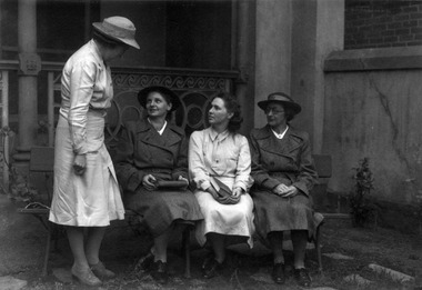
The 'Melbourne District Nursing Society After Care Home' was built by MDNS in 1926 and the name changed from 'Care' to 'Hospital' in 1934. It was located at 45 Victoria Parade, Collingwood. This photograph is taken three years after Miss Dorothy Tupper was appointed Matron of the District Nursing Division of the Society in 1941. The Sisters in this Division worked in the community giving nursing care to people in their own homes.From its foundation in 1885 the Melbourne District Nursing Society (MDNS, were instrumental in giving care to their patients, and to assist them if they had financial problems or resided in poor living conditions. Miss Dorothy Tupper, who as a Trained nurse, had undertaken a course in hospital housekeeping at London Prince of Wales Hospital, was contacted by MDNS in 1939 and, possessing both business and humanitarian qualities, was asked to organize their newly established Social Service Department. As the MDNS Social Service Sister, she assessed the living conditions in patient's homes. She continued in this role until being appointed Matron of the Society's District Nursing division in 1941. Matron Dorothy Tupper announced her retirement in December 1962. As Matron for 22 years she played a major role in the employment and management of an ever increasing nursing workforce as well as help oversee the expansion of the service. Matron Tupper was known for her keen sense of duty, her high professional standards and never-failing concern for patients. The photograph was taken by Sun Newspaper photographer and appeared in an article about the MDNS in September 1944Black and white photograph showing Melbourne District Nursing Society (MDNS) Matron, Dorothy Tupper, standing side on, and to the left, of three District Trained nurses (Sisters) who are seated in the grounds of the After-Care Hospital. Matron Tupper is wearing a light coloured uniform which has a belt and a centre box pleat on the lower part of the skirt; a grey brimmed hat with a darker grey hat band sits over her short dark hair. She is looking down at the first Sister on the seat who is looking up at her. The Sisters at either end of the seat are wearing dark grey double breasted coats with lapels; the collars of their light colour uniforms can be seen. Both are wearing grey brimmed hats over their short dark hair. The Sister at the far end is wearing glasses and the Sister near Matron Tupper is holding a book. The centre Sister has shoulder length dark hair and is wearing a light coloured long sleeve uniform. She is also holding a book. Both these Sisters are looking toward Matron Tupper. The seat is made of wood and is against the concrete veranda of the building behind. Scrolled metal lace work is directly behind them with a round thin concrete post to the left of Matron Tupper and the other end of the lace work is fixed to the concrete square corner columns. One turns to the right and the concrete wall of the veranda attached can be seen running in front of part of the brick wall of the building.after- care hospital, melbourne district nursing society, mdns, nurses, matron, mdns social service department, rdns, royal district nursing service, matron dorothy tupper -
 Royal District Nursing Service (now known as Bolton Clarke)
Photograph - Photograph, black and white, c.1960
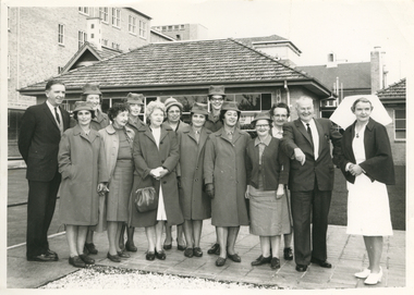
The occasion of the photograph is unknown, but it depicts a group of Melbourne District Nursing Service (MDNS) Sisters with Matron Tupper. She is wearing the Matron uniform of a white frock and veil and a red cape. The Sisters are wearing their grey MDNS uniforms and one is wearing a uniform red cardigan. The Sisters peaked hats have a red Maltese cross applied in the centre front.From its foundation in 1885 the Melbourne District Nursing Society (MDNS), were instrumental in giving nursing care to patients in their own homes, and to assist them if they had financial problems or resided in poor living conditions. Miss Dorothy Tupper who, as a Trained nurse, had undertaken a course in hospital housekeeping at London Prince of Wales Hospital, was contacted by MDNS in 1939 and, possessing both business and humanitarian qualities, was asked to organize their newly established Social Service Department. As the MDNS Social Service Sister, she assessed the living conditions in patient's homes. She continued in this role until being appointed Matron of the Society's District Nursing division in 1941; a role she continued in until her retirement at the end of 1962.Black and white photograph of a group of seven Melbourne District Nursing Service (MDNS) Sisters and Matron Tupper with two men and four ladies standing in two rows in front of a brick house which has a tiled roof. To the left in the back row is a gentlemen with dark hair, who is wearing a dark suit, then two MDNS Sisters, next is a lady who is wearing glasses and is dressed in a light colour coat and hat. To her right is a tall MDNS Sister wearing dark rimmed glasses, then a lady with dark curly hair looking over the shoulder of a man with grey hair who is wearing a dark suit; on his right is Matron Tupper, who is wearing her white nursing uniform, her dark cape, and white veil over her short dark curled hair. In the left front is a Sister; to her right is a lady with dark curly hair and wearing a light coloured coat over a dark skirt and jumper; then a lady with blonde curly hair who is wearing a dark coat over her light dress and is carrying a handbag. Three Sisters are to her right - the end one is wearing glasses and a dark cardigan over her grey uniform frock The other MDNS Sisters in the group are wearing their grey uniform coats over their partly seen grey uniforms. All the MDNS Sisters are wearing grey uniform peaked hats. A three storey building is to the left rear of the photograph and and parts of three other buildings behind and to the right of the house.melbourne district nursing society, mdns, mdns social service department, mdns matron, matron dorothy tupper -
 Royal District Nursing Service (now known as Bolton Clarke)
Photograph - Photograph, black and white, Barry Sutton, 17.10.1973
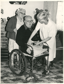
RDNS Sr. Clare McHugh is attending Mr. Stevenson in his home to give him nursing care. She is about to fasten the wheelchair safety belt across Mr. Stevenson's lap to ensure he does not fall out of the wheelchair. The Trained nurses (Nurses) of the Melbourne District Nursing Society (MDNS), later known as Royal District Nursing Service (RDNS), visited patients in their home and gave best practice care in many fields of nursing, and to people of many cultures, throughout its 130 years of expansion. Initial visits not only assessed the specific nursing situation but the situation as a whole. The RDNS Trained nurses (Sisters) visited patients from many different cultural backgrounds, and Education was given to their Sisters to assist them when speaking with the patients and giving them care. Their patients ranged in age from babes, children, adults to the elderly and referrals were taken from Hospitals, General Practitioners and allied Health facilities. Some of the care the Sisters provided is as follows: – Post-Natal care given to mother and babe, Wound Care following various types of surgery, accidents, burns, cancer, leg ulcers etc. Supervising and teaching Diabetic Care, including teaching and supervising people with Diabetes to administer their own Insulin, and administering Insulin to those unable to give their own injections. Administering other injections and setting up weekly medication boxes. The Sisters performed Catheterizations on adults suffering from conditions such as Quadriplegia, Paraplegia, Multiple Sclerosis (MS), Motor Neurone Disease (MND) and Guillan-Barre Syndrome, and when required at school on children for e.g. those with Spina Bifida. The Sisters visited those requiring Cystic Fibrosis support and care; those requiring Haemo-Oncology care, including visiting children at school; those requiring Home Enteral Feeding care, and those requiring IV therapy at home and home Dialysis. Palliative Care was given including pain relief with the use of syringe drivers, personal care as needed, and advice and support to both patient and family. The Sisters provided Stoma management to those needing Urostomy, Ileostomy and Colostomy care and those requiring Continence care. HIV/AIDS nursing care was provided; visits to Homeless Persons were made. Personal care was given to patients ranging in age and with varying mobility problems, such as Amputees, those with MS, MND, Guillan-Barre Syndrome, Poliomyelitis, Quadriplegia, Paraplegia, Acquired Brain Injury, to those following a Cerebrovascular Accident (Stroke), those with severe Arthritis and those with a form of Dementia. When necessary the elderly were assisted with personal care and advice given on safety factors with the use of hand rails, bath or shower seats, and hand showers. Rehabilitation with an aim towards independence remained at the forefront of the Sister’s minds and when possible using aids and instruction on safe techniques enabled the person to become fully independent. All care included giving advice and support to the patient and their Carers. The Sisters liaised with the persons Doctor, Hospital and allied Health personal when necessary. In the centre of this black and white photograph is Mr. Stevenson, an elderly gentleman, who has balding light hair; is wearing dark rimmed glasses, and is wearing a black cardigan over a grey shirt. A small amount of his grey trousers can be seen. He is sitting in a wheelchair and is looking at the camera. He has a light coloured small blanket tucked under and over the stumps of his above the knee amputated legs. Standing behind his chair, and slightly to his left, is a lady who is wearing glasses; has wavy light grey hair and is wearing a dark grey cardigan over her light coloured patterned frock. Her right hand is seen holding the handle of the wheelchair, and she is looking down at Mr. Stevenson. To the right is Sister Clare McHugh of Royal District Nursing Service (RDNS), who is slightly bent as she has her hands on the left and right sides of the safety belt across Mr. Stevenson's lap. The belt is attached to either side of the wheelchair. Sr. McHugh has straight blonde hair; only part of her face can be seen as she looks at Mr. Stevenson. She is wearing a white gown over her uniform. In the left background is part of a brick fireplace with wood mantelpiece. A patterned plate and dark items are on the left of the mantelpiece and flowers are seen on the right. Above this, part of a square mirror can be seen. To the right, part of a lounge chair is seen and behind this, an open check curtain and part of a voile curtain is seen. The floor is covered with a light and dark patterned carpet.Barry Sutton LW 6 Namesroyal district nursing service, rdns, rdns nursing care, rdns physiotherapy, sister clare mchugh, mr stevenson -
 Eltham District Historical Society Inc
Photograph - Digital Photograph, Marguerite Marshall, Rice House, 69 Ryans Road, Eltham, 27 March 2007
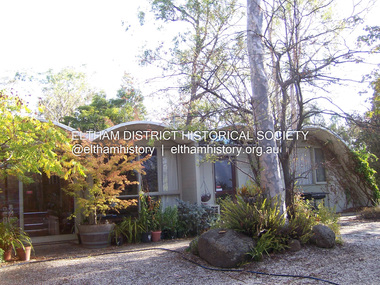
Built in 1953, the Rice House was leading Melbourne architect Kevin Borland's first commssion and was one of two houses of its kind. The design of the shell-like structure was inspired by the Arch of Ctesiphon, built in the second century south of Baghdad. Cement with a waterproofing agent was applied in layers to a form of regularly spaced timber arches covered in hessian. This ctesiphon system was developed in the United Kingdom by engineer J.H. de Waller in 1947. Commissioned in 1951 by Harrie and Lorna Rice, after Harrie, then an art student, met Borland at The Age Small Homes Service. Borland suggested they buy land in Eltham because at that time it was the only council in Melbourne that would grant a permit for such an innovative house. Covered under Victorian Heritage. Published: Nillumbik Now and Then / Marguerite Marshall 2008; photographs Alan King with Marguerite Marshall.; p157 Inspired by an ancient arch in Iraq, a house stands on top of a hill in a private position, off Ryans Road, Eltham. One of only two houses of its kind, it was leading Melbourne architect Kevin Borland’s first commissioned house, which he built in 1953. The shell-like structure, partially screened by giant trees and cacti, was inspired by the Arch of Ctesiphon south of Baghdad, built in the second century.1 Cement with a waterproofing agent was applied in layers to a form of regularly spaced timber arches tightly covered by hessian. This ctesiphon system was developed in the United Kingdom by engineer J H de Waller in 1947. This house was the first of three such structures built in Victoria, of which only one other remains, although substantially altered.2 It is the Wood House and supermarket, at the corner of Cleveland Road and High Street Road, Ashwood, designed by Robin Boyd in 1952. The Rice House demonstrates Kevin Borland’s innovative and experimental work. It is an outstanding example of the post-war period of experimentation in domestic architecture in Melbourne – by Robin Boyd, Kevin Borland and others – for The Age Small Homes Service from 1947 to 1953. This was partly an expression of late-Modernism and also necessitated by the post-war shortage of building materials. In Eltham, the post-war shortage of building materials largely resulted in mud-brick houses. Examples of Borland’s public work include contributions to the Olympic Swimming Pool in Melbourne and the Preshil Junior School in Kew. After more than 50 years of living in the house, Harrie and Lorna Rice still love it. Facing north-east with large windows overlooking the garden and two courtyards, it is well lit and benefits from a through breeze. The couple commissioned the extraordinary house after Harrie, then an art student, met Borland in 1951 at The Age Small Homes Service. Harrie was so impressed by the recently graduated Borland’s enthusiasm, that he asked him to design them an interesting house for a low budget.3 The unusual design presented several hurdles for the young couple before they could construct it. Borland suggested that they buy land in Eltham, because at that time it had the only council in Melbourne that would allow such an innovative house. Another hurdle was to gain finance for this remarkable house. The State Savings Bank Manager refused finance on the grounds that it was ‘unliveable’ and a ‘disgrace’. Fortunately, through a family connection, the couple borrowed money from the National Bank. But they discovered years later, that the bank’s evaluation stated the two ‘concrete sheds’ were of no value!4 The house built in off-white concrete, consists of two sections. The main house has four arches supported by brick and concrete walls that create a series of inter-connected rooms. Inside, the ceiling follows the roofline. Originally this section was only ten square metres, because of building restrictions at the time. But in 1973 Borland added two rooms and a carport. The second structure of two arches was originally a garage and a studio for art teacher Harrie Rice. To accommodate the growing family, in the mid 1950s, Borland converted the second structure into two children’s bedrooms, a kitchenette, a bathroom and a living room. The two structures were originally linked by a covered way of suspended draped-concrete, but this collapsed in the 1980s. The design has several maintenance problems. Cracks developed where two halves of the shells were joined. Then the material sprayed over the cracks became brittle, causing leaks. Fortunately Harrie found another material he could use. The valleys between the arches collect water, requiring annual painting with a waterproof material to prevent leaking. Lorna framed the house with native and exotic plants, which provide privacy and as a bonus, the garden attracted the rare Eltham Copper Butterfly.This collection of almost 130 photos about places and people within the Shire of Nillumbik, an urban and rural municipality in Melbourne's north, contributes to an understanding of the history of the Shire. Published in 2008 immediately prior to the Black Saturday bushfires of February 7, 2009, it documents sites that were impacted, and in some cases destroyed by the fires. It includes photographs taken especially for the publication, creating a unique time capsule representing the Shire in the early 21st century. It remains the most recent comprehenesive publication devoted to the Shire's history connecting local residents to the past. nillumbik now and then (marshall-king) collection, eltham, rice house, ryans road -
 The Beechworth Burke Museum
Photograph - Lantern Slide, c1900
This glass slide presents an image of the Old Beechworth Post Office and was taken in the year 1900. The building displayed within the image is not that of the post office in its original form; the post office originally consisted of only a simple wooden building. With the establishment and growth of new towns across Victoria, as well as an increased need for more consistent communications with the City of Melbourne, this modest building was soon deemed inadequate. In 1858 it was brought into the style of the changing times, with the tall clock tower added in 1865. This transition aligned with a pattern of refurbishment and conversion of many Beechworth buildings (which could be seen during the 1860s-70s), aiding in the growth and prosperity of the town. Early makeshift homes were turned into more substantial dwellings, featuring elements such as weatherboard, brick, and granites materials, and gabled or hipped roofs with iron lacework fringing the verandah. These refurbishments were temporarily halted in March of 1867 when a fire swept through the town, damaging many buildings including the post office. This led to further reconstructions on the building, including heightening of the clock tower, and in 1870 the two-storey Italianate style building was completed. The Old Beechworth Post Office itself also holds significance due to its connection with one of Australia's most infamous families. It reportedly played an important role in communicating the news of the 1880 murders of police at Stringybark Creek by the Kelly Gang. Lantern slides, sometimes called 'magic lantern' slides, are glass plates on which an image has been secured for the purpose of projection. Glass slides were etched or hand-painted for this purpose from the Eighteenth Century but the process became more popular and accessible to the public with the development of photographic-emulsion slides used with a 'Magic Lantern' device in the mid-Nineteenth Century. Photographic lantern slides comprise a double-negative emulsion layer (forming a positive image) between thin glass plates that are bound together. A number of processes existed to form and bind the emulsion layer to the base plate, including the albumen, wet plate collodion, gelatine dry plate and woodburytype techniques. Lantern slides and magic lantern technologies are seen as foundational precursors to the development of modern photography and film-making techniques. This glass slide captures social and historical significance as it displays the Old Beechworth Post Office in 1900, a building that demonstrates the prosperity and growth of Beechworth as a town during this time period. This slide also holds a level of aesthetic significance due to the Italianate style building that is featured in its image; a style that became very popular during the nineteenth-century. Thin translucent sheet of glass with a square image printed on the front and framed in a black backing. It is held together by metal strips to secure the edges of the slide.Obverse: x / burke museum, beechworth, lantern slide, slide, glass slide, plate, burke museum collection, photograph, monochrome, beechworth post office, beechworth post office kelly gang, 1900, 1900 beechworth, growth of beechworth, 1867 beechworth fire, old beechworth post office, beechworth post office reconstructions, italianate style, italianate style buildings, italianate style beechworth post office -
 Eltham District Historical Society Inc
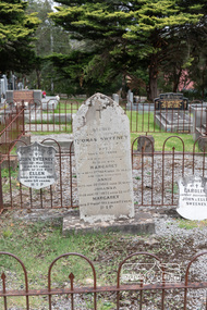
Photograph, Peter Pidgeon, Graves of Thomas Sweeney and family, Eltham Cemetery, Victoria, 5 April 2021
Irish-born Thomas Sweeney is regarded as the first settler in Eltham. He was transported to Sydney in 1823 after being convicted of arson. He was granted his freedom in 1838 and married Margaret Meehan in the same year. They moved to Melbourne and in 1842 Thomas purchased 110 acres beside the Yarra River in the vicinity of present-day Sweeneys Lane. He called the property ‘Culla Hill’ and built a small slab hut (reputedly with Wurundjeri help; Margaret is said to have run an informal hospital for them in return). This was followed in 1846 by more substantial buildings consisting of a three-roomed Irish-style ‘longhouse’ and a barn made of stone and handmade bricks, with doors large enough to accommodate a fully loaded wagon. When the gold rush came, Thomas prospered by selling meat and potatoes to the prospectors, enabling him to purchase a further 308 acres in 1856. He promoted the construction of a bridge over the Plenty River and the establishment of a school at Eltham. Roman Catholic Church services were held at Culla Hill in the early years. When he died in 1867, he was regarded as a respected member of the community. Thomas and Margaret are buried in Eltham Cemetery with many of their descendants. Their first son John continued to farm Culla Hill until his death in 1909. Culla Hill passed out of the Sweeneys' possession in 1939. The house and barn remain today, though lesser outbuildings have gone. The facade of the house is much the same as it was in the 1840s. Sacred To the memory of Thomas Sweeney Who died Sep 6th 1867 Aged 65 years May his soul res in peace Also his wife Margaret Died Oct 3rd 1884 aged 73 years And their daughters Annie Died Aug 22nd 1860 aged 21 years Johanna Died Aug 19th 1872 aged 22 years Margaret Died 7th Sep 1913 aged 72 years R.I.P. Also In Memory Of John Sweeney Died 24th May 1909 Aged 65 years Also of his wife Ellen Died 8th March 1910 Aged 64 years R.I.P Also In Memory Of Caroline Infant daughter of John & Ellen SweeneyBorn Digitalannie sweeney, eltham cemetery, gravestones, johanna sweeney, john murray, margaret sweeney, mary ellen drain, mary murray, thomas drain, thomas sweeney -
 Eltham District Historical Society Inc
Photograph, Fay Bridge, Clifton Pugh's Artists' Colony, Dunmoochin, Barreenong Road, Cottles Bridge, c.1995
Visit to Dunmoochin prior to Clifton Pugh's home being destroyed by fire in 2002. Following military service in the second world war, Clifton Pugh studied under artist Sir William Dargie at the National Gallery School in Melbourne as well as Justus Jorgensen, founder of Montsalvat. For a while he lived on the dole but also worked packing eggs for the Belot family saving sufficient to purchase six acres (2.4 ha) of land at Barreenong Road, Cottles Bridge. He accumulated more land and persuaded several other artists and friends to buy land nearby, resulting in a property of approximately 200 acres, stablishing it as one of the first artistic communes in Australia alongside Montsalvat in Eltham. It was around 1951 that Pugh felt he had '"done moochin' around" and so the name of the property evolved. He bought timber from Alistair Knox to build his house on the crest of a hill. Inspired by local goldminer's huts, it was a one room wattle-and-daub structure with dirt floor. Over the years it expanded with thick adobe walls made from local clay, high ceilings and stone floors. All materials other than the local earth were sourced from second hand materials, most found at wreckers' yards. Artists from across the nation were drawn to Dunmoochin, with several setting up houses and shacks on the property, maintaining their independence but sharing their artistic zeal. Artists who worked or resided at Dunmoochin included Mirka Mora, John Perceval, Albert Tucker, Fred Williams, Charles Blackman, Arthur Boyd and John Olsen. In 2002, Pugh's house along with its treasure trove of art and a library of some 20,000 books was destroyed by fire. Traces of Pugh's home remain with the presence of the Victorian doorframe archway with leadlight of intricate design, procured from a demolished Melbourne mansion; and two bronze life-sized female statues created by Pugh and cast by Matcham Skipper. In place of Pugh's house rose two double-storey mud-brick artists' studios topped with corrugated iron rooves curved like the wings of a bird with accommodation for seven. The original studios, gallery and other buildings survived the fire.fay bridge collection, 1995, barreenong road, cottles bridge, dunmoochin -
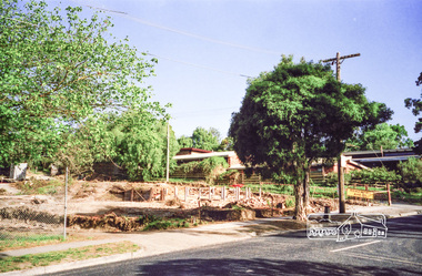
 Eltham District Historical Society Inc
Photograph, Clearing land for Le Pine Funeral Home, cnr York Street and Main Road, Eltham, c.March 1998, 1998
Newsletter No. 116, September, 1997 846-848 MAIN ROAD ELTHAM Nillumbik Shire Council has granted a permit for a funeral parlour on land which includes this site at the corner of Main Road and York Street. The site contains an architect's office in a building which was formerly a shop and dwelling dating from the 1920's. The proposal requires demolition of this building which is one of the few remaining old shops which formed the rather spread out "town centre" of Eltham. Prior to making its decision the Council obtained a report from Graeme Butler and Associates, the heritage consultants who carried out Stage 1 of the Nillumbik Heritage Study. The report summarized the historical significance as follows:- "This brick comer shop with associated residence has potential local historical significance as a late 1920's grocer's shop, now much altered and one of only a few shops of that era left in Eltham's Main Road. This significance is qualified by the many changes. The other examples are better preserved and still function as shops." With this type of expert advice it is difficult to make a strong case for preservation of the building although, of course, it is a shame to see it demolished. The report includes details of the site itself and its history based on research carried out by Carlotta Kellaway. The building dates from the late 1920's when it was owned by C.R. Nicholls. From the early 1930's it was Charles Cockroft's grocery shop and he also ran a grain store there. According to his daughter, Edna Brown, he delivered groceries around the district taking his truck as far as Kangaroo Ground. In 1950 he shifted to Traralgon. Since then several different businesses have operated from the site including a bottle merchant and produce store. Conversion to the present office use involved alterations to the shop front and rebuilding the galvanized iron store at the rear. Newsletter 119 March 1998 In our Newsletter No. 116 it was reported that the former shop on the comer of Main Road and York Street, Eltham was to be demolished as part of a funeral parlour development. If you have passed the site recently you will have noticed that it has now been demolished - another part of the old Eltham township has disappeared.Roll of 35mm colour negative film, 6 strips Also photographic prints 10 x 15 cmKodak Gold 200-6a.r. warren, eltham feed store, le pine funeral home, main road, york street, c.r. nicholls, charles cockcroft, grocery store -
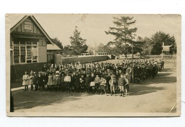 Orbost & District Historical Society
black and white photograph, C 1922
DESCRIPTIONA black / white photograph on a grey buff cardboard frame. It is of a group of students standing outside the Orbost State School building. One child holds a sign reading "Form F". There is a photographer's label at the bottom.SIZEH-199mm W-028mmOBJECT REGISTRATION890KEYWORDSeducation-orbost orbost-state-schoolHISTORICAL INFORMATIONThe 19th of March 1886 proved an important day in the lives of many early settlers in the Orbost area, because on this day the Orbost State School opened. The fact that the school had first operated temporarily in a leased building, and on a half-time basis with SS2745 Jarrahmond, did not dampen the enthusiasm of the local inhabitants as they saw their offspring commence their education under the guidance of HT Campbell Mackay. However he remained in charge only until 12th of May 1886. The second HT, John Rowe, served until 1908. On 30th of June 1887, a portable room was provided; it being brought to the area by schooner. The school now had accommodation for 30 pupils; the teacher's welfare was considered because quarters of two rooms were attached. As the population increased so did the needs of the school. This was reflected in the provision of a larger classroom in 1898. During 1910-11 the first approaches were made to the Department for the establishment of a HES in Orbost and this became a reality in 1912. Orbost HES supplied post-primary education in the district until a high school was built in 1948. When fire destroyed the school in 1941 local halls were used as classrooms until a new school was built. Work was quite rapid and a new brick structure was opened by the Hon. A. E. Lind, MLA, on 13th of February 1942. This new building was a fine type of school of which both the pupils and the HT Leslie Collins were indeed proud. But Orbost continued to develop and the new school was soon overtaxed. This resulted in the erection of two Bristol classrooms in 1947. By 1950, when the school population had reached 500 pupils the opening of the new school at Orbost North was welcomed by all concerned. In 1963 the Department purchased land diagonally opposite the school and developed it as a playing area. In 1965 two LTCs were opened in November, and in October 1968 the Brodribb School building was moved to SS2744 Orbost for use as a general purpose room. ( Info. from Schools East Gippsland)This item is associated with the history of education in Orbost.A black / white photograph of a large group of children standing outside a school building - " Orbost State School No. 2744". The younger students are standing in the front. High School students are at the back.on back - "Mr C. Connor S.M. Mr Tipper H.M. State & H.E.s. about 1922"education-orbost orbost-state-school orbost-higher-elementary-school -
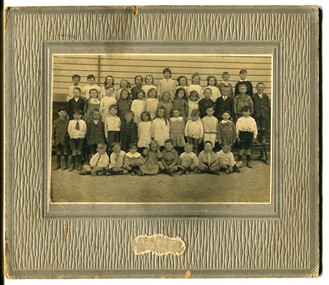 Orbost & District Historical Society
black and white photograph, C 1920
Phyllis May Waller was born Orbost in 1912. Her father-was Frank Hale Waller and her mother -Sarah Elizabeth Clancy. Phyllis married Clive Howell Crawford Pasco in 1934 (Clive was born 1908 at Prahran, and died in 1971 at South Melbourne). "The 19th of March 1886 proved an important day in the lives of many early settlers in the Orbost area, because on this day the Orbost State School opened. The fact that the school had first operated temporarily in a leased building, and on a half-time basis with SS2745 Jarrahmond, did not dampen the enthusiasm of the local inhabitants as they saw their offspring commence their education under the guidance of HT Campbell Mackay. However he remained in charge only until 12th of May 1886. The second HT, John Rowe, served until 1908. On 30th of June 1887, a portable room was provided; it being brought to the area by schooner. The school now had accommodation for 30 pupils; the teacher's welfare was considered because quarters of two rooms were attached. As the population increased so did the needs of the school. This was reflected in the provision of a larger classroom in 1898. During 1910-11 the first approaches were made to the Department for the establishment of a HES in Orbost and this became a reality in 1912. Orbost HES supplied post-primary education in the district until a high school was built in 1948. When fire destroyed the school in 1941 local halls were used as classrooms until a new school was built. Work was quite rapid and a new brick structure was opened by the Hon. A. E. Lind, MLA, on 13th of February 1942. This new building was a fine type of school of which both the pupils and the HT Leslie Collins were indeed proud. But Orbost continued to develop and the new school was soon overtaxed. This resulted in the erection of two Bristol classrooms in 1947. By 1950, when the school population had reached 500 pupils the opening of the new school at Orbost North was welcomed by all concerned. In 1963 the Department purchased land diagonally opposite the school and developed it as a playing area. In 1965 two LTCs were opened in November, and in October 1968 the Brodribb School building was moved to SS2744 Orbost for use as a general purpose room."This item is associated with the history of education in Orbost. It is also associated with the Waller family, early settlers in Orbost.A black / white photograph on grey card. Against a wooden building are four rows of young children. The front row of the youngest children is sitting with crossed legs.The back three rows are tiered. the children appear to be dressed in their best clothes with many of the boys wearing ties. There is a photographer's label at the bottom.on back written by older son -"Orbost State School Approx. 1920 Mum (Phyllis May Waller) 6th from left 2nd back row"waller-phyllis-may -
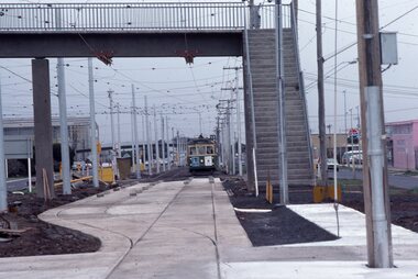 Melbourne Tram Museum
Photograph - Last day of original Essendon Airport tram terminus, Ron Scholten, 7-10-1976
The original line to the Essendon Aerodrome was constructed in 1943 to serve the airport and aircraft construction. It was funded by the Commonwealth Government. By 1976, patronage to the airport terminus in Vaughan St had dropped, the crossing of the highway to the Tullamarine Airport opened in 1970, was dangerous, and the highway needed to be widened. The new terminus was a short distance to the north between Mathews Ave and the Highway. This series of photographs show the last day of operations to the original terminus and the changeover, which was done in about 7 hours. No buses were required. It was done by workers of the Melbourne and Metropolitan Tramways Board. The line was later extended to Airport West. .1 - W5 789, (Essendon Airport Route 59) about to turn from Mathews Ave into Vaughan St. Has new track and footbridge in the foreground. .2 - W5 791 on the siding or spur at the airport terminus, the last tram to use this facility. .3 - W2 571, at the Airport terminus alongside Vaughan St on the last morning of the use of this terminus. The Bundy clock can be seen behind the pole on the lefthand side and the Brick passenger shelter. Shows buffer stops, and Forestair hanger behind. .4 - W2 595 turning from Vaughan St into Mathews Ave. Has the tram stop No. 55 in the view. .5 - W5 839 turning from Vaughan St into Mathews Ave. Shows the flashing yellow light that gave some protection to the trams. .6 - W2 247 about to turn into Vaughan St. Driver about to reboard the tram. Note the new copper trolley wire is up for the new track but has been pulled to the west side using rope. .7 - W5 805, turning from Mathews Ave into Vaughan St, to the old Essendon Airport terminus. Has a new track in the foreground, and the overhead for the curves is still in position. .8 - W6 991 turning from Vaughan St into Matthews Ave, at 855am, the last tram from the old terminus. The track gang has commenced work to remove the outbound curve. Would appear four passengers waiting at the tram stop, two with lunch bags. Note the cattle grid in the foreground between the rails. New rails on the ground on the left-hand side. See Reg Item 6163 for further photos of this event.Yields information about the last day of the operation of the original Essendon Airport tram line.Set of 8 Kodachrome cardboard mount colour slides of the relocation of the Essendon Airport tram terminus 7-10-1976, by Ron Scholten.All slides have detailed descriptions on the reartrams, tramways, essendon aerodrome, essendon airport, closure, new tramways, route 59, w5 789, w5 791, w2 571, w2 595, w5 839, w2 247, w5 805, w6 991, w2 class, w5 class, w6 class, mmtb, trackwork -
 Stawell Historical Society Inc
Photograph, Pioneer Walk Murals
27 colour photographs of the Pioneer Walk Mural displayed in Town Hall in 16.04.1992 prior to being installed in the "Pioneers Walk". Photos 322 - 12 to 14 shows the Pioneers walk way before a roof was placed over the walk way. The mural has been replaced. 322 Opening in Town Hall 16.04.1992, Wayne Kayler Thompson Mayor Cr. Bob Stone & Mrs Stone. 1. Opening speeches in Town Hall. Shire Councillor Laurie Delahunty & Marjory Delahunty. 2. Unveiling by project coordinator Jenny Munro. 3. First opening Town Hall 16.04.1992. This section of Mural was above entrance to Main Street. 4. First opening Town Hall 16.04.1992. 5. Another detail mural taken at Town Hall opening. 6. Mural detail 16.04.1992. 7. Photo of Bill Walker on left featured in Mural. 8. Opening in Town Hall. Mark Dadswell Times news Photographer. Herb Skurrie is featured in Mural & Helen Leach. 9. First opening, putting away at Town Hall. 10. Opening Town Hall 16.04.1992. 11. Detail of mural at opening 16.04.1992. 12. Another detail of boulders and steps in mural. Opening Town Hall. 13. Mural detail. 14. Mural on brick wall with Cate Whitehead, Jenny Munro and Peter Whitemead. 15. Mural detail opening Town Hall 16.04.1992. 16. Mural detail showing town hall drawing at first opening in Town Hall 16.04.1992. 17. Mural detail. 18. Detail in Mural at Town Hall opening 16.04.1992. 19. Edge of mural detail at Town Hall opening. 20. Lower detail of 322 (19) mural in Town Hall. 21. Mural detail Dedicated to the Pioneers of Stawell and Districts. Town Hall opening. 22. Mural detail displayed at Town Hall opening 16.04.1992. 23. Mural detail showing domestic scene and map of Stawell area at Town Hall opening. 24. Mural detail 1st opening at Town Hall. 25. Scene on mural show at 1st opening at Town Hall. 26. Photo showing one end of mural at 1st opening at Town Hall. 26 colour photographs of the pioneer walk "Murals"stawell -
 Eltham District Historical Society Inc
Photograph - Digital Photograph, Marguerite Marshall, Wingrove Cottage, Main Road, Eltham, 8 June 2006
Wingrove Cottage built 1858-1859 of hand made bricks is historically significant for its long association with Charles Wingrove, a prominent figure in Victorian local government, as secretary to the Eltham District Road Board and Shire Council from 1858 to 1904, and Shire Engineer and Secretary to the Heidelberg Road Board. The cottage was used as the office of the Eltham District Road Board and Council for many years It is one of the Shire's oldest dwellings, and one of the few surviving 19th century buildings associated with early Eltham and located in the original Eltham Village Reserve. The symmetrical planting of a pair of Pencil Pines (not visible in photo) is also historically and aesthetically significant as characteristic of the early period of planting in the district and because they are a distinctive landscape feature. In October 2002 new owners demolished the outbuildings attached to the rear of the cottage. Community protest at the demolition resulted in Council issuing a Stop Work order. The owner was issued with a court order in September 2003 to develop a conservation management plan and restore the heritage listed property. The owner sold the property in 2005 to Cameron Construction in 2005 who undertook the restoration work. In 2007 a planning application to build two offices and seven dwellings at the rear of the property was ultimately rejected. The cottage is now the main office for Cameron Construction. Covered under Heritage Overlay, Nillumbik Planning Scheme. Published: Nillumbik Now and Then / Marguerite Marshall 2008; photographs Alan King with Marguerite Marshall.; p57 Wingrove Cottage on Main Road beside Eltham Primary School, is one of the Shire’s most important historical buildings and was central to local government for almost 50 years. The cottage was built in stages from 1858 to 1888 for Charles Symons Wingrove JP. He was the Eltham District Road Board’s first paid secretary and later the Shire Secretary when the board became the Eltham Shire Council. Wingrove held those positions, and that of engineer for a time, for 46 years. He was also one of the main figures in the Municipal Association of Victoria. As Eltham’s first paid municipal officer, Wingrove used one room in his 11 – (originally two) roomed home, as the office for the board then the council. Meetings were held there from the late 1850s (as well as at more central locations) until Wingrove’s retirement in 1904. The cottage is a rare example of a local government office occupying a Road Board /Shire Secretary’s purpose-designed house. The cottage is also significant because it is the oldest largely intact building from the original Eltham township reserve (south of Dalton Street).1 The township had its origins in the 1848 Nillumbik Parish Plan and was one of the state’s earliest township reserves. The rectangular house of handmade bricks, roofed with grey slate tiles and with a veranda encompassing three sides, is reminiscent of those in the central goldfields including Castlemaine. Its overhanging eaves and gables were unlike houses in Melbourne at the time. Wingrove, who was born in 1827, had been a gold digger and a road surveyor. Impossible to imagine in today’s world, Wingrove was also the Shire of Heidelberg’s secretary and engineer for part of the time that he was secretary in Eltham. Living next door to the primary school was a mixed blessing. Wingrove and his wife Katherine, who had ten children, sent their eight surviving children to the school. But they had occasional disputes with the school authorities when their cattle wandered into the schoolyard. Eltham showed Charles Wingrove its appreciation of his services by giving him two illuminated addresses, one after ten years and the other at retirement. Wingrove died in 1905 aged 76 and was buried in the St Katherine’s Church of England cemetery in St Helena. His grave is surrounded by those of family members including his wife, Katherine and two babies, Henry, 12 months and Isobella, 15 months, who died in the mid-1860s. Cottage ownership passed to his wife, then to daughter Caroline and then to daughter Bessie, a Melbourne University graduate and artist. During the Great Depression their brother Walter was the ratepayer. At one stage the Wingrove property extended to Metery Road and included a small creek. The family ran a small dairy and orchard, with associated farm buildings, which were later removed. In 1949 part of the property was compulsorily acquired by the Eltham Primary School, which infuriated owner Bessie Wingrove. She protested in a letter about this ‘monstrous act of unmitigated tyranny’.2 She was the last Wingrove to occupy the cottage and died in 1955. Wingrove descendants sold the house in 1974 and the property was subdivided. In the 1960s the Eltham Shire named the park opposite the cottage in Wingrove’s honour. The cottage has since had several owners including psychiatrist Dr Daniel Kahans, who practised there. In October 2002 late rear additions which had been substantially altered were demolished contrary to council planning controls. This caused a community outcry and resulted in legal proceedings against the owner. Fortunately the historical significance of the demolished section was not as great as the older front part of the building, which has been retained and was later restored.This collection of almost 130 photos about places and people within the Shire of Nillumbik, an urban and rural municipality in Melbourne's north, contributes to an understanding of the history of the Shire. Published in 2008 immediately prior to the Black Saturday bushfires of February 7, 2009, it documents sites that were impacted, and in some cases destroyed by the fires. It includes photographs taken especially for the publication, creating a unique time capsule representing the Shire in the early 21st century. It remains the most recent comprehenesive publication devoted to the Shire's history connecting local residents to the past. nillumbik now and then (marshall-king) collection, cameron construction, charles symons wingrove, eltham, eltham road district board, eltham shire council, main road, wingrove cottage