Showing 15183 items
matching country%20womens%20association%20of%20victoria
-
 Flagstaff Hill Maritime Museum and Village
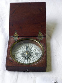
Instrument - Compass, c. 1839
This magnetic compass is a good size to fit easily into a person's pocket or personal luggage and is protected from knocks by its wooden case. It could have been used for reference when travelling on land or sea. There is no visible manufacturer's mark, which may mean that it was not of high monetary value. Leith is a district of Edinburgh in the country of Scotland, the U.K. It was once the Port of Edinburgh and many migrant ships departed from here bound for the Australian colony. It had a busy shipbuilding industry, with wet and dry docks. It appears from the inscription on the case "Chas Gray, LEITH, 1839" that this pocket compass once belonged to Charles M. Gray (Chas is a common abbreviation for the name Charles). The inscription coincides with the name, place and date that the Western Victorian pioneer Charles M. Gray left Scotland and arrived in Australia. Charles Gray was born in Anstruther, Scotland, in 1818. His family was connected with the Royal Marines, which may have created his nautical instruments such as this pocket compass. Charles Gray arrived in Hobson's Bay on 15 June 1839 on the ship “Midlothian”. That same ship had departed from Leith, Scotland on February 15th 1839. Did Charles Gray acquire the pocket compass in Leith, perhaps as a gift or a souvenir of his motherland? Charles Gray was an early squatter and went on to become a very successful settler as a sheep pastoralist in the Western District of what is now Victoria (originally the colony of New South Wales). He and his wife had a large property called “Nareeb Nareeb”, Green Hill Creek District (now Glenthompson), Victoria, from 1840-1886. He was also a local Councillor and Justice of the Peace, and had an interest in the local indigenous people; he named his property after their tribe. Charles returned to England in 1890 and died there in 1905. Charles Gray had written an account in 1890 of his life at Nareeb Nareeb, called Western Victoria in the Forties: "REMINISCENCES OF A PIONEER The Western District in the 1840's By Charles Gray" , a valuable historical reference to colonial Victoria. His book was published by the Hamilton Spectator in 1932. Charles Gray's photograph is one of 713 historical photographs of early Victorian settlers, created as a montage by Thomas Foster Chuck in 1872. The State Library of Victoria holds the framed montage titled “The Explorers and Early Colonists of Victoria”. To qualify for inclusion on this montage the Settlers must have arrived in Victoria before 1843. Charles Gray's photograph is number 349! The pocket compass is associated with Charles Gray, one of the early squatters and settlers in Western Victoria, possibly given to him as a parting gift on his emigration to Van Diemans land in 1839. The item is very significant as it's connection with one of Victoria's early pioneers is well provenanced by the inscriptions on the wooden case. Pocket compass, brass, set into a square wooden case with hinged lid and small hook catch. Compass is marked with 360 degrees and compass points and has two pointers; one to show magnetic north and one to set the direction of travel. Hinges are triangular and inset into the wood. The lid has an attached brass plaque with the inscription "Chas Gray, Leith, 1839" (It likely belonged to Charles Gray, Leith, UK, who migrated to Port Philip Australia in 1839 and became a successful pastoralist.) “Chas Gray / LEITH / 1839” engraved on brass plaque on lid.flagstaff hill, warrnambool, shipwrecked coast, flagstaff hill maritime museum, maritime museum, shipwreck coast, flagstaff hill maritime village, great ocean road, magnetic compass, pocket compass, charles m. gray, chas gray, migrrant from leith 1839, charles gray anstruther, scottland, ship midlothian 1839, squatter western victoria, settler western victoria, hobson's bay port phillip australia, charles gray nareeb nareeb - green hill creek district, western victoria in the forties: reminiscences of a pioneer by charles m. gray 1890, leith edinburgh u.k., western victoria in the forties: reminiscences of a pioneer - montage by thomas foster chuck 1872, charles gray, reminiscences of a pioneer, the western district in the 1840's, compass, scientific instrument, nautical instrument, direction, directional compass, navigation -
 Flagstaff Hill Maritime Museum and Village
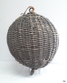
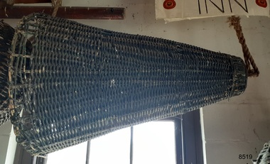
Equipment - Distant Signal, 1897-1931
This three-dimensional Distant Signal is part of a Flagstaff Signal set of ball, cone and drum shapes. It has been woven and then fabricated with strong metal swivel fittings and loops for suspending from a high point on a flagstaff at a signal station or on a ship’s masthead. The cane signal was constructed to withstand all weather and to be visible from a long distance. The gaps between the woven cane allow air to pass through, minimising possible swaying. Similar sets were made from rope or fabric. Warrnambool's Flagstaff was erected in 1854. Its primary use was to display visual signals that could convey messages between land and sea. It was also used to notify the local population of the approach of ships. One of the popular signalling codes in use in the early-to-mid 1800s was the Marryat’s Code but there were others in use as well; there was no one standard code. In 1857 the International Marine Conference adopted an International Code of Signals as a standard communications system for all vessels that could be understood in many different languages. The Normanby Advertiser reported on June 5th 1857 a query from the Post Master General as to whether the request of the Chief Harbour Master would be carried out, in that Warrnambool would receive a new flagstaff and a set of Marryatt’s signal flags. The Table of Codes was published, showing how to use combinations of these flags to send messages. The Code was revised in 1887 to cover situations where distance, light, wind and weather conditions affected the visibility of the flags and prevented clear communication. The first report of the International Code of Signals Committee of 1897 warned signalmen not to rely on ordinary semaphore flags and introduced a Distant Signal Code using either particular semaphore flags or the three-dimensional shapes of a ball, cone and drum that aligned with the semaphore flag shapes of a circle, pennant and square. International Code of Signals In 1931, after World War I’s experiences in using signal codes, the International Code of Signals conference in Washington revised and published the rules for the conduct of signalling. One of the changes was that “the use of the Distant Signals and of fixed semaphore was abandoned”. It is of interest to know that modern marine law in many countries insists that a set of Day Shapes must be carried onboard vessels of a certain size. These highly visible geometric shapes are used at sea in daylight to communicate messages between vessels. They are used in a similar way to the Distant Signals, in that different combinations of shapes represent different messages. The set of shapes includes a ball, cylinder, cone and diamond. The shapes are hung between the top of the vessel’s foremast and the front of the vessel. They are only coloured black and are about 1.5 metres high. The vertical line of shapes can mean messages such as Boat not under command, Fishing, and Under sail and power.Distant Signals were an important means of marine communication from the late 1880s to the early 1930s, including during World War I. They were an advancement to the International Shipping Codes and safety. The cane signals’ shapes appear to be the same from whatever direction they are viewed, removing confusion about the message they convey. The same shapes continue to be used today for the sets of Day Shapes used as marine navigational signals that are mandatory on certain-sized vessels.Distant Signal Ball, part of a Flagstaff signal set. A round woven cane ball, painted black, with a metal rod passing through the centre. The rod has a loop at each end, then a concave, octagonal metal plate that rests on the outside surface of the ball, serving as a washer. The rod has swivels at each end.flagstaff hill, flagstaff hill maritime museum and village, warrnambool, maritime museum, maritime village, great ocean road, shipwreck coast, distant signal, signal, maritime signal, ball signal, signal shape, flagstaff signal, signal station, masthead signal, communications, marine technology, signals, marine signals, flaghoists, international marine conference, international code of signals, signal codes, marine safety, signal flags, day shape, daymark, day symbol, navigation, warrnambool flagstaff, 1854, 1857 1931, 1887, 1897 -
 Flagstaff Hill Maritime Museum and Village
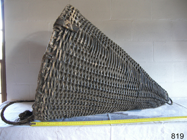
Equipment - Distant Signal, 1897-1931
This three-dimensional Distant Signal is part of a Flagstaff Signal set of ball, cone and drum shapes. It has been woven and then fabricated with strong metal swivel fittings and loops for suspending from a high point on a flagstaff at a signal station or on a ship’s masthead. The cane signal was constructed to withstand all weather and to be visible from a long distance. The gaps between the woven cane allow air to pass through, minimising possible swaying. Similar sets were made from rope or fabric. Warrnambool's Flagstaff was erected in 1854. Its primary use was to display visual signals that could convey messages between land and sea. It was also used to notify the local population of the approach of ships. One of the popular signalling codes in use in the early-to-mid 1800s was the Marryat’s Code but there were others in use as well; there was no one standard code. In 1857 the International Marine Conference adopted an International Code of Signals as a standard communications system for all vessels that could be understood in many different languages. The Normanby Advertiser reported on June 5th 1857 a query from the Post Master General as to whether the request of the Chief Harbour Master would be carried out, in that Warrnambool would receive a new flagstaff and a set of Marryatt’s signal flags. The Table of Codes was published, showing how to use combinations of these flags to send messages. The Code was revised in 1887 to cover situations where distance, light, wind and weather conditions affected the visibility of the flags and prevented clear communication. The first report of the International Code of Signals Committee of 1897 warned signalmen not to rely on ordinary semaphore flags and introduced a Distant Signal Code using either particular semaphore flags or the three-dimensional shapes of a ball, cone and drum that aligned with the semaphore flag shapes of a circle, pennant and square. International Code of Signals In 1931, after World War I’s experiences in using signal codes, the International Code of Signals conference in Washington revised and published the rules for the conduct of signalling. One of the changes was that “the use of the Distant Signals and of fixed semaphore was abandoned”. It is of interest to know that modern marine law in many countries insists that a set of Day Shapes must be carried onboard vessels of a certain size. These highly visible geometric shapes are used at sea in daylight to communicate messages between vessels. They are used in a similar way to the Distant Signals, in that different combinations of shapes represent different messages. The set of shapes includes a ball, cylinder, cone and diamond. The shapes are hung between the top of the vessel’s foremast and the front of the vessel. They are only coloured black and are about 1.5 metres high. The vertical line of shapes can mean messages such as Boat not under command, Fishing, and Under sail and power.Distant Signals were an important means of marine communication from the late 1880s to the early 1930s, including during World War I. They were an advancement to the International Shipping Codes and safety. The cane signals’ shapes appear to be the same from whatever direction they are viewed, removing confusion about the message they convey. The same shapes continue to be used today for the sets of Day Shapes used as marine navigational signals that are mandatory on certain-sized vessels.Distant Signal Cone, part of a Flagstaff signal set. A woven cane cone, painted black, with a metal rod passing through the centre and two crossed metal bars at the base. The central rod has a loop at the top and passes through the bars at the base, finishing in a metal loop. The rod has swivels at each end.flagstaff hill, warrnambool, flagstaff hill maritime museum and village, shipwreck coast, marine navigation, marine communications, communication signal, lifesaving, ship at sea, day shape, masthead signal, day signal, day mark signals, marine technology, safety equipment, navigation equipment, marine day shape, day marker, cane day shape, signal cone, day signal cone, cone signal, cone day shape, distant signal, flagstaff signal, signal station, communications, signals, marine signals, flaghoists, international marine conference, international code of signals, signal codes, marine safety, signal flags, daymark, day symbol, navigation, warrnambool flagstaff, 1854, 1857 1931, 1887, 1897 -
 Flagstaff Hill Maritime Museum and Village
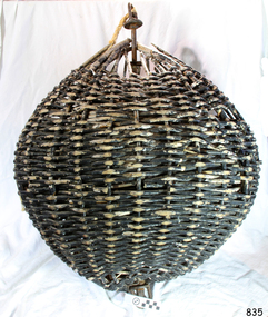
Equipment - Distant Signal, 1897-1931
This three-dimensional Distant Signal is part of a Flagstaff Signal set of ball, cone and drum shapes. It has been woven and then fabricated with strong metal swivel fittings and loops for suspending from a high point on a flagstaff at a signal station or on a ship’s masthead. The cane signal was constructed to withstand all weather and to be visible from a long distance. The gaps between the woven cane allow air to pass through, minimising possible swaying. Similar sets were made from rope or fabric. Warrnambool's Flagstaff was erected in 1854. Its primary use was to display visual signals that could convey messages between land and sea. It was also used to notify the local population of the approach of ships. One of the popular signalling codes in use in the early-to-mid 1800s was the Marryat’s Code but there were others in use as well; there was no one standard code. In 1857 the International Marine Conference adopted an International Code of Signals as a standard communications system for all vessels that could be understood in many different languages. The Normanby Advertiser reported on June 5th 1857 a query from the Post Master General as to whether the request of the Chief Harbour Master would be carried out, in that Warrnambool would receive a new flagstaff and a set of Marryatt’s signal flags. The Table of Codes was published, showing how to use combinations of these flags to send messages. The Code was revised in 1887 to cover situations where distance, light, wind and weather conditions affected the visibility of the flags and prevented clear communication. The first report of the International Code of Signals Committee of 1897 warned signalmen not to rely on ordinary semaphore flags and introduced a Distant Signal Code using either particular semaphore flags or the three-dimensional shapes of a ball, cone and drum that aligned with the semaphore flag shapes of a circle, pennant and square. International Code of Signals In 1931, after World War I’s experiences in using signal codes, the International Code of Signals conference in Washington revised and published the rules for the conduct of signalling. One of the changes was that “the use of the Distant Signals and of fixed semaphore was abandoned”. It is of interest to know that modern marine law in many countries insists that a set of Day Shapes must be carried onboard vessels of a certain size. These highly visible geometric shapes are used at sea in daylight to communicate messages between vessels. They are used in a similar way to the Distant Signals, in that different combinations of shapes represent different messages. The set of shapes includes a ball, cylinder, cone and diamond. The shapes are hung between the top of the vessel’s foremast and the front of the vessel. They are only coloured black and are about 1.5 metres high. The vertical line of shapes can mean messages such as Boat not under command, Fishing, and Under sail and power.Distant Signals were an important means of marine communication from the late 1880s to the early 1930s, including during World War I. They were an advancement to the International Shipping Codes and safety. The cane signals’ shapes appear to be the same from whatever direction they are viewed, removing confusion about the message they convey. The same shapes continue to be used today for the sets of Day Shapes used as marine navigational signals that are mandatory on certain-sized vessels.Distant Signal Ball, part of a Flagstaff signal set. A round woven cane ball, painted black, with a metal rod passing through the centre. The rod has a loop at each end, then a concave, octagonal metal plate that rests on the outside surface of the ball, serving as a washer. The rod has swivels at each end.flagstaff hill, warrnambool, flagstaff hill maritime museum and village, shipwreck coast, marine navigation, marine communications, communication signal, lifesaving, ship at sea, day shape, masthead signal, day signal, day mark signals, marine technology, safety equipment, navigation equipment, marine day shape, day marker, cane day shape, signal ball, day signal ball, ball signal, ball day shape, distant signal, flagstaff signal, signal station, communications, signals, marine signals, flaghoists, international marine conference, international code of signals, signal codes, marine safety, signal flags, daymark, day symbol, navigation, warrnambool flagstaff, 1854, 1857 1931, 1887, 1897 -
 Flagstaff Hill Maritime Museum and Village
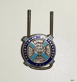
badge - Presbyterian Brotherhood badge, 1920s to 1940s
This badge is one of a set of badges collected by Dr W R Angus from the organisations in which he was involved. The set of badges is now part of Flagstaff Hill’s comprehensive W.R. Angus Collection, donated by the family of Dr W R Angus, surgeon and oculist. The badge represents the Australian Presbyterian Brotherhood. The Presbyterian church has used the burning bush logo from the 1800s. The logo describes the Biblical account of the prophet Moses, who saw the miracle of a bush on fire that did not burn and heard the voice of God giving his instructions. The light blue cross symbolises the origin of the Australian Presbyterian church, the Church of Scotland, which is Presbyterian. Its flag is blue with a white 'x' and a burning bush symbol in the centre. Dr William Roy Angus was of Scottish heritage. He sailed overseas to further his studies at Edinburgh Royal Infirmary and in 1928, was awarded FRCS (Fellow from the Royal College of Surgeons), Edinburgh, Scotland. He was e Presbyterian and treated Sunday as a Sabbath, a day of rest. He would visit three or four country patients on a Sunday, taking his children along ‘for the ride’ and visiting with him. Sunday evenings he would play the pianola and sing Scottish songs to his family. In 1928, Dr Angus was a Flying Doctor in the A.I.M. (Australian Inland Ministry) Aerial Medical Service, which was established by the Presbyterian Church in that year. The W.R. Angus Collection includes historical medical equipment, surgical instruments and material belonging to Dr Edward Ryan and Dr Thomas Francis Ryan, (both of Nhill, Victoria) and Dr Angus’ own belongings. The Collection’s history spans the medical practices of the two Doctors Ryan, from 1885-1926 plus that of Dr Angus, up until 1969. It includes historical medical and surgical equipment and instruments from the doctors Edward and Thomas Ryan of Nhill, Victoria. Dr Angus married Gladys in 1927 at Ballarat, the nearest big city to Nhill where he began as a Medical Assistant. He was also Acting House surgeon at the Nhill hospital where their two daughters were born. During World War II He served as a Military Doctor in the Australian Defence Forces. Dr Angus and his family moved to Warrnambool in 1939, where Dr Angus operated his own medical practice. He later added the part-time Port Medical Officer responsibility and was the last person appointed to that position. Both Dr Angus and his wife were very involved in the local community, including the planning stages of the new Flagstaff Hill and the layout of the gardens there. Dr Angus passed away in March 1970.This badge is significant for connecting Doctor Angus with organisations that he supported. The badge also associates Dr Angus with the history of the Presbyterian Church in Australia, showing the historic logo of the burning bush and the Scottish flag. The W.R. Angus Collection is significant for still being located at the site it is connected with, Doctor Angus being the last Port Medical Officer in Warrnambool. The Collection includes historical medical objects that date back to the late 1800s.Badge; a round badge with a blue enamel outer border in front of a light blue enamel ‘x’. A silver logo is on top of the 'X'. There is a silver inscription around the outer circle. It is the badge of the Presbyterian Brotherhood of Australia.This badge is part of a set of badges collected by Dr W R Angus. the set represents organisations that he was involved in, and is part of the W.R. Angus Collection.On the dark blue border: “PRESBYTERIAN BROTHERHOOD’ Logo [a bush on fire] a 'burning bush'flagstaff hill, warrnambool, maritime village, maritime museum, shipwreck coast, great ocean road, w.r. angus, badge, organisation badge, flagstaff hill maritime museum and village, badges, buttons, lapel badge, religious badge, denominational badge, presbyterian church, presbyterian brotherhood, hat pin, flying doctor, scottish heritage, w.r. angus collection -
 Flagstaff Hill Maritime Museum and Village
Equipment - Distant Signal, 1897-1931
This three-dimensional Distant Signal is part of a Flagstaff Signal set of ball, cone and drum shapes. It has been woven and then fabricated with strong metal swivel fittings and loops for suspending from a high point on a flagstaff at a signal station or on a ship’s masthead. The cane signal was constructed to withstand all weather and to be visible from a long distance. The gaps between the woven cane allow air to pass through, minimising possible swaying. Similar sets were made from rope or fabric. Warrnambool's Flagstaff was erected in 1854. Its primary use was to display visual signals that could convey messages between land and sea. It was also used to notify the local population of the approach of ships. One of the popular signalling codes in use in the early-to-mid 1800s was the Marryat’s Code but there were others in use as well; there was no one standard code. In 1857 the International Marine Conference adopted an International Code of Signals as a standard communications system for all vessels that could be understood in many different languages. The Normanby Advertiser reported on June 5th 1857 a query from the Post Master General as to whether the request of the Chief Harbour Master would be carried out, in that Warrnambool would receive a new flagstaff and a set of Marryatt’s signal flags. The Table of Codes was published, showing how to use combinations of these flags to send messages. The Code was revised in 1887 to cover situations where distance, light, wind and weather conditions affected the visibility of the flags and prevented clear communication. The first report of the International Code of Signals Committee of 1897 warned signalmen not to rely on ordinary semaphore flags and introduced a Distant Signal Code using either particular semaphore flags or the three-dimensional shapes of a ball, cone and drum that aligned with the semaphore flag shapes of a circle, pennant and square. International Code of Signals In 1931, after World War I’s experiences in using signal codes, the International Code of Signals conference in Washington revised and published the rules for the conduct of signalling. One of the changes was that “the use of the Distant Signals and of fixed semaphore was abandoned”. It is of interest to know that modern marine law in many countries insists that a set of Day Shapes must be carried onboard vessels of a certain size. These highly visible geometric shapes are used at sea in daylight to communicate messages between vessels. They are used in a similar way to the Distant Signals, in that different combinations of shapes represent different messages. The set of shapes includes a ball, cylinder, cone and diamond. The shapes are hung between the top of the vessel’s foremast and the front of the vessel. They are only coloured black and are about 1.5 metres high. The vertical line of shapes can mean messages such as Boat not under command, Fishing, and Under sail and power.Distant Signals were an important means of marine communication from the late 1880s to the early 1930s, including during World War I. They were an advancement to the International Shipping Codes and safety. The cane signals’ shapes appear to be the same from whatever direction they are viewed, removing confusion about the message they convey. The same shapes continue to be used today for the sets of Day Shapes used as marine navigational signals that are mandatory on certain-sized vessels.Distant Signal Cone, part of a Flagstaff signal set. A woven cane cone, painted black, with a metal rod passing through the centre and two crossed metal bars at the base. The central rod has a loop at the top and passes through the bars at the base, finishing in a metal loop. The rod has swivels at each end.flagstaff hill, warrnambool, flagstaff hill maritime museum and village, shipwreck coast, marine navigation, marine communications, communication signal, lifesaving, ship at sea, day shape, masthead signal, day signal, day mark signals, marine technology, safety equipment, navigation equipment, marine day shape, day marker, cane day shape, signal cone, day signal cone, cone signal, cone day shape, distant signal, flagstaff signal, signal station, communications, signals, marine signals, flaghoists, international marine conference, international code of signals, signal codes, marine safety, signal flags, daymark, day symbol, navigation, warrnambool flagstaff, 1854, 1857 1931, 1887, 1897 -
 Glen Eira Historical Society
Article - Glenhuntly Athletic Club
Correspondence received from Victorian Athletic Association with regard to assistance given by the city of Caulfield for Victorian road running championships at Caulfield Racecourse 1987, dated 16/06/1987 An article from the Caulfield /Port Phillip Leader on Sean Wroe’s participation in the Melbourne track classic, dated 01/03/2011 An article from the Caulfield /Port Phillip Leader on the success of Glen Huntly Athletic Club at the Victorian Youth Championship , dated 08/03/2011 An article from the Caulfield /Port Phillip Leader on Glen Huntly Athletic Club’s ‘participation in the Australian 20km walk championship and the Australian Athletics tour, dated 08/03/2011 An article from the Caulfield / Port Phillip Leader on Glen Huntly Athletic Club's’ win of the HH Hunter Shield, dated ,15.03.2011 An article from the Caulfield / Port Phillip Leader on Glen Huntly Athletic Club’s wins at the Australian Junior Athletics Championship, dated 22.03.2011 An article from the Caulfield/ Port Phillip Leader on Sean Wroe from the Glen Huntly Athletic’s Club participation in the Australian Athletic’s Championship and World championship, dated 12.04.2011 An article from the Caulfield/ Port Phillip Leader on Glen Huntly Athletic’s Club’s participation in the Victorian cross country r5elay Championship, dated 17.05.2011 An article from the Caulfield /Port Phillip Leader on Sean Wroe and Kelly Hetherington representing Glen Huntly Athletic Club at the World University games in China, dated 09.08.2011 An article from the Caulfield/ Port Phillip Leader on the success of the Women from Glen Huntly Athletic Club at the Athletics Victoria road relay Championship, dated 16.08.2011 An article from the Caulfield/ Port Phillip Leader on the Sean Wroe, from the Glen Huntly Athletic Club ,bronze medal win at the World university Games in China, dated 30.08.2011 An article from the Caulfield/Port Phillip Leader on Glen Huntly Athletic Club’s participation in the Athletics Victoria summer shield series dated 25. 10.2011 An article from the Caulfield /Port Phillip Leader on the success of Glen Huntly Athletic Club at round 2 of the Summer Shield series , dated 1.11.2011 An article from the Caulfield/ Port Phillip Leader on the placing of the Glen Huntly Athletic Club at round 3 of the Summer Shield series , dated 8.11.2011 An article from the Caulfield/ Port Phillip Leader on the success of the Glen Huntly Athletic Club at round 3 of the summer shield series ,dated 22.11.2011victorian athletic association, city of caulfield, caulfield, caulfield south, glen huntly athletic club, campbell jack cr, caulfield racecourse, aylen d.r, melvin david, onley peter, etherington chris, victorian olympic council inc, sports federation of victoria inc, australian athletic union, victorian road running championship, mason gregor, clubs, associations, sports, recreations, competitions, sporting clubs, leisure, cultural events, cultural associations, running, athletics, victorian open, awd track and field championship, hh hunter shield, wroe sean, sports grounds, ovals, parks, reserves, melbourne track classic, victorian track and field championship, australian athletics, australian junior athletics championship little athletics, state track and field championship, australian athletics championship, world championship, victorian cross country relay championship, the hunters, the lady hunters, sports people, the world university games, athletics victoria, road relay championship australian commonwealth games association athletics victoria, victorian youth championship, summer shield series, entertainment, carter matt, krawitz shaun, nelson jordan, dillon hunter jonathan, cowley rhydian, satupai margaret, mulhall kim, clarken lielani, lappin. jake gallagher jessica, kauffman jessica, hoilten ruby, edwards julia, thompson noni, rarasinghe kulan, fountain erica, seibold- crosbie kate, offereins ben, moore kevin, milburn joel, steffensen john, rouge-serret aaron, hetherington kelly, kingdom trychelle, ryde michael, flook, isabella, debonolt kayla, nakase taishi, lund sarah, cuttler claire, santa jason, alves francesca, lagreca marcus, nomikoudis maria, brammer ally, kolokythas keelan, clarksen oisin, hibbert chris, green ellia, palackic ian, nakase kaori, edwards nicholas, globan like, mc lean emily, anthony nicola, robertson adelaide, lang chynea, mac lean tom, hart darren, kanneh vandy, wiseman angus, thompson riley, montag jemima, watson sasha, mouratch daniel, montag piper, brammer bridget, mc donald geogie, mckenzie charlotte, kelaart oliver davis nicola, katsanevakis katherine, fyfe karinna, dick kylie, thompson anna, dennett belinda, corcoran bridget, beech georgina, fletcher robyn, grimes lesley, nakase paulg, suteau frederic, bowly simon, bott justin, radose vic nenad, lelehan shaun, weatherall bridget, cook meredith, higham cassie, bennett belinda, macknamara peter, harvey mattew, miller brendan, golonka kurt, robertson hamish, byrne angela, soderstrom roland, mcinnes simone, lang beau, hodgens ben, shephert jarrod, crane jordon, beadman mackenzie, russo antonio, doran anthony, hanrahan justin, cohen justin, allen linda, austin juliet, lang beau, little william, arthur mikhalla, roberts amy rose, beraun patrick, carothers callum, byrne shane, papanikolaou joshua, cater adam, rainey helen, hutton philip, zeleznikow john, glico tim, hamilton lucy, ross anna, ione casey, phelan leigh, russo anthony, hogben lachlan, vandwater melissa, gray molly, cleary sarah, parrish katy, comport michael, parkinson nick, byrne christine, wood courtenay, macknamara kellie, axford tyse, zele znioko eva, beguely patricktelfer olivia, nomikoudis john, kelaart isabel, miller aaron, oglesby david, llewelyn hannah, hamilton daniel, holmstorm maddison, winter chris, lang jeffrey, caulfield/port phillip leader -
 Flagstaff Hill Maritime Museum and Village
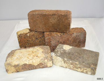
Ceramic - Clay Bricks, Circa 1838
These bricks are a sample of “5000 house bricks from London” carried by the CHILDREN as ballast, and intended for the Portland Bay settlement of her owners Henty Bros. Flagstaff Hill divers recovered them from Childers Cove in February 1974, and noted, “These bricks are the major feature of the wreck site. Subsequent notes indicate “The hull structure has broken up, leaving few visible remains, except for piles of house bricks intended for the Hentys of Portland”. According to Lloyds Shipping Register 1837-1839, the CHILDREN was built in 1825 at Liverpool and operated by owners Gordon & Co, of London, London registered number 123/1837; James Henty then bought her in 1837 as a three-masted barque of 254 tons, with a hull of “part pitch pine, felt sheathed” and “coppered 1837”. Launceston registered number 6/1837; in 1838 the CHILDREN, under her master Captain H. Browne, completed a successful round trip from Launceston to London (carrying wool and whale oil loaded in Portland), returning in late November of that year (carrying general cargo including the house bricks). On the 11th of January 1839, the CHILDREN sailed from Launceston for Adelaide, with 24 passengers, 14 crew, and an awkward mixed cargo, including 1500 sheep, 8 bullocks, 7 horses, and farming implements, and six whaleboats with associated whaling gear. One account states that when the CHILDREN “put out from port she was light and badly ballasted”. The vessel immediately encountered four days of hurricane-force storms, eventually clearing on the early morning of the 14th to “west force 10”, but too late to take accurate measurements of the sun or stars to establish their position relative to the coast. The CHILDREN collided with a limestone stack at the entrance of Childers Cove, and the seas smashed her into pieces within half an hour. All the cargo and 16 lives were lost (including 8 children). The Hentys contributed £150 towards a fund for the 22 survivors at a memorial service held in Launceston later that year. It was a major financial setback for the Hentys, but one from which they recovered. In a submission to the Governor of New South Wales dated 24 March 1840, the Hentys summarised their work over the previous six years of settlement: “Six stations have been occupied, one at Portland Bay…three at the open country about 60 miles inland called ‘Merino Downs’…They have erected two houses at Portland Bay and two others at Merino Downs”.These bricks are significant as a sample of 5000 house bricks carried from London as ballast by the Children and were intended for the Portland Bay settlement of her owners James Henty & Co. The CHILDREN was one of the first vessels to be lost in the Western District of Victoria, east of Warrnambool, on January 14th 1838, breaking up within twenty minutes. The wreck is also significant as one of the first vessels to have been lost in the Western District of Warrnambool and as such is registered on the Victorian Heritage Register S116.Five ‘house bricks from London’, some with white marine encrustation, recovered from the wreck of the ship CHILDREN. The bricks are oblong shaped and constructed of a blue-coloured and coarse-grained conglomerate. One brick is higher, shorter and narrower, than the other four bricks.Nonewarrnambool, shipwreck coast, flagstaff hill, shipwrecked coast, flagstaff hill maritime village, flagstaff hill maritime museum, shipwreck artefact, maritime museum, london house bricks, children shipwreck, james henty and co, henty brothers, childers cove, early shipowreck -
 Flagstaff Hill Maritime Museum and Village
Equipment - Distant Signal, 1897-1931
This three-dimensional Distant Signal is part of a Flagstaff Signal set of ball, cone and drum shapes. It has been woven and then fabricated with strong metal swivel fittings and loops for suspending from a high point on a flagstaff at a signal station or on a ship’s masthead. The cane signal was constructed to withstand all weather and to be visible from a long distance. The gaps between the woven cane allow air to pass through, minimising possible swaying. Similar sets were made from rope or fabric. Warrnambool's Flagstaff was erected in 1854. Its primary use was to display visual signals that could convey messages between land and sea. It was also used to notify the local population of the approach of ships. One of the popular signalling codes in use in the early-to-mid 1800s was the Marryat’s Code but there were others in use as well; there was no one standard code. In 1857 the International Marine Conference adopted an International Code of Signals as a standard communications system for all vessels that could be understood in many different languages. The Normanby Advertiser reported on June 5th 1857 a query from the Post Master General as to whether the request of the Chief Harbour Master would be carried out, in that Warrnambool would receive a new flagstaff and a set of Marryatt’s signal flags. The Table of Codes was published, showing how to use combinations of these flags to send messages. The Code was revised in 1887 to cover situations where distance, light, wind and weather conditions affected the visibility of the flags and prevented clear communication. The first report of the International Code of Signals Committee of 1897 warned signalmen not to rely on ordinary semaphore flags and introduced a Distant Signal Code using either particular semaphore flags or the three-dimensional shapes of a ball, cone and drum that aligned with the semaphore flag shapes of a circle, pennant and square. International Code of Signals In 1931, after World War I’s experiences in using signal codes, the International Code of Signals conference in Washington revised and published the rules for the conduct of signalling. One of the changes was that “the use of the Distant Signals and of fixed semaphore was abandoned”. It is of interest to know that modern marine law in many countries insists that a set of Day Shapes must be carried onboard vessels of a certain size. These highly visible geometric shapes are used at sea in daylight to communicate messages between vessels. They are used in a similar way to the Distant Signals, in that different combinations of shapes represent different messages. The set of shapes includes a ball, cylinder, cone and diamond. The shapes are hung between the top of the vessel’s foremast and the front of the vessel. They are only coloured black and are about 1.5 metres high. The vertical line of shapes can mean messages such as Boat not under command, Fishing, and Under sail and power.Distant Signals were an important means of marine communication from the late 1880s to the early 1930s, including during World War I. They were an advancement to the International Shipping Codes and safety. The cane signals’ shapes appear to be the same from whatever direction they are viewed, removing confusion about the message they convey. The same shapes continue to be used today for the sets of Day Shapes used as marine navigational signals that are mandatory on certain-sized vessels.Distant Signal Ball, part of a Flagstaff signal set. A round woven cane ball, painted black, with a metal rod passing through the centre. The rod has a loop at each end, then a concave, octagonal metal plate that rests on the outside surface of the ball, serving as a washer. The rod has swivels at each end.distant signal, flagstaff signal, signal station, masthead signal, communications, marine technology, signals, marine signals, flaghoists, international marine conference, international code of signals, signal codes, marine safety, signal flags, day shape, daymark, day symbol, navigation, warrnambool flagstaff, 1854, 1857 1931, 1887, 1897 -
 City of Moorabbin Historical Society (Operating the Box Cottage Museum)
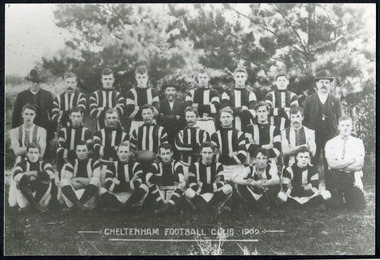
Photographs, x 3 Black & White Cheltenham Football Club 1909,1913, 1946, 20thC
Known as the Rosellas, the early Cheltenham Football Club sides began playing on a regular basis in 1890, and would travel long distances by steam train to play country teams, such as Ballarat where they would arrive at their destination, play the match, socialize then return to the station. Opposition players and supporters would give three hearty cheers on their departure. The Cheltenham home games were played on a paddock on the corner of Park and Charman roads in Cheltenham. In 1907 the Cheltenham progress committee made an application to the board of land works for land in Weatherall Road for recreational service to the public. That application was received and granted, then developed where Cheltenham Recreational Reserve now stands. The land in the early days was virgin bush and the response for voluntary help to clear the area was outstanding. Nearly all the market gardeners in the district along with horses, ploughs, axes, shovels completely cleared the area in three weeks. The Moorabbin council then leveled the playing area and erected a post and rail fence around the ground. Pine tree shrubs were then planted on the west side of the ground. The ground was opened in 1909 and the first Cheltenham side entered in the newly formed Federal Football Association along with seven other foundation members, Mordialloc, Mentone, Moorabbin, Frankston, Glenhuntly, Elsternwick, and Ellindale. The grand final for that year, 1909 was a hard encounter between Cheltenham and Ellindale with Cheltenham coming out victors, thus becoming the inaugural Federal Football Association premiers. Cheltenham went onto win five senior premierships in the Federal Football Association by the end of the 1920s, they won the flags in 1909, 1911, 1913, 1922 and 1925, with the late Percy Woff playing in all 5 premiership sides and was captain in 1922. 1928 saw the start of an outstanding career from our oldest living player Tom Connor. Cheltenham continued to win premierships in the 1920’s and 1930’s with juniors taking out the 1929 and 1933 flags, under the guidance of Woff, and that continued in 1934 when Cheltenham took out the 1st XVIII and 2nd XVIII premierships. Cheltenham produced its only Brownlow medallist in Peter Box who played in the late 1940s, before going to Footscray where he became a champion. The 3rd XVIII went through the season undefeated in 1974 winning the premiership, with Trevor Barker a key player before going to St Kilda the following year. The club won three senior premierships under coach Barry White in 1992, 1993 and 1995. ( from CFNC website 2019) Cheltenham Football Club was formed 1890 and succeeded in winning many Premierships as a member of the Federal Football Association, Outstanding players Peter Box Brownlow Medalist 1956 Footscay VFL, , Trevor Barker and Kevin Roberts St Kilda VFL.3x Black & White photographs of the players in the Australian Rules Cheltenham Football Club 1909, 1913 and 1946 extra photo of Peter Box Folio 10 MAV 01059a) CHELTENHAM FOOTBALL CLUB 1909 Cheltenham Football Club 1909. Back row: A Chandler, committee member; R. Robertson, back-pocket; J. Harris, half back flank; J Adams, ruck and forward-pocked; M. J. Monk, club president; L. Woff, back-pocket; W. Adams, ruck and back-pocket; P. Woff, rover and forward-pocket; A Monk, committee member. Middle row: W. Hore, back pocket and ruck; A. Towns, half-forward flank; W. Carson, full back; F. Andrews, captain-half forward flank; H. Butler, centre half back; J. Warburton, centre half-forward; A. Slater, half-back flank; F. Fisher, half-forward flank; C. Sherwood, trainer. Front Row: G Gouldthorpe, wing; H. King, full-forward; W. Johnston, ruck and forward-pocket; P Spears, rover and forward-pocket; F. Bichl, wing; A. Bichl. rover and forward-pocket; F. Butler, centre player. Courtesy, Lionel Seal. ( from CFC website 2019) b) CHELTENHAM 1913 PREMIERS c) CHELTENHAM -1946 / Back row - J. Fisher, G.Corrigan, N.Hocking, F.Virtue, R.Craven, L.Baker, M.Blundell / 2nd Row - J.Phillips, T.Connor, E.Hawkins, A.Blakely, G.Baker, A.Dark, J.Barker, D.Craven, J.Pickering, P.Cameron,/ W.Hicks, G.Hoskings, R.Beihl, A.Hubbard, R.Kier, C.Russell. / Front Row - Clark Taylor, J.Slade, N.Niel, J.Brooks, T,Butler, H.Hosking, C.Hacusler, E.Hornibrook, W.Briggs, B.Russell, L.Biehl, / W Ripponcheltenham football club, australian rules football, victorian football association, victorian football league, smith j l; smith mary ann, stanley helen, , chaff cutter, horse drawn carts, toll gates brighton, motor cars 1900, steam engines, early settlers, bentleigh, parish of moorabbin, city of moorabbin, county of bourke, moorabbin roads board, shire of moorabbin, henry dendy's special survey 1841, were j.b.; bent thomas, o'shannassy john, king richard, charman stephen, highett william, ormond francis, maynard dennis, market gardeners, vineyards, orchards, cheltenham, two acre village, holloway josiah,, woff percy, connor tom, box peter, barker trevor, white barry, browlow charles, -
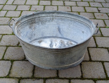 Sunshine and District Historical Society Incorporated
Galvanised Wash Tub, Probably Circa 1940's
Many displaced people who migrated to Australia after World War 2 brought similar tubs with them as part of their luggage. The tubs were valued by the migrants because they were used for washing clothes and other laundry items, and for bathing children and even adults. The tub in our possession was brought out to Australia in 1950 by the Pierzak family who eventually settled in North Sunshine, Victoria. The following story about the Pierzak family has been provided by the daughter Halina Wlodarczyk (nee Pierzak). The father Stanislaw Pierzak was born on the 26th of July 1916 in Zbrza, and the mother Teodozja (Teodozia) Szalas on the 5th of March 1919 in Goleciny, both villages in the Kielce district of Poland. In 1940 they were both taken by the German Army to work as slave labour on farms in Germany. Stanislaw worked in the Saxonia area and Teodozja near Dillingen. The work was hard, and when Teodozja contracted pneumonia she was told that she would not be given any food if she did not work. After the war the displaced persons, as they were called, were settled in various barracks and camps organised by the United States Army. Stanislaw and Teodozja married in Gablingen, Bavaria, Germany, and Halina was born in the camp at Gablingen in 1949. The displaced people were given the choice of several countries if they wanted to migrate from war torn Germany, and so the Pierzak family chose Australia. The Pierzak family set sail from Naples, Italy aboard the ship General M. B. Stewart and arrived in Sydney on the 17th of April 1950. The men and women had to stay in separate quarters, and many passengers were so sick that they did not think they would survive the journey. In Australia they lived in migrant camps in NSW at Bathurst, Orange, Parkes and Cowra. To pay off their fares to Australia migrants were required to work under contract for 2 years. Stanislaw Pierzak worked in Broken Hill NSW returning to visit his family every 3 to 4 months. The son John was born in the Red Cross building at the Parkes camp in 1952. In 1953 the whole family moved to Melbourne and lived in a converted garage in Victor Street, North Sunshine. In 1954 the family bought a bungalow on a block of land in Compton Parade, North Sunshine, where eventually they built a house. Stanislaw Pierzak worked at Steelweld in Ashley Street, Braybrook travelling there on his bicycle, while Teodozja Pierzak found work at Smorgon in West Footscray. Stanislaw and Teodozja Pierzak lived in North Sunshine for the rest of their lives, and Mrs Pierzak always said that Sunshine was the best place in the world.Tubs like this which belonged to displaced people were highly valued possessions and are of historic significance. They were brought out to Australia after World War 2 by many migrating displaced families. The tubs were used for washing activities in the camps in Germany, and the migrant camps in Australia, and also when people lived in bungalows in Australia before they built houses with laundries and bathrooms.Oval shaped galvanised iron tub with two rigid handles, one at each end. The top of the tub is larger than the base. The galvanising is deteriorating in some parts which show a whitish appearance. There are some small dents, and a few chips in the galvanising where surface rust has appeared.The number 70 is stamped on both sides.washing tub, galvanised tub, laundry, bath, displaced persons, immigration, general m. b. stewart, galvanized tub, pierzak, galvanised wash tub -
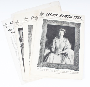 Melbourne Legacy
Journal - Document, set of newsletters, Legacy Newsletter, August 1942 to September 1959
A newsletter published by Legacy in this format for many years from 1942. They mentioned "Issued from time to time for Private Circulation among the Sons and Daughters of Deceased Service men and Merchant Seamen who served their Country during the War of 1914-18, or the present War" Many articles on the work of Legacy, including features on boys classes, girls classes, camps, the residences and where their past residents ended up. There are some suggestion for careers and some general interest articles. Some very interesting photos. Issues: Vol. 1 No. 1 (August, 1942) Vol. No 2 (October 1942) Vol. 1 No 3 (December 1942) Vol. 1 No 4 (July 1943) Vol 1. No 6 (December 1944) Vol. 1 No 7 (March, 1945) Vol. 1 No 8 (June, 1945) Vol. 1 No 9 (November 1945) Vol. 1 No 12 (August 1946) Vol. 2 No 1 (October, 1946) Vol. 2 No 2 (December, 1946) Vol. 2 No 4 (May 1947) Vol. 2 No 5 (September, 1947) Vol. 2 No 6 (December, 1947) - 2 copies Vol. 2 No 7 (May 1948) Vol. 2 No 8 (August, 1948) Vol. 2 No 9 (November 1948) Vol. 3 No 10 (June 1949) - 2 copies Vol. 3 No 11 (September 1949) Vol. 4 No 1 (March 1950) Vol. 4 No 2 (October 1950) Vol. 4 No 1 (July 1951) - seems 'Vol 4' was used twice. Vol. 4 No 3 (December 1951) Vol. 5 No 2 (July 1952) Vol. 5 No 3 (December 1952) Vol. 6 No 1 (April 1953) Vol. 6 No 2 (September 1953) Vol. 7 No 1 (July 1954) Vol. 8 No 1 (June, 1955) - 2 copies Vol. 8 No 2 (October 1955) Vol. 9 No 1 (February 1956) Vol. 9 No 2 (August 1956) Vol. 9 No 3 (December, 1956) - 2 copies Vol. 10 No 1 (June, 1957) - 2 copies Vol. 10 No 2 (December, 1957) Vol. 11 No 1 (August, 1958) Vol. 11 No 2 (December, 1958) - 2 copies Vol. 12 No 1 (May 1959) - 2 copies Vol. 12 No 2 (August, 1959) Vol. 12 No 3 (September, 1959) Vol. 12 No 4 (December 1959)A record of newsletter published that reported on news of Junior Legatee activities.Newspaper style newsletter for Junior Legacy Club, Melbourne. 00019.1) Vol 1 No 1 August 1942 00019.2) Vol 1 No 2. October 1942 00019.3) Vol 1 No 3. December 1942 00019.4) Vol 1 No 4. July 1943 00019.5) Vol 1 No 6. December 1944 00019.6) Vol 1 No 7. March 1945 00019.7) Vol 1 No 8. June 1945 00019.8) Vol 1 No 9. November 1945 00019.9) Vol 1 No 12. August 1946 00019.10) Vol 2 No 1 October 1946 00019.11) Vol 2 No 2 December 1946 00019.12) Vol 2 No 4 May 1947 00019.13) Vol 2 No 5 September 1947 00019.14) Vol 2 No 6 December, 1947 00019.15) Vol 2 No 7 May, 1948 00019.16) Vol 2 No 8 August 1948 00019.17) Vol 2 No 9 November 1948 00019.18) Vol 3 No 10 June, 1949 00019.19) Vol 3 No 11 September, 1949 00019.20) Vol 4 No 1 March, 1950. Playing children on the cover. 12 pages 00019.21) Vol 4 No 2 October 1950. Girl and boy on cover. 12 pages 00019.22) Vol 4 No 1 July 1951 (note Vol and Number is same as 00019.20 but different edition). Sir Thomas Blamey on cover. 8 pages. 00019.23) Vol 4 No 3 Dec 1951. 00019.24) Vol 5 No 2 July 1952. 00019.25) Vol 5 No 3 December 1952. Sir Dallas Brooks on cover. 8 pages 00019.26) Vol 6 No 1 April 1953 00019.27) Vol 6 No 2 September 1953. Mother and son on cover. 16 pages 00019.28) Vol 7 No 1 July 1954 00019.29) Vol 8 No 1 June 1955. Portrait of Queen Elizabeth on the cover. 16 pages 00019.30) Vol 8 No 2 October 1955. Serviceman and toddler on the cover. 16 pages 00019.39) Vol 9 No 1 February 1956. Earl Mountbatten on the cover. 12 pages 00019.31) Vol 9 No 2 August 1956. Mayor Sir Frank Selleck on the cover. 16 pages 00019.40) Vol 9 No 3 December 1956 00019.32) Vol 10 No 1 June 1957 00019.32) Vol 10 No 2 December 1957 00019.33) Vol 11 No 1 August 1958 00019.34) Vol 11 No 2 December 1958 00019.35) Vol 12 No 1 May 1959 00019.36) Vol 12 No 2 August 1959 00019.37) Vol 12 No 3 September 1959 00019.38) Vol 12 No 4 December 1959newsletter, activities -
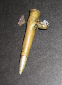 Kyneton RSL Sub Branch
WWI CARTRIDGE, WWI 1914-18
Pte Evan Edward Jones (No 276) and his younger brother Pte Edward Jones (No 1731) were both members of the 29 Infantry Battalion during World War 1. They enlisted in 1915 in Kyneton where they grew up. Edward enlisted after approval was given by his mother as he was not quite 21. He did not survive the war as he was killed by a sniper in France in 1916. It was Private Edward Jones’ love of adventure that cost him his life. In the trenches in France on 16 August 1916, beside his brother, Private Evan Edward, he raised his head and was caught by a German sniper. The brothers were side by side, and it was suggested to their sergeant that he should take a short rest; they had been 36 hours without sleep. The sergeant said “Oh no, I won’t leave you fellows.” Private Jones said “If I got a chance of a shut eye I’d take it.” He raised his head over the parapet and a German sniper caught him in the forehead, and shut his eyes forever. With difficulty his brother was restrained from rushing over the top for revenge. Evan survived the war, serving in France and Belgium. Some of his letters, together with other memorabilia, have been donated to the RSL by family members. One letter to his wife describes how a bullet hit a cartridge in his pouch but missed his body. Cartridges, the bullet and the piece of shrapnel are also included with the donated items. Part of one of Evan’s letters to his wife is re-printed here. “This bullet is the nearest thing as ever … since I have been in France. I wondered what struck me when it hit me, or rather hit the cartridge that was in my pouch. If it had been an inch or two higher it would have come through my body…the wish bone is from the fowl we had for supper last night, one of the boys bowled the fowl over with a stone so we got to work and cleaned and cooked it and it was just the thing. I got the wishbone so I thought it would be a good souvenir to send home…don’t forget to wish something nice with the wishbone.” Both boys had a strong sense of adventure and it was only natural that they fought and died for King and country. Original letters, photographs and documents have been copied for preservation. *Items donated by John and Phyllis Adams will form part of the World War One commemorative display at the Sub-Branch for Anzac Day 2015. The Jones boys grew up in the Kyneton area and enlisted in the AIF in Kyneton in 1915World War I cartridge damaged by another bullet. K15 VII on base of cartridge casingww1, pte evan jones, pte edward jones,, letters from the front -
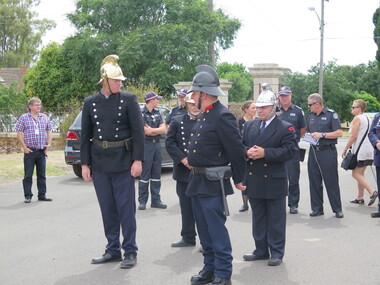 Bendigo Historical Society Inc.
Photograph - The Galatea Tragedy - 150th Anniversary, 18th Dec 2017
Born in 1844 Prince Alfred was the fourth child and second son of Queen Victoria and Prince Albert. He joined the Royal Navy at age 14 as a midshipman and by 1866 had attained the rank of captain and had command of HMS Galatea, a steam-powered sail-equipped frigate. In the same year, Alfred was made Duke of Edinburgh. In January 1867 the Galatea set sail from Plymouth on a round the world voyage visiting the Mediterranean before making a state visit to the emperor of Brazil. Two months were spent in the Cape Colony in South Africa before crossing the Indian Ocean to Australia. The Prince continued his tour to country Victoria and in Bendigo tragedy struck on 18th Dec 1867. A model of the royal ship Galatea, crewed by young boys, was the centerpiece of a reception and a procession. The procession circled round, and entering the Camp Reserve piled the torches into one general bonfire. At this time the demonstration of the evening was marred by a sad accident. The Bendigo Volunteer Fire Brigade put on a demonstration with lighted torches which were carelessly extinguished, embers floated onto the model ship which quickly caught fire. Witnesses also reported that firecrackers were being thrown. the accident was caused either owing, to the fireworks or careless use of the torches. Three boys in the model ship were burned to death and several others injured. The Volunteer Fire Brigades' rigged ship Galatea, which had formed a conspicuous object in the proceedings of the morning was driven along the crowded thoroughfare manned with young citizens dressed in sailor costumes, and took fire from the fireworks. Some of the sails immediately caught fire, and before an escape could be made, four of the occupants were most severely burnt. With. the assistance of the bystanders, the flames were quenched, but so severe were the injuries sustained by the lads, that they had to be conveyed to the hospital. Of the four, one, James Brown, son of Mr.James Brown, formerly, of the Water Supply department in Sandhurst and now of Tasmania, recovered from his injuries, but the other three died shortly after the accident. They were Wm. Langston McGrath, Sylvester Francis Cahill and Thomas Walters, each about eight years of age. They were buried at the Back Creek Cemetery, and a movement, initiated b ythe citizens, resulted in their graves being marked by public memorials. In connection with this sad event it should be mentioned that when the explosion of fireworks on board the model ship took place, Mr. Meagher, the captain of the brigade, although struck on the head by a rocket, dragged several of the boys from the flames. He and Mr. Hickey, one of the members of the brigade, were severely burned in their efforts to save the boys, in which they were assisted by Mr. Irving.Bendigo Historical Society excursion to the Bendigo Cemetery and visit to the graves and memorial of the three boys burned to death in a model of the ship Galatea during the visit of the Duke of Edinburgh in 1867. The DVD contains a slide show of the excursion. The photos taken by Libby Luke are published here.history, bendigo, galatea tragedy -
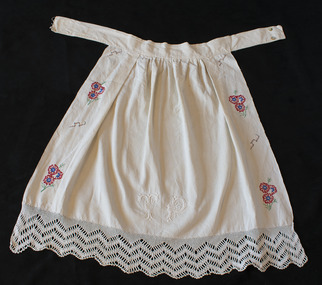 Brighton Historical Society
Apron, circa late 1800s, 1908 and 1950
Three generations of women are represented in this apron. The linen used was woven by Olga's great-grandmother Efstathia in the late nineteenth century with flax grown on the island of Ithaca. Olga's mother Toula Raftopoulos added the whitework around 1908 at age 16 - the first piece of lacework she made on her own - and embroidered her initials on the front. Olga embellished the apron with coloured embroidery around 1950 at age 20. Olga Maria Black was born in Melbourne in 1930, the daughter of Ithacan migrants Constantine and Toula Mavrokefalos. Constantine first emigrated to Australia in 1902, returning to Greece circa 1912-13 to serve his home country in the Balkan Wars. Toula's family had left Ithaca for Romania when she was only six months old, but she happened to be visiting the island at the very time that Constantine arrived, fresh from the war. Within three weeks they were married, and when Constantine returned to Melbourne in 1914 his new bride came with him. Constantine had trained as an accountant, but his qualifications were not recognised in Australia. Changing his surname to the Anglicised "Black", he started off working in his older brother Dionysios's cafés before going into business on his own. In 1917 he opened the Paris Residential Café at 54-56 Swanston Street, which offered both dining and accommodation. The business saw some years of success, but did not survive the Great Depression. Constantine died in 1944. Olga's mother Toula learned to sew as a child, while growing up in the Romanian village of Brila. She developed her skills making lace and embroidering items for her trousseau. Some of the linen she embroidered had been woven from flax on Ithaca by her own grandmother, Efstathia. During the Depression, when money was scarce, Toula embroidered at home, doing work for a factory in Flinders Lane. Using a cotton reel, a threepence and a sixpence she created and embroidered designs on hundreds of blouses. Olga spent her preschool days sitting at the table where her mother worked. Toula would involve Olga by allowing her to help choose the colour combinations. Toula lived with Olga in Brighton until her death in 1976. Olga inherited her mother's sewing skills. She re-invented some of Toula’s trousseau nightdresses and skilfully altered other clothing, making dresses which she wore around Brighton for many years.Cream linen embroidered half apron. White lace along hem, along with white embroidered initials, "T.P." Coloured floral and abstract embroidery along sides in red, black, blue and green.olga black, toula raftopoulos, migration, embroidery -
 Federation University Art Collection
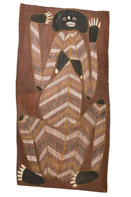
Painting - Natural pigment on bark, Mawurndjul, John, 'Female Wayarra Spirit' by John Mawurndjul, 1995
Balang [John MAWURNDJUL] (1952 - ) Born Mumeka, Northern Territory Country: Milmilngkan, West Arnham Land, Northern Territory Clan: Na-Kurulk Language Group: Kunwinjku Location: Milmilngkan John Mawurndjul is an Australian indigenous artist. He is a member of the Kuninjku people of West Arnhem Land, Northern Territory. Growing up John had only occasional contact with non-indigenous people and culture. He was tutored in rarrk, a traditional painting technique using fine cross hatching and infill, working on small barks. During the 1980s he started producing larger and more complex works. The artist has painted 'Wayarra', a generic term which can include both malevolent spirit beings which continually inhabit certain sites or objects but can also mean the Spirit of a recently deceased person. These spirits are one of two spirits of the dead, the other being the 'Kun-malng' soul. The 'Wayarra' is the shadow or 'shade' of the dead and may take on the form of the deceased and haunt areas where the deceased recently inhabited. In order to prevent Wayarra spirits from harassing relative of the recently deceased, a smoking ceremont is performed where Ironwood leaves are burnt around the camp of the recently deceased and ochre is rubbed on all objects belonging to the deceased. Ochre may also be rubbed on vehicles, houses and trees. Some Wayarra are a particular Dreaming totem for people of certain clans. This is why many artists depict Wayarra in their bark paintings and sculptures. They are depicting clan totems particular to their lineage and which are celebrated in major regional patrimoiety ceremonies. In 1989 the work of John Mawurndjul was included in the landmark exhibition "Magiciens de la Terra' at the Centre Pompidou and Grande Halle de la Vilette in Paris, France. His works have also been exhibited in numerous solo and group exhibitions in Australia, New York, Paris and Japan. Mawurndjul is one of eight artists whose work in part of the largest inernational commission of contemporary Indigenous art from Australia at the Musee du Quai Branly, Paris. The work was exhibited in the Australian survey "John Mawurndjul: I Am The Old And The New", at the Museum of Contemporary Art, one of the 160-odd works all chosen by Mawurndjul for inclusion in the exhibition. This item is part of the Federation University Art Collection. The Art Collection features over 1000 works and was listed as a 'Ballarat Treasure' in 2007.This artwork was chosen by John Murwurndjul as on of around 160 works for exhibition in the 2018 Australian Survey of his work at the Museum of Contemporary Art. The artist is known for his rarrk work, which is evident in 'Female Wayarra Spirit'.Aboriginal bark painting featurung rarrk. The artwork is associated with Dilebang, a duwa moiety place that belongs to the Kurulk clan. This work is currently on loan for exhibition in 'John Mawurndjul: I am the old and the new'. The exhibition will be shown at the Museum of Contemporary Art Australia (Sydney) from 6 July – 23 September 2018, and the Art Gallery of South Australia, Adelaide from 26 October 2018 – 28 January 2019.art, artwork, john mawurndjul, aboriginal, bark painting, rarrk, wayarra, kuninjku, maningrida, loan -
 Federation University Art Collection
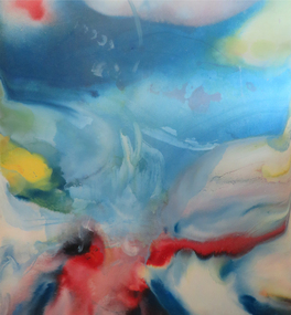
Painting, Norman Hofmaier, 'Promethius 1 from the Mallee Mysteries Series', by Norman Hofmaier
Norman Keith HOFMAIER (12.08.1951- ) Born Beulah, Wimmera, Victoria Norman Hofmaier was a scion of a well-known family, he completed his secondary education at Hopetoun High School and Ballarat College. Later he studied Visual Art at University of Ballarat, including painting, design and sculpture. Hofmaier’s childhood in Beulah was spent on the family property running beside the Yarriambiack Creek. Both he and his father had an intimate knowledge of the flora and fauna of the Mallee. The Wyperfeld National Park, home to the Big Desert, was a favourite place for Norman’s uncle who planted acres of native trees at the family property. Dr Di Bresciani explains: “The colours and vastness of the Mallee are represented in many works which reflect, variously, the relentless quiet and swirling energies found in the ‘dust storm might’ of the Mallee area. Most works may be described as abstract, lyrical abstract or abstract expressionist." From the 1970s until the 1990s he began an outpouring of work, using oil-based paints overlaid manually on large, specially-prepared boards using brushes, cloths, sponges, sprays or rollers. Petrol solvents were used to soften, blur and enhance shapes and edges. His work reflected his exploration of his inner state, sometimes flowing and placid, sometimes tempestuous. After a brief sojourn into city-life Norman returned to working in the country, until finally submitting to mental illness and permanent care in the mid 1990s. Norman Hofmaier's works are represented in major collections including that of the well- known artist Mitch Pearson ( an important influence and lifelong friend). The work 'Pastel of a Nude' was shown in a widely distributed magazine and two works owned by Mark Shannon were planned to be published as record covers in 1993. He won an award during the bicentennial recognising his skill as a Wimmera artist. From the 1970s until the 1990s he began an outpouring of work, using oil-based paints overlaid manually on large, specially-prepared boards using brushes, cloths, sponges, sprays or rollers. Petrol solvents were used to soften, blur and enhance shapes and edges. This work was purchased from the exhibition 'Norman Hofmaier: Mallee Mysteries' at the Lost Ones Gallery in Camp Street, Ballarat. The exhibition explored the legacy of Hofmaier’s work as well as raising money for the Ballarat Art Foundation. The Hofmaier family donated 16 works of the artist to be sold to raise funds for the foundation, to support emerging artists.Original painting in square format, featuring abstract swirls of blue, white, red, yellow and green.On back of work: 1. pools of diluted oil paint covering approximately 8 cm from each edge, 2. in right hand corner in permanent marker "N Hofmaier" 3. middle right hand side, torn exhibition label, with the words, "Belauh", "Local Art", "Prome", "Local Art", "$350", "Collect A", "oin" 4. Bottom right corner, two exhibition labels on card. Cards read: The flowing of movement before any known bodies are formed. Matter and gases bubble forming kaleidoscopic colours and shapes. Promethius 1 Oil based pigment with petrol on prepared board 1320 x 1210 mm On front of work, bottom right hand corner, in white lettering, N Hofmaier. Bottom right hand olive green frame damaged on front of work.painter, mallee, beluah, norman hofmaier, wimmera, abstract, alumni -
 Wodonga & District Historical Society Inc
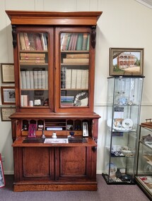
Furniture - Secretaire with Bookcase - the Watson Family of Wodonga
This secretaire once stood proudly in the de Kerilleau homestead at Wodonga. The homestead had been built for William Huon, son of the early pastoralist Paul Huon, in 1870 and named after the family's ancestral estate in France. The original lease of the Wodonga Run was granted to Paul Huon as No. 202 on 7th February 1837, about a year after his cousin Charles Huon had squatted on the land. Kenneth Darnton Watson bought de Kerilleau homestead in 1922 where the Watson family lived for three generations, caring for the land and serving the Wodonga community. Kenneth, his son Ian Darnton Watson and his grandson John Kenneth Darnton Watson all served on the Wodonga Council. John Kenneth Darnton Watson was born on 28 August 1960 in Wodonga. After completing his primary schooling locally, he boarded at Geelong College from 1973. John joined the rowing crews, starting in the 8th VIII crew and reaching the 1st VIII crew in 1978. He received multiple House colours awards for cross country, athletics and rowing and received School colours for rowing. On completion of his schooling, John spent some time jackarooing before studying farm management at Marcus Oldham College. He then returned home to de Kerilleau, Wodonga to manage the family property. In 1984 John married Christine Honybun, daughter of David Lewis Honybun and Marian Josephine Edkins. John and Christine had three sons. John was community minded and involved in a number of local organisations such as Apex and agricultural societies. He was elected to Wodonga City Council in 1997, serving until 2004. Due to increased pressure on available land to cater for the growth of Wodonga, some of the property was sold and in 2003 John donated 200 ha of Huon Hill ‘s western slopes to the City of Wodonga. After this time, he moved away from farming to become a Hungry Jack's franchisee. In 2009, the hard decision was made to sell de Kerilleau and John and his family moved into Wodonga. After sadly losing Christine to cancer in 2017, John became a member and Deputy Chairperson of the Albury Wodonga Regional Cancer Centre Trust Fund Board and Ambassador for the Sunshine Walk. Tragically after his own cancer battle, John Kenneth Darnton Watson passed away on 24 August 2023, aged 62 years following a life of service to the Wodonga community.This item is significant because it was owned by a prominent Wodonga family and came from a Historic Homestead in WodongaA secretaire with bookcase made of cedar. The bottom section has two cupboards with shelves. These doors support the desk when it is fully opened. Above this section is one large drawer, the front of which opens by pressing a small internal button on each side. The open drawer reveals a desk with a leather writing mat and several compartments. The desk is topped by a book shelf with 3 adjustable shelves. It has lockable glass doors.watson family wodonga, de kerilleau homestead, john watson -
 Wodonga & District Historical Society Inc
Decorative object - Silver Tray from John Kenneth Darnton Watson, Wodonga
This silver tray was donated by the family of John Watson and was used when they lived in de Kerilleau Homestead for three generations. de Kerilleau Homestead was built for William Huon, son of the early pastoralist Paul Huon, in 1870 and named after the family's ancestral estate in France. The original lease of the Wodonga Run was granted to Paul Huon as No. 202 on 7th February 1837, about a year after his cousin Charles Huon had squatted on the land. Kenneth Darnton Watson bought de Kerilleau homestead in 1922 where the Watson family lived for three generations, caring for the land and serving the Wodonga community. Kenneth, his son Ian Darnton Watson and his grandson John Kenneth Darnton Watson all served on the Wodonga Council. John Kenneth Darnton Watson was born on 28 August 1960 in Wodonga. After completing his primary schooling locally, he boarded at Geelong College from 1973. John joined the rowing crews, starting in the 8th VIII crew and reaching the 1st VIII crew in 1978. He received multiple House colours awards for cross country, athletics and rowing and received School colours for rowing. On completion of his schooling, John spent some time jackarooing before studying farm management at Marcus Oldham College in Geelong, Victoria. He then returned home to de Kerilleau, Wodonga to manage the family property. In 1984 John married Christine Honybun, daughter of David Lewis Honybun and Marian Josephine Edkins. John and Christine had three sons. John was community minded and involved in a number of local organisations such as Apex and agricultural societies. He was elected to Wodonga City Council in 1997, serving until 2004. Due to increased pressure on available land to cater for the growth of Wodonga, some of the property was sold and in 2003 John donated 200 ha of Huon Hill‘s western slopes to the City of Wodonga. After this time, he moved away from farming to become a Hungry Jack's franchisee. In 2009, the hard decision was made to sell de Kerilleau and John and his family moved into Wodonga. After sadly losing Christine to cancer in 2017, John became a member and Deputy Chairperson of the Albury Wodonga Regional Cancer Centre Trust Fund Board and Ambassador for the Sunshine Walk. Tragically after his own cancer battle, John Kenneth Darnton Watson passed away on 24 August 2023, aged 62 years following a life of service to the Wodonga community.This item is significant because it was owned by a prominent Wodonga family and came from a Historic Homestead in WodongaA circular silver tray with an embossed design around the outer edge.watson family wodonga, de kerilleau homestead, john watson, peter charlesworth -
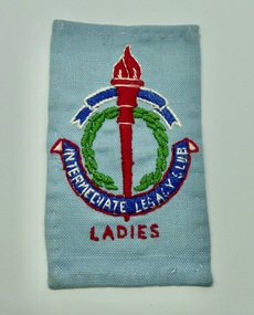 Melbourne Legacy
Badge, Intermediate Legacy Club Ladies Cloth Badge
An example of a Melbourne Ladies Intermediate Legacy Club Badge that was stitched onto clothes. ILC was formed from junior legatees who had become too old for the usual junior legatee activities. It was most active from the 1930s to 1950s. This badge came from a donation of material from a former Junior Legatee, Valma Hutchinson (nee Wigg). She was involved with the Ladies ILC. The badge of Legacy is the Torch and Wreath of Laurel. The Torch signifies the undying flame of service and sacrifice of those who gave their lives for their country. The Wreath of Laurel is the symbol of our remembrance of them. Background: The ILC was formed in 1929. The idea of the club sprang from those boys who had outgrown the Junior Legacy Club. In the early days it fielded a lacrosse team and it was this that mainly held the members together. Enthusiasm wained after a few years as it lacked a solid objective. The answer came from one of its members and in 1938 they founded the Don Esses Club. This was a club for the children of incapacitated ex-servicemen which met every Thursday night at 7.30 run by the ILC members. The name came from the signallers' code Disabled Servicemen's Sons. During the second world war 80% of the members of the ILC enlisted in the services. Leaving only 8 members that could not join due to ill health or reserved occupations. They continued the Don Esses and whatever aid they could to Legacy. ILC members had always helped Legacy where possible including being camp leaders or camp staff, with the annual demonstrations, and coffee stalls at the ANZAC dawn service. Post second world war some ILC members were nominated into Legacy, others drifted away in civil occupations. It was found difficult to recruit new blood into the ILC and eventually membership waned when the boys from the Don Esses clubs found other youth activities to join. The ILC ceased to meet regularly in the mid fifties. However a strong comradeship still existed between members and they would meet in one anothers homes. Members were always ready to help the senior Legacy Club in any way in their power and still helped at Christmas parties and summer camps. ILC was a service rendering organisation and was self governing. Non-sectarian and non-political, the members were ex-junior legatees over 18 years of age. After serving in World War 2 members were eligible to become members of Legacy.A record of the cloth badge worn by Intermediate Legacy Club members.Cloth badge of the Legacy torch stitched on pale blue fabric containing the words Intermediate Legacy Club - Ladies.Embroidered with 'Intermediate Legacy Club - Ladies'ilc, membership -
 Ballarat Heritage Services
Photograph, Australian Ex-Prisoner of War Memorial, Ballarat, 04/11/2014
DESCRIPTIONColour photograph of a War Memorial designed by Peter Blizzard. The granite wall of the Australian Ex-Prisoners of War Memorial features a listing the names of Australian Prisoners and was opened on the 6th February 2004 by General Peter Cosgrove AM MC to recognise and remember over 36,000 Australians who became Prisoners of War during the Wars of the 20th Century. In 2008 the Memorial became the First Military Memorial of National Significance outside Canberra. The Memorial which was designed by Peter Blizzard OAM, symbolises that all Australian prisoners embarked on a journey to serve away from their homeland and acknowledges the hardship, deprivation, brutality, starvation and disease endured by Prisoners of War during their capture and the scars that many continued to endure upon their repatriation to Australia. Heritage Victoria describes the memorial in the following way" "A JOURNEY OF HONOUR, REMEMBRANCE AND HEALING - The Australian Ex-Prisoners of War Memorial is a dramatic and highly symbolic tribute to the sacrifice made by more than 35,000 young Australian service men and women in four theatres of war. At the heart of the monument is a stark, 130 metre long, highly polished black granite wall, engraved with the names of all Australian prisoners of war. The names on this 'honour roll' are listed in historical order from the Boer War in 1899, through to the Korean War in 1953. It is a testament to the contribution made by so many. Standing sentinel at the centre of the Memorial are six huge basalt obelisks, etched with the names of all the countries where Australians were held prisoner of war. The obelisks stand in a large reflective pool, set back from the central pathway, symbolising the distance that separated Australia's prisoners of war from their homes and their loved ones. Opposite the pool is a larger obelisk flanked by flagpoles and a ceremonial stone on which to lay wreaths. The central pathway is itself symbolic, with each of the paving stones cut in the shape of a railway sleeper. The pathway defines 'the journey' taken by the prisoners of war and the journey visitors take around the monument. At the end of the granite wall where the pathway ends, visitors face a large stone engraved simply 'Lest We Forget'. Water flows from beneath the stone, along the base of the granite wall and into the reflection pool in which the obelisks stand. This cycle of flowing water, symbolising spirituality, healing, cleansing, birth and rebirth, guides visitors on their journey through the Memorial."australian ex-prisoner of war memorial, peter blizzard, prisoner of war, ballarat north gardens -
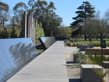 Ballarat Heritage Services
Photograph, Australian Ex-Prisoner of War Memorial, Ballarat, 2014, 04/11/2014
DESCRIPTIONColour photograph of a War Memorial designed by Peter Blizzard. The granite wall of the Australian Ex-Prisoners of War Memorial features a listing the names of Australian Prisoners and was opened on the 6th February 2004 by General Peter Cosgrove AM MC to recognise and remember over 36,000 Australians who became Prisoners of War during the Wars of the 20th Century. In 2008 the Memorial became the First Military Memorial of National Significance outside Canberra. The Memorial which was designed by Peter Blizzard OAM, symbolises that all Australian prisoners embarked on a journey to serve away from their homeland and acknowledges the hardship, deprivation, brutality, starvation and disease endured by Prisoners of War during their capture and the scars that many continued to endure upon their repatriation to Australia. Heritage Victoria describes the memorial in the following way" "A JOURNEY OF HONOUR, REMEMBRANCE AND HEALING - The Australian Ex-Prisoners of War Memorial is a dramatic and highly symbolic tribute to the sacrifice made by more than 35,000 young Australian service men and women in four theatres of war. At the heart of the monument is a stark, 130 metre long, highly polished black granite wall, engraved with the names of all Australian prisoners of war. The names on this 'honour roll' are listed in historical order from the Boer War in 1899, through to the Korean War in 1953. It is a testament to the contribution made by so many. Standing sentinel at the centre of the Memorial are six huge basalt obelisks, etched with the names of all the countries where Australians were held prisoner of war. The obelisks stand in a large reflective pool, set back from the central pathway, symbolising the distance that separated Australia's prisoners of war from their homes and their loved ones. Opposite the pool is a larger obelisk flanked by flagpoles and a ceremonial stone on which to lay wreaths. The central pathway is itself symbolic, with each of the paving stones cut in the shape of a railway sleeper. The pathway defines 'the journey' taken by the prisoners of war and the journey visitors take around the monument. At the end of the granite wall where the pathway ends, visitors face a large stone engraved simply 'Lest We Forget'. Water flows from beneath the stone, along the base of the granite wall and into the reflection pool in which the obelisks stand. This cycle of flowing water, symbolising spirituality, healing, cleansing, birth and rebirth, guides visitors on their journey through the Memorial."australian ex-prisoner of war memorial, prisoner of war, ballarat north gardens, peter blizzard -
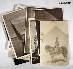 Bendigo Military Museum
Postcard - POSTCARDS, PHOTOGRAPHIC WW1, C.WW1
The cards revolve around "Hannah FIRTH". See also Cat. No. 4048.10P for more cards. .1) Addressed to "Hannah" from "Clarry (Peanuts)". .2) To "Dear Hannah, April 13th 7.30pm". Not signed off but from same person as .1) & .3). .3) Addressed "Dear" from "Dillon (Clarry)". .4) To "Dear Hannah" from "Yours ERIC". .5) There is no to or from but mentions "ERIC". .6) - .9) all are written on rear in large purple writing with the following: "Love to Hannah x x" "To Hannah with Love x x x" "With the Australian Contingent in Eygpt" "Love to Hannah x x" .10) Addressed to "Mrs H. FIRTH 18 Brunswick St Morley Leeds Yorkshire". The date on card is unclear. .11) On rear in red "No 33 - some of the nurses in their quarters at an Australian Casualty Clearing Station". .12) On rear in fine print "Patriotic Series No. 22" Across both 4048.10P & 4049.12P there is two other addresses for "MISS H. FIRTH". 1. 28 Young St Fitzroy, Melbourne. 2. 2 Turner St Abbotsford, Melbourne.Twelve photograph postcards of different scenes revolving around “Hannah”.1) & .2) Postcards, colour, centre has oval shape with British flag and all around are 11 smaller flags with country name on. In gold speckled writing top & bottom "From A. 10th Field Coy Engineers. On rear in black pen extensive letters. .3) Postcard, colour, centre has horse shoe with Australian & British flags. In same speckled gold writing as .1) & .2). On horseshoe in black pen "Good luck to Hannah & Clarence". .4) Postcard, black & white, showing a ship, at the bottom printed "TROOPSHIP HORORATA". On rear short letter in purple. .5) Postcard, sepia, showing soldier on horseback at the Pyramids & Sphinx. On rear brief letter in pencil. .6) Postcard, sepia, showing a street scene which appears to be a place called "Muski" in Eygpt. Brief note on rear in purple. .7) Postcard, sepia, showing domed building, re the "Blue Mosque". Brief note on back in purple. .8) Postcard, sepia, scene over buildings being "View from the Citadel". Brief note on the back in purple. .9) Postcard, sepia, showing a sailing craft on a river being "Felluca on the Nile". .10) Postcard, colour, hand drawn, shown a flag flower arrangement, centre in an arrow through a heart. Address on rear in black. .11) Postcard, black & white, showing a group of nurses. Card was put out by the "Aust Comforts Fund". .12) Postcard, colour, drawn showing six different nations soldiers carrying flags.photographs, postcards, hannah -
 Eltham District Historical Society Inc
Photograph, Hume and Hovell passed here at Seymour 28 Oct 1824, Spring Excursion, Hume and Hovell's 1824 expedition (Part 2), 26 October 1997, 26/10/1997
[article by Diana Bassett-Smith in EDHS Newsletter No. 117, November 1997:] MONUMENT HUNTING THE HUME AND HOVELL WAY - Sunday October 26 1997 dawned bright and very warm. Some twenty-five members, complete with picnic baskets, met outside the Eltham Library awaiting the Cobb and Co. large coach which would be taking us on the second leg of our travels along the route of the early explorers Hume and Hovell. Stephen West was our very good driver for the day. He would be guided around the circuitous route by Russell Yeoman who had made a detailed study, not only of the intended route, but of the story of these two explorers. During the trip Russell regaled us with poetry, quotations from the Journals and the History of the Shire of Seymour, "The New Crossing Place" by Martindale, 1982, (now Mitchell Shire due to the recent amalgamations). We headed towards the Hume Highway via Greensborough and Cooper Street and proceeded north to our first stop, noting on the way Monument Hill in the distance which is near Kilmore and, according to Russell, well worth the effort to visit as the view across the valley is magnificent. Past Sunday Creek Valley, Mt Piper and Mt Disappointment, all traversed and noted and named by them. We passed through Tallarook, then onto Seymour where we took photos of the monument telling us that Hume and Hovell had passed through on the 28th of October 1824. We also deviated down Hume and Hovell Road viewing deer and emu farming and the Bellbourie property now a sanctuary. Leaving Seymour behind we travelled up the Avenel Road to the Avenel monument, pyramidal in design of four reducing square blocks with a sharply pointed peak, erected in 1924 in memory of the 1824 exploration. The day was warming up and the countryside showing the dryness of the current drought. A parallel note had been made in their journal too of 1824 of the drought appearance of the country they were traversing. At Seven Creeks, Euroa we stopped for some minutes to check the monument placed 20th November 1924 to commemorate their passage on the 29th December 1824. More photos. Russell had pointed out the abrupt termination of the distant ranges which is noted in their journal. The next monument is beside the road at the entrance to Honey Suckle Creek Caravan Park, Violet Town. The squarish shaped monument some eight feet high is topped with a simple steel cross, and was to mark the date of 28th December 1824 and built for the 20th November 1924. By now it was 12.20 and nearly lunchtime as we drove along the Warranbayne Road to Roach's Road, monument hunting without success. Though there is a large, what appears to be an old timber sign which was hard to read, maybe this was the lost monument. In many of the paddocks hay had been cut and baled or was being cut, what a contrast to the rugged country they had passed through which was smoky from the fires of the natives burning off. By 1.00 pm we were at Benalla and pulled up beside the park where abundant beds of roses filled the air with their scent and the smell of barbecued food twitched the nostrils whilst the cheerful sounds of other picnickers could be heard throughout the park. We left the bus and collected up our picnics, dispersed to the various tables and enjoyed the shade from the various European trees. 2.00 pm and we were on the road again driving along the Benalla, Mansfield, Yea road. The Swanpool monument states that they passed four miles south and returned three miles north. Then we stopped at the Barjarg monument which notes that they camped near this spot. It is again a pyramidal monument and this time topped with a steel arrow indicating their route of the 29th November 1824. Half an hour later we came to another monument, again with a steel arrow marker on top and the plaque dated the 2nd of 12th 1824. Erected on the 12th of 12th 1924. "They blazed the way that we might inherit the land." Another square based and needle topped monument appeared at Yarck near Yea and this plaque records the date of 3 December 1824. Near McGuigans Road Russell related that the expedition had lost a dog but it had found them next day, the dog was apparently torn by a kangaroo. A short while later Russell reminded us here of the problems they encountered in crossing the Goulburn River near Molesworth where banks were high, water deep and wide. "Good coat of grass but quite dry due to drought". At Yea we stopped for afternoon tea and raided the last of our picnics and looked at the monument to their journey of 1824, situated at a corner of the gardens near the bowling green. No photo – we were out of film. We returned home via Kinglake West and Whittlesea past the Yan Yean Reservoir, not full. 5.00 pm back at Eltham we emptied out of the bus and everyone, including Joan Cole, collected their things, Joan also had the major souvenir of the day, a large carp she had picked up from the river bank, her cat was in for a great feast. The day was made so interesting by the informed commentary which Russell provided. His background knowledge of the route and nature of the journey could only have come from many hours of reading and driving the area. Thank you to Russell and to everyone who made the day so informative and pleasurable. Colour photographactivities, hume and hovell, monument, seymour -
 Eltham District Historical Society Inc
Photograph, Spring Excursion, Hume and Hovell's 1824 expedition (Part 2), 26 October 1997, 26/10/1997
[article by Diana Bassett-Smith in EDHS Newsletter No. 117, November 1997:] MONUMENT HUNTING THE HUME AND HOVELL WAY - Sunday October 26 1997 dawned bright and very warm. Some twenty-five members, complete with picnic baskets, met outside the Eltham Library awaiting the Cobb and Co. large coach which would be taking us on the second leg of our travels along the route of the early explorers Hume and Hovell. Stephen West was our very good driver for the day. He would be guided around the circuitous route by Russell Yeoman who had made a detailed study, not only of the intended route, but of the story of these two explorers. During the trip Russell regaled us with poetry, quotations from the Journals and the History of the Shire of Seymour, "The New Crossing Place" by Martindale, 1982, (now Mitchell Shire due to the recent amalgamations). We headed towards the Hume Highway via Greensborough and Cooper Street and proceeded north to our first stop, noting on the way Monument Hill in the distance which is near Kilmore and, according to Russell, well worth the effort to visit as the view across the valley is magnificent. Past Sunday Creek Valley, Mt Piper and Mt Disappointment, all traversed and noted and named by them. We passed through Tallarook, then onto Seymour where we took photos of the monument telling us that Hume and Hovell had passed through on the 28th of October 1824. We also deviated down Hume and Hovell Road viewing deer and emu farming and the Bellbourie property now a sanctuary. Leaving Seymour behind we travelled up the Avenel Road to the Avenel monument, pyramidal in design of four reducing square blocks with a sharply pointed peak, erected in 1924 in memory of the 1824 exploration. The day was warming up and the countryside showing the dryness of the current drought. A parallel note had been made in their journal too of 1824 of the drought appearance of the country they were traversing. At Seven Creeks, Euroa we stopped for some minutes to check the monument placed 20th November 1924 to commemorate their passage on the 29th December 1824. More photos. Russell had pointed out the abrupt termination of the distant ranges which is noted in their journal. The next monument is beside the road at the entrance to Honey Suckle Creek Caravan Park, Violet Town. The squarish shaped monument some eight feet high is topped with a simple steel cross, and was to mark the date of 28th December 1824 and built for the 20th November 1924. By now it was 12.20 and nearly lunchtime as we drove along the Warranbayne Road to Roach's Road, monument hunting without success. Though there is a large, what appears to be an old timber sign which was hard to read, maybe this was the lost monument. In many of the paddocks hay had been cut and baled or was being cut, what a contrast to the rugged country they had passed through which was smoky from the fires of the natives burning off. By 1.00 pm we were at Benalla and pulled up beside the park where abundant beds of roses filled the air with their scent and the smell of barbecued food twitched the nostrils whilst the cheerful sounds of other picnickers could be heard throughout the park. We left the bus and collected up our picnics, dispersed to the various tables and enjoyed the shade from the various European trees. 2.00 pm and we were on the road again driving along the Benalla, Mansfield, Yea road. The Swanpool monument states that they passed four miles south and returned three miles north. Then we stopped at the Barjarg monument which notes that they camped near this spot. It is again a pyramidal monument and this time topped with a steel arrow indicating their route of the 29th November 1824. Half an hour later we came to another monument, again with a steel arrow marker on top and the plaque dated the 2nd of 12th 1824. Erected on the 12th of 12th 1924. "They blazed the way that we might inherit the land." Another square based and needle topped monument appeared at Yarck near Yea and this plaque records the date of 3 December 1824. Near McGuigans Road Russell related that the expedition had lost a dog but it had found them next day, the dog was apparently torn by a kangaroo. A short while later Russell reminded us here of the problems they encountered in crossing the Goulburn River near Molesworth where banks were high, water deep and wide. "Good coat of grass but quite dry due to drought". At Yea we stopped for afternoon tea and raided the last of our picnics and looked at the monument to their journey of 1824, situated at a corner of the gardens near the bowling green. No photo – we were out of film. We returned home via Kinglake West and Whittlesea past the Yan Yean Reservoir, not full. 5.00 pm back at Eltham we emptied out of the bus and everyone, including Joan Cole, collected their things, Joan also had the major souvenir of the day, a large carp she had picked up from the river bank, her cat was in for a great feast. The day was made so interesting by the informed commentary which Russell provided. His background knowledge of the route and nature of the journey could only have come from many hours of reading and driving the area. Thank you to Russell and to everyone who made the day so informative and pleasurable. Colour photographactivities, hume and hovell, bridge -
 Eltham District Historical Society Inc
Photograph, Spring Excursion, Hume and Hovell bus tour Stage 2, Seymour, Benalla; 26 Oct 1997, 26/10/1997
MONUMENT HUNTING THE HUME AND HOVELL WAY (Newsletter No. 117, November 1997, by Diana Bassett-Smith) Sunday October 26 1997 dawned bright and very warm. Some twenty-five members, complete with picnic baskets, met outside the Eltham Library awaiting the Cobb and Co. large coach which would be taking us on the second leg of our travels along the route of the early explorers Hume and Hovell. Stephen West was our very good driver for the day. He would be guided around the circuitous route by Russell Yeoman wh9 had made a detailed study, not only of the intended route, but of the story of these two explorers. During the trip Russell regaled us with poetry, quotations from the Journals and the History of the Shire of Seymour, "The New Crossing Place: by Martindale, 1982, (now Mitchell Shire due to the recent amalgamations). We headed towards the Hume Highway via Greensborough and Cooper Street and proceeded north to our first stop, noting on the way Monument Hill in the distance which is near Kilmore and, according to Russell, well worth the effort to visit as the view across the valley is magnificent. Past Sunday Creek Valley, Mt Piper and Mt Disappointment, all traversed and noted and named by them. We passed through Tallarook, then onto Seymour where we took photos of the monument telling us that Hume and Hovell had passed through on the 28th of October 1824. We also deviated down Hume and Hovell Road viewing deer and emu farming and the Bellbourie property now a sanctuary. Leaving Seymour behind we travelled up the Avenel Road to the Avenel monument, pyramidal in design of four reducing square blocks with a sharply pointed peak, erected in 1924 in memory of the 1824 exploration. The day was warming up and the countryside showing the dryness of the current drought. A parallel note had been made in their journal too of 1824 of the drought appearance of the country they were traversing. At Seven Creeks, Euroa we stopped for some minutes to check the monument placed 20th November 1924 to commemorate their passage on the 29th December 1824. More photos. Russell had pointed out the abrupt termination of the distant ranges which is noted in their journal. The next monument is beside the road at the entrance to Honey Suckle Creek Caravan Park, Violet Town. The squarish shaped monument some eight feet high is topped with a simple steel cross, and was to mark the date of 28th December 1824 and built for the 20th November 1924. By now it was 12.20 and nearly lunchtime as we drove along the Warranbayne Road to Roach's Road, monument hunting without success. Though there is a large, what appears to be an old timber sign which was hard to read, maybe this was the lost monument. In many of the paddocks hay had been cut and baled or was being cut, what a contrast to the rugged country they had passed through which was smoky from the fires of the natives burning off By 1.00 pm we were at Benalla and pulled up beside the park where abundant beds of roses filled the air with their scent and the smell of barbecued food twitched the nostrils whilst the cheerful sounds of other picnickers could be heard throughout the park. We left the bus and collected up our picnics, dispersed to the various tables and enjoyed the shade from the various European trees. 2.00 pm and we were on the road again driving along the Benalla, Mansfield, Yea road. The Swanpool monument states that they passed four miles south and returned three miles north. Then we stopped at the Barjarg monument which notes that they camped near this spot. It is again a pyramidal monument and this time topped with a steel arrow indicating their route of the 29th November 1824. Half an hour later we came to another monument, again with a steel arrow marker on top and the plaque dated the 2nd of 12th 1824. Erected on the 12th of 12th 1924. "They blazed the way that we might inherit the land." Another square based and needle topped monument appeared at Yarck near Yea and this plaque records the date of 3 December 1824. Near McGuigans Road Russell related that the expedition had lost a dog but it had found them next day, the dog was apparently torn by a kangaroo. A short while later Russell reminded us here of the problems they encountered in crossing the Goulburn River near Molesworth where banks were high, water deep and wide. "Good coat of grass but quite dry due to drought". At Yea we stopped for afternoon tea and raided the last of our picnics and looked at the monument to their journey of 1824, situated at a corner of the gardens near the bowling green. No photo – we were out of film. We returned home via Kinglake West and Whittlesea past the Yan Yean Reservoir, not full. 5.00 pm back at Eltham we emptied out of the bus and everyone, including Joan Cole, collected their things, Joan also had the major souvenir of the day, a large carp she had picked up from the river bank, her cat was in for a great feast. The day was made so interesting by the informed commentary which Russell provided. His background knowledge of the route and nature of the journey could only have come from many hours of reading and driving the area. Thank you to Russell and to everyone who made the day so informative and pleasurable. Diana Bassett-Smith. Record of the Society's history of activities - Spring 1997 excursionRoll of 35mm colour negative film, 6 stripsFuji 200shire of eltham historical society, activities, pretty hill, seymour, benalla, hume and hovell, monuments -
 Eltham District Historical Society Inc
Photograph, Spring Excursion, Hume and Hovell bus tour Stage 2, Seymour, Benalla; 26 Oct 1997, 26/10/1997
MONUMENT HUNTING THE HUME AND HOVELL WAY (Newsletter No. 117, November 1997, by Diana Bassett-Smith) Sunday October 26 1997 dawned bright and very warm. Some twenty-five members, complete with picnic baskets, met outside the Eltham Library awaiting the Cobb and Co. large coach which would be taking us on the second leg of our travels along the route of the early explorers Hume and Hovell. Stephen West was our very good driver for the day. He would be guided around the circuitous route by Russell Yeoman wh9 had made a detailed study, not only of the intended route, but of the story of these two explorers. During the trip Russell regaled us with poetry, quotations from the Journals and the History of the Shire of Seymour, "The New Crossing Place: by Martindale, 1982, (now Mitchell Shire due to the recent amalgamations). We headed towards the Hume Highway via Greensborough and Cooper Street and proceeded north to our first stop, noting on the way Monument Hill in the distance which is near Kilmore and, according to Russell, well worth the effort to visit as the view across the valley is magnificent. Past Sunday Creek Valley, Mt Piper and Mt Disappointment, all traversed and noted and named by them. We passed through Tallarook, then onto Seymour where we took photos of the monument telling us that Hume and Hovell had passed through on the 28th of October 1824. We also deviated down Hume and Hovell Road viewing deer and emu farming and the Bellbourie property now a sanctuary. Leaving Seymour behind we travelled up the Avenel Road to the Avenel monument, pyramidal in design of four reducing square blocks with a sharply pointed peak, erected in 1924 in memory of the 1824 exploration. The day was warming up and the countryside showing the dryness of the current drought. A parallel note had been made in their journal too of 1824 of the drought appearance of the country they were traversing. At Seven Creeks, Euroa we stopped for some minutes to check the monument placed 20th November 1924 to commemorate their passage on the 29th December 1824. More photos. Russell had pointed out the abrupt termination of the distant ranges which is noted in their journal. The next monument is beside the road at the entrance to Honey Suckle Creek Caravan Park, Violet Town. The squarish shaped monument some eight feet high is topped with a simple steel cross, and was to mark the date of 28th December 1824 and built for the 20th November 1924. By now it was 12.20 and nearly lunchtime as we drove along the Warranbayne Road to Roach's Road, monument hunting without success. Though there is a large, what appears to be an old timber sign which was hard to read, maybe this was the lost monument. In many of the paddocks hay had been cut and baled or was being cut, what a contrast to the rugged country they had passed through which was smoky from the fires of the natives burning off By 1.00 pm we were at Benalla and pulled up beside the park where abundant beds of roses filled the air with their scent and the smell of barbecued food twitched the nostrils whilst the cheerful sounds of other picnickers could be heard throughout the park. We left the bus and collected up our picnics, dispersed to the various tables and enjoyed the shade from the various European trees. 2.00 pm and we were on the road again driving along the Benalla, Mansfield, Yea road. The Swanpool monument states that they passed four miles south and returned three miles north. Then we stopped at the Barjarg monument which notes that they camped near this spot. It is again a pyramidal monument and this time topped with a steel arrow indicating their route of the 29th November 1824. Half an hour later we came to another monument, again with a steel arrow marker on top and the plaque dated the 2nd of 12th 1824. Erected on the 12th of 12th 1924. "They blazed the way that we might inherit the land." Another square based and needle topped monument appeared at Yarck near Yea and this plaque records the date of 3 December 1824. Near McGuigans Road Russell related that the expedition had lost a dog but it had found them next day, the dog was apparently torn by a kangaroo. A short while later Russell reminded us here of the problems they encountered in crossing the Goulburn River near Molesworth where banks were high, water deep and wide. "Good coat of grass but quite dry due to drought". At Yea we stopped for afternoon tea and raided the last of our picnics and looked at the monument to their journey of 1824, situated at a corner of the gardens near the bowling green. No photo – we were out of film. We returned home via Kinglake West and Whittlesea past the Yan Yean Reservoir, not full. 5.00 pm back at Eltham we emptied out of the bus and everyone, including Joan Cole, collected their things, Joan also had the major souvenir of the day, a large carp she had picked up from the river bank, her cat was in for a great feast. The day was made so interesting by the informed commentary which Russell provided. His background knowledge of the route and nature of the journey could only have come from many hours of reading and driving the area. Thank you to Russell and to everyone who made the day so informative and pleasurable. Diana Bassett-Smith. Record of the Society's history of activities - Spring 1997 excursionRoll of 35mm colour negative film, 6 stripsFuji 200shire of eltham historical society, activities, pretty hill, seymour, benalla, hume and hovell, monuments