Showing 22468 items matching "parkes"
-
 Falls Creek Historical Society
Document - S.E.C. Asked For Registered Number Of Vehicles Parked Overnight
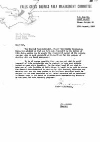
Bob (Herman) Hymans (a former member of the Royal Netherlands Navy) was born in Bloemendaal, Holland on 30th September 1922. During World War II he fought against the Japanese in the Dutch East Indies (now Indonesia) and was imprisoned in Changi and on the Burma Railway. After gaining qualifications as a Ski Instructor, Bob arrived in Falls Creek in July 1950. Working as an Instructor and Supervisor at Bogong Lodge, Bob decided his future was in accommodation. He was successful in negotiating an indenture for land from the State Electricity Commission (SEC). It took Bob two years to build his Grand Coeur Chalet but, tragically, it was burned down in August 1961. Bob also built the first Chairlift in Australia. This was a single chairlift and the structure was built from wooden electricity poles. He was constantly full of new ideas and proposals for the village. Bob Hymans died on 7th July 2007. This Collection of documents and letters tells the story of Bob's endeavours to develop Falls Creek into the ski village it is today.This letter is significant because it reflects the relationship between Bob Hymans and the Management Committee.A letter from the Management Committee pointing out that Mr Hymans has failed to provide his car registration number to the SEC as requested. If not provided his vehicle will not be able to park his vehicle overnight within Falls Creek.falls creek tourist area management committee, bob hymans, falls creek administration -
 Bendigo Historical Society Inc.
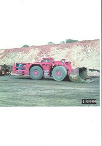
Photograph - Kangaroo Flat Gold Mine Collection: mining equipment, 21st May 1999
A bogger is a heavy-duty piece of equipment used in underground mining to transport rocks, ore, and other materials from the digging face to processing facilities or loading areas. A bogger operator is an individual who controls the machinery used to transport materials.Colour photocopy of original photo. Image shows red load haul dump loader, pictured parked on a mine road at the Kangaroo Flat Gold Mine site. Date stamp on bottom RH corner: 21/5/1999.western mining corporation, goldmining, capping, shaft, mining regulations, kangaroo flat gold mine, 1999 -
 Melbourne Tram Museum
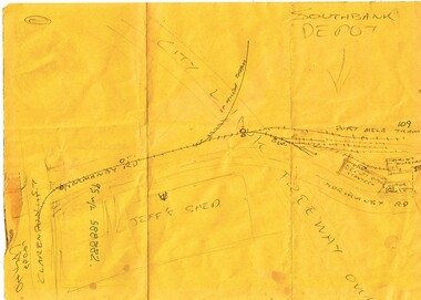
Drawing, John Prideaux, "Southbank Depot", c2000
Hand make sketch on a AMWU yellow A4 sheet of paper advertising a protest meeting, with a sketch of Southbank depot, showing a simplified track layout, Jeff's shed, building layout, car parks and the City Link Freeway over.trams, tramways, southbank depot, depots, unions -
 Melbourne Tram Museum
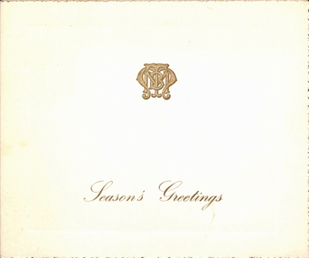
Ephemera - Christmas Card, Melbourne & Metropolitan Tramways Board (MMTB), 1970's
Christmas card, printed - 8 pages featuring a MMTB logo (gold) on the front cover and a photo of the Wattle Park Golf course, from the MMTB. Has a serrated edge with a slight silver finish. Not dated. Two copies held.trams, tramways, mmtb, christmas, greetings cards, wattle park -
 Lakes Entrance Historical Society
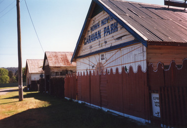
Photograph - Nowa Nowa Caravan Park, 1999
Colour photograph of a building at the Nowa Nowa Caravan Park, a weatherboard building with gable corrugated iron roof. Also in photograph two buildings, one of which was Hodder's Store and the other which used to be the bakehouse. Nowa Nowa Victoriacamping, buildings -
 Lakes Entrance Historical Society
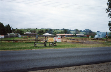
Photograph, Holding M, Whiters Camp Park, 1994c
Colour copy photograph showing the cleared land which was previously part of Whiters Camp Park, in preparation for the building of a complex of attractive brick units in Roadknight Street. Estate agent's advertising signs on fence. Lakes Entrance Victoriaresort, tourism, land development -
 University of Melbourne, Burnley Campus Archives
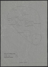
Plan, The Old Cypress Bed, 1987-1993
(1) Plant plan dated 15.8.1987 on tracing paper, and plan of bed only. (2) Site inventory and analysis Group 3 Parks and Gardens III August 1993, on tracing paper. (3) Rough plant plan in pencil.gardens, cypress, burnley gardens 150 year anniversary -
 Bendigo Historical Society Inc.
Photograph - BASIL MILLER COLLECTION: CHARING CROSS, BENDIGO
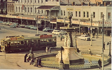
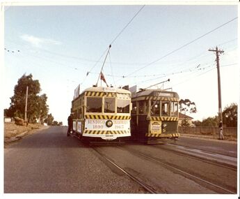
BHS CollectionColoured post card, view of Alexandra Fountain and Pall Mall. Tram in forefront. View towards Pall Mall (north) Beehive and Ezywalkin buildings. Cars angle parked along Pall Mall. Approx. 1950/60's.Charing Cross, Bendigo, Victoria. Charing Corrs, with its historic Alexandra Fountain, is the hub of Bendigo from which roads radiate to most parts of the city. Plastichrome - Murfett Publishers P 62710.basil miller, bendigo tramways, charing cross bendigo -
 Bendigo Historical Society Inc.
Photograph - BASIL MILLER COLLECTION: 2 TRAMS DESTINATION EAGLEHAWK
BHS CollectionColor photo of 2 trams parked in middle of road side by side, tram on right showing destination as Eaglehawk. On back 'Copyright by the Tramway Museum Society of Victoria' stamped in purple ink, pencil marks showing '21/36'.person, individual, basil miller -
 Canterbury History Group
Photograph - View looking through the lane way between No. 114 and No. 112 Maling Road towards the Post Office, Jan Pigot, 27/03/1993 12:00:00 AM
Coloured photograph of a view looking towards Maling Road and the Post Office from the red brick lane way that runs between No. 114 and No. 112 Maling Road. This is taken from the car park behind the Maling Road shops.canterbury, maling road, shops, brickwork, laneways -
 Chelsea & District Historical Society Inc
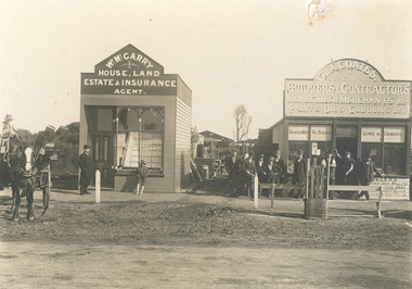
Photograph - Shops in Chelsea, 1914
Black and white photo of two shops in Chelsea: Wm. McGarry, Estate Agents and G & A Coates Builders & Contractors. There are a group of men standing in front of the shops and young boy with shoes. A horse and wagon carrying timber is parked on the road.WM. McGARRY - HOUSE, LAND ESTATE & INSURANCE AGENT. G & A COATES - BUILDERS & CONTRACTORS - IRON & TIMBER MERCHANTS &c. PAINTS, OILS, COLOURS &c. GLASS CUT TO SIZES - LIME & CEMENTshops, chelsea, mcgarry, g & a coates -
 Ithacan Historical Society
Photograph, Frikes, Ithaca, c1970s
As the closest port to the mainland and neighbouring island Lefkada, Frikes was historically a trading port, supplying produce and merchandise to northern Ithaca. Today it is more a quiet fishing village which comes alive during the summer months with cafes and taverns. In summer tourist yachts moor at Frikes and a ferry service operates to Lefkada. A coloured photograph of he harbour at Frikes. Thee is a stone and concrete breakwater in the foreground where three fishing boats and a yacht are moored. A sedan is parked on the breakwater. Buildings are around the water's edge in the middle distance against a backdrop of mountains. ports, frikes -
 Kew Historical Society Inc
Plan, Melbourne & Metropolitan Board of Works : Borough of Kew : Detail Plan No.1302, 1910
The Melbourne and Metropolitan Board of Works (MMBW) plans were produced from the 1890s to the 1950s. They were crucial to the design and development of Melbourne's sewerage and drainage system. The plans, at a scale of 40 feet to 1 inch (1:480), provide a detailed historical record of Melbourne streetscapes and environmental features. Each plan covers one or two street blocks (roughly six streets), showing details of buildings, including garden layouts and ownership boundaries, and features such as laneways, drains, bridges, parks, municipal boundaries and other prominent landmarks as they existed at the time each plan was produced. (Source: State Library of Victoria)This plan forms part of a large group of MMBW plans and maps that was donated to the Society by the Mr Poulter, City Engineer of the City of Kew in 1989. Within this collection, thirty-five hand-coloured plans, backed with linen, are of statewide significance as they include annotations that provide details of construction materials used in buildings in the first decade of the 20th century as well as additional information about land ownership and usage. The copies in the Public Record Office Victoria and the State Library of Victoria are monochrome versions which do not denote building materials so that the maps in this collection are invaluable and unique tools for researchers and heritage consultants. A number of the plans are not held in the collection of the State Library of Victoria so they have the additional attribute of rarity.Original survey plan, issued by the MMBW to a contractor with responsibility for constructing sewers in the area identified on the plan within the Borough of Kew. The plan was at some stage hand-coloured, possibly by the contractor, but more likely by officers working in the Engineering Department of the Borough and later Town, then City of Kew. The hand-coloured sections of buildings on the plan were used to denote masonry or brick constructions (pink), weatherboard constructions (yellow), and public buildings (grey). The absence of buildings and or property in Kew facing the Yarra is the most notable feature of this plan. Walmer Street and its bridge stretched, then and now, from Studley Park Road to Victoria Street, Richmond. On the Richmond side of the Yarra, there was evidence in 1904 of industry (‘Wool shed’; Soap Works’) and entertainment (‘Skittle Alley’). In reality, another Plan (No.1303) shows Chinese Gardens bordering the Yarra on the Kew side and buildings in Young Street.melbourne and metropolitan board of works, detail plans, mmbw 1302, cartography -
Ringwood and District Historical Society
Documents, Ringwood and North Ringwood Community Fairs - documents 1995, 7-May-95
Group includes Ringwood Art Society and Norwood Park Centre, including promotions update.Documents about the organisation for the Ringwood and North Ringwood community fairs - May 1995. 10pp. -
 Eltham District Historical Society Inc
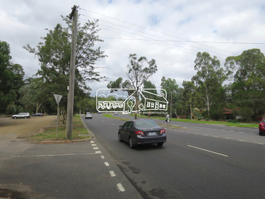
Photograph, Jim Connor, Main Road, Eltham, 14 Jan 2017
Eltham Gateway, Looking north along Main Road near Eltham Lower ParkTomorrow's history documented todayeltham, jim connor collection, main road, eltham gateway -
 Eltham District Historical Society Inc
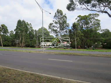
Photograph, Jim Connor, Main Road, Eltham, 14 Jan 2017
Eltham Gateway, Looking south along Main Road near Eltham Lower ParkTomorrow's history documented todayeltham, jim connor collection, main road, eltham gateway -
 Eltham District Historical Society Inc
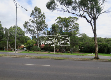
Photograph, Jim Connor, Main Road, Eltham, 14 Jan 2017
Eltham Gateway, View to 559 Main Road, Eltham opposite Eltham Lower ParkTomorrow's history documented todayeltham, jim connor collection, main road, eltham gateway -
 Eltham District Historical Society Inc
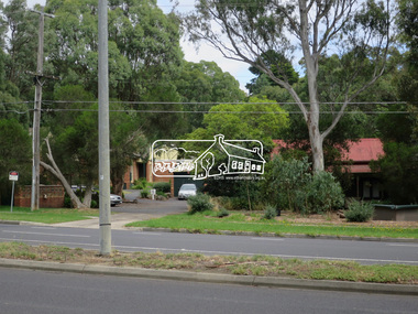
Photograph, Jim Connor, Main Road, Eltham, 14 Jan 2017
Eltham Gateway, View to 559 Main Road, Eltham opposite Eltham Lower ParkTomorrow's history documented todayeltham, jim connor collection, main road, eltham gateway -
 Eltham District Historical Society Inc
Photograph, Jim Connor, Main Road, Eltham, 14 Jan 2017
Eltham Gateway, View to 559 Main Road, Eltham opposite Eltham Lower ParkTomorrow's history documented todayeltham, jim connor collection, main road, eltham gateway -
 Eltham District Historical Society Inc
Photograph, Jim Connor, Main Road, Eltham, 14 Jan 2017
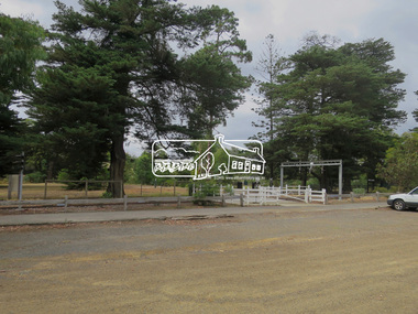
Eltham Gateway, Front carpark at Eltham Lower Park looking at Diamond Valley RailwayTomorrow's history documented todayeltham, jim connor collection, main road, eltham gateway, diamond valley railway, eltham lower park -
 Eltham District Historical Society Inc
Photograph, Jim Connor, Avenue of Honour, Main Road, Eltham, 14 Jan 2017
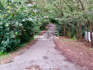
Eltham Gateway, Wingrove Park Trail opoosite Dalton Street intersection with Main RoadTomorrow's history documented todayeltham, jim connor collection, main road, eltham gateway, avenue of honour, dalton street, wingrove park trail -
 Eltham District Historical Society Inc
Photograph, Jim Connor, Avenue of Honour, Main Road, Eltham, 14 Jan 2017
Eltham Gateway, Wingrove Park Trail opoosite Dalton Street intersection with Main RoadTomorrow's history documented todayeltham, jim connor collection, main road, eltham gateway, avenue of honour, dalton street, wingrove park trail -
 Eltham District Historical Society Inc
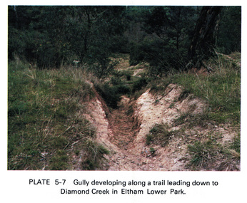
Work on paper (Sub-Item) - Photograph, Gully developing along a trail leading down to the Diamond Creek in Eltham Lower Park
Colour photograph of a gully on a trail leading down to the Diamond Creek in Eltham Lower Park. eltham, diamond creek, gully, eltham lower park, trail -
![Letter - Correspondence - Letter, Alan & Rosemary Bell, [Bell family at Grace Park], 2020c](/media/collectors/4f729f5697f83e03086015b8/items/62b56a0539450362aacc9a63/item-media/63182d8b823216272c24f3b6/item-fit-380x285.jpg) Greensborough Historical Society
Greensborough Historical SocietyLetter - Correspondence - Letter, Alan & Rosemary Bell, [Bell family at Grace Park], 2020c
Notes on the community activities of Ron Bell in Greensborough, particularly the Grace Park area in the 1960s (?)1 p. photocopied handwritten lettergrace park, bell family, ron bell -
 Greensborough Historical Society
Booklet, Parks Victoria et al, Plenty Gorge Park fire recovery, 15/04/2020
Community update on rehabilitation of the section of Plenty Gorge Park affected by a bushfire in December 20196 p. text and colour photographs and mapplenty gorge park, bushfires, blue lake, yellow gum park, plenty -
 Greensborough Historical Society
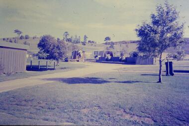
Slide - Photograph, John Ramsdale, Park and kiosk, Whittlesea: Slide 63, 1990s
Photograph shows farm park and kiosk on Plenty Road Whittlesea. This is the future site of Funfields.Part of the John Ramsdale collection of slides and audio visual material.Colour photograph scanned from slide.No maker's marks. No caption on slide.funfields, plenty road whittlesea -
 Greensborough Historical Society
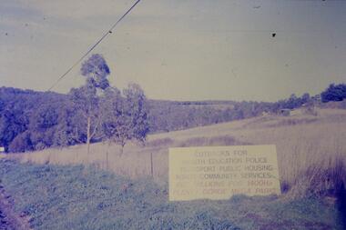
Slide - Photograph, John Ramsdale, Sign - Gorge Road: Slide 76, 1990s
Photograph shows an anti- Plenty Gorge Park sign in Gorge Road South MorangPart of the John Ramsdale collection of slides and audio visual material.Colour photograph scanned from slide.No maker's marks. No caption on slide.plenty gorge, plenty gorge metropolitan park, melbourne and metropolitan board of works -
 Greensborough Historical Society
Folder of documents, Nepean Street - fact or fiction?, by Peter Simmenauer, 2018_09
Record of ownership of 216 Nepean Street Greensborough 1916-1997, Grace Park areaPhotocopies of four Certificates of Title and other land documents, with summary of land ownership 1916-1997nepean street greensborough, grace park -
 Greensborough Historical Society
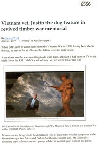
Article, Vietnam vet, Justin the dog feature in revived timber war memorial, by Carolyn Webb, 23/04/2019
Bill Cantwell, Vietnam veteran, was the model for the new sculptures in Greensborough War Memorial Park 1 p. transcribed article with colour photographbill cantwell, greensborough war memorial park, homefront sculptures, homefront project -
 Greensborough Historical Society
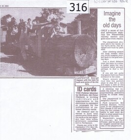
Newspaper clipping, Diamond Valley Leader, Imagine the old days, 10/09/1985
News article relating the opening of a 'gold mining' site and wooden train at Westerfolds Park.Photocopy of article from Diamond Valley News 1985. Includes photograph of children on miniature train.westerfolds park, gold mine, parks, playgrounds, george haslam, yarra river