Showing 25665 items
matching plenty-township-estate
-
 Ringwood and District Historical Society
Administrative record - Rate Books, Borough of Ringwood Valuation & Rate Cards for 1944-49 (Assessments 1435 -1440), March 2012
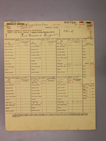
Originally stored at Ringwood Council offices, then taken to PROV.Only source of ratepayers in the Borough of RingwoodDigital imagesPine Cres, Ringwood. Pinemont Estate. For John Pratt, Ngaio Dawson, Phyllis Dawson, Arthur Batrouney and Harold Johnson. -
 City of Moorabbin Historical Society (Operating the Box Cottage Museum)
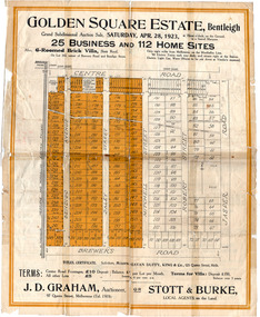
Flyer - Golden Square Estate, Bentleigh, 1923
Land sales in the Municipality of Moorabbin increased when the train line from the City to Frankston was electrified.Example of the progress of the Municipality of MoorabbinThe train line from the city to Frankston was electrified which intensified the sale in the municipality of Moorabbin, particularly land which was in the vicinity of the railway stations.Golden Square Estate, Bentleigh - J. D. Graham, Stott & Burke - 25 business sites and 112 home sitescentre road, brewers road, jasper road, robert street, mitchell street, daley street, bendigo avenue, auction, real estate, moorabbin, bentleigh -
 Port Melbourne Historical & Preservation Society
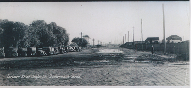
Photograph - Lorimer Street at Ingles Street, Fisherman's Bend, 1930s
Photographic copy of "Lorimer St at Ingles St, Fisherman's Bend" early 1930s. A panoramic photo with added title in white. On left are vehicles parked at the Sandridge Golf Club (formerly the Victoria Golf Club which moved to Cheltenham in 1927)On rear in ink : from "Ginger" Weedon. Formally (sic) from Dunstan Parade Garden City H/C Estatefishermans bend, sport, built environment - domestic, weedon, lorimer street -
 Greensborough Historical Society
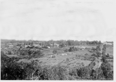
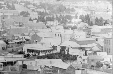
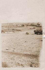
Photograph - Digital image, Panorama Overlooking Greensborough, 1925c
Photograph shows the view overlooking the Greensborough township in the first half of the 20th Century. It shows the rural nature of the area.Digital copy of black and white photograph.greensborough -
 Stawell Historical Society Inc
Photograph, Upper Main Street Stawell with the Patrick & Sloane Street corner in the lower middle of Photo 1880
Stawell Township - Upper Main Street 1880. Patrick Street Sloane Street corner lower middle of Photo.stawell -
 Buninyong & District Historical Society
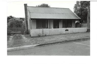
Photograph - Original B/W Photograph, Miner's cottage built on land owned by Thomas Hiscock in Learmonth St west, Buninyong, April 1994
The weatherboard cottage was built in the 1860's on land owned by Thomas Hiscock, the discoverer of gold near Buninyong township.The weatherboard cottage was built in the 1860's on land owned by Thomas Hiscock, the discoverer of gold near Buninyong. It is a good example of a miner's cottage of its era.B/W photo of Miner's cottage, Learmonth St west, Buninyong. Streetscape photo taken in 1993 of a weatherboard building with picket fence.miners cottage, house, building, weatherboard, thomas hiscock, hiscock, buninyong, learmonth st -
 Buninyong & District Historical Society
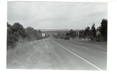
Photograph - B/W photograph, Mr. Clive J. Brooks, Eastern approach to Buninyong Midland Highway 1994, April 1994
Approach to township of Buninyong prior to amalgamation with Ballarat City Council. Buninyong shire town sign visible in foreground.Record of Buninyong Shire prior to amalgamationBlack and white photograph of the Eastern approach to Buninyong from the Midland Highway taken from opposite Ballantrae looking West. In left foreground is an example of Buninyong shire town sign before amalgamation 1994.buninyong shire, midland highway, street scene -
 Sunbury Family History and Heritage Society Inc.
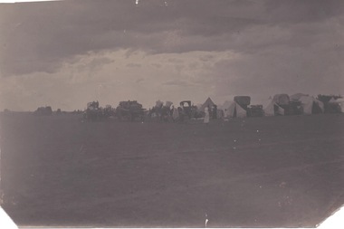
Photograph, Cam, 1900
From information written on the back of the image, this was 'a Dutch camp in township' which was there in 1900. There is no indication as to where the camp actually was.A dark sepia photograph of a campsite in on open are with tens and some large horse-drawn vehicles set up. -
 Sunbury Family History and Heritage Society Inc.
Photograph
A portrait view overlooking Sunbury township taken from a hill above the Goonawarra vineyard at the eastern end of the settlement. A sepia photograph with a cream frame of a portrait view of a rural landscape.sunbury township., goonawarra winery -
 Eltham District Historical Society Inc
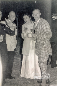
Photograph, New Year at John Harcourt's, Clay Nuneham, Eltham, 1954, 1954
Mr and Mrs Morrell and Mr Cliff Bush of "Yallambie", Lower Plenty.Reproduction of black and white photographcelebrations, clay nuneham, cliff bush, john harcourt, morrell, yallambie -
 Greensborough Historical Society
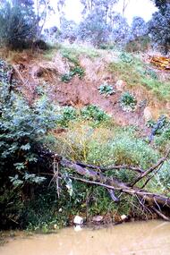
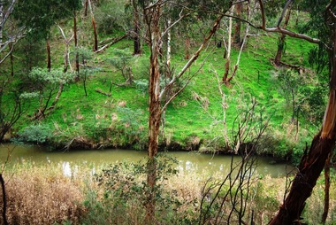
Slide - Photograph, John Ramsdale, Poor riverbank management: Slide 62, 1990s
Photograph shows poor riverbank management along the banks of the Plenty River.Part of the John Ramsdale collection of slides and audio visual material.Colour photograph scanned from slide.No maker's marks. No caption on slide.plenty river -
 Greensborough Historical Society
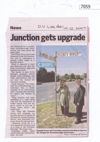
Newspaper Clipping, Junction gets upgrade, 19/12/2007
Article on the upgrade of the Diamond Creek Road and Plenty River Drive intersection. Black and white text, colour imageplenty river drive greensborough, diamond creek road greensborough -
 Greensborough Historical Society
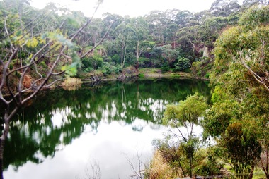
Photograph - Digital image, Marilyn Smith, Blue Lake 1, 19/06/2015
Blue Lake is in Yellow Gum Park in the Plenty Gorge, north of Greensborough.Digital copy of colour photographsyellow gum park, blue lake, plenty gorge park -
 Greensborough Historical Society
Photograph - Digital image, Marilyn Smith, Blue Lake 2, 19/06/2015
Blue Lake is in Yellow Gum Park in the Plenty Gorge, north of Greensborough.Digital copy of colour photographsyellow gum park, blue lake, plenty gorge park -
 Greensborough Historical Society
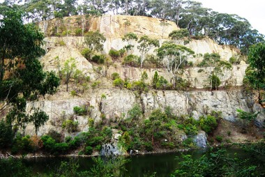
Photograph - Digital image, Marilyn Smith, Blue Lake: the escarpment, 19/06/2015
Blue Lake is in Yellow Gum Park in the Plenty Gorge, north of Greensborough.Digital copy of colour photographsyellow gum park, blue lake, plenty gorge park -
 Greensborough Historical Society
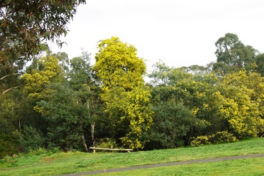
Photograph - Digital image, Marilyn Smith, Partington's Flat, 16/08/2015
Partington's Flat. These photos show the Plenty River Trail at Partington's Flat.Digital copy of colour photographspartingtons flat, plenty river trail -
 Greensborough Historical Society
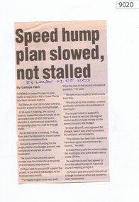
Newspaper - Newspaper Clipping, Speed hump plan slowed, not stalled, 07/05/2003
Speed hump plan for Old Eltham Road Lower Plenty 2003Newspaper clipping, text only.old eltham road lower plenty, speed humps, banyule -
 Whittlesea Historical Society Inc.
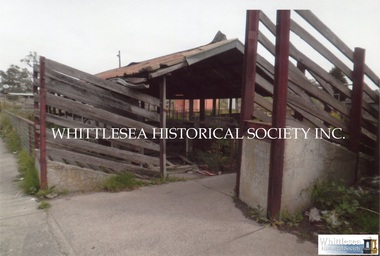
Photograph, Mernda Sale yards
2 photographs showing the Mernda Sale Yards in Plenty Road in Mernda.2 colour photographs, undated.mernda, sale yards, mernda sale yards, mernda market -
 Whitehorse Historical Society Inc.
Letter - Correspondence, Sale of Schwerkolt Cottage to the City of Nunawading, 1964
Photocopies: 1. Letter to Mary Schwerkolt from Charles C. Schwerkolt dated 24 September 1964 re sale of property to the City of Nunawading. 2. Letter to Charles C. from estate agent C.E.Carter and Son, estate agent, dated 23 March 1964 confirming verbal agreement with Town Clerk in respect of the property in Deep Creek Road.schwerkolt cottage, city of nunawading, schwerkolt, mary, schwerkolt, charles clarence victor, c.e. carter and son -
 Bendigo Historical Society Inc.
Document - MISS G ALICE JONES COLLECTION: ACCOUNT
The Liquidator Bendigo Amalgamated Goldfields Ltd. To Miss G. Alice Jones. Re Kruger's account. Pink paper dated July 16 to Aug. 27, 1926, and June 1929. Instructions to prepare proof of debt in Mr. Kruger's estate, work done to receive dividend and Statement re Kruger's estate. R492 Posted 29/6/1929 by B.F.the miss g. alice jones collection - account, bendigo amalgamated goldfields ltd, mr kruger, mr stanfield -
 Greensborough Historical Society
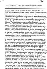
Article - Newspaper Clipping (copy), Jas Blackburn, The locality of Batman's Treaty with the Port Phillip natives, 09/01/1886
Text of a paper read before the Historical Society of Australia by Jas. Blackburn in 1886. Discusses Batman's Treaty with the Port Phillip traditional owners and the possible site of the signing - on the east side of the River Plenty, NW of Eltham andd 3 miles above the junction of the Plenty with the Yarra River.6p. text.john batman, batman's treaty, port phillip district, plenty river -
 City of Moorabbin Historical Society (Operating the Box Cottage Museum)
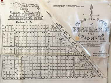
Document, photocopy of Plan of Beaumaris 1853, c1960
Beaumaris includes two early estates in the parish of Moorabbin developed by Josiah Holloway from 1852. Named Beaumaris Town and Beaumaris Estate (after the pastoral run in the area and ultimately after Beaumaris in Wales), the lots comprising them were marketed by Mr Holloway's suggesting that the railway was imminent and a canal would be built. The township developed slowly, a Post Office opened on 1 March 1868, but was replaced next month by Gipsy Village office (now Sandringham) In 1862 Beaumaris was one of the early settler communities within the boundaries of the Moorabbin District Roads Board , the region’s first local government authority. Beaumaris is a suburb in Melbourne, Victoria, Australia, 19 km south-east from Melbourne's central business district. .Since the Amalgamation of Councils 1994 the local government area is the City of Bayside which includes Brighton. A Photocopy of the Plan of Beaumaris 1853 A3moorabbin, county of bourke, brighton, beaumaris, pioneers, early settlers. market gardeners, cheltenham, king. john, holloway josiah, whorral charles, arthur’s seat road, nepean highway, morabbin district roads board, sandringham, mordialloc, mentone -
 Bendigo Historical Society Inc.
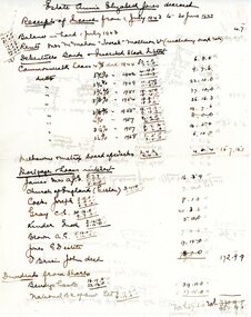
Document - G. ALICE JONES COLLECTION: ESTATE ANNIE ELIZABETH JONES
Thirteen pages of handwritten records relating to the estate of Annie Elizabeth Jones, including receipts of capital, receipts of income, expenditure of income, assets and liabilities.person, individual, g.alice jones -
 Bendigo Historical Society Inc.
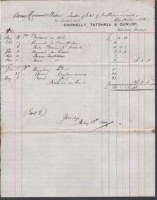
Document - CONNELLY, TATCHELL, DUNLOP COLLECTION: ACCOUNT ESTATE OF JOHN WATSON DECEASED
Account rendered by Connelly, Tatchell & dunlop to the trustees of the Estate of John Watson deceased and Mrs. Watson & others. For services given in 1901, account for 63.0.0.business, legal, john watson, john watson, connelly, tatchell & dunlop -
 Bendigo Historical Society Inc.
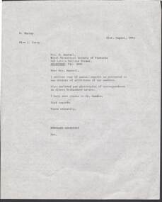
Document - MRS M MAXWELL, ROYAL HISTORICAL SOCIETY OF VICTORIA, 21 August 1972
Document, Mrs. M. Maxwell, Royal Historical Society of Victoria, Melbourne, Enclosing annual reports to Members and photocopies Re; Albert Richardson Estatedocument -
 Bendigo Historical Society Inc.
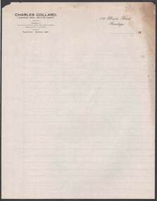
Document - CAMBRIDGE PRESS COLLECTION; LETTER PAPER - CHARLES COLLARD
Letter paper with printed letterhead. Date line ends 19- -. Charles Collard, Licenced Real Estate Agent, 116 Olinda Street, bendigo.business, printers, cambridge press, cambridge press collection, charles collard -
 Bendigo Historical Society Inc.
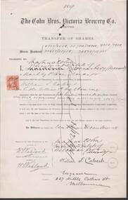
Document - COHN BROTHERS COLLECTION: SHARE TRANSFER CERTIFICATE 1894
Cohn Brothers Transfer of Shares from Executor of estate of Maldemar Levy to Magnus Cohn dated 10th Dec 1894. Duty Stamp attached.bendigo, industry, cohn bros brewery, maldemar levy. -
 Port Melbourne Historical & Preservation Society
Document - 1998 Calendar, Frank Gordon Estate Agents, c. 1920
Letterboxed in 1997Calendar for 1998 (2 copies) with colour-enhanced photo of Station Pier, steamers and the Ozone c1920, distributed by advertising estate agents Frank Gordonbusiness and traders, piers and wharves - station pier, frank gordon and co, ps ozone, real estate -
Port Melbourne Historical & Preservation Society
Document - Contract of Sale for Lot 35 Beacon Cove, Port Melbourne, 1996
Lot 35 is now titled 18 Park Square, Beacon Cove, Port MelbourneWhite folder with black spiral binding & Beacon Cove logo. Folder contains the Contract for Sale of Real Estate for Lot 35 Beacon Cove.built environment - domestic, department of planning and development, park square, beacon cove, mirvac -
Bendigo Historical Society Inc.
Map - PORTION OF ELMORE ESTATE, 19/10/1920
Map: Portion of Elmore Estate, Parishes of Warragamba and Diggorra, County of Bendigo. Parish plan Canvas backed ( number 143 in Map Cupboard 1)map, bendigo, rural, elmore estate , warragamba, diggorra , county of bendigo.