Showing 4161 items
matching postcards - photographs
-
 Mt Dandenong & District Historical Society Inc.
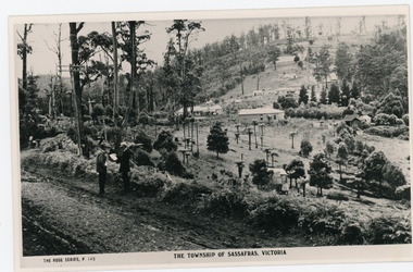
Photograph, The Township of Sassafras. Victoria, late 1940s
The township of Sassafras taken late 1940s. The man in the foreground in the trilby, carrying the rucksack is a Rose Series employee. He appears in many of the photos. Sassafras House can be seen in the centre of the picture.Black and white copy of a Rose Series postcard P. 145 showing two men stnding at the side of the road . Behind them is the early township of Sassafras.sassafras -
 Mt Dandenong & District Historical Society Inc.
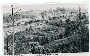
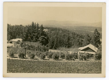
Photograph, Panorama at Sassafras, Victoria, c1930
Panorama of Sassafras with berry orchards clearly visible. c1930s.Black and white copy of Rose series postcard P. 2059 looking across sassafras.sassafras, rose series, berries, berry, orchard, agriculture -
 Mt Dandenong & District Historical Society Inc.
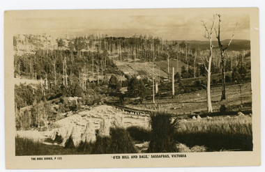
Photograph, 'O'er Hill and Dale,' Sassafras. Victoria, c1920
View of Sassafras showing many dead trees c1920s.Sepia coloured Rose Series postcard P. 153 looking down across Sassafras.On reverse REAL PHOTO POST CARD. THE "ROSE' SERIES DELUXE. PRODUCED IN AUSTRALIA. PUBLISHED BY 'THE ROSE STENOGRAPHS" Armadale. Victoriasassafras -
 Mt Dandenong & District Historical Society Inc.
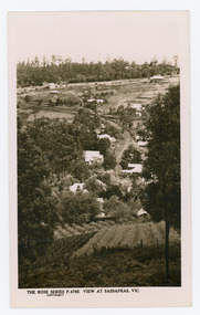
Photograph, View at Sassafras, Vic, c1930
View down the Main Street of Sassafras looking south with the Mechanics Institute in the centre of the picture. The raspberry patch in the foreground belonged to Woniger Hansen who built Mountain Rest (Rostrevor). The land was subdivided after his death in 1923. The raspberry patch is in the area of the current Mason Grove.Black and white Rose Series postcard P. 4765 looking south down the Main Street of Sassafras with buildings either side and berry patches in the foreground.On reverse POST CARD. THE "ROSE' SERIES DELUXE. A REAL PHOTOGRAPH PRODUCED IN AUSTRALIA. PUBLISHED BY 'THE ROSE STENOGRAPHS" Armadale. Victoria sassafras, rose series, rostrevor, woniger hansen, hansen, mechanics' institute, raspberry, raspberry crop, mountain rest, mason grove -
 Mt Dandenong & District Historical Society Inc.
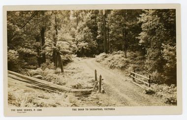
Photograph, The Road to Sassafras. Victoria
Rose Series postcard # P. 1588 showing a view of the road to Sassafras pre WW1.Sepia Coloured Rose Series post card P.1588 showing a stretch of unmade road passing over a simple bridge on the road to sassafras.On Front: THE ROSE SERIES, P. 1588 THE ROAD TO SASSAFRAS, VICTORIArose series, postcard, sassafras, road -
 Mt Dandenong & District Historical Society Inc.
Photograph, View Up Valley At Kalorama
John Lundy-Clarke grew up in the Kalorama/Mt Dandenong area and later in life (1972-74) began to write a comprehensive history of the area working from an original settlement map in an effort to cover all areas. The building in the centre of the photograph is 'Kia-Ora' guest house. Situated on Barber’s Road, ‘Kia-Ora’ was built in 1912 by George Barber. It was later leased by a Mrs Pemberthy. “Kia-Ora’ was one of four places connected when the telephone was brought into the district in 1912. The other places were ‘Mountjoy’, ‘Cherry Farm’ and ‘Callum House’. ‘Kia-Ora’ was burnt down in 1924. Black and White copy of section of a Rose Series postcard. Shows view up the valley at Kalorama with a decorative building centre middle of photograph. Handwritten description by John Lundy-Clarke on reverse.View up valley at Kalorama from near junction of Barbers and Doughty’s Rds. “Kia Ora” guest house in centre. Paynter’s “Iona” top left with “Kalorama” to its right. About 1912. Rose Series copied by JLC 1973.kalorama, kalorama valley, john lundy-clarke, barbers road, george barber, kia-ora, guest house, iona -
 Mt Dandenong & District Historical Society Inc.
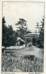
Photograph, Mt Dandenong North. Showing "Mountjoy"
The building with the white picket fence is the Beulah Tea Gardens opened by Eliza Hand c1904 at The Gap (now FiveWays). The building is still operating as a cafe. The Tourist Road does not yet exist. Old Coach Road comes into the picture from the right and the horse and cart is heading up Ridge Road. The elm trees can be seen on the left. The building up on the hill is the Mountjoy Guest House. ‘Mountjoy’ was built by the Paynter family in 1905. It had fourteen bedrooms, a dining room and sitting room, kitchen with a big wood burning range and verandahs on three sides. There were commanding views of the eastern ranges and the city to the west. Ellis Jeeves purchased ‘Mountjoy’ in 1908 and it soon became a popular tourist destination, the coach yards making it a centre of the district. ‘Mountjoy’ is a central feature of many photographs of Kalorama in the 1900s. The building burned down in 1975. Mt. Dandenong North was renamed Kalorama c1932.Black and white postcard showing a horse and cart on road between two buildings.On front ; Mt. Dandenong North. Showing "Mountjoy."postcard, mountjoy, guest house, beulah tea room, beulah, mt dandenong north, kalorama -
 Mt Dandenong & District Historical Society Inc.
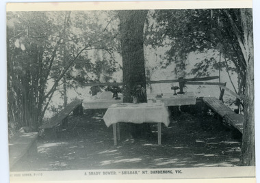
Photograph, Tea Tables at "Shiloah"
Originally the home of Isaac Jeeves, brother of Ellis Jeeves, ‘Shiloah’ was enlarged to take guests in the early 1900s. It was situated close to a beautiful fern gully and Isaac and his family capitalised on this by setting out walking tracks through the ferns. They charged 1/- to walk through and this included afternoon tea in a garden setting. ‘Shiloah’ was a popular tourist attraction but the making of the Olinda Creek Road destroyed the fern gullies and, by the 1930s, it was all finished. This photograph shows the tea tables at 'Shiloah' where Selina Jeeves and her daughter Elsie served afternoon tea to visitors.Black and white photograph taken from a Rose Series postcard showing tables set up in an exterior courtyard with bench seating.On front - Rose Series P. 170 A SHADY BOWER "SHILOAH" MT DANDENONG. VIC.shiloah, isaac jeeves the younger, guest house, afternoon tea, ferns, selina jeeves, elsie jeeves -
 Mt Dandenong & District Historical Society Inc.
Photograph, Walker's LOT 2
Harry Walker's property would have been run by his son William in 1922. When the CRB Road cut through the property William planted plum trees on the opposite side. These are visible in this photo. An extensive raspberry crop is in the foreground. The building over the road on the left hand side is the corn and produce store built by Edward John Price (son of Edward Joseph Price) to capitalise on the CRB Road cutting through the Price farm. John Lundy-Clarke grew up in the Kalorama/Mt Dandenong area and later in life (1972-74) began to write a comprehensive history of the area working from an original settlement map in an effort to cover all areas.Small black and white postcard showing a crop in foreground with a house to the right. A road passes through the centre with a house on the left on the opposite side of the road. A view to the ranges in the distance. A handwritten description on reverse by John Lundy-Clarke.View at Kalorama. View over LOT 2 (Walkers) 1922.harry walker, william walker, crb road, raspberry, edward john price, edward joseph price, produce store, store -
 Mt Dandenong & District Historical Society Inc.
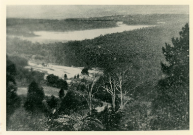
Photograph, Harmony Vale 1933
John Lundy-Clarke grew up in the Kalorama/Mt Dandenong area and later in life (1972-74) began to write a comprehensive history of the area working from an original settlement map in an effort to cover all areas. Harmony Vale was the name of the homestead built by early pioneer Jabez Richardson. The whole of the valley took on this name. The building lasted until 1933. The Silvan Dam was completed in 1932 and was full when this photograph was taken.Black and white photograph looking down over a forested area with a dam in the background. Copied from a Rose Series postcard c1933. Handwritten inscription on reverse by John Lundy-ClarkeRose Series photo of 1933 showing “Harmony Vale” still standing. Copied 1973 JLCharmony vale, silvan dam, jabez richardson -
 Mt Dandenong & District Historical Society Inc.
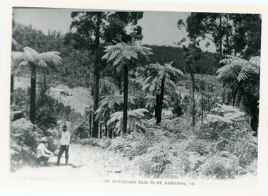
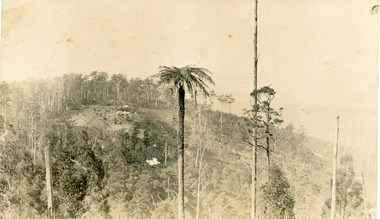
Photograph, View From Doughty's Road 1913
Mt Calvin, the homestead of Jeanie and Willie Richardson can be clearly seen in the clearing above the men in the picture. The white roof of the Barber homestead is on the right of the picture. A landslide in 1934 destroyed the tree ferned area. John Lundy-Clarke grew up in the Kalorama/Mt Dandenong area and later in life (1972-74) began to write a comprehensive history of the area working from an original settlement map in an effort to cover all areas.Black and white photograph that is a copy of a Rose series postcard titled 'The Picturesque Road to Mt. Dandenong. Vic.' It shows two men (probably Rose Series employees), one sitting and one standing at the edge of an unmade road. Large tree ferns line the roadside. Handwritten inscription on reverse by John Lundy-Clarke1913 View east from Doughty’s Road showing Jeannie Richardson’s home through the gap in the trees. A little to the right of and below centre of picture can be seen George Barber’s home with Barbers Road turning around the wagon shed that was a little up the hill from the house. The tree ferns in the picture were destroyed in the landslide of 1934. In the distance at the right can be seen F.M. Childs Homestead complex with the Richardson paddocks beyond it.mt calvin, jeanie richardson, willie richardson, george barber, landslide, tree fern -
 Mt Dandenong & District Historical Society Inc.
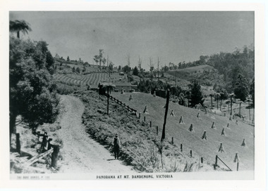
Photograph, View From Corner of Doughty's Road and Barbers Road 1913
John Lundy-Clarke grew up in the Kalorama/Mt Dandenong area and later in life (1972-74) began to write a comprehensive history of the area working from an original settlement map in an effort to cover all areas. Taken c1913, this photograph gives a clear indication of where significant buildings were located in relation to one another. Barbers Road is running through the picture with the guest house 'Kia-Ora' , built by George Barber in the centre. High on the skyline on the left is the 'Mountjoy' guesthouse, indicating the location of The Gap, or FiveWays. The small 'boxy' house above 'Kia-Ora' is 'Iona' built by the Paynter family who also built 'Mountjoy'. The Jeeves property 'Kalorama' is to the right of 'Iona' and this is the area you now look to from the FiveWays Lookout. The man in the photo is wearing a trilby hat so is probably a Rose Series employee - a feature in many Rose Series postcards.Black and white photograph that is a copy of Rose Series Postcard # 156. A man can be seen walking down an unmade road with haystacks to his right. Buildings and crops can be seen on the hillsides. Handwritten inscription on reverse by John Lundy-ClarkeView from corner of Doughty’s and Barbers Road 1913. “Kia Ora” in centre Paynter’s “Iona” near center skyline above “Kia Ora” with “Kalorama” on its right and Peter’s hut of the time below it among orchard trees. “Mountjoy” is on left skyline. W. Haye’s home is centre left. Hay paddock is Barbers Lot 25 Village Settlement.kia-ora, iona, kalorama, mountjoy, guesthouse, guest house, barbers road, doughty's road, paynter, jeeves, george barber -
 Mt Dandenong & District Historical Society Inc.
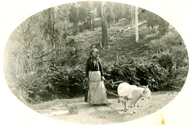
Photograph
Photograph likely taken on Childs Road in Kalorama in the early 1900s.Black and white photograph showing a woman with a long dress, apron and headscarf leading a got that is hitched to a small cart loaded with collected firewood. They are on a dirt road with bush above them. The photograph has been produced in postcard format with the picture in an oval in the centre of white frame.goat, wood collection, cart, wood, kalorama, childs road -
 Mt Dandenong & District Historical Society Inc.
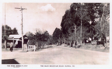
Photograph, The Main Mountain Road, Olinda, c1940
Copy of Rose Series Postcard #4797Copy of Rose Series Postcard #4797. View down Main Road Olinda towards Sassafras c1940s showing Post Office to the left.Three people visible in picture.rose series, post office, postcard, olinda, main road -
 Mt Dandenong & District Historical Society Inc.
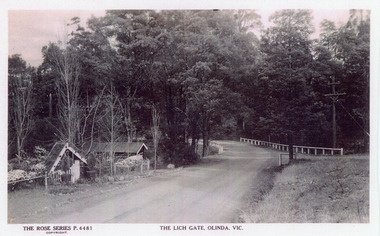
Photograph, The Lich Gate, Olinda, Vic, c1940s
Copy of Rose Series postcard #4481Copy of Rose Series postcard #4481. Mount Dandenong Road (Main Road) passing the picturesque Lich Gate on the left with Kenloch out of view on the right. c1940srose series, postcard, lich gate, olinda, kenloch, mt dandenong road, main road -
 Mt Dandenong & District Historical Society Inc.
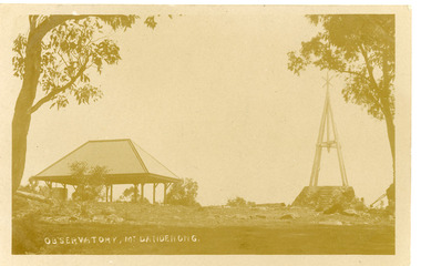
Photograph, OBSERVATORY, Mt Dandenong, Early 1900s
Postcard showing Mt Dandenong Trig Point Observatory on the RHS and a covered shelter on the LHS. Early 1900s.On front of postcard: OBERVATORY, MT DANDENONGtrig point, mt dandenong, mt dandenong observatory -
 Mt Dandenong & District Historical Society Inc.
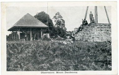
Photograph, Observatory, Mount Dandenong, early 1900s
Postcard showing the rock walled base of the Observatory and Trig Point on Mt Dandenong on the RHS and a roofed picnic shelter on the LHS. There are 6 men seated or standing on the rock base.Front of postcard: Observatory, Mount Dandenong. On back of postcard: Mason, Firth & McCutcheon, Printers, Melbourne.mt dandenong, mt dandenong observatory, trig point, mason, firth & mccutcheon -
 Mt Dandenong & District Historical Society Inc.
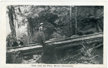
Photograph, View near the Falls, Mount Dandenong, early 1900s
Postcard showing a woman wearing a long dress and wide brimmed hat standing on a footbridge that crosses the Olinda Creek. Tree ferns and bushes are in the background. Taken early 1900s.On front of postcard: View near the Falls, Mount Dandenong. On back of post card: Mason, Firth & McCutcheon, Printers, Melbourne.mason, firth & mccutcheon, olinda falls, footbridge, bridge, mt dandenong, olinda creek -
 Mt Dandenong & District Historical Society Inc.
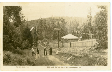
Photograph, The Road To The Falls Mt. Dandenong. Vic, early 1900s
Postcard showing two men and two women standing on Falls Road and two girls sitting on the grassy bank. This section of Falls Road would be below the current Tourist Road. A long fence has been built on the LHS and a house with a verandah is clearly seen. Early 1900s. The postcard appears to have been sent to Jim Woolrich from Auntie Florrie.On front of postcard: THE ROSE SERIES #152 THE ROAD TO THE FALLS, MT. DANDENONG. VIC. On back of postcard: Mr J Woolrich 58 Mountfield St Brunswick Wishing you many happy returns of the day from Auntie Florrie. falls road, olinda falls, mt dandenong, rose series -
 Mt Dandenong & District Historical Society Inc.
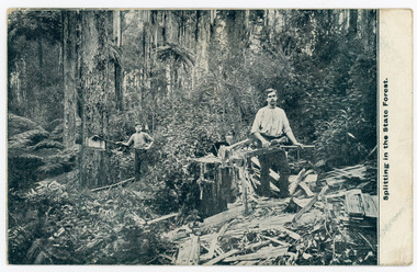
Photograph, Splitting In The State Forest, Early 1900s
Original postcard showing two men splitting wood in the forest at Mt Dandenong. They are using axes. Early 1900s.On front of postcard: Splitting in the State Forestwood chop, splitters, wood splitters, forest, mt dandenong, axes -
 Mt Dandenong & District Historical Society Inc.
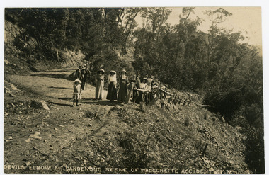
Photograph, Devils Elbow Mt. Dandenong Scene of Waggonette Disaster 27.12.1911, 1911
Original postcard showing a group of about 20 people surveying the scene of the Waggonette Disaster that occurred on the Coach Road at Devils Elbow on 27/12/1911. The accident occurred at Devil's Elbow where now the Old Coach Road and Jasper Road meet at a cliff face. John Lundy-Clarke made a ballad about the mishap. The waggonnette was returning from an excursion to the Brooklyn Guest House in Montrose. The horses were killed and passengers presumably injured (a doctor attended). See 'The Brooklyn Dray"On front of postcard: DEVILS ELBOW MT DANDENONG SCENE OF WAGGONETTE ACCIDENT 27.12.1911wagonette, wagon, accident, disaster, devil's elbow, devils elbow, john lundy-clarke, ballad, coach road, old coach road -
 Mt Dandenong & District Historical Society Inc.
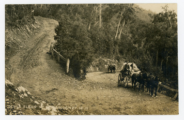
Photograph, Devils Elbow Mt Dandenong 27.12.1911, 1911
Original postcard showing two wagons coming up the hill to round the Devil's Elbow, scene of a wagon disaster where a wagon and horses went over the side on December 27th 1911. The first wagon is pulled by three horses and the second one horse with a man leading it.On front of postcard: DEVILS ELBOW MT DANDENONG 27.12.1911wagon, wagonette, devil's elbow, devils elbow, coach road, old coach road, mt dandenong -
 Mt Dandenong & District Historical Society Inc.
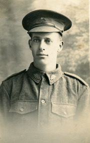
Photograph, Frank Gill, c1914
Photograph of Frank Gill in WW1 uniform. Postcard from "Kitchener Studio" Broadmeadows Camp. "Ainar Studio" Auburn.Handwritten on back: Frank Gill Mary's Boyfriend?frank gill -
 Mt Dandenong & District Historical Society Inc.
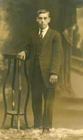
Photograph, Peter Johnston, 1914
... . Photograph is in postcard format made by R Yeoman 116 Bourke Street.... Photograph is in postcard format made by R Yeoman 116 Bourke Street ...Peter Johnston was the boyfriend of Iris Dorey, a daughter of the pioneering Dorey family. Iris ran the Quamby Cafe (now Cuckoo Restaurant) and later in life married Ted Woolrich from Woolrich Nursery. Peter was killed on active service during WW1 on May 15th 1918. Alice Dorey was the sister of Iris.Black and white studio photograph of Peter Johnston. Photograph is in postcard format made by R Yeoman 116 Bourke Street Melbourne.Handwritten on back: To Alice with love From Peter 18/3/14peter johnston, ww1, iris dorey, iris woolrich, woolrich nursery, alice dorey -
 Mt Dandenong & District Historical Society Inc.
Photograph, View of 'RangeView' Nursery, Olinda
Postcard format with old tree fern in foreground and Range View Nursery, Olinda on hill in background.Stamped on back of card in purple ink: E. Woolrich "Range View" Olinda Handwritten in pen: Olindarange view nursery, ted woolrich -
 Mt Dandenong & District Historical Society Inc.
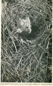
Photograph, Lyrebird's Nest and Young Lyrebird, Perrin's Creek, Olinda
Postcard depicting Lyrebird's Nest and Young Lyrebird, Perrin's Creek, Olinda.lyre bird, perrin's creek, olinda -
 Mt Dandenong & District Historical Society Inc.
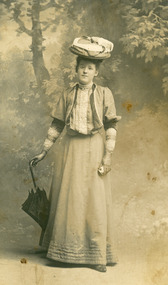
Photograph, Netty Grossman, early 1900s
... . Inscription on back indicates it is Netty Grossman. Photograph... is in postcard format. Probably early 1900s. Netty Grossman Photograph ...Studio portrait of well dressed young lady with parasol. Inscription on back indicates it is Netty Grossman. Photograph is in postcard format. Probably early 1900s.Written on back in pen: Netty Grossmannetty grossman -
 Mt Dandenong & District Historical Society Inc.
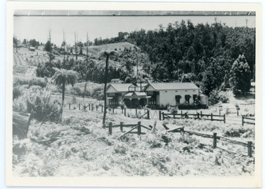
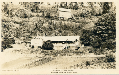
Photograph, Warwick Farm On Olinda Road
Information supplied by Stephen Trembath. Warwick Farm was established by my late grand parents Polly (nee Mary Ann Cole) and George Barratt and their 5 children George Jnr, William, James, John (my maternal Grand Father) and Teddy. Their story is told in a book "The wine of Courage" written in 1977 by N.M. Roberts ISBN 0 7223 1003. Their story started when their bank closed their doors on 13 April 1893 and they lost their cafe business in South Melbourne. Two days later, they were ready to head for a new start in Queensland when they saw in the morning paper that the Dandenong Ranges had been thrown open to land release to people. A few days later, having been granted land they headed to Ferntree Gully. From there they walked to the new holding in what would become Olinda. Then George with his sons help had to build a shelter for the family for the night. They chose to name the property "Warwick Farm". Work on the house started a few days later with help from neighbours Mr. Dodd, Mr Beattie, the O'Sheas and others. Come November, Ruby was born. Then bushfire burnt down the newly built house. Back to a bark hut until another house could be built. The new house became a guest house at the suggestion of a neighbour, when George couldn't sell timber and was waiting for crops. The first guests visited in 1898 and another baby, Percival, was born. ....................................................... It was George's son Jim, who was a skilled carpenter and axeman who extended the home to take from 12 to 30 guests. In 1950 Warwick Farm became the home of distinguished writer and journalist C.E.Sayers for a number of years.Photo Series Pictorial Postcard # 981 showing the property Warwick Farm on Olinda Road.Printed on back: PHOTO SERIES Pictorial Postcards. Published by S. Jamieson Bros. Alphington Vic. Phone Northcote 60warwick farm, olinda, postcard, photo series, olinda road, george barratt, barratt, guest house, guest house -
 Mt Dandenong & District Historical Society Inc.
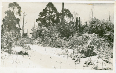
Photograph, Snowfall At Chalet Road, 1921
Postcard made for E. Woorich "Range View" Olinda showing Chalet Road in Olinda under snow in 1921.Printed on back in purple ink: E. Woorich "Range View" Olinda Handwritten in pen: 1921 snowfall at Chalet Road.range view nursery, e. woolrich, chalet road, snow, olinda -
 Mt Dandenong & District Historical Society Inc.
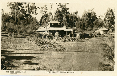
Photograph, The Chalet, Olinda, Victoria
Rose Series Postcard depicting "The Chalet" guest house at Olinda. Built c1906, The Chalet was situated at the southern corner of Chalet and McCarthy Roads. The building was destroyed by fire in 1935 and Ted Woolrich acquired the land.On front: The Rose Series P. 397the chalet, rose series, olinda, guesthouse, guest house