

Historical information
John Lundy-Clarke grew up in the Kalorama/Mt Dandenong area and later in life (1972-74) began to write a comprehensive history of the area working from an original settlement map in an effort to cover all areas.
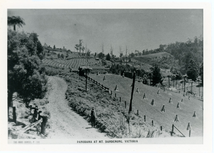
Taken c1913, this photograph gives a clear indication of where significant buildings were located in relation to one another.
Barbers Road is running through the picture with the guest house 'Kia-Ora' , built by George Barber in the centre. High on the skyline on the left is the 'Mountjoy' guesthouse, indicating the location of The Gap, or FiveWays. The small 'boxy' house above 'Kia-Ora' is 'Iona' built by the Paynter family who also built 'Mountjoy'. The Jeeves property 'Kalorama' is to the right of 'Iona' and this is the area you now look to from the FiveWays Lookout. The man in the photo is wearing a trilby hat so is probably a Rose Series employee - a feature in many Rose Series postcards.
Physical description
Black and white photograph that is a copy of Rose Series Postcard # 156. A man can be seen walking down an unmade road with haystacks to his right. Buildings and crops can be seen on the hillsides. Handwritten inscription on reverse by John Lundy-Clarke
Inscriptions & markings
View from corner of Doughty’s and Barbers Road 1913. “Kia Ora” in centre Paynter’s “Iona” near center skyline above “Kia Ora” with “Kalorama” on its right and Peter’s hut of the time below it among orchard trees. “Mountjoy” is on left skyline. W. Haye’s home is centre left. Hay paddock is Barbers Lot 25 Village Settlement.