Showing 10934 items
matching land
-
 Clunes Museum
Document - NEWSPAPER, CLUNES & TALBOT GUARDIAN, CLUNES GUARDIAN AND GAZETTE, 14/04/1939
SPECIAL EDITION .1 NEWSPAPER CLUNES GUARDIAN & GAZETTE, 14 APRIL, 1939. CLUNES CELEBRATES ITS 100TH BIRTHDAY. LISTS BUSINESSES 1863, LAND SETTLERS, HISTORY, CHURCHES, ITEMS FROM EARLY NEWSPAPERS. .2 PHOTOCOPY OF 1ST PAGE .3 NEWSPAPER CLUNES GUARDIAN & GAZETTE 14 APRIL, 1939. CENTENARY CELEBRATIONS OFFICIALLY OPENED BY SIR HARRY CHAUVEL IN THE PRESENCE OF 4000 PEOPLE.W. COOK WRITTEN IN PENCIL ON TOP R.H. CORNER1939, clunes 100th birthday, businesses 1863, clunes guardian & gazette, early land settlers, sir harry chauvel -
 The Beechworth Burke Museum Research Collection
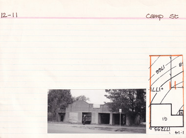
Card (Series) - Index Card, George Tibbits, Camp Street, Beechworth, 1976
George Tibbits, University of Melbourne. Faculty of Architecture, Building and Town & Regional PlanningIndex system that support the research for Beechworth : historical reconstruction / [by] George Tibbits ... [et al]Arranged by street names of BeechworthEach index card includes: street name and number of property, image of property, allotment and section number, property owners and dates of ownership, description of the property according to rate records, property floor plan with dimensions.beechworth, george tibbitsbeechworth, george tibbits -
 Eltham District Historical Society Inc
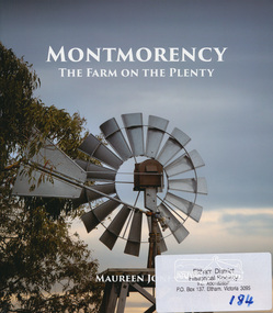
Book, Montmorency: The Farm on the Plenty by Maureen Jones, 2015
This book lays out the history of Montmorency from its earliest years as a hunting ground the Wurundjeri willam people, through its uptake by white settlers. Ownership of the land remained in the hands of one family for four generations spanning seventy years, before the land evolved through small farmlets into a suburb once part of the former Shire of Eltham, now part of Banyule City Council.Little has been written on the history of this hidden suburb of Melbourne. This book is significant in that it is the first major local history publication devoted to the suburb gathered particularly from local historical society archives and oral histories. ISBN 9780980807912montmorency -
 Rutherglen Historical Society
Document, 13/02/1998
When operational, the Gold Battery used cyanide in its processing processes. The land surrounding it required remediation before it could be handed over to Indigo Shire for public use. The land has since been planted with pasture and native plants. The Gold Battery has been restored to working condition, and can be viewed by collecting a ticket from the Rutherglen Wine Experience and Visitor Information Centre.Photocopy of letter relating to remediation works on the Gold Battery site.gold battery, gold processing, land remediation -
 Kew Historical Society Inc
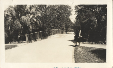
Photograph - In the 'Alexandra Gardens', Kew, 1927
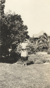
The Alexandra Gardens in Cotham Road, Kew were opened by the Governor of Victoria in 1910. The first curator of the gardens was George Pockett, who with his brother is credited with the layout of the gardens. The gardens were constructed on land originally owned by the King family of 'Madford' in Wellington Street. The land on which the gardens were developed was originally the back paddock of 'Madford' which was purchased by the Borough of Kew in 1906.A rare and early photograph of the gardens showing clearly the changes to the layout and planting during the 1920s. Small, sepia coloured photographic positive of a woman standing beside a path and bridge in the Alexandra Gardens in Cotham Road, Kew.Annotation verso: "Alexandra Gardens Kew 1927"parks and gardens -- kew (vic.), alexandra gardens -- kew (vic.), george pockett -
 Kew Historical Society Inc
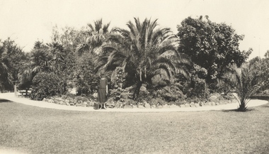
Photograph - In the 'Alexandra Gardens', Kew, 1927
The Alexandra Gardens in Cotham Road, Kew were opened by the Governor of Victoria in 1910. The first curator of the gardens was George Pockett, who with his brother is credited with the layout of the gardens. The gardens were constructed on land originally owned by the King family of 'Madford' in Wellington Street. The land on which the gardens were developed was originally the back paddock of 'Madford' which was purchased by the Borough of Kew in 1906.A rare and early photograph of the gardens showing clearly the changes to the layout and planting during the 1920s. Small, sepia coloured photographic positive of a woman with a suitcase standing on a gravel path in front of a semi-circular garden bed in the Alexandra Gardens in Cotham Road, Kew. The main plantings in the rock-bordered bed are varieties of palms. A wooden bridge can be seen to the woman's leftAnnotation verso: "Alexandra Gardens Kew 1927"parks and gardens -- kew (vic.), alexandra gardens -- kew (vic.), george pockett -
 Kew Historical Society Inc
Photograph - In the 'Alexandra Gardens', Kew, 1927
The Alexandra Gardens in Cotham Road, Kew were opened by the Governor of Victoria in 1910. The first curator of the gardens was George Pockett, who with his brother is credited with the layout of the gardens. The gardens were constructed on land originally owned by the King family of 'Madford' in Wellington Street. The land on which the gardens were developed was originally the back paddock of 'Madford' which was purchased by the Borough of Kew in 1906.A rare and early photograph of the gardens showing clearly the changes to the layout and planting during the 1920s. Small, sepia coloured photographic positive of a woman standing on the grass in front of a garden bed in the Alexandra Gardens in Cotham Road, Kew. The Centennial Rotunda, built in 1910, can be seen in the background. Annotation verso: "Alexandra Gardens Kew 1927"parks and gardens -- kew (vic.), alexandra gardens -- kew (vic.), george pockett -
 Melbourne Tram Museum
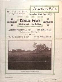
Ephemera - Real estate sale, Arthur Tucett & Son, "Labassa Estate" - Balaclava Road, East St Kilda, Nov. 1913
Pamphlet advertising the sale of land at the Labassa Estate, Balaclava Road 29-11-1913. Promotes the tram service, St Kilda Esplanade with a photo of PMTT 15 at the entry to Labassa at the corner of Orrong Road and Balaclava Road. Has a plan for the sub-division in to 46 allotments, terms of sale, and restrictions of what could be built on the land. The original Labassia Mansion is now owned by the National Trust.Demonstrates the style of land sale pamphlet including the availability of tram services to prospective purchasers.Pamphlet - folded - printed in two colours of cream coloured paper with photographs and plans.sale of land, trams, balaclava, balaclava road, real estate, labassa, orrong road -
 Federation University Art Collection
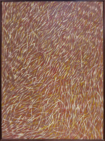
Painting - Artwork - painting, 'Grass Seeds' by Barbara Weir, 1999
Barbara Weir (b. 1945-03/01/2023) Born: In the region of Utopia, North East of Alice Springs, formerly known as Derry Downs Station Language: Anmatyerre and Alywarr Country: Atnwengerrp, Utopia Region, North East of Alice Springs, Northern Territory One of the Stolen Generation, Barbara Weir was removed from her Aboriginal family at the age of nine, and she was raised in a series of foster homes. Reuniting with her mother, Minnie Pwerle, in the 1960s, Weir eventually returned to her family territory of Utopia, 300 kilometres northeast of Alice Springs. Active in the local land rights movement of the 1970s Barbara Weir was elected the first woman president of the Indigenous Urapunta Council in 1985. Barbara’s career as an artist was inspired by the dynamic community of artists at Utopia and the work of her adopted auntie Emily Kame Kngwarreye. Highly experimental in her approach, Barabara Weir tried many mediums before travelling to Indonesia in 1994 with other artists to explore batik technique. She returned full of ideas on how to develop her own style which has since evolved to a more expressive abstract form. Grass Seed is part of her Dreamings and is associated with women’s ceremony and the activity of food gathering of local seeds, grasses, berries, potato, plum, banana, flowers and yams. This item is part of the Federation University Art Collection. The Art Collection features over 1000 works and was listed as a 'Ballarat Treasure' in 2007.Barbara Weir's paintings include representations of particular plants and "dreamings". Inspired by a small grass found in Utopia called Lyaw, Munyeroo or Pigsweed, Barbara's Grass Seed paintings consist of a series of small brush strokes that overlap and weave to create a swaying effect. This Dreaming tells the story of grass seed that is part of the bush tucker found in the region of Utopia. This seed is collected, crushed to a fine powder and is then used to make a bread, very similar to damper. The people of Utopia were still using this seed as late as the 1950s. During that time the seed grew in abundance but as the years passed there were very few good seeds to be found due to bullocks roaming the land and eating the grasses. The people then began to eat a substitute that the white man provided, and today very few Aboriginal people collect these seeds. art, artwork, barbara weir, aboriginal, dreaming, stolen generation, acrylic on linen -
 Ringwood and District Historical Society
Newspaper, Scrapbook Clipping, Library Collection, Ringwood, Victoria
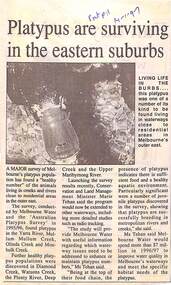
Newspaper Clipping from "The Post", 14 January 1997, Page 11, "Platypus are surviving in the eastern suburbs"'.A major survey of Melbourne's platypus population has found a "healthy number" of the animals living in creeks and rivers close to residential area in the outer east. Conservation and Land Management Minister, Marie Tehan, was present at the launching of the survey results, and spoke in detail about the results and the future planning and financial aid for the health of the Melbourne waterways. -
 Eltham District Historical Society Inc
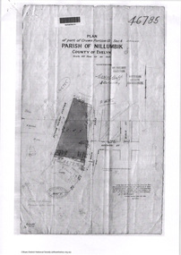
Document - Photocopy, Survey Fleld Notes of Part of Crown Portion 13, Section 4 at Eltham, Parish of Nillumbik, County of Evelyn, 7 May 1925
Portion of land bounded by: Main Road, Eltham Railway Station Application 46785 J.T. Robinson, Surveyor, 7 May 1925application 46785, arthur street, bible street, eltham, eltham railway station, luck street, main road, map, survey plan -
Glen Eira Historical Society
Document - Balaclava Road, 60, St Kilda East
Handwritten, undated, unattributed research notes briefly outlining the history of the land and house at Balaclava Road, 60, St Kilda East.balaclava road, orrong road, st kilda east, perrins james b, chaddesley, perrins elizabeth, andrew james b, sinclair sydney william, mordecai josh, mordecai clara, brosnan jean, johnston william, shawcross h m, shawross s, barrile s, pianella d -
 Lara RSL Sub Branch
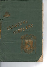
Large Book, BEAUTIFUL SCOTLAND
Signed & dated 1916.Prefaced"a few examples of some of the famous,the beautiful,and the historicplaces for which this delightful land is so justly renowned.....The craftmanship in producing such a record of that time.Historic & Artistic significance.Surely rare therefore highly significant.LARGE "Portrait"slender book of views of SCOTLAND .Cover green cardboard pages aged cream .Gold embossing to front cover .Front Cover....Gold embossed title Beautiful Scotland ...COAT of ARMS DEPICTING LION RAMPENT ,ACROWN ,,ATARTAN&SCOTCH THISTLES.ALSO A CROWN ON ACUSHIONWITH A SCEPTRE . -
 Greensborough Historical Society
Letter - Poem, June Roberts, Poem by June Roberts, 1960c
Freeform poem protesting loss of amenity of river frontage land in Greensborough, for inclusion in Greenhills Progress Association newsletter, by June Roberts1 p. typed letter, by June M. Robertspoulter reserve greensborough, pope place greensborough, june roberts -
 Greensborough Historical Society
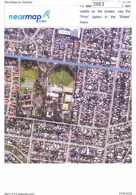
Photograph, Nearmap.com, Nearmap: Greensborough, 27/09/2012
Aerial photographs of the Watsonia area, land owned by Black and Families, including sites of Loyola College, Loyola Reserve and Gresswell ReserveFour coloured aerial photographswatsonia, black family, loyola college, gresswell forest reserve -
 Greensborough Historical Society
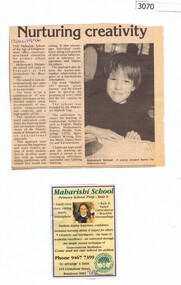
Newspaper clipping, Diamond Valley Leader, Nurturing creativity, 17/12/1996
The Maharishi School was due to open in Bundoora in February 1997. This school was on the Loyola College site before Loyola acquired the building and land.Promotional article with photograph (17 December 1996), and advertisement (10 December 1996)transcendental meditation, maharishi school bundoora, loyola college -
 Halls Gap & Grampians Historical Society
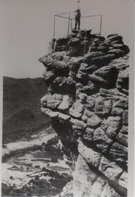
Photograph - B/W
The Pinnacle Lookout with Fyans Valley below. Bellfield Hotel is visible in the lower left of the picture, cleared land is apparent in the middle of the picture.Man standing at a lookout on a rocky outcrop overlooking a valley. Guide rails surround part of the outcop. A mountain range is opposite.scenery, lookouts -
 Eltham District Historical Society Inc
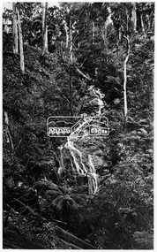
Photograph, Kinglake National Park, Wrights Falls
The Wright family owned the land on which the Falls were situated and were sold for a penny an acre according to a Wright family story. This photo forms part of a collection of photographs gathered by the Shire of Eltham for their centenary project book,"Pioneers and Painters: 100 years of the Shire of Eltham" by Alan Marshall (1971). The collection of over 500 images is held in partnership between Eltham District Historical Society and Yarra Plenty Regional Library (Eltham Library) and is now formally known as 'The Shire of Eltham Pioneers Photograph Collection.' It is significant in being the first community sourced collection representing the places and people of the Shire's first one hundred years.Digital imagesepp, shire of eltham pioneers photograph collection, kinglake, kinglake national park, wrights falls -
 Federation University Historical Collection
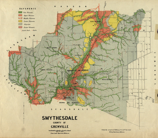
Map, Smythesdale, County of Grenville, 1888, 1889
The map maker, Ferdinand M. Krause, was a professor at the Ballarat School of Mines. This land was printed form the Crown Lands Department, Melbourne. Coloured map of the County of Grenville. The edge has been taped. The scale is 40 chains to 1 inch. The map is accompanied with a foolscap sheet printed by the Mines Department in 1898. It is a Report on the Parish of Smythesdale by F.M. Krause and includes information on the water reserve, worked quartz veins, Watson's Hill, Surface Hill and Sugarloaf Hill, Haddon, Trunk Lead and the Crucible Shaft. smythesdale, krause, f.m. krause, ferdinand krause, nitingbool, watson's hill, surface hill, sugarloaf hill, haddon -
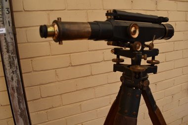 Tatura Irrigation & Wartime Camps Museum
Dumpy Level, Dumpty Level, 1920
Used by Mr. Craven to survey agricultural land in the Goulburn Valley for the purposes of setting out farm irrigation channels and check banksStanlley Dumpy Level on tripod, complete with carrying case and sixteen foot telescopic staffPatent Stanlley, Great Turnside, Holborn, London 11182surveying, irrigation, terrestrial -
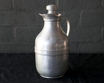 Robin Boyd Foundation
Functional object - Appliance
The Boyd family recall that Robin Boyd always took a thermos filled with tea on drives to look at land, houses or new cars.Thermos/jug with cork stopper, aluminium body and stopper handleThermos/jug with cork stopper, aluminium body and stopper handlecookware, walsh st kitchenware, robin boyd -
Stawell Historical Society Inc
Book - Report, The Remnant Vegetation of the Shire of Stawell, 1990
Study of what remains of Native Vegetation towards conserving what remains on Public and Private land as well as revegetation through shireBound PaperThe Remnant Vegetation of the Shire of Stawell by John Miller. School of Biological and Chemical Sciences Ballarat University Collage -
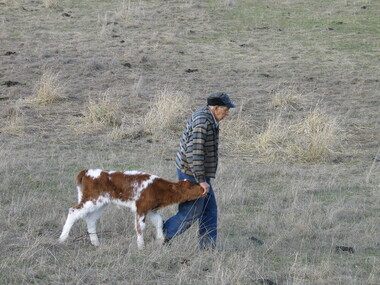 Ballarat Heritage Services
Photograph - Digital Photographs, Vince Gervasont at his Yandoit Creek Farm, 2004, 2004
Vince Gervasoni was the Great Grandson of Luigi Gervasoni of San Gallo, Bergamo, Italy. Luigi selected land at Yandoit Creek in the 1860s,Colour photograpsh of Vince Gervasoni on his farm at Yandoit Creek, Victoria.farm, farming, vealer, livestock, yandoit, yandoit creek, vince, gervasoni, vince gervasoni, agriculture -
 City of Kingston
Pamphlet - Colour, H. R. Hill & Co, Walker's Estate, Cheltenham for sale by public auction, c. 1923
Sales plan for land in the suburb of Cheltenham, encompassing both sides of Walker Grove, a section of Centre Dandenong Rd and Axelton St. The developing urban area of Cheltenham within the City of Kingston. This land sale pamphlet illustrates the subdivision of land within the municipality and the changing demographic of the district as new houses are constructed.Black and white pamphlet advertising for private sale the Station Entrance Estate, Highett. Incorporates a map of the estate bordered by Wickham Road, Railway Parade, Highett Road and Point Nepean Road.Handwritten in black pen on subdivision map: 'x' written on subdivisions 2, 3, 8-11, 15-17, 19. Potentially indicating that these properties did not sell at auction. Handwritten in black pen on subdivision map: assumed sale price on subdivisions 1, 4-7, 12-14, 18, 20-31. land sales, cheltenham, estate -
 City of Kingston
Pamphlet - Colour, Roy Dunn Pty. Ltd, Subdivisional auction of Highett Station Estate, c.1924
Sales plan for land in the suburb of Highett, bounded by Worthing Road, and the Melbourne to Frankston Electric Railway Line, including LePage Street. The developing urban area of Highett within the City of Kingston. This land sale pamphlet illustrates the subdivision of land within the municipality and the changing demographic of the district as new houses are constructed close to infrastructure.Colour pamphlet advertising a subdivisional auction of the Highett Station Estate. Incorporates a map of the estate bordered by Worthing Road and the Melbourne to Frankston Electric Railway, and including LePage Street. Handwritten in black ink on front cover: Late LePage / Wickham Rdland sales, estate, highett -
 City of Kingston
Pamphlet - Colour, Smith, Nicolson Pty. Ltd, Cheltenham Estate, c. 1890
Sales plan for land in the suburb of Cheltenham, bounded by Point Nepean Road and Swinden Avenue, including Evesham Road and Wallingford Street.The developing urban area of Cheltenham within the City of Kingston. This land sale pamphlet illustrates the subdivision of land within the municipality and the changing demographic of the district as new houses are constructed close to infrastructure.Colour pamphlet advertising for private sale Cheltenham Estate. Incorporates a map of the estate bordered by Point Nepean Road and Swinden Avenue, including Evesham Road, and Wallingford Street.Handwritten in red ink on subdivison 45: D / H Handwritten in red ink on subdivision 46: Anderson Handwritten in red ink on subdivisions 88, 87, 77 and 56: K / D Handwritten in red ink on subdivision 86: D / H Handwritten in red ink on subdivision 63 and 62: Hudson Handwritten in red ink on subdivision 59 [indecipherable] Handwritten in red ink on subdivision 58: aB Handwritten in red ink on subdivision 57: Lavosh Handwritten in grey pencil on subdivision 28, 26, 24, 67, 58, 49: B Handwritten in grey pencil on subdivisions 78 and 79: Paint Handwritten in purple pencil on subdivsion 114 and 86: B land sales, estate, cheltenham -
Clunes Museum
Book, DESIGNED BY PETER BUCKMASTER, WOOL PAST THE WINNING POST: A HISTORY OF THE CHIRNSIDE FAMILY, 1978
A BIOGRAPHY WRITTEN BY HEATHER B. RONALD OF THE HISTORY OF THE CHIRNSIDE FAMILY SOME OF WHO SETTLED ON LAND NEAR CLUNES, VICTORIA A SUMMARY OF THE CHIRNSIDE FAMILY'S MOVE TO THE AUSTRALIAN COLONIES AND THEIR CONTRIBUTION TO THE WOOL INDUSTRY IN THE 1800'S AND ONWARDSHARDCOVER BOOK BOUND IN BLUE LFABRIC WITH A GOLD EAGLE EMBOSSED ON THE FRONT COVER, COMPLET WITH DUST COVER. THE DUSTCOVER FRONT COVER HAS A COLOUR IMAGE OF A COLONIAL HOMESTEAD IN THE BACK GROUND WITH A LOADED DRAY PULLED BY OXEN TWO FIGURES WITH BULL WHIPS AT EITHER SIDE OF THE THE ANIMALS 203 PAGESnon-fictionA BIOGRAPHY WRITTEN BY HEATHER B. RONALD OF THE HISTORY OF THE CHIRNSIDE FAMILY SOME OF WHO SETTLED ON LAND NEAR CLUNES, VICTORIA A SUMMARY OF THE CHIRNSIDE FAMILY'S MOVE TO THE AUSTRALIAN COLONIES AND THEIR CONTRIBUTION TO THE WOOL INDUSTRY IN THE 1800'S AND ONWARDS book, chirnside family, clunes first sheep run -
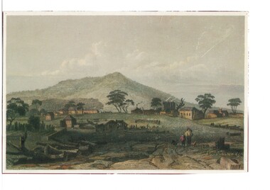 Buninyong & District Historical Society
Artwork, other - Colour reproduction of lithograph "Township of Buninyong" c1852, "Township of Buninyong" c1852
Early image of Buninyong c1852 showing evidence of land clearing, cultivation, residential and farm buildings and Mount Buninyong with tree coverBuninyong was one of the earliest settlements Victoria and became a very important place in the history of the goldrushColour reproduction of lithograph "Township of Buninyong" c1852 from the cover of "Three Times Blest"Henry Winkles Township of Buninyong c 1852 Lithograph, originally published in Montgomery Martin's "Australia" Reproduced "Three Times Blest"early settlement, henry winkles, mount buninyong, buninyong -
 Ringwood and District Historical Society
Document - Research Folder, Helm Family, Oban Road, Ringwood, Victoria - 1917-2008
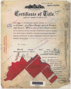
Transcription of conversation with Alma and Kelly Helm by Richard Carter (Past President of Ringwood Historical Society) and Larraine Haslam on 18 July 2008 detailing family history. Certificates of title of land between Oban Road and Mullum Mullum Creek. Six and a half acres sold to the Helm Family in 1917. Includes Certificate of Title Vol 5311 Fol 1062052 Carolyn Mary Glynn dated 27 April 1927. Certificate of Title Vol 4023 Fol 804560 Robert Beckett dated 19th January 1917. Plans of Subdivision including Oban Road, Barnsdale Way, Loughies Track, 1997. Certificate of Title Vol 4029 Fol 805702 Ellen Elizabeth Helm dated 8th February 1917. Transfer of Land (2093031) payment to James William Dartnell by Alma Mary Helm and Elsie May Helm of Oban Road, Ringwood North - 13th August, 1947. -
 City of Moorabbin Historical Society (Operating the Box Cottage Museum)
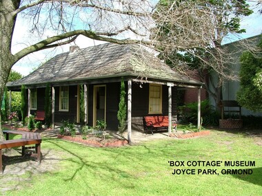
Photograph - ' Box Cottage' Reconstruction, c1841
The original small, pioneer cottage was built in the late 1840s to early1850s, by an unknown pioneer. It was located on part of a 30 Acre allotment that was originally part of Henry Dendy’s Special Survey granted in 1841. The doors and window sashes, (made of red deal joinery timber), as well as the brass locks and fittings, are from the original cottage, and were imported from England.The fire-place bricks are from the original cottage, and are sun-dried, (not kiln fired), and are hand-made. Convict marks can be seen on two bricks.There is a small display of external cladding shingles from the original pioneer cottage. These shingles were hand-split, and most likely made from locally collected timber The nails included in this display were used to fasten the shingles on the original cottage, and are also hand-made. The enamel nameplate, “Colonial”, on the wall of the cottage, was the name chosen for the original pioneer cottage when a later owner, Mr August Rietman and wife Frieda leased the property in around 1917. August purchased the property 1935 for 1200 Pounds approximately and resided there until 1953. In 1974 Mr Lewis, a timber specialist, found the dilapidated building on property he had recently purchased in Jasper Rd and suggested it be reconstructed and relocated. Moorabbin Council agreed and the Cottage was rebuilt just about 250 metres from its original site. The cost of the rebuild was met by 'Victoria's 150th Committee, plus a small grant from the City of Moorabbin, and Mr Laurie Lewis donated much of the timber for the reconstruction. Although 'Box Cottage' is a re-construction, it is an unique museum that, being located in the midst of a modern community in Ormond Victoria, can educate and demonstrate many aspects of the early settler’s way of life in Victoria. As such, it is an invaluable resource for students and all kinds of visitors. The original small, pioneer cottage was built in the late 1840s to1850s, by an unknown pioneer. It was located on part of a 30 Acre allotment that was originally part of Dendy’s Special Survey granted in 1841. The re-constructed pioneer cottage, named ‘Box Cottage’, is located only a matter of metres from the original pioneer cottage site, in Joyce Park, Jasper Road, Ormond, Victoria. The museum has copies of interesting Land Titles associated with the surrounding land, including the site of the original pioneer cottage, from Dendy’s time, and into the 1900s. ‘Box Cottage’ is named after the pioneers, William and Elizabeth Box, who resided in the original cottage from approximately 1865, until Elizabeth’s death in 1914.The re-constructed cottage plan has followed faithfully the original dimensions, and plan of the original pioneer cottage, and as many original items from that cottage’s long occupation have been incorporated. Convict marks on sun -dried, fire-place chimney bricks. Enamel nameplate 'Colonial' circa1915brighton, moorabbin, cottages, pioneers, ormond, colonial, mckinnon, dendy henry, box william, box elizabeth, convicts, rietman august, rietman frieda, rietman stefanie