Showing 31219 items
matching building a
-
 Bendigo Historical Society Inc.
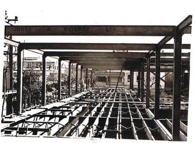
Photograph - S.E.C. VICTORIA, 1940
Photograph - black and white. The new SEC building under construction, steel girders and framework being erected. 'Johns and Waywood Ltd' is the name painted on the streel girders. Building in the middle background of photo has the sign 'Royal Mail Hotel' - Beer. Building in the left side background of picture has the word 'Myer', Markings on rear of photo read ''1st floor SEC 1940''organization, public utility, electricity company, s.e.c. victoria. 1940. bendigo. -
 Federation University Historical Collection
Invitation, Invitation to the Opening of the Ballarat School of Mines Museum, 1982, 03/1982
Federation University Australia was established on 1 January 2014. Formerly known as the University of Ballarat, its enabling legislation was the University of Ballarat Amendment (Federation University Australia) Act 2013. Although formally created as a University in 1994, the University of Ballarat has a lineage back to 1870 with the establishment of the School of Mines Ballarat, making it the third institution of higher learning to be established in Australia and the first to be established in regional Australia. On 1 January 1994, Ballarat University College became the University of Ballarat and in 1998 the University merged with three TAFE Institutes to become a dual sector institution with multiple campuses. On 1 January 2014, the University of Ballarat amalgamated with the Monash University Gippsland Campus to form Federation University Australia. The Gippsland Campus also had a long lineage dating back to 1928 with the establishment of the Yallourn Technical School which became a predecessor institution to the Gippsland College of Advanced Education formed in 1968. In 1990, it was renamed the Monash University College and in 1993 became the Gippsland Campus of Monash University. In 2016, Federation University Australia announced plans to take possession, over a two-year period, of Monash’s Berwick Campus in the south-east corridor of Melbourne. Federation University Australia, or FedUni, is headquartered in Ballarat and offers programs in Higher Education and Vocational Education and Training to regional Victoria and beyond. The University’s commitment to educational and social equity, teaching excellence, research distinction, environmental sustainability and regional capacity building has enabled it to develop in a way that draws on its proud heritage to inform its future. Its regional character sets a framework for the University’s priorities but does not constrain it from serving wider community interests, nationally and internationally. The name Federation University Australia was chosen to convey the scope and capacity of an expanded regional university with a federated network of campuses.Cream folded card invitation with an image of the Former Ballarat Circuit Court on the front. This building was used as the first Ballarat School of Mines when it first opened in 1870.ballarat school of mines, ballarat school of mines museum, g.h. beanland, museum reopening -
 Bendigo Historical Society Inc.
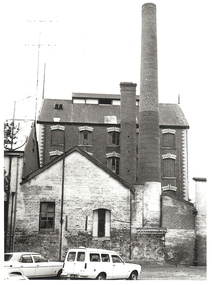
Photograph - FRIEDRICH AND BASSEMEIR VIENNA BAKERY: BENDIGO, 1960's ?
black and white photograph. Brick building, 3 or 4 storey, 2 chimneys, 1 square, 1 round. Lower brick building at front partially painted with 1 window and 1 double door. The door set into partially filled in brick arch. Main building has decorative brick work above windows and at corners of building. 2 vehicles in foreground, 1 sedan, 1 panel van. Corrugated iron roof, finial at each end above gable. Ball point pen on back 'Friedrich and Bassemeir Bakery, FSP/1204.organization, business, friedrich and bassemeir bakery -
 Charlton Golden Grains Museum Inc
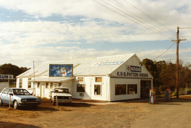
Patton's Garage West Charlton c. 1987
The garage was established in the 1930s by Mr Gamble. Other proprietors were Perc Kimberley 1943-46, Henderson 1946, Neil Rogers. K. & B. Patton ran the garage from 1960s - 2008Colour photo of K. & B. Patton's Garage. The garage is a white, weatherboard single story building with a corrugated iron roof. There small lean-to on the LH side of the building. There is a large entrance and two large windows on the front. There are two petrol pumps at the front of the building. A blue car and a white utility are parked at the LH side of the garage. The signage on the front of the building reads K. & B. PATTON NISSAN and there is a NISSAN sign painted on the roof. There is a sign for Peter Stuyvesant cigarettes on the roof of the lean-to. A telegraph pole and the entrance to Gordon Park is on the right of the photo.perc kimberley, k & b patton, gamble, henderson, neil rogers -
 NMIT (Northern Melbourne Institute of TAFE)
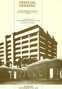
Photograhps: Building and Official opening of Otter Street Campus, 1981, Photographs: Building and Official opening of Otter Street Campus, 1981
Three Photograph albums of the Otter Street building of Collingwood Technical College. One consists of photographs of the progressive building and the second consists of photographs of the Official Opening of the Otter Street Campus on Thursday September 17th 1981 at 2pm by His Excellency The Honourable Sir Henry Winneke, Governor of Victoria. Also an Invitation card to the event. Guests included Hon.AJ Hunt, Minister for Education. During the opening there was a bomb scare so the building was evacuated, hence the police presence. (Scott p.85). The third photo album is of students at Otter Street in building and horticulture classes. collingwood technical college, otter street campus, nmit -
 Bendigo Historical Society Inc.
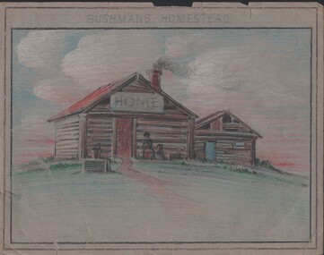
Painting - NORMAN PENROSE COLLECTION: BUSHMAN'S HOMESTEAD
Artwork. Norman Penrose collection: (1) Coloured pencil drawing of a homestead on a hill. Two people in front of the house. In front of the house is a bucket sitting on a box or a well. The house has another building beside it. They both look like log construction. Drawn on grey paper. (2) Tan drawing on light blue paper with a two story building in the background. A man on a ladder is working at the window. Two people are at the other window. There is a tall tree beside the building. In front of the building is a motor car. Three people are having a picnic on the grass beside the car.drawing, pencil, bushmans homestead, norman penrose collection, bushman's homestead -
 Bendigo Military Museum
Postcard - POSTCARD, FARNHAM, U.K, Valentine's Series, cWW1
1. Florrie is a relative living in Farnham. 2. R.H. Baron married Elsie Keast in 1921. All cards relate to R.H. Baron's visits to Farnham whilst on leave to see Florrie. Part of the 'Robert H. Baron', no.3596 and Cooper Collection. See Catalogue No. 1981P for details of Baron's service.1. Coloured scene of a ruined castle and surrounding gardens. 2. Coloured scene of a garden with building and ruins in background. 3. Coloured photograph of a red brick building with battlement. 4. Coloured street scene with buildings, horse drawn transport and pedestrians. 5. Coloured photograph of the nave of a church looking towards the alter. 6. Coloured street scene with buildings and horse drawn transport. 7. Coloured view across a street to a white walled building with horse drawn transport. 8. Coloured photograph of a church, graveyard in foreground. 9. Black and white photograph of a castle surrounded by trees. 10. Black and white photograph of a forest scene with people standing on a bridge. 11. Black and white photograph of a street scene with buildings, horse drawn transport and people. 12. Black and white photograph of the tower of a church. Graveyard in the foreground. 13. Black and white photograph of a street scene with buildings, horse drawn transport and pedestrians. Castle on the hill in background. 14. Black and white photograph of a street scene with buildings, motor cars and pedestrians. 15. Black and white photograph of a street scene with buildings, motor cars, horse drawn transport and pedestrians. 16. Black and white photograph of a wooded valley. Houses on a hill in the background. 17. Black and white photograph of an avenue of trees. 18. Black and white photograph taken in a park. Three people standing on a bridge over a stream.1. The Keep, Farnham Castle. Handwritten in black ink on back: 'This is one of the pretty places around Farnham. I was all once here with Florrie. Bob' 2. In Castle grounds, Farnham. Handwritten in black ink on back: 'Dear Elsie, these are some places that visit... when I was down at Flories place. Bob xxxxxx' 3. Farnham Castle. 4. West Street, Farnham. 5. Parish Church, Farnham. 6. Castle Street, Farnham. 7. The Church House, Farnham. 8. Parish Church, Farnham. 9. Farnham Castle. 10. Red Hill Hanger, Farnham. Handwritten in black ink on back: 'Letter to R.H. Baron's sister - no date.' 11. South Street, Farnham. Handwritten in black ink on back: 'this part of the place I spent my leave at this is where Florrie is.' 12. Farnham Parish Church. Handwritten in black ink on back: 'Letter to R.H. Baron's mother - dated 24 July 1918.' 13. Castle Street, Farnham. Handwritten in black ink on back. 'I think you will know where this is as I have told you quite a lot about Farnham, it is where Florrie is. I spent my leave here. This is Castle Street and the castle is right on the top of the hill.' 14. Borough, Farnham. Handwritten in black ink on back. ' This is the place where Florrie lives. I spent my last leave their (sic), Bob.' 15. West Street, Farnham. Handwritten in pencil on back. 'Pte R.H. Baron, 57 Battalion, Australian Imperial Forces Abroad.' 16. Lower Bourne Valley, Farnham. Handwritten in black ink on back: 'Partial letter from R.H. Baron to his sweetheart.' 17. The Avenue, Farnham. Handwritten in black ink on back: 'Partial letter from R.H. Baron to his mother.' 18. Recreation Ground, Farnham. Handwritten in black ink on back: 'Letter to Doris from R.H. Baron - no date.' robert h. baron, cooper collection, postcards, farnham uk -
 Kew Historical Society Inc
Plan, Melbourne & Metropolitan Board of Works : Borough of Kew : Detail Plan No.1578, 1904
The Melbourne and Metropolitan Board of Works (MMBW) plans were produced from the 1890s to the 1950s. They were crucial to the design and development of Melbourne's sewerage and drainage system. The plans, at a scale of 40 feet to 1 inch (1:480), provide a detailed historical record of Melbourne streetscapes and environmental features. Each plan covers one or two street blocks (roughly six streets), showing details of buildings, including garden layouts and ownership boundaries, and features such as laneways, drains, bridges, parks, municipal boundaries and other prominent landmarks as they existed at the time each plan was produced. (Source: State Library of Victoria). This plan forms part of a large group of MMBW plans and maps that was donated to the Society by the Mr Poulter, City Engineer of the City of Kew in 1989. Within this collection, thirty-five hand-coloured plans, backed with linen, are of statewide significance as they include annotations that provide details of construction materials used in buildings in the first decade of the 20th century as well as additional information about land ownership and usage. The copies in the Public Record Office Victoria and the State Library of Victoria are monochrome versions which do not denote building materials so that the maps in this collection are invaluable and unique tools for researchers and heritage consultants. A number of the plans are not held in the collection of the State Library of Victoria so they have the additional attribute of rarity.Original survey plan, issued by the MMBW to a contractor with responsibility for constructing sewers in the area identified on the plan within the Borough of Kew. The plan was at some stage hand-coloured, possibly by the contractor, but more likely by officers working in the Engineering Department of the Borough and later Town, then City of Kew. The hand-coloured sections of buildings on the plan were used to denote masonry or brick constructions (pink), weatherboard constructions (yellow), and public buildings (grey). MMBW Plan No.1578 is significant in that it defines the extent of two private schools: Xavier College and Kew High School (now part of Trinity Grammar) by 1904. In relation to the latter, the plan clarifies which buildings the High School operated from behind the mansion ‘Molina’. Established in 1902, Trinity Grammar was to later lease and subsequently buy Molina (now ‘Merritt House’) and ‘Elsinore’ (now ‘Roberts House’). Xavier College had been established in 1872. This 1904 plan delineates the West Wing and the Great Hall (built in 1890).melbourne and metropolitan board of works, detail plans, maps - borough of kew, mmbw 1578, cartography -
 Kew Historical Society Inc
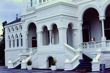
Slide - 'Burke Hall', Nolan Avenue, 1976
Colour transparency (slide) created in June 1976 during a tour by the Junior National Trust, which was led by members of Kew Historical Society. The collection of 21 slides reveals that the tour covered all parts of Kew, but focused understandably on heritage buildings and sites.Image of an historic place in Kew that can be dated to an exact time and place. The images, albeit amateurish in composition, frequently reveal aspects of important buildings and sites that have changed over time.35mm colour transparency of the front portico of Burke Hall (formerly Studley Hall, Waverley) and now Xavier Junior School in Nolan Avenue, Kew. Since its construction in the 19th century, the building has had numerous additions made by subsequent owners. The original render has been painted and sections of the original colonnades glazed in. The facade of Burke Hall faces away from Studley Park Road to take advantage of the views to the south.historic houses -- kew (vic), xavier college -- kew (vic.), burke hall -- kew (vic.), waverley -- kew (vic.), nolan avenue -- kew (vic.), studley hall -- kew (vic.) -
 Kew Historical Society Inc
Plan, Melbourne & Metropolitan Board of Works : Borough of Kew : Detail Plan No.1571, 1904
The Melbourne and Metropolitan Board of Works (MMBW) plans were produced from the 1890s to the 1950s. They were crucial to the design and development of Melbourne's sewerage and drainage system. The plans, at a scale of 40 feet to 1 inch (1:480), provide a detailed historical record of Melbourne streetscapes and environmental features. Each plan covers one or two street blocks (roughly six streets), showing details of buildings, including garden layouts and ownership boundaries, and features such as laneways, drains, bridges, parks, municipal boundaries and other prominent landmarks as they existed at the time each plan was produced. (Source: State Library of Victoria)This plan forms part of a large group of MMBW plans and maps that was donated to the Society by the Mr Poulter, City Engineer of the City of Kew in 1989. Within this collection, thirty-five hand-coloured plans, backed with linen, are of statewide significance as they include annotations that provide details of construction materials used in buildings in the first decade of the 20th century as well as additional information about land ownership and usage. The copies in the Public Record Office Victoria and the State Library of Victoria are monochrome versions which do not denote building materials so that the maps in this collection are invaluable and unique tools for researchers and heritage consultants. A number of the plans are not held in the collection of the State Library of Victoria so they have the additional attribute of rarity.Digital copy of the original survey plan, issued by the MMBW to a contractor with responsibility for constructing sewers in the area identified on the plan within the Borough of Kew. The plan was at some stage hand-coloured, possibly by the contractor, but more likely by officers working in the Engineering Department of the Borough and later Town, then City of Kew. The hand-coloured sections of buildings on the plan were used to denote masonry or brick constructions (pink), weatherboard constructions (yellow), and public buildings (grey). This plan is part of a large and historically significant group of MMBW plans and maps that was donated to the Society by the Mr Poulter, City Engineer of the City of Kew in 1989. When the contracts were let for surveyors to identify and record the extant houses and landscapes within an area for the Board of Works, the contracts were let at separate times, hence the anomaly where two copies of Plan No.1571 exist in our collection. The first of these plans identifies the building materials used in houses bordering Fitzwilliam Street, Edgevale Road, May Street, Malin Street, Davis Street and Wellington Street. The cut off point for the survey was the south side of Wellington Street. By 1903 when the survey was undertaken many of the sites were already built on, particularly those facing Edgevale Road. The plan identifies the preponderance of weatherboard houses in the area. The other version of the plan identifies the buildings between Wellington Street and Cotham Road.melbourne and metropolitan board of works, detail plans, mmbw 1571, cartography -
 Orbost & District Historical Society
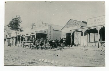
black and white photograph, August 1897
This photograph shows Nicholson Street, Orbost with horse teams in front Of Borland's Blacksmith shop and Royce's Bakery net door in August 1897.This is a pictorial record of the main street of Orbost in the late 19th century.A black / white photograph of the main street of Orbost. The road is unsealed. There are several wooden buildings facing the road and a cart with a team of horses is standing outside the blacksmith's building. A small child is standing behind the cart and several men are outside the bakery.on front - Orbostnicholson-street-orbost orbost-township borlands-blacksmith royces-bakery main-street-orbost -
Glenelg Shire Council Cultural Collection
Pamphlet - Pamphlet - Tourist Guide to Portland, n.d
Twelve page tourist guide to Portland, includes map of Portland on middle pages, showing location of historic buildings, tourist office. Guide contains list of historic buildings, suggested tours, picnic areas, advertising. White with black print. -
 Federation University Historical Collection
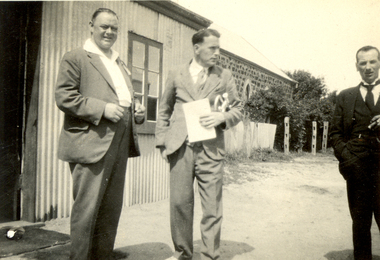
Photograph - Black and White, Members of the Ballarat Soldiers' Memorial Band at Tanunda, South Australia, 1930, Oct 1930
Frank Wright was a renown resident of Smeaton, where he was born. He lived at Laura Villa, and attended Smeaton State School. His father William was a gold miner and his mother's name was Sarah. Their family won many singing and instrumental awards. Frank was tutored by Percy Code and was awarded a gold medal for the highest marks in the ALCM examinations in the British Colonies at the age of seventeen years. He became the Australian Open Cornet Champion by the age of eighteen. A year later, Frank conducted the City of Ballarat Band, and later the Ballarat Soldiers’ Memorial Band. He formed the Frank Wright Frisco Band and Frank Wright and his Coliseum Orchestra. These bands won many South Street awards, and Frank as conductor won many awards in the Australian Band Championship contest. In 1933 Frank Wright sailed to England to conduct the famous St Hilda’s Band and was later appointed Musical Director of the London County Council, where he organized many amazing concerts in parks, in and around the London district. He was made Professor of Brass and Military Band Scoring and conducted at the Guildhall of Music and Drama. Frank was often invited to adjudicate Brass Band Championships around Europe, in Australia, including South Street and in New Zealand. The Frank Wright Medal at the Royal South Street competition is awarded to an individual recognized as making an outstanding contribution to brass music in Australia.Black and white photograph of three men dressed in suits, standing beside a corrugated iron building with a large stone building (perhaps a hall) in the background. The man on the left is Albert Jones and the man in the middle carrying a score and cornet is Frank Wright.Written in pencil on back - W.O. Albert Jones drum major, Frank Wright (Conductor), Ballarat S. M Band, Tanunda S.A., Oct 1930frank wright, conductor, cornet, albert jones, tanunda -
 Federation University Historical Collection
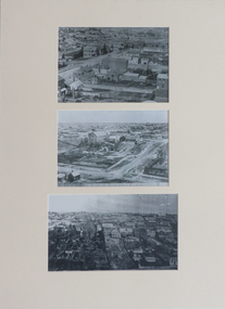
Photographs, Three Reproductions of Early SMB buildings, 01) - .2) 1872 .3) 1948
Three mounted black and white reproduction photographs depicting early SMB buildings .1) View of Ballarat Gaol, Old Court House and Wesley Church .2) Lydiard St South .3) SMB buildings 75 years laterblack and white photography, smb campus, lydiard street south, ballarat old court house, former wesleyan church, ballarat school of mines, dana street hill -
Port Melbourne Historical & Preservation Society
Document - Agreement, Erect Emersol Plant at Ingles Street, Port Melbourne, J Kitchen & Sons Pty Ltd and H G White Pty Ltd, 1 Sep 1949
Pale green agreement between messrs J KItchen & Sons Pty Ltd & messrs H G White Pty Ltd to erect a new Emersol Plant Building at Ingles St, Port Melbourne. Schedule of conditions of building contract.No. 25944industry, manufacturing, built environment - industrial, j kitchen & sons pty ltd, h g white pty ltd, emersol, f oakley, c e serpell, c r hansen, louis thompson, charles henderson, alder & lacey, ingles street -
 Bendigo Historical Society Inc.
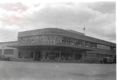
Photograph - S.E.C. VICTORIA, 1954
Black and White Photo of the S.E.C. Victoria Building, Decorated for the Royal Visit in March 1954, Opening of the S.E.C. Building in 1941. Car parked to left in photo, and another angle parked to right of photo. Flag on roof flying a half mast.organization, public utility, electricity company, s.e.c. victoria, sec victoria -
 Clunes Museum
Photograph
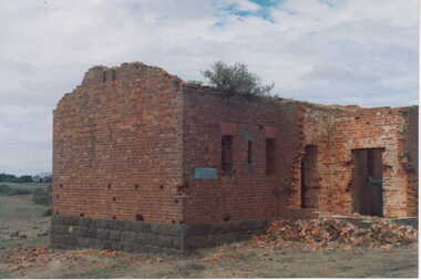
COLOURED PHOTOGRAPH BRICK BUILDING WITH BLUESTONE FOUNDATIONS-IN STATE OF DISREPAIR. ROOF DOORS & WINDOWS MISSING, SMALL PILE OF BRICK RUBBLE AT FRONT DOOR.--BUILDING COULD BE REMAINS OF POWDER MAGAZINE NEAR BIRCHES CREEK. BOXTHORN GROWING IN GUTTERING.local history, photography, photographs, mining, powder magazine -
 Lakes Entrance Regional Historical Society (operating as Lakes Entrance History Centre & Museum)
Photograph, 1890c
1 other photograph 10 x 16 archived.Black and white photograph showing view of entrance, dunes and Bullock Island, buildings and dunes at left, building and jetty and rock groynes on Bullock Island. Vessel near centre may be the Carpenter owned dredge the Wombat. Lakes Entrance Victoriafences, jetties, public works -
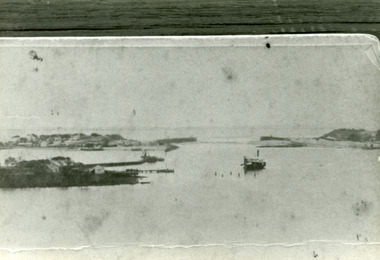
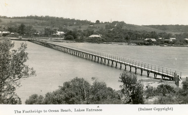 Lakes Entrance Regional Historical Society (operating as Lakes Entrance History Centre & Museum)
Postcard, 1937c
Copies as follows|One Miniture postcard tinted 6.5 x 9|One Black and white copy 6.5 x 11|One Tinted copy 20 x 28|One Postcard 17 x 12Black and white postcard showing waterfront, some buildings along esplanade, no buildings on Myer St Hill. Footbridge across Cunninghame Arm completed to high tide mark, ramp constructed later, scrub in foreground. Lakes Entrance VictoriaThe Footbridge to Ocean Beach Lakes Entrancevegetation, bridges, waterways, township -
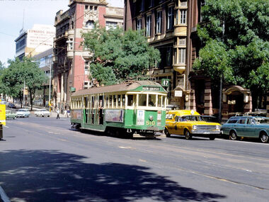
 Ballarat Tramway Museum
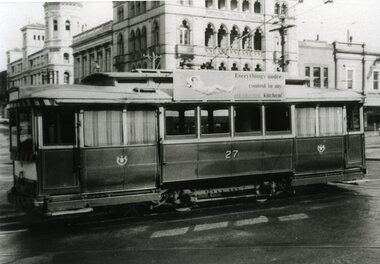
Photograph - Black & White Photograph/s, John Murray, Jun. 1969
Black and white photograph of Ballarat 27 departing the City Terminus, corner of Sturt and Lydiard Sts. Tram has the a SEC, a SEC roof advertisement. Craigs Hotel and National Mutual building buildings in the background. Photo by John Murray, c1969.On rear, written in black ink "SECV Ballarat No. 27 / c1969 / 18/23"tramways, trams, city terminus, sturt st, tram 27 -
University of Melbourne, Burnley Campus Archives
Plan, Alton-Hascombe Feature Survey, c. 1990
1 tracing paper and 2 paper copies, plan by Department of Conservation, Forests and Lands. Division of Survey and Mapping. Scale 1:1000. Plan of property includes buildings, gardens and paddocks. 1 copy has significant buildings coloured.alton-hascombe, survey -
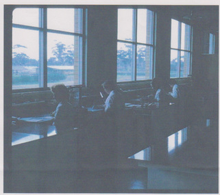 University of Melbourne, Burnley Campus Archives
Photograph - Colour prints, Gwen Vennell, Burnley Seed Testing Station, 2003
Seed Testing Station was operated by the Dept of Agriculture at Burnley but was not really used for teaching purposes 8 printed photographs from scans of slides of the Seed Testing Station. Views of the outside of the building and people working inside it. Taken by Gwen Vennell nee Easton soon after the building was opened and donated by her nephew Bruce Grant. seed testing station, gwen vennell ( easton), bruce grant -
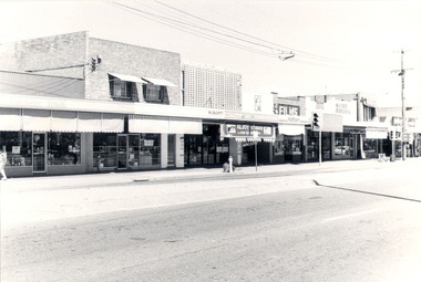 Wodonga & District Historical Society Inc
Photograph - Codling Collection 01 - High Street East - from Mahony’s to Finishing Touch, 1980s
Miss Olive Codling was a Foundation Member and a Life Member of the Wodonga Historical Society. Many of her prize-winning photos are held in the Society Collection. She also held a range of roles and committee positions in a wide range of Wodonga community organisations. These included the Horticultural Society, the Wodonga Arts Council, the Wodonga Camera Club and the Wodonga Lapidary Club. This photo collection is significant as it documents how the businesses and buildings in Wodonga have evolved and contributed to community throughout the 20th century.Eastern side of High Street, Wodonga - High Street East - from Mahony’s to Finishing Touch. Other businesses include Riah Hairdresser, W.J. Buckpitt Solicitors, Aljoy Studio, Hotham Building Society, Security Permanent Building Societywodonga businesses, high st wodonga, aljoy studio, w. j. buckpitt -
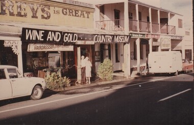 Rutherglen Historical Society
Image, January 1986
This shop, in Main Street Rutherglen, near Poachers Paradise pub (originally the Rutherglen Hotel), was owned and operated as a barber shop by Jack O'Keefe. This photograph was taken in 1986. The couple in front of the building are probably Jack O'Keeffe and his wife. At present (2019) part of this shop is again operating as a hairdressers, as Jack and the Fox.Colour photograph of the front of a shop with a banner below the veranda identifying it as the Wine and Gold Country Museum. The building is located in Main Street Rutherglen next to the Poachers' Paradise Hotel. Below the banner is a shop sign "Hairdresser & Tobacconist" and another "Tourist Information". A man and woman are standing in front of the shop watering the plants. Above the veranda is another sign indicating that some part of the shop was once used as a billiard parlor.Writen on the back of the photo: "January 1986"jack okeefe, barbers, hairdressers -
 Kew Historical Society Inc
Photograph - Royal Hotel, Sunbury, C.H.R. Christianson, 1890s
This item is part of a larger collection donated to the Kew Historical Society by Anna French. The collection includes personal items from the donor's family, as well as items given to the donor and her mother by a family friend, Lucy Merritt (Jean) Hornby. The item is from that part of the collection inherited or assembled by Jean Hornby. The collection is significant given Jean Hornby's mother's descent from Robert Hornby (1854-1935) and Eva Merritt (1865-1959); her mother the chid of a family who settled in Kew in the 1850s, this providing a chain of provenance for items dating to the mid-nineteenth century, when her maternal forebears arrived in Melbourne. Other items represent Jean Hornby's contribution to her local and wider community.This 19th century photograph includes significant architectural details of an important hotel in Sunbury, Victoria. Additionally, it was taken by a local photographer - CHR Christianson - who operated the Sunbury [photographic] Studio. Silver albumen print, mounted on board, of the original Royal Hotel on the corner of Brook and Evans Streets, Sunbury, Victoria.The single-storey, rendered brick building with a corrugated galvanised iron roof includes a number of pieces of information that may assist in dating the photograph. The licensee's name above the door appears to be M.A. Williams. To the left of the door on the external wall is a painted sign: 'BILLIARDS". Another painted sign on the front of the building reads "ROYAL HOTEL [illegible] BILLIARDS." An attached building at right may be the residence of the licensee. Specific architectural features of the building include a corner doorway with a lamp above, three sash windows and a larger square lead-light window to the right of the doorway. The latter identifies the space behind as the "BAR". On the footpath in front of this building is a grill set into the footpath to enable deliveries to a cellar. At least four figures can be identified in the photograph: a woman in the doorway, a man to her right, leaning against the wall, and two other men at the right hand side of the building. Beyond the boundary of the building is a sloping footpath to a bluestone edged gutter. An elm [sic] within a protective, picketed surround is in front of the building. C.H.R. Christianson is identified on the reverse as the photographer. Reverse in pencil: Royal Hotel Billards Sunbury / CHR Christianson photographerroyal hotel -- sunbury (vic.), chr christianson -- photographer, hotels -- sunbury (vic.), recreation -- billiards -
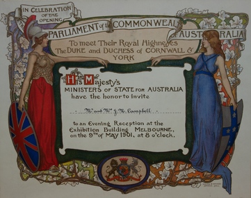 Kew Historical Society Inc
Document - Invitation To Meet their Royal Highnesses, the Duke and Duchess of Cornwall & York, Commonwealth of Australia, 1901
The commemorative booklet 'Our Invited Guests for the Opening of the First Parliament of the Commonwealth of Australia : An open directory of the guests invited to Melbourne, May 9th 1901' lists invitees from each Australian State. Mr & Mrs. J. M. Campbell are on this list, and recoded as residing at "Ramornie" 40 Pakington Street, Kew.The document design has artistic and aesthetic merit. While it is not rare, it is representative of the kinds of formal designs used for the Australian Commonwealth celebrations at the time of Federation, and is in excellent condition. Such items as this invitation have local, state and national historic significance as mementoes of a key moment in Australia's history. Locally, the invitation is part of a group of Federation-related items issued to James Maitland Campbell (and his wife). Campbell was three times mayor of Kew in the second half of the 19th Century and the owner of Ramornie in Pakington Street, one of the significant extant mansions in Kew.An invitation on card to Mr. & Mrs J. M. Campbell to attend an evening reception at the Exhibition Building, Melbourne, on 9 May 1901, to meet the Duke and Duchess of Cornwall as part of the celebrations of the opening of the first Federal Parliament. A figure of Britannia, in red dress and mailed vest holding a shield like the Union Jack, is on the left of the invitation; she reaches out her hand towards a younger female figure, representing Australia, who is dressed in blue and holds a shield which is white with a blue cross decorated with stars. The writing is on a scroll in the centre of the certificate, and there is a border of vines and vine leaves. The royal crest is at the base of the certificate.Printed on a banner across the top: 'IN CELEBRATION / OF THE / OPENING / PARLIAMENT of the COMMONWEALTH / OF AUSTRALIA' Printed below the banner: 'To meet Their Royal Highness / the DUKE and DUCHESS of CORNWALL & / YORK / His Majesty's / MINISTERS OF STATE FOR AUSTRALIA / have the honor to invite / [handwritten] Mr. & Mrs J. M. Campbell / to an Evening Reception at the / Exhibition Building MELBOURNE, / on the 9th of May 1901, at 8 o'clock'.federation -- australia -- 1901, parliament -- australia, invitations -- 1901 -
 Warrnambool and District Historical Society Inc.
Ledger, Letters on Suspension Bridges, 1890s
This book contains information on the building of suspension bridges and dates from the 1890s. It belonged to John William Crawley Junior, an engineer, surveyor and architect in private practice in Warrnambool and also the engineer for the Shire of Warrnambool from 1895 to 1935. The information in the book comes in the form of lectures on suspension bridge making and these were sent to John Crawley by his tutor or coach, Arnold Lilley (Lilly). Arnold Lilley was an Oxford mathematician working in Victoria and it is said that he coached or trained 95% of the municipal surveyors in Victoria in the 1890s. John Crawley has obviously had this material bound into a book and it was passed on to his son, Rolf, who was the engineer for the Shire of Warrnambool from 1935 to 1968. It then came into the possession of Michael Hand who took over the private surveying business of Rolf Crawley in Warrnambool. The Warrnambool and District Historical Society acquired the book, along with several Crawley ledgers and letter books, from the estate of Michael Hand. This book is of interest as it contains lectures and other material on the building of suspension bridges and belonged to John William Crawley Junior, an engineer for the Shire of Warrnambool for 40 years. It also is a memento of the work of Arnold Lilley who produced the material on suspension bridges and coached John Crawley in his surveying studies.This is a hard cover book with a purple cover. The cover is slightly faded. The book contains handwritten material regarding the building of suspension bridges and includes sketches, lectures on suspension bridges and pages with postage stamps on them. There are three loose pages. ‘’Letters on Suspension Bridges Arnold Lilly Esq. Coach J Wm. Crawley Pupil’john william crawley junior, warrnambool, rolf crawley, warrnambool, shire of warrnambool, arnold lilley, teacher of surveying. -
 Melbourne Tram Museum
Photograph - Digital Image, Dick Jones, W2 510 east bound in Collins St, Nov. 1967
Digital image of W2 510 east bound in Collins St, with the King St intersection in the background. Tram showing route 47, Kew Depot. In the background is a RACV station wagon, a policeman on point duty. The tram has adverts for Berec butter, Photo by Dick Jones - reference - 510_CollinSt_DickJones_6711M7.34.62 Buildings as advised by Rod Atkins 11/11/2019 William Angliss Building 528 - 534 Collins street - NE cnr. of King street - since demolished New Zealand Loan & Mercantile Company Ltd. building 538 – 544 Collins Street – NW cnr. of King street. McPhersons Building 546 – 555 Collins Street. Edwards Dunlop and Company Ltd. Building 568 – 580 Collins Street – since demolished.trams, tramways, w2 class, collins st, kew depot, route 47, tram 510 -
Federation University Historical Collection
Photograph, Former Wesley Church Ballarat Plaque, c1959
Colour photographOriginally the Wesley Church built in 1856. This building was purchased by the School of Mines in 1883, when it became the museum. In 1859 it was converted into the E.J. Tippett Recreation Hall.buildings, ballarat school of mines, smb campus, former wesley church, ballarat school of mines museum, e.j. tippett recreation hall -
 Ringwood and District Historical Society
Photograph, Building the old Ringwood baths in Ringwood St 1934
Black and white photograph. 2 copies- 1 large, 1 small.Typed below photograph, "Building the old Ringwood baths in Ringwood St. The car is in Ringwood St. and the bridge over the Mullum Creek can be seen. 1934".