Showing 10934 items
matching land
-
 Bendigo Historical Society Inc.
Document - H.A. & S.R. WILKINSON COLLECTION: CONTRACT OF SALE
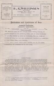
Contract of sale dated 3rd November, 1959 between Mrs. A. Hemley (seller) and Mr. G.F. * Mrs. P.E. Stacey (buyer). Solicitor for vendor and purchaser: H.E. Every, Dispensary Walk, Bendigo. Property at 44 Wood Street, Long Gully, being part of Crown allotment 4 section P described in certificate of title volume 8088 folio 607. Also that piece of land comprised in certificate of title volume 8202 folio 301 and that piece of land comprised in certificate of title volume 8202 folio 302. Together with all floor coverings, blinds, curtains, electric light fittings and shades. Price 3,700 pounds. Attached 2 copies of statement pursuant to section 34 of the estate agents act 1956 signed by H.A. Wilkinson and 1 copy of engagement or appointment in writing pursuant to section 33 of the estate agents act 1956 signed by the vendor.organization, business, h.a. & s.r wilkinson real estate -
 Bendigo Historical Society Inc.
Document - H. A. & S. R. WILKINSON COLLECTION: CONTACT OF SALE
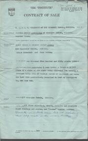
Contract of sale dated 31st March, 1958 between Mrs. C. M. Cunningham (vendor) and Mr. J. E. & Mrs. D. L. Preece (purchaser). Solicitor for vendor: E. S. Cahill & Son, View Street, Bendigo. Solicitor for purchaser: H. E. Every, Pall Mall, Bendigo. Property: 177 McIntyre Street, Bendigo land containing 1 rood having a frontage of 100 links by a depth of 250 links being allotment 116 section A Ironbark Gully City of Bendigo land described in deed of conveyance no. 942 book 642, together with all floor coverings, blinds, curtains and electric light fittings and shades and "Turner” washing machine. Price: 2,550 pounds. Attached Statement pursuant to section 14 of the estate agents act 1956, Engagement in writing pursuant to section 33 of the estate agents act 1956 and 2 hand written notes.organization, business, h.a. & s.r wilkinson real estate -
 Bendigo Historical Society Inc.
Document - H. A. & S. R. WILKINSON COLLECTION: CONTRACT OF SALE
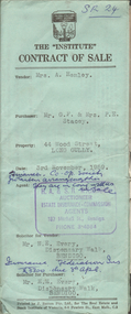
Conditions of sale by private contract dated 29th November, 1949 between E. G. S. Rasmussen (vendor) and E. Simmons (purchaser). Property: land situate Havlin Street, Bendigo at present occupied by the purchaser, being part of Crown allotments 392 and 393 section H, Parish of Sandhurst City of Bendigo, land described in certificate of title volume 5514 folio 1102695, together with 5 room weatherboard dwelling and all sundry outbuildings. Price 1,200 pounds. Attached 4 hand written notes plus 1 letter dated 29th November, 1949 and signed by Mr. Rasmussen detailing the payment to Mr. Simmons the sum of 300 pounds on 10th January, 1950 and a further 100 pounds on 25th February, 1950. Also a letter dated 29th November, 1949 signed by Mr. Simmons acknowledging receipt of the sum of 400 pounds being part of a loan.organization, business, h.a. & s.r wilkinson real estate -
 Kew Historical Society Inc
Photograph, J F C Farquhar, The Yarra in Hyde Park, 1891
At the beginning of the 1890s, the Kew businessman and Town Councillor, Henry Kellett, commissioned J.F.C. Farquhar to photograph scenes of Kew. These scenes included panoramas as well as pastoral scenes. The resulting set of twelve photographs was assembled in an album, Kew Where We Live, from which customers could select images for purchase.The preamble to the album describes that the photographs used the ‘argentic bromide’ process, now more commonly known as the gelatine silver process. This form of dry plate photography allowed for the negatives to be kept for weeks before processing, hence its value in landscape photography. The resulting images were considered to be finely grained and everlasting. Evidence of the success of Henry Kellett’s venture can be seen today, in that some of the photographs are held in national collections.It is believed that the Kew Historical Society’s copy of the Kellett album is unique and that the photographs in the book were the first copies taken from the original plates. It is the first and most important series of images produced about Kew. The individual images have proved essential in identifying buildings and places of heritage value in the district.Hyde Park is now a small recreation reserve bordered by Willsmere and Kilby Roads and White Avenue. In 1982, Hyde Park was cut off from the Yarra River by the construction of the Eastern Freeway. The building of the latter was to transform the natural landscape, including the Yarra, as well as Hyde Park. The construction of the Freeway makes it difficult to view the scene with the photographer’s eye. Today’s Hyde Park is located on land purchased in 1847 by John Cowell, and in 1851 Catherine Cowell, yet the scene selected by the photographer may well have been located on farmland owned by the Wills family. Farquhar’s point-of-view emphasises both the pastoral and recreational elements of the scene: the grazing cows, three boys, and in the distance two figures, seated on the bank with a parasol. By 1891, an environmental consequence of human activity, including farming, was deforestation, leading to the erosion of the south bank of the Yarra. In contrast, the land on the Alphington side of the river in 1891 included remnant bushland.The Yarra in Hyde Parkkew illustrated, kew where we live, photographic books, henry kellett, yarra river -
 Kew Historical Society Inc
Plan - Subdivision Plan, Camberwell Mountain View Estate, 1923
The Kew Historical Society collection includes almost 100 subdivision plans pertaining to suburbs of the City of Melbourne. Most of these are of Kew, Kew East or Studley Park, although a smaller number are plans of Camberwell, Deepdene, Balwyn and Hawthorn. It is believed that the majority of the plans were gifted to the Society by persons connected with the real estate firm - J. R. Mathers and McMillan, 136 Cotham Road, Kew. The Plans in the collection are rarely in pristine form, being working plans on which the agent would write notes and record lots sold and the prices of these. The subdivision plans are historically significant examples of the growth of urban Melbourne from the beginning of the 20th Century up until the 1980s. A number of the plans are double-sided and often include a photograph on the reverse. A number of the latter are by noted photographers such as J.E. Barnes.The so-called Camberwell Mountain View Estate was a subdivision on ‘the corner [of] Burke Road, Eyre and Wills Streets, Deepdene’. The Estate was not the first attempt to subdivide this land holding. In 1884, 1888 and 1894 the Belmore Park subdivision proposed 18 allotments for this parcel of land. The final stages of the Belmore Park subdivision occurred during the Depression of the 1890s. Apart from perhaps one block facing Burke Road, which is unnumbered in the Mountain View Estate subdivision, the rest must have remained unsold. The later subdivision would redraw the original 18 allotments, creating 22 new lots. In the Locality Plan on the left side of the subdivision plan, Deepdene Station, which formed part of the Outer Circle Railway is represented, as is the location of Deepdene Primary School. A selling point was the proposed extension of the Burke Road tram beyond its terminus at Cotham Road. The extension did not eventuate.subdivision plans - camberwell, mountain view estate -
 Royal District Nursing Service (now known as Bolton Clarke)
Photograph - Photograph, black and white, Barry Sutton, 05.02.1970
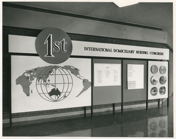
This sign was displayed at the 1st International Domiciliary Nursing Congress which was hosted by the Royal District Nursing Service (RDNS).The 1st International Domiciliary Nursing Congress was hosted by Royal District Nursing Service (RDNS). Mrs. D.(Elsa) Hallenstein, President of RDNS, presided over the opening ceremony with the Prime Minister of Australia, the Hon John Gorton opening the Congress. It was held in Melbourne and ran from the 1st to the 8th of February 1970. Many delegates came from around Australia and overseas; from the World Health Organisation; from the North American continent; from Europe, from Asia and from the Pacific. Black and white photograph showing the sign displayed at the 1st International Domiciliary Nursing Congress. Across the photograph is a long black metal stand, with eight legs, which holds a large board. On the upper quarter can be seen to the left a medium sized black circle which has the lettering '1st' outlined in white on it. To the right of this is the black lettering "International Domiciliary Nursing Congress" in capital letters on a white background. Below the black circle, on a white background, is a large round white globe outlined in black and with black spaced vertical and horizontal grids on it. In the lower centre of this is the black coloured land mass of Australia. Over the left hand top section, and above and to each side of the white globe are different land masses of the world displayed in grey. To the right of this there are two grey sections which are divided vertically with a black line,.and contain information on white sheets. To the right of that is a white section with round photographs in three pairs running down the board.Photographer stamp. Quote No. JE 4royal district nursing service, rdns, mrs d. (elsa) hallenstein, hon john gorton, 1st international domiciliary nursing congress -
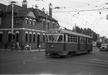 Melbourne Tram Museum
Negative, Wal Jack, 9/02/1951 12:00:00 AM
Black and white negative, by Wal Jack, of PCC 980, northbound bound in Glenferrie Road at High Street with the destination of Kew Cotham Road. The Bank was replaced by a more modern looking building during the 1970's. In the background is the ES&A bank on the corner. Jane Nigro advised 9/9/2020: "1907 Photo of the E. S. & A. Bank on the corner of High Street and Glenferrie Road, Malvern. In 1885 land on corner of Glenferrie Road & High St. (40' x 150') was purchased by E.S. & A. Bank. A condition of sale was that the bank erect on the land a 'substantial brick building to be used as a branch bank', within 24 months. The E.S. & A. Bank, single-storey four roomed brick, was built in 1888. The first manager was Frederick Leonard. In 1907 a second storey, including residential quarters for the manager, was added to bank at a cost of £1400.The Bank was demolished in 1958-9and replaced with present building."trams, tramways, pcc class, glenferrie road, route 69, kew- cotham rd, tram 980 -
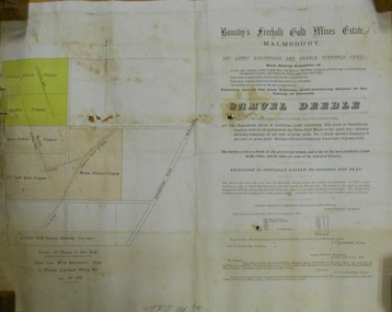 Bendigo Historical Society Inc.
Document - MARKS COLLECTION: BOUNDY'S FREEHOLD GOLD MINES MALMSBURY
Plan/advertisement 1888 for the sale of the Boundy's Freehold Gold Mines Malmsbury, 260 acres of auriferous and arable freehold land. Document contains map of mines, names include O'Connors Freehold Company, Egyptian Company, Queen's Birthday Company, No.1 South Queen Company, Madam O'Connor's company, Extended South Queen's Birthday Company. Scale 10 chains to one inch. Taken from Mr. H. Archdale's Plan by Walter Sleeman, Mining Mgr., Oct 9th. 1888. On RH side of map Daylesford Road to Malmsbury marked. The land is only about two miles from the Malmsbury railway station. On back of document letter from Henry Nutman, Mining Manager, Queens Birthday Company; Report on Plan Walter Skleeman, M.M.; letter to S. Deeble, 35 Queen St., Melbourne with report on mine from George Jenkyn and Mining Manager's Report in Argus 24th.October 1888.mine, gold, boundy's freehold gold mine -
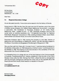 Ringwood and District Historical Society
Document - Folder, Brief history of the Ringwood Secondary College site in Bedford Road, Ringwood, Victoria, since 1905 and subdivision in 1924
Terry Kane and Richard Carter were the authors of the short historyType written notes and plans pertaining to the land titles and history of the Ringwood Secondary College site from 1905, prior to the land being sold by the Borough of Ringwood in 1954 to the Education Department. Transcript of covering letter from Richard Carter to Mr T Kane dated 16 November 2012 - "Re: Ringwood Secondary College As we discussed recently, I have done some research into the history of the site. Going back to 1905, the site, then 26 acres one rood 37 perches, was in the name of Walter James Anderson of 61 William Street, Melbourne, Accountant - most likely a speculator. Title transferred to Theodosia Anderson of 167 Collins Street, Melbourne, Artist - possibly his son - In 1907. Theodosia Anderson was thus the owner when on abortive subdivision Into "110 Splendid Home Sites" as "Bedford Park Estate, Ringwood" took place In 1924, creating Anderson Street, Joyce Street, Adams Street and Graham Road, all of which sank without trace. Theodosia Anderson died In 1933, leaving the property to John Blair, Solicitor of Melbourne and Annie Benson of Melbourne, widow, until title ultimately passed to The Mayor, Councillors and Burgesses of the Borough of Ringwood In 1946. Title was then spilt Into three with 14 acres 0 rood 11 perches being transferred to the Minister of Education on 1954 followed by a further 2 acres 1 rood 26 perches to the Minister In 1956. The balance of the land remains In the ownership of the now Maroondoh City Council as Bedford Park. It Is Interesting that at no stage did any of the land belong to the Commonwealth of Australia, notwithstanding that I always understood It was the site of the P.M.G. Workers Camp after the War. Perhaps the P.M.G. utilized the site by arrangement with the borough of Ringwood; perhaps the camp was on the opposite site of Hill Street (Government Road). More research Is needed on this point. Yours faithfully, CE CARTER & SON PTY LTD Richard Carter Managing Director" -
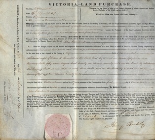 Federation University Historical Collection
Document, Grant, by Purchase, Parish of Burrumbeet, Victoria, 1857, 1857
John Ettershank of Ballarat purchased land for Ninety-three pounds, two shillings and four pence. This was ten acres, two roods and thirteen perches in the County of Ripon Parish of Burrumbeet. The land sold at Ballarat as Lot No 37. The document was witnessed by Sir Henry Barkly, Knight Commander of the Most Honorable Order of the Bath, Captain-General and Governor-in-Chief of the said Colony and Vice-Admiral, at Melbourne, VictoriaThick cream paper, badly stained. Hand written Official seal Dated 16 April 1857 Signed: Henry Barkly -Governor-in-Chief of the Colony Signed: William C Haines - Chief Secretary and Registrarjohn ettershank, ballarat, county of ripon, parish of burrumbeet, sir henry barkly, captain-general, governor-in-chief -
 Kiewa Valley Historical Society
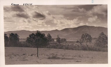
Black and white photograph of farmland, Kiewa, 25/8/38, circa 1938
This photograph was taken in August, 1938 some eight years prior to the establishment of Mt. Beauty as a township. The area was still being used for grazing, and the land was eventually acquired from the local land owners by the State Electricity Commission. The construction of the road, from Tawonga to the High Plains, was commenced in April of this year. This allowed men and heavy equipment to be transported to the work sites for the construction of the Kiewa Hydro Electric Scheme This photograph is important as it shows the upper Kiewa Valley as it was before the establishment of the town of Mt. Beauty. The land has been cleared of natural growth and has been used for grazing cattle. By 1946 housing construction had commenced for the new town of Mt. Beauty and by 1948 street construction in the southern part of the town was completed as far as Hill Street.A black and white photograph of farmland with Mt. Emu in the background. This has been taken from where Mt. Beauty township now stands prior to road making and the erection of houses. A line of trees below the hill line indicates the position of the East Kiewa River. (No. 5 in a set of 8) Handwritten in black ink on the upper left corner of the photograph is the inscription 'Kiewa 25/8/38' and the number 5 has been stamped on the upper right hand corner. On the back is the word 'Velox' which is the name of the photographic paper on which the photo was developed.road construction, kiewa, tawonga, mt. beauty, secv -
 Wyndham Art Gallery (Wyndham City Council)
Photograph, Bindi Chocka Cole, West of Eden, 2015
West Of Eden is the result of an artistic residency at the Western Treatment Plant that took place over three months in 2015. The residency set out to open the minds of the broader community and challenge some of its perceptions to the Plant. This work highlights the natural beauty of the Plant while embracing the fact that, in many ways, this land is not natural at all. Bindi Cole Chocka is a Wadawurrung woman and the Western Treatment Plant is on Wadawurrung land.western treatment plant, residency, photography, wadawurrung -
 Eltham District Historical Society Inc
Document - Property Binder, 813 Main Road, Eltham
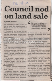
Newspaper article: Council nod on land sale, Diamond Valley Leader, 24 July 2002, Nillumbik Council voted to sell this land. Newspaper article: Grapple on Gateway, Diamond Valley Leader, 11 September 2002, photograph of demonstrators against development of land. Newspaper article: Prominent site protected, Diamond Valley Leader, 6 December 2006, Victorian Civil and Administrative Tribunal upheld decision to refuse development permit, action by Eltham Gateway Action Group. Newspaper article: Daniel's a tree fella, Diamond Valley Leader, 24 July 2002, Daniel Jarvis involved in Planet Ark's National Tree Planing Day, Friends of Falkiner Street Reserve.main road, eltham, property, eltham gateway action group, daniel jarvis, friends of falkiner street reserve. -
 Glen Eira Historical Society
Document - Glencoe Street, 13, Caulfield North
Seven receipts pertaining to land purchase and villa construction at Lot 23, Glencoe Street, Caulfield North, for G F Joyner. This includes a receipt of payment from G F Joyner to designer and builder L E Searle dated 01/08/1924 and a receipt for the payment of a deposit for the purchase of land at Lot 23, Glencoe Street, by G F Joyner to Joseph E Rice dated 19/09/1923. This receipt indicates that the land was owned by Mr Cox. This also includes five receipts for ongoing payments by G F Joyner to Leonard E Searle for villa construction at 23 Glencoe Street, dated from 28/02/1924 to 11/07/1924.caulfield north, glencoe street, beena avenue, murrumbeena, hawthorn road, balaclava road, joyner g f, rice joseph e, cox mr, financial documents, searle leonard e -
 Eltham District Historical Society Inc
Negative - Photograph, Tom Prior, Langlands Bridge, Eltham, c.1900
It is noted in the Reynolds Prior collection (Ivy Reynolds) as the first bridge in Eltham however given the current state of knowledge, this is considered unlikely and there is no other supporting source. John Hunter Langlands, owner of the farm known as ‘Ihurst’ on the west side of Diamond Creek to the south of John Wright Murray’s land, died in 1907. In 1909 his land was subdivided into 100 lots to become the ‘Glen Park Estate’. It is possible that the bidge may have crossed the Diamond Creek to Langland's land along the original alignment of Glen Park Road which used to run between present day Progress Road and Coleman Crescent. SEPP Source (c.1970): Mrs. E.R. Reynolds, Thompson Crescent, Research The Reynolds family were early settlers in Research. The Reynolds/ Prior collection of photographs were taken by Tom Prior, the maternal uncle of Ivy Reynolds, around 1900 and the 60 photos in the album give a fine overview of many of the landmarks of Research and Eltham over 100 years ago. lvy lived in the family home for many years at 106 Thompson Cres Research. Ivy's father, Ernst Richard Reynolds and grandfather, Richard Reynolds, lived at the same address. Ivy's father Richard worked for Mr. Trail on his property in Research. Reynolds Road is named after the family. Mr Tom Prior (wife Eva) worked at the Melbourne zoo. He was very innovative and made his own camera, using the black cloth hood to exclude the light. The photographs are a reminder of the rural nature of Research and Eltham and its rich heritage. This photo forms part of a collection of photographs gathered by the Shire of Eltham for their centenary project book,"Pioneers and Painters: 100 years of the Shire of Eltham" by Alan Marshall (1971). The collection of over 500 images is held in partnership between Eltham District Historical Society and Yarra Plenty Regional Library (Eltham Library) and is now formally known as the 'The Shire of Eltham Pioneers Photograph Collection.' It is significant in being the first community sourced collection representing the places and people of the Shire's first one hundred years.Digital image 4 x 5 inch B&W Neg B&W printsepp, shire of eltham pioneers photograph collection, eltham, langlands bridge, reynolds prior collection, bridge, john hunter langlands -
 Surrey Hills Historical Society Collection
Photograph, Fred Ambler and Family
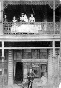
Fred Ambler and family at Albert Mills Premier Land Agency building on the corner of Union and Sunbury Roads, c.1910. Fred had his carpenter and upholstery business on the ground level and his home above. (No.1) Premier Land Agency Building, was built in 1886-7 by Albert Mills, builder, at 122 Union Road, on the corner of Sunbury Crescent, opposite the Railway Station. Photo shows his wife and family. Alfred died in 1890 and the family moved. The Boroondara Standard in 1888 reported: "Splendid block of brick buildings reaching completion in Union Road adjacent to railway line – 2 storey. Frontage 120 feet for Premier Land Agency. Shops at Ground Level." A sepia coloured photograph of a two storey terrace building with 3 ladies and 2 children standing on the balcony. Downstairs, a gentleman stands outside the shopfront beside two prams. There is a child in one pram.albert mills premier land agency building, (mr) fred ambler, union road, carpenter, upholsterer, sunbury crescent -
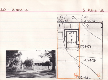 The Beechworth Burke Museum Research Collection
Card (Series) - Index Card, George Tibbits, 5 Kars Street, Beechworth, 1976
George Tibbits, University of Melbourne. Faculty of Architecture, Building and Town & Regional PlanningIndex system that support the research for Beechworth : historical reconstruction / [by] George Tibbits ... [et al]Arranged by street names of BeechworthEach index card includes: street name and number of property, image of property, allotment and section number, property owners and dates of ownership, description of the property according to rate records, property floor plan with dimensions.beechworth, george tibbitsbeechworth, george tibbits -
 Sunbury Family History and Heritage Society Inc.
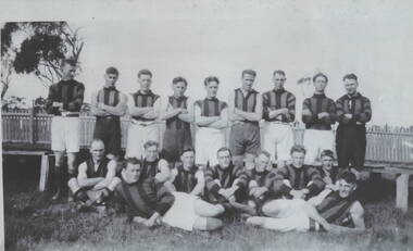
Photograph, Sunbury Football team, C 1890s
The first recorded football match played injured Sunbury was in 1881 when Sunbury played Keilor on Munro's Ground which was located on land bordered by Barkly, Shields, Harker and Evans Streets.By 1892 Sunbury Club officially became known as 'The Swifts". A later game was recorded in 1895 but it wasn't until 1897 that it became a recognised football team at a meeting convened by W.A. Eadie in the Royal Hotel. Later football matches were played on railway land in Evans and Macedon Streets. In 1949 the Shire of Bulla Council passed over 26 hectares of Crown land for a new recreation ground, now the Clarke Oval. Since that time that site has been Sunbury's home ground. Sporting clubs have played an important part in the Sunbury's social life from the latter half of the nineteenth century.A non-digital copied black and white photograph of a men's football team standing and seated in two rows in front of a picket fence. sunbury football club, "the swifts', football, sporting clubs -
 Kiewa Valley Historical Society
Folder - Family History, The Maddison Family, 1968 and later
George Maddison selected land in 1877 between the East and West Kiewa branches of the Kiewa River - known as the "Island". Now Mt Beauty.Pioneer family in the Kiewa ValleyPlastic brown folder with transparent front held by 2 gold metal slide clips. 9 clear plastic sheets holding 4 typed sheets, 3 typed sheets by Ted Maddison 1968, 4 handwritten pages in 1 plastic sleeve and 6 handwritten pages in 1 plastic sleeve (the handwritten sheets are the same as the typed sheets.)maddison family; mount beauty; kiewa valley -
 Greensborough Historical Society
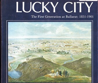
Book, Weston Bate, Lucky city: the first generation at Ballarat: 1851-1901, 1978
The history of Ballarat in its early goldmining days is entwined with the impact on the environment of the area.96 p., illus., maps.non-fictionThe history of Ballarat in its early goldmining days is entwined with the impact on the environment of the area.ballarat, gold rush, gold discoveries victoria -
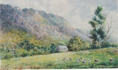 Halls Gap & Grampians Historical Society
Photograph - Coloured
Painting is by Will Rees, an Australian Artist. Subject is a shepherd's hut owned by the D Alton Family on land where D'Alton's Resort now stands.Item is a coloured print of a painting. The range stands in the back ground. A hut stands middle of foreground with a stump in front . A taller gum tree stands to the right side of the photo. Print has soft muted colours.painting, landscape -
 Federation University Historical Collection
Documents, Holmes Family of Ascot: Private papers - Wills, Financial Statements
Private papers relating to the Holmes Family at Ascot. It includes Wills, property settlements, land transfers, wool prices and asset distribution to the family.edith holmes, registration of a firm, live stock prices, lamb numbers, affidavit and statement, memorandum of agreement, land purchase agreement, contractor's account and receipt, solicitor - cuthberts, transfer and conveyance paperstax return, will of violet holmes, distribution of estate of violet holmes, administration account, wool results from dennys,lascelles -
 City of Moorabbin Historical Society (Operating the Box Cottage Museum)
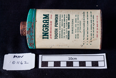
Containers, metal 'INGRAM' tooth powder, c1950
Ingram Tooth powder was popular with settlers who bought land and houses in the post World War 2 estates in the City of Moorabbin c1950 Ingrams Tooth Powder was used throughout Australia and was popular with the families settling in the post World War 11 Estates in the City of Moorabbin c1950A green and white tin that contained 'INGRAM' tooth cleaning powder. lid is missingFront ; INGRAM (T) / ammonium ion / TOOTH / POWDER ............./BRISTOL- MYERS PTY LTD SYDNEY Back ; Instructions for cleaning teeth -
 City of Moorabbin Historical Society (Operating the Box Cottage Museum)
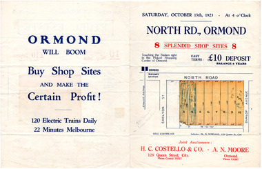
Flyer - North Road, Ormond - H. C. Costello & Co A. N. Moore, 1923
The train line from the city to Frankston was electrified which intensified the sale in the municipality of Moorabbin, particularly land which was in the vicinity of the railway stations.Example of the progress of the Municipality of MoorabbinAdvertising flyer for auction of real estate sales - plan of building blocks for shops for saleNorth Road, Ormond - 8 shop sitesnorth road, ormond, real estate, auctions -
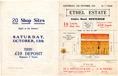 City of Moorabbin Historical Society (Operating the Box Cottage Museum)
Flyer - Ethel Estate, Bentleigh - H. C. Costello & Co A. N. Moore, 1923
The train line from the city to Frankston was electrified which intensified the sale in the municipality of Moorabbin, particularly land which was in the vicinity of the railway stations.Example of the progress of the Municipality of MoorabbinAdvertising flyer for auction of real estate sales - plan of building blocks for saleEthel Estate, Centre Road Bentleigh 10 shop sites in Centre Roadcentre road, bentleigh, real estate, moorabbin, auction, shop sites -
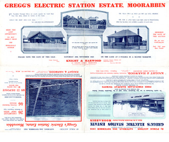 City of Moorabbin Historical Society (Operating the Box Cottage Museum)
Flyer - Gregg's Electric Station Estate, Moorabbin, 1925
The train line from the city to Frankston was electrified which intensified the sale in the municipality of Moorabbin, particularly land which was in the vicinity of the railway stations.Example of the progress of the Municipality of MoorabbinAdvertising flyer for auction of real estate sales - plan of building blocks for saleGregg's Electric Station Estate, Moorabbin 26 business site and 46 home sites - Knight & Harwood pictures of local sites and buildingssouth road, barry street, south avenue, plym street, moorabbin, moorabbin station, gregg, real estate, auction -
 City of Moorabbin Historical Society (Operating the Box Cottage Museum)
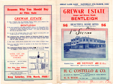
Flyer - Grewar Estate, Bentleigh, 1st Section Sold at Auction, 1926
The train line from the city to Frankston was electrified which intensified the sale in the municipality of Moorabbin, particularly land which was in the vicinity of the railway stations.Example of the progress of the Municipality of MoorabbinAdvertising flyer for auction of real estate sales - plan of building blocks for saleGrewar Estate Bentleigh - 86 Home Sites - H.C. Costello & W. H. Woodpatterson road, jasper road, bentleigh, real estate, auction, grewar -
 City of Moorabbin Historical Society (Operating the Box Cottage Museum)
Flyer - Grewar Estate, Bentleigh, 2nd Section Sold at Auction, 1926
The train line from the city to Frankston was electrified which intensified the sale in the municipality of Moorabbin, particularly land which was in the vicinity of the railway stations.Example of the progress of the Municipality of MoorabbinAdvertising flyer for auction of real estate sales - plan of building blocks for saleGrewar Estate Bentleigh - 73 Home Sites - H.C. Costello & W. H. Woodbentleigh, real estate, auction, grewar, mitchell street, daley street, brewer road -
 City of Moorabbin Historical Society (Operating the Box Cottage Museum)
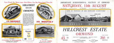
Flyer, 1928
The train line from the city to Frankston was electrified which intensified the sale in the municipality of Moorabbin, particularly land which was in the vicinity of the railway stations.Example of the progress of the Municipality of MoorabbinAdvertising flyer for auction of real estate sales - plan of building blocks for sale with pictures of local housesHillcrest Estate, Ormond - Auction Saturday 11August 1928arker street, holloway street, wild cherry road, ormond, real estate -
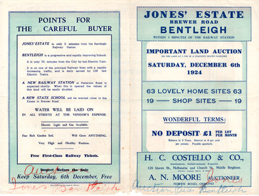 City of Moorabbin Historical Society (Operating the Box Cottage Museum)
Flyer - Jones' Estate, Bentleigh, 1924
The train line from the city to Frankston was electrified which intensified the sale in the municipality of Moorabbin, particularly land which was in the vicinity of the railway stations.Example of the progress of the Municipality of MoorabbinAdvertising flyer for auction of real estate sales - plan of building blocks for saleJones' Estate, Brewer Road Bentleigh - 63 home sites & 19 business sites - H. C. Costello & Co - A. N. Moorepatterson road, brewer road, phillip street, north avenue, real estate, auction, bentleigh, moorabbin