Showing 6464 items matching "architecture."
-
 Kew Historical Society Inc
Plan - Camberwell Panorama Estate, 1923
Subdivision plans and real estate flyers/brochures reveal a number of aspects of urban development and history. The Kew Historical Society's collection of these plans, as well as advertisements extracted from magazines, cover key aspects of community development and architectural history of Kew and Kew Eat as well as surrounding suburbs. While most of the plans in the collection were gifted to the Society by the former City of Kew, a number of other plans and advertisements have been donated by individuals, of which this is an example.Promotional brochure for the Camberwell Panorama Estate. The four page bifold handout advertises 216 home sites bounded by Bulleen Road, The Nook, Fortuna Avenue, and Doncaster Road. Other streets in the subdivision include: Sunburst Avenue, The Moor, and Macedon Avenue. The brochure has been damaged at some time in the past and so masking tape obscures the tram on page 1. Page 2 includes the plan of the subdivision, page 3 information about the site and a locality plan, while page 4 includes photographs and terms of sale. subdivision plans -- balwyn north (vic.), camberwell panorama estate -
Kew Historical Society Inc
Plan - Saxonwood Estate, Doncaster [East]
Subdivision plans and real estate flyers/brochures reveal a number of aspects of urban development and history. The Kew Historical Society's collection of these plans, as well as advertisements extracted from magazines, cover key aspects of community development and architectural history of Kew and Kew Eat as well as surrounding suburbs. While most of the plans in the collection were gifted to the Society by the former City of Kew, a number of other plans and advertisements have been donated by individuals, of which this is an example.Undated, multi-page subdivision plan advertising lots for sale bounded by Blackburn Road, George Street, Windermere Avenue, and Saxonwood Drive in what is currently Doncaster East. Other streets in the subdivision include: Mowbray Court, Stafford Court, Rugby Court, and Robin Hood Court. The front page includes a Birdseye view of the estate which identifies existing and projected civic amenities, as well as the estate's relationship to surrounding suburbs and the city centre. Red crosses on the detailed plan of lots on page two indicate those that have been sold. The final page includes a locality plan. saxonwood estate -- doncaster east (vic.), subdivision plans -- doncaster east (vic.) -
Kew Historical Society Inc
Plan - Charteris Estate, Ivanhoe [East], 1927
Subdivision plans and real estate flyers/brochures reveal a number of aspects of urban development and history. The Kew Historical Society's collection of these plans, as well as advertisements extracted from magazines, cover key aspects of community development and architectural history of Kew and Kew Eat as well as surrounding suburbs. While most of the plans in the collection were gifted to the Society by the former City of Kew, a number of other plans and advertisements have been donated by individuals, of which this is an example.Original 4-page bifold handout advertising 43 residential lots for sale in the Charteris Estate subdivision in Ivanhoe [now classified as Ivanhoe East]. This brochure was created to sell the third section of the estate which it labels as 'The Most Superb Section'. Streets within the subdivision include: Burke Road North, McArthur Road, Castella Street, and the Government Boulevard. In addition to the overall plan spread across pages 2 and 3, each page includes a number of interesting photographs including: a number of the new Burke Road Bridge, a sports ground, Hoyts Picture Theatre in Ivanhoe, a croquet ground, and Ivanhoe shopping centre [named Motor Cross Junction].charteris estate - east ivanhoe (vic), subdivision plans -- ivanhoe east (vic.), d.c. mcarthur, charterisville -
Kew Historical Society Inc
Plan - Pointed Firs Estate, Camberwell North, 1936
Subdivision plans and real estate flyers/brochures reveal a number of aspects of urban development and history. The Kew Historical Society's collection of these plans, as well as advertisements extracted from magazines, cover key aspects of community development and architectural history of Kew and Kew Eat as well as surrounding suburbs. While most of the plans in the collection were gifted to the Society by the former City of Kew, a number of other plans and advertisements have been donated by individuals, of which this is an example.Original multi-page sales brochure of the Pointed Firs Estate, advertised as located in Camberwell North, but now in Balwyn North. The 4-page bifold brochure includes promotional material as well as a detailed plan of the 28 lots for sale, a photograph of the locality with the plan overlaying it, as well as aerial photos and street views. The estate included lots in Doncaster Road, Thackeray Street, Houghton Street, an dMaud Street. pointed firs estate -- balwyn north, subdivisions -- balwyn north (vic.) -
Kew Historical Society Inc
Booklet - Old Kew Golf Links Estate, 1926
Subdivision plans and real estate flyers/brochures reveal a number of aspects of urban development and history. The Kew Historical Society's collection of these plans, as well as advertisements extracted from magazines, cover key aspects of community development and architectural history of Kew and Kew Eat as well as surrounding suburbs. While most of the plans in the collection were gifted to the Society by the former City of Kew, a number of other plans and advertisements have been donated by individuals, of which this is an example.8-page brochure advertising 80 residential home sites for sale in a subdivision called the 'Old Kew Golf Links Estate'. These sites had historic importance in Kew's history as they had previously belonged to Kodak Pty Ltd who were refused permission by Kew Council to use the land for industrial development. The estate, advertised was advertised as being within five miles of Melbourne. The brochure is notable as it includes photographs of Kew East Primary School, the former Kew Golf Club clubhouse, and 'The Moorings' Boathouse (aka Chipperfield's Boat House). The aerial photograph, overlaid with names of notable sites, on the final page is of interest as it shows the area before the intrusion of the Eastern Freeway, which resulted in changing the course of a section of the Yarra River. old kew golf links estate, subdivision -- kew (vic.), subdivisions -- kew east (vic), chipperfield's boathouse, kew east primary school, kew golf club -
Kew Historical Society Inc
Plan - Willsmere Park Estate, Kew, 1926
Subdivision plans and real estate flyers/brochures reveal a number of aspects of urban development and history. The Kew Historical Society's collection of these plans, as well as advertisements extracted from magazines, cover key aspects of community development and architectural history of Kew and Kew Eat as well as surrounding suburbs. While most of the plans in the collection were gifted to the Society by the former City of Kew, a number of other plans and advertisements have been donated by individuals, of which this is an example.Original 4-page, bifold subdivision plan of the Willsmere Park Estate, Kew. The 1926 land sale advertised '40 superb villa allotments' on the 'Yarra Heights'. Streets within the subdivision included: Willow Grove, Kilby Road, Elm Grove and Belford Road. The double page spread on pages 2 and 3 shows the detailed plan of the 40 lots, surrounded by public parkland [Willsmere Park] and the Kew Golf Links. By the time that this version of the plan was released, only the lots on Willow Grove and Kilby Road remained. willsmere park estate -- kew (vic.), subdivisions - kew (vic.), subdivisions -- kew east (vic.), willsmere park -- kew east (vic.) -
Kew Historical Society Inc
Booklet - Yarraleen Estate, Bulleen, c.1966
Subdivision plans and real estate flyers/brochures reveal a number of aspects of urban development and history. The Kew Historical Society's collection of these plans, as well as advertisements extracted from magazines, cover key aspects of community development and architectural history of Kew and Kew Eat as well as surrounding suburbs. While most of the plans in the collection were gifted to the Society by the former City of Kew, a number of other plans and advertisements have been donated by individuals, of which this is an example.Original 8-page booklet advertising a new residential development in Bulleen entitled 'Yarraleen'. The glossy multi-colour brochure includes historic and contemporary photographs of the Yarra Valley, graphic designs of potential residential development, photographs of key facilities (Marcellin College, Golf links, local swimming holes, the Beaver Swim School, Carey Grammar School Oval and grandstand, shopping strips, and farmland).subdivisions -- bulleen (vic.), yarraleen estate -
Kew Historical Society Inc
Plan - 30 Choice Home Sites in Kilby Road, Meldrum Street and Fairway Drive, 1965
Subdivision plans and real estate flyers/brochures reveal a number of aspects of urban development and history. The Kew Historical Society's collection of these plans, as well as advertisements extracted from magazines, cover key aspects of community development and architectural history of Kew and Kew Eat as well as surrounding suburbs. While most of the plans in the collection were gifted to the Society by the former City of Kew, a number of other plans and advertisements have been donated by individuals, of which this is an example.Original 4-page, bifold brochure, one of two in the collection, of home sites created following the creation of the Eastern Freeway which separated a section of land owned by the Kew Golf Club from the main course. The new estate featured 30 lots in Meldrum Street, Kilby Road and Fairway Drive. subdivisions -- kew east (vic.), subdivisions -- kew (vic.), kew golf club -
Kew Historical Society Inc
Plan - 30 Choice Home Sites in Kilby Road, Meldrum Street and Fairway Drive, 1965
Subdivision plans and real estate flyers/brochures reveal a number of aspects of urban development and history. The Kew Historical Society's collection of these plans, as well as advertisements extracted from magazines, cover key aspects of community development and architectural history of Kew and Kew Eat as well as surrounding suburbs. While most of the plans in the collection were gifted to the Society by the former City of Kew, a number of other plans and advertisements have been donated by individuals, of which this is an example.Original 4-page, bifold brochure, one of two in the collection, of home sites created following the creation of the Eastern Freeway which separated a section of land owned by the Kew Golf Club from the main course. The new estate featured 30 lots in Meldrum Street, Kilby Road and Fairway Drive.subdivisions -- kew east (vic.), subdivisions -- kew (vic.), kew golf club -
Kew Historical Society Inc
Plan - Burke Road Junction Estate, East Kew, 1940
Subdivision plans and real estate flyers/brochures reveal a number of aspects of urban development and history. The Kew Historical Society's collection of these plans, as well as advertisements extracted from magazines, cover key aspects of community development and architectural history of Kew and Kew Eat as well as surrounding suburbs. While most of the plans in the collection were gifted to the Society by the former City of Kew, a number of other plans and advertisements have been donated by individuals, of which this is an example.Original 4-page bifold brochure advertising the Burke Road Junction Estate in Kew East. Advertised for sale in 1940, the estate comprised 16 'Central Allotments' fronting High Street, Kilby Road, and Glass Street. Pages 1 & 4, the front and back covers, includes a panoramic photograph of the junction which features a number of shops still extant, but also with buildings long demolished and redeveloped. These include the petrol station and the dairy on the southeast and southwest corners of Burke Road and High Street/Doncaster Road. The dairy includes a statue of a cow on its roof. Pages 2 & 3 include a detailed plan of the estate. subdivisions -- kew east (vic.), burke road junction estate -
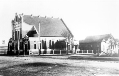 Surrey Hills Historical Society Collection
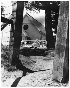
Photograph, Surrey Hills Methodist Church in 1918, 1918
The original Methodist (Wesleyan) Church was built on the corner of Alexandra Crescent and Windsor Lane in 1888. It was enlarged in 1892. In 1908 this building was removed to Valonia Avenue by horse-drawn dray. The brick church was built in 1915 after which the earlier building became the Sunday School. In 1977 the Methodist Church joined with others to become the Uniting Church. In more recent times, the brick church has been painted but architectural details visible in this photo can still be discerned.Black and white photo of a brick and rendered building taken from diagonally opposite across Canterbury Road looking to the north-west. The church sits behind a woven-wire fence with an opening at the front and at the side to a portico off Valonia Street. On the RHS is the church hall and on the LHS a small part of the adjacent house can be seen.surrey hills methodist (wesleyan) church, surrey hills uniting church -
 Warrnambool and District Historical Society Inc.
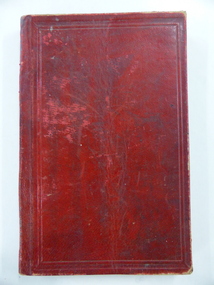
Book, John Ross notebook, 1890s
This small note book belonged to John Ross, the Warrnambool Town Surveyor and Engineer (1889-1906 & 1913-1914). The book lists the levels taken for the benefit of contractors undertaking jobs for the Warrnambool Council from 1898 to 1902. The jobs include ‘Russells Creek from the Merri River upwards’, ‘Outlet at the Flume’, ‘Guns at the Battery’ and Drainage from the Terminus Hotel to the end of the Japan Street Tunnel’. John Ross was also in private practice with the architectural firm of Ross and Jackman. This notebook is of considerable interest because it is an original note book that belonged to John Ross, the Warrnambool Town Surveyor and Engineer in the late 19h century and early 20th century. The note book contains important information on the engineering projects in Warrnambool and district from 1898 to 1902. This note book has a red leather cover. The cover is a little creased. The inside pages have ruled red lines and printed headings regarding the levels taken of a site and the location of the site (1898 to 1902). The engineer’s entries in the printed columns are handwritten , mostly in pencil. The inscription on the first page is handwritten in black ink. ‘Jno C Ross, Town Surveyor Wbool 19/5/98’ john ross, warrnambool town council, history of warrnambool -
 Glen Eira Historical Society
Document - Kahlyn, 70 Bambra Road, Caulfield North
A three page black and white photocopy of a Caulfield Conservation Study of Kahyln House, formerly Kynaston, 70 Bambra Road, Caulfield North, by Andrew Ward in August 1994. The report describes key architectural features of Kahlyn House and gives a brief history of the property’s ownership. The study includes a photograph of the exterior of Kahlyn. The file also includes an undated, unattributed colour photograph (100mm x 150mm) of the exterior of Kahlyn. An undated, unattributed black & white photograph digital version only.danphy catherine, anderson grace, beauchamp horatio, murray reginald, murray kynaston l, holst frederick, ward andrew, hudson street, caulfield, caulfield north, bambra road, kahlyn private hospital, mansions, hospitals, houses, architectural styles, towers, victorian style, verandahs, kahyln, kynaston -
Glen Eira Historical Society
Article - Long Street, 10, Elsternwick
Two items about this property: A type written letter dated 03/11/1988 from Rosalind Landells and Hilary Bullock regarding the history of the occupants of 10 Long Street Elsternwick from 1889-1974. Included is a handwritten page of working notes, undated and unattributed listing the occupant history. An advertisement unsourced, dated 26/5/2006 for the forthcoming auction of 10 Long Street. The advertisement describes key architectural and other features of the house and includes a copy of a colour photograph.elsternwick, long street, advertisements, victorian style, land sales, architectural features, auctions, depression 1890s, land subdivision, munro john p, reynolds i a miss, bainbridge f f, ebbs william h, hunt harry, turner m c miss, hobbs cecil h, mcgillivray e mrs, bowles james, place thomas e, murray herbert, mcbride george, homeman george e, answerth l. m mrs, newling arthur, swann herbert c, matheson alfred, hannett r e, sullivan j, bullock hillary, landells rosalind -
Glen Eira Historical Society
Article - Long Street, 22, Elsternwick
Two items in the file (1) Typewritten notes, dated 03/02/1988, written by Mrs Rosalind Landells and researched by Miss Hilary Bullock regarding the history of 22 Long Street, Elsternwick and the street in general. Both sides of the page have notes, but are more or less the same in content. (2) The second item is an advertisement, dated 02/03/2005, source unknown, for 22 Long Street, Elsternwick regarding the sale of the house. The architectural and other features are described a copy of a photograph is included.elsternwick, caulfield grammar, rogers mark, long street, ripponlea, landells rosalind, caulfield, sargood, bullock hilary, glenhuntly road, victorian style, architectural features, st george’s road, buxton, advertisements, land sales, auctions, land subdivisions, depression 1890s, property developers, real estate agents, real estate agencies, corner stores, businesspeople -
Federation University Historical Collection
Essay - Document, Anne Beggs Sunter, Mining the Education Lode: The History of Mining Education in Ballarat by Anne Beggs Sunter
"Mining the Education Lode: The History of Mining Education in Ballarat" by Anne Beggs Sunter covers the Early History, Community Impact, Decline of Gold Mining, New Avenues, The Baby Boomers, Mergers and New Directions, The 1990s, Innovations, Associateship to Degree, Staff, Heads of Department, Graduates, Scholarships and Prizes, Architectural Heritage, Occupational Health and Safety and Environmental Management (Rehabilitation), relating to the Ballarat School of Mines. Anne Beggs-Sunter is an historian who lectures in the School of Arts at Federation University Ballarat.26 A4 page thesis concerning the history of mining education in Ballarat. ballarat school of mines, school of mines, mining education, ballarat, anne beggs-sunter, beggs-sunter, anne beggs sunter, mining the education lode, alumni, mining, gold mining -
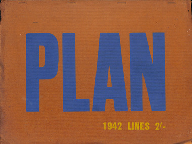 Robin Boyd Foundation
Journal, Students Society of the R.V.I.A (Melbourne), Lines, 1942
Robin Boyd was the editor and designer of this volume. Lines was an annual journal of the Students Society of the R.V.I.A. This is a very rare copy. Most articles have a byline, but the ones without are perhaps by Robin Boyd. There is such an article 'An Australian Architecture?" (2 pages) which is perhaps by Boyd. The journal also contains an article 'The Democratic City' by architect Dr Ernst Fuchs and an article 'An Australian School of Painting?' by John Reed, Deputy President Contemporary Art Society, founder of Heidi with his wife Sunday Reed.rvia, architecture, ernst fuchs, roy simpson, john reed, walsh st library -
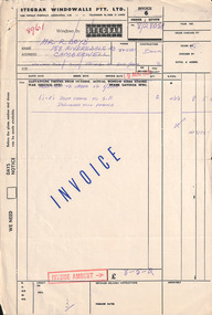 Robin Boyd Foundation
Document - Invoice, Stegbar Windowwalls Pty Ltd, 19.08.1958
Two invoices to Robin Boyd for the windowalls and additional door frames at 290 Walsh Street. The three windowwall items are drawn with specifications. In 1952-53, Robin Boyd designed the Stegbar ‘Windowall’ - a prefabricated, structural framing/glazing system - to create a wall of windows. These ‘Windowalls’ were used extensively in domestic architecture across Australia from the 1950s to the 1970s. Boyd also designed the factory and showrooms for Stegbar Limited. The Walsh Street Archive holds exterior and interior perspectives of the building. Two foolscap pages. stegbar, windowall, ohm2022, ohm2022_35 -
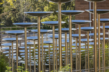 Nillumbik Shire Council
Public Art: Robert BAINES (b.1949, Melb, Aus), Robert Baines, Transaction (Location: entrance, Nillumbik Shire Council Offices, Civic Drive, Greensborough), 1994
The site specific sculpture is located at the entry to the office of Nillumbik Shire Council. It was commissioned in 1994 by the Shire of Diamond Valley for their 20 year celebration. Baines was chosen from a short list of three artists. He is an internationally renowned artist, particularly in the field of gold and silver smithing. 'Transaction' takes on the visual and aesthetic vocabulary of its surroundings. It is a statement of the geometry and idiosyncrasy of its immediate site. The series of arcs are reinterpreted into longitudinal curves in the sculpture. It is a transaction between the place and the anticipated entry to the building. The title also suggests the flow of civil and administrative procedures that take place daily within the Shire's offices. A large cascading form in stainless steel. Multiple rows of concave dishes set on long steel stems, which progressively increase in size as they rise in height. The work plays elaborately with perspective, and its repeated shapes are arranged in a orderly mathematical series. It faces a wheelchair ramp lined with polished steel rails, and is integrated with the architectural features of its forecourt setting, for which it was designed. The piece is sited in a small garden area and can be viewed from within the building's foyer. In bright sunlight, its dish-shapes cast elliptical shadows across walkways and lawns. N/Apublic art, transaction, ekphrasis2017, stainless steel, disks, poles, council -
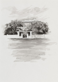 Bayside Gallery - Bayside City Council Art & Heritage Collection
Work on paper - ink and watercolour, Annette Meikle, Karinga, 1977
In 1977, artist Annette Meikle undertook a commission to illustrate a book recording stories of places and people in the Bayside area. It was published in 1978 as Sandringham Sketchbook, with text by Elizabeth Waters. The sketches were intended to record remaining examples of Bayside’s early architecture and environment, as well as reflect newer architectural changes. Meikle went on to donate 22 of these sketches to Bayside City Council in 2003. This inter-war house located at 60 Bluff Road, Black Rock, was built in 1926 for former Scotland Yard and Criminal Investigation Branch detective Horatio Reginald Clarence McWilliams. When McWilliams died it was found that he had taken extreme measures to protect his security. All the windows were nailed shut, a network of burglar alarms ran through the house and a complicated underground air raid shelter had been built in the garden. The security measures were at odds with the name of the house – Karinga or Karinya – an Aboriginal word meaning peaceful, happy home. Later residents of ‘Karinga’ included Senator Don Chipp and his family. The property has since been demolished and apartments have been built on the land.Annette Meikle, Karinga 1977, ink and watercolour, 32 x 23.5 cm. Bayside City Council Art and Heritage Collection. Donated by the artist, 2003annette meikle, sandringham sketchbook, elizabeth waters, black rock, karinga, karinya, horatio reginald clarence mcwilliams, senator don chipp, historic house, bluff road -
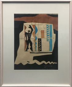 Federation University Art Collection
Work on paper - Printmaking - Lithograph (Limited Edition), Le Corbusier, 'Modulor' by Le Corbusier, 1956, 1956
Le Corbusier (or Charles-Édouard Jeanneret-Gris) (6 October 6, 1887 – August 27, 1965) Born Chaux-de-Fonds, Switzerland Studied at the local art school Began to study architecture in 1905 With Amedee Ozenfant founded the journal “L’Esprit Nouveau” in 1920 Became a French citizen in 1930 La Corbusier was a Swiss-French architect, designer, painter, urban planner, writer, and one of the pioneers of what is now called modern architecture. He was born in Switzerland and became a French citizen in 1930. His career spanned five decades, with his buildings constructed throughout Europe, India, and the Americas. (Wikipedia) The Modulor is an anthropometric scale of proportions devised by the Swiss-born French architect Le Corbusier (1887–1965). It was developed as a visual bridge between two incompatible scales, the imperial and the metric system. It is based on the height of a man with his arm raised. It was used as a system to set out a number of Le Corbusier's buildings and was later codified into two books. (wikipedia) This item is part of the Federation University Art Collection. The Art Collection features over 1000 works and was listed as a 'Ballarat Treasure' in 2007.Limited edition lithograph after an original collage by Le Corbusier, probably executed in Mourlot Workshop. art, artwork, le corbusier, modular, mourlot workshop, lithograph, colour lithograph, printmaking, aavailable -
 Robin Boyd Foundation
Certificate, Life Fellow from Royal Australian Institute of Architects, 1970
Robin Boyd, a Fellow of RAIA since 1958, won the RAIA Gold medal in 1969 and then was elected Life Fellow the following year in 1970.Certificate from The Royal Australian Institute of Architects stating that Robin Boyd has been elected Life Fellow on 9th February 1970. It is signed by the President and Secretary. Certificate is registered No 5773. This is in a timber frame.The Royal Australian Institute of Architects. This is to certify that Robin Gerard Penleigh Boyd of Melbourne, Victoria has been elected a Life Fellow of the Royal Australian Institute of Architects, founded in the year of our Lord One Thousand Nine Hundred and Twenty Nine (1929) as The Australian Institute of Architects, and incorporated in the year of our Lord One Thousand Nine Hundred and Thirty as Royal Australian Institute of Architects for the Advancement, Protection, and Elevation of Architecture. In Witness whereof the Common Seal has been hereunto affixed as required under the Articles of Association 9th February, 1970. Signed by president and Secretary. Registered No. 5773. The reverse has Dean's framing sticker. Handwritten No 7436/D.royal australian institute of architects, fellow, raia fellow, robin boyd -
Glen Eira Historical Society
Drawing - St Aloysius Church, Caulfield
Two Photocopies of a pamphlet from May 1924 signed A. L Kenny about the newly built St Aloysius Catholic Church on Balaclava Road, Caulfield. The pamphlet features a detailed description of the architectural features of the interior and exterior, including Gothic spire and nuns tubrine. The pamphlet is across 6 A4 pages for both copies. Included within are several photographs, of varying sizes, of the interior and exterior of the church, a photograph of the architect Bart Moriarty and an illustration of the proposed Presbytery. Within is a list of benefactors, their gifts to the church and the value of each gift.st aloysius’ church, o’ brien fr., parish of caulfield, returned soldiers and nurses caulfield, balaclava road, altar society, moriarty bart, caulfield., kenny a. l., popular summer girls, kehoe miss, rattray mrs, power mr., power mrs., kelly mrs., gleeson t. mr., gleeson t. mrs, foley m., guilfoyle, beth mr., murphy i. l mrs., killorn mr., walsh mr, radcliffe mrs., klaer d. miss, hogan a. miss, hennessy lady, pilkington m. miss, pilkington e. miss, connolly mr., hogan brothers, o’ loughlin count, o’ loughlin mrs, levers miss, burke t. m. mr, burke t.m. mrs, confoy t. j. mr, confoy t. j. mrs., harrington mrs., eccles e. mr., eccles e. mrs., dorgan d. mr, dorgan d. mrs, wren j. mr, wren j. mrs., kisby mrs, charlton h. miss, foulshan w mr., pilington mrs, mcgrath m. mr., mcnamara mrs, cornack mrs., connolly e. a. mr., malone mrs., wharton mr., wharton mrs., donoghue d. mr, foulsham w. mrs, sweeney p. mr., sweeney p. mrs., adams h. m mr, adams h. m mrs., vaughan d. e. mr, vaughan d. e. mrs., mclennan mrs, morgan myra miss, boland catherine miss, hennessy n. mr., casey s.p. mr, casey s.p. mrs., mclntyre e. miss, mannion mr., bennett mrs., drummond mrs., lectie mrs., catholic church, churches, gothic (revival) architecture, architectural features, architectural styles, architects, clergy residences, church furniture, religious ceremonies, nuns, communion rails, altars, fonts, pulpits, pews, stained glass, windows, organs, sculpture, cast iron work -
Glen Eira Historical Society
Document - Grace Darling, Bond Street, 1, Caulfield North
A photocopy of a four page extract of a Caulfield Conservation Study by Andrew Ward, dated 08/1994, on the house Grace Darling, located at 1 Bond Street, Caulfield North. The study describes the house and its stables, including architectural features, and provides a history of the property owners and a statement of the house’s historical significance to Caulfield and horse racing. The study includes a photograph of the house exterior (100mm x 150mm), a photograph (100mm x 150mm) of the stables exterior and a photograph (130mm x 100mm) of the interior of the stables.grace darling, bond street, caulfield conservation study, ward andrew, architectural features, architectural styles, victorian style, williams john, balaclava road, reid j g, duffet j, caulfield cup, caulfield north, victorian amateur turf club, booran road, reddan road, melbourne cup, historical buildings register, national estate register, national trust register, horse racing, race horses, race horse trainers, jockeys, stables, loose boxes, timber houses, roofs, cast iron work, lofts, bricks -
 Eltham District Historical Society Inc
Photograph, George W. Bell, St Mary's Catholic Church, cnr Main Road and Henry Street, Eltham, c.1960
St Mary's Catholic Church, cnr Main Road and Henry Street, Eltham was opened/blessed October 13, 1912. The wooden church was built to replace an earlier brick church also known as St Mary's (1865-1912), which had been situated on the main road near present day Wingrove Park. The church and land cost £1,400 (Evelyn Observer). The wooden church was destroyed by fire in 1961. A new modern architecture (1960s) style church was erected - Our Lady of Help Christians Church. This photo forms part of a collection of photographs gathered by the Shire of Eltham for their centenary project book,"Pioneers and Painters: 100 years of the Shire of Eltham" by Alan Marshall (1971). The collection of over 500 images is held in partnership between Eltham District Historical Society and Yarra Plenty Regional Library (Eltham Library) and is now formally known as the 'The Shire of Eltham Pioneers Photograph Collection.' It is significant in being the first community sourced collection representing the places and people of the Shire's first one hundred years.Digital image 4 x 5 inch B&W Neg Print B&Wsepp, shire of eltham pioneers photograph collection, eltham, roman catholic church, church, catholic church, henry street, main road, st marys catholic church -
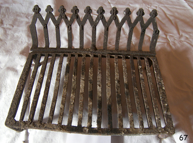 Flagstaff Hill Maritime Museum and Village
Domestic object - Fire grate, William Stephens, 1900 to 1910
W Stephens operated a foundry in south Melbourne around 1900 the company made many cast iron architectural and domestic items that were decorative in design and used in the building industry of the time. Stephens Excelsior Foundry specialised in making decorative cast iron balustrades and brackets with intricate lacework used on verandas in the late Victorian period found in Australian homes. The company also made many other items of cast iron including fire grates down to wheel barrow wheels as their 1901 and 1908 catalogues describe. A domestic item made by one of Melbourne's early foundries that specialised in making decorative architectural cast iron items of all types that can be seen in many building still in use today throughout Australia.Fire grate cast iron with four legs and back support. Embossed "W.STEPHENS REGISTERED" on the back.flagstaff hill, warrnambool, shipwrecked coast, flagstaff hill maritime museum, maritime museum, shipwreck coast, flagstaff hill maritime village, great ocean road, fire grate -
 Federation University Historical Collection
Book, Railway Practice: a collection of working plans and practical details of construction in the public works of the most celebrated engineers, 1847 (exact)
A green cloth hard cover book. Title and author's name are engraved in gold on spine. This is the 3rd edition, first series with black and white illustrations. It describes the engineering practices of the early days of British railroads. The book includes (series 1 to 4)and it contains, roads, tramroads and railroads, bridges, aqueducts, viaducts, wharfs, warehouses, roofs, and sheds, canals, locks, sluices, & the various works on rivers, streams, etc., harbours, docks, piers and jetties, tunnels, cuttings and embankments, the several works connected with the drainage of marshes, marine sands, and the irrigation of land, water-works, gas-works, water-wheels, mills, engines.civil engineering, railway practice, rail constructions, s c brees, western railway great britain, public works, railroads, canals, s.c. brees, samuel brees, samuel charles brees -
 Federation University Historical Collection
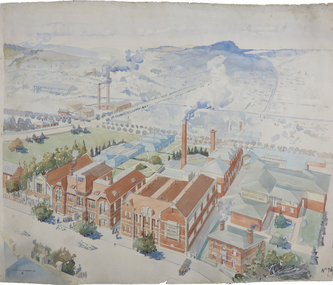
Painting - Artwork Plan, Birdseye View of the Ballarat School of Mines, 1915, 1915
Herbert Leslie (Les) COBURN (1891-1956) Australia This work was commissioned by the SMB Council to hang in its chambers. It envisions the new Junior Technical School building and was illustrated in the same year the Ballarat Technical Art School building officially opened. Les Coburn was a student at the Art School between 1908 and 1916. Coburn and his business partner, Percival Selwyn Richards (1865-1952), became joint instructors in architecture and building construction at the school from 1920, with Coburn continuing until 1948. Watercolour plan drawing on paper of Ballarat School of Mines showing the Museum, Administration building, Technical Art School, and proposed Junior Technical School, Ballarat School of Mines Botanical Gardens, and the Ballarat Gaol Governor's Residence. ballarat school of mines museum, ballarat technical art school, ballarat junior technical school, watercolour, cr. h. l. coburn, aerial, ballarat school of mines, birdseye view, h.l. coburn, herbert leslie coburn, les coburn -
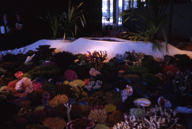 Robin Boyd Foundation
Slide, Robin Boyd, 1967
Robin Boyd was appointed Exhibits Architect for the Australian Pavilion at Expo ‘67 in Montreal. The garden outside the pavilion featured a sculptural pool, a coral display, animal pool, a pit for kangaroos and Eucalypts and other native plants. The indoor exhibits covered aspects of Australian art and culture, architecture, industrial design and scientific innovation, such as the Snowy Mountains Hydro-Electric Power Scheme, the Parkes radio telescope, the design of Canberra, and the Australian way of life. The coral display was prepared by E Grant, a fisheries research biologist.Colour slide in a mount. Coral display depicting the Great Barrier Reef, Australian Pavilion, Montreal Expo '67, Canada. Made in Australia / 17 / MAY 67M6 / 6 (Handwritten with red pen) / 10 (Handwritten)expo 67, montreal, robin boyd, slide -
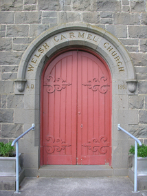 Ballarat Heritage Services
Photograph - Photgraph, Door at Carmel Welsh Church, Sebastopol, c2017
Carmel Welsh Church is located at 365 Albert Street, Sebastopol and is the only identified Welsh Presbyterian church surviving in Victoria,. It was built in 1865-6 to the design of Henry Richards Caselli, and of distinctive architectural character combining round arched windows of almost a Renaissance character, mediaevalising buttresses, and extremely chunky gable eaves of a domestic character, including square finials and raking brackets. It was established in 1861, the members and adherents were predominantly Welsh, the Welsh language was spoken freely and there were regular services in Welsh.Digital photograph of the door of the bluestone Welsh church, Sebastopol, Ballarat.carmel welsh church, sebastopol, bluestone, church, henry richards caselli, welsh