Showing 23748 items
matching sardine-creek
-
 Eltham District Historical Society Inc
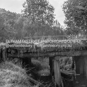
Negative - Photograph, J.A. McDonald, Heidelberg-Kinglake Road, 11 May 1961
Yow Yow Creek bridge 11 May 1961Record of various Shire of Eltham infrastructure works undertaken during the period of 1952-1962 involving bridge and road reconstruction projects, sometimes with Eltham Shire Council Project Reference numbers quoted. It was during this period that a number of significant improvements were made to roads and new bridges constructed within the shire that remain in place as of present day (2022). In many situations, the photos provide a tangible visible record of infrastructure that existed throughout the early days of the Shire. The album was put together by or under the direction of the Shire Engineer, J.A. McDonald.1961-05-11, heidelberg-kinglake road, infrastructure, bridge construction, shire of eltham, yow yow creek -
 Eltham District Historical Society Inc
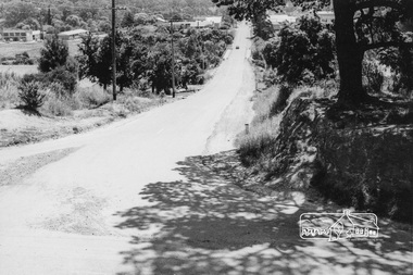
Photograph, Looking west along Bridge Street, from Main Road, Eltham, February 1968, Feb 1968
Shows the Diamond Creek bridge and part of Susan Street In February 1968 an unknown person took a series of photos from the Eltham Hotel at Pitt Street heading north along Main Road through the shopping centre to just north of Elsa Court covering the length of the section of Main Road which was duplicated shortly thereafter. Shows the condition and environment of the streesscape of Main Road, Eltham immediately prior to the duplication between Pitt Street and Elsa Court through the shopping centre. Also shows a number of shops and businesses that operated at that time.Black and white photographduplication, eltham, main road, bridge street, susan street -
 Ballarat Heritage Services
Souvenir - Postcard Booklet Image, The Blowhole, Hepburn, Victoria, c1945
The Blowhole was blasted by Chinese miners to divert Sailor's CreekA black and white photographic image of the Blowhole at Hepburn.blowhole, hepburn, sailors creek -
 City of Greater Bendigo - Civic Collection
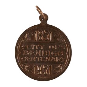
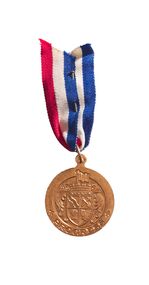
Medal - City of Bendigo Centenary Medal, Stokes and Son
Medal commemorating the centenary of the establishment of a settlement on Bendigo Creek. Stokes & Sonsobverse; 1851 / City of Bendigo Centenary / 1951. Reverse: In centre: Coat of arms (Bendigo), Below Progresscity of greater bendigo medals -
 City of Greater Bendigo - Civic Collection
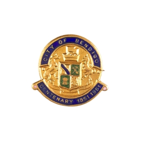
Decorative object - City of Bendigo Centenary decorative pin, Stokes and Son, 1951
Medal commemorating the centenary of the establishment of a settlement on Bendigo Creek. (.1) Small, circular, gold pin with blue and green enamel. below. (.2) Seventeen numbered paper envelopes containing single pin.Face of pin has the City of Bendigo Coat of Arms in relief with 'City of Bendigo' above and 'Centenary 1851 - 1961' city of greater bendigo medals -
 City of Greater Bendigo - Civic Collection
Medal - City of Bendigo Centenary Medal with ribbon, Stokes and Son
Medal commemorating the centenary of the establishment of a settlement on Bendigo Creek. Stokes & Sons pressed medal with gold finish to commemorate the 100th anniversary of the establishment of Bendigo. obverse; 1851 / City of Bendigo Centenary / 1951. Reverse: In centre: Coat of arms (Bendigo), Below Progresscity of greater bendigo medals -
 Falls Creek Historical Society
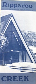
Booklet - Ripparoo Lodge, 1973
Ripparoo Lodge was one of the earliest Lodges established in the Falls Creek Village. In the 1960s, Bob and Noelene Lee moved to Falls Creek to run Ripparoo Lodge. They later built Attunga Ski Lodge. Both of these lodges still operate successfully in the 2020s.This brochure is significant because it represents one of the early lodges at Falls Creek. A fold out brochure printed in blue and white, it include some images and cartoons of people enjoying hospitality at Ripparoo. Information on tariffs and services is included.Title - Ripparoo The happiest ski lodge in the village.falls creek accommodation, ripparoo, falls creek lodges -
 Falls Creek Historical Society
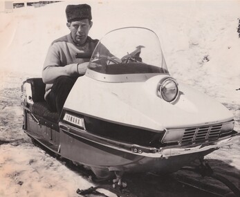
Photograph - Julian Newton Brown on Yamaha SL 351
Julian Newton-Brown arrived at Falls Creek in 1957. He had studied Pharmacy at Melbourne University. After developing a love for the mountains, Julian moved to Mt. Beauty and then Falls Creek. He worked for the SEC in the test laboratory at Rocky Valley reading weather instruments. By working several jobs, Julian was able to build a small lodge of 10 beds named “Arundel”, located at 18 Slalom Street, Falls Creek. The lodge is now the “Elk at Falls”. Arundel prospered and Julian extended it to include 32 beds and changed its name to "Julian’s” in 1961. When alcohol restrictions were eased in Falls Creek, Julian built a night club which he called “Big Julian’s” and later “THE MAN”. When Julian and his wife Beth retired and left Falls Creek, their son took over running the lodge. An active community man, Julian was a member of the Falls Creek Chamber of Commerce, a member of the SES, a stakeholder in Falls Creek, an author and a documentary maker. Julian Newton-Brown died in May 2020. In 2003 when this flyer was published operation of Julian's Lodge transferred from Julian and his wife Beth to their son Charlie Brown, a former Australian Champion and World Cup skier and his wife, Bena.This item is significant because it gives details of an important lodge at Falls Creek, Victoria.A black and white image of Julian Newton Brown testing a Yamaha SL 351 in 1968.julian's lodge, julian newton brown, falls creek ski lodges, accommodation falls creek, charlie brown -
 Kiewa Valley Historical Society
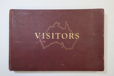
Visitors Book - Nissen Paradise, Welcome to our Nissen Paradise - Ski Nissen School - 1953 to 1960
Nissen Lodge was built by 1953 at Falls Creek. The first lodge at Falls Creek was built in 1947 by SECV staff members. By the 1954 Ski Season, Falls Creek Alpine Village had 10 club lodges, plus a ski tow house and a commercial lodge that both provided skier accommodation. Several other club lodges were under construction. The Nissen Alpine Club operated a rope tow with a 240m rise in altitude..Ski lessons were also available. Re: Tony and Skippy St Elmo Beveridge See KVHS 1113 By 1953, the SECV was issuing entry permits for private cars used by skiers with bookings in a Falls Creek lodge.The Nissen Ski Lodge was one of the early ski lodges at Falls Creek. Toni St Elmo Beveridge was involved in the early development of skiing at Falls Creek including assisting with the building of the early lodges, and establishing the Nissen Ski School. See KVHS 1113. The book was later used for visiors to the KVHS museum located in the old Tawonga South School.Deep red, bound, thick cardboard book with gold outline of Australia and 'Visitors" on the centre front. Many pages each with a column for Date, Name in Full and Address in Full. Written in ink and pencil both sides of each page with the first date being 14 - 6 - 1953 to 17th September 1960. Entries follow from 1985 to 1994 when the closure of the display at the old South Tawonga Primary School is noted by the KVHS Secretary. The book also has 'Tony & Skippy St Elmo Beveridge' on its cover page. nissen ski lodge, visitors book falls creek, nissen school -
 Orbost & District Historical Society
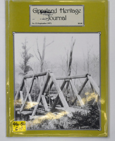
journal, Gippsland Heritage Journal, September 1997
This issue was edited by Meredith Fletcher.This item is a useful reference on the history of Gippsland.A 64 pp magazine, titled Gippsland Heritage Journal. The cover is olive green with a b/w photograph of the Snowy Creek bridge at Mitta Mitta in 1914. The magazine is dated September 1997 and is covered in plastic. It contains photographs and articles on the history of Gippsland.On the outside back cover is a library barcode. On the front is a call no. 994.56 GIPgippsland-heritage-journal history-gippsland -
 Ringwood and District Historical Society
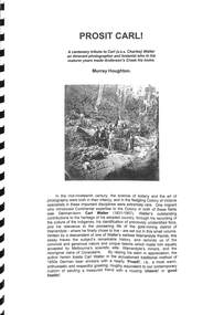
Book, Murray Houghton, Prosit Carl! - A Tribute to Carl (a.k.a. Charles) Walter, 2007
A centenary tribute to Carl (a.k.a. Charles) Walter, (1831-1907), an itinerant potographer and botanist who in his maturer years made Anderson's Creek his home. Includes photographs attributed to Walter, and anecdotes and recollections of author Murray Houghton's ancestors."... By raising his stein in appreciation, the author herein toasts Carl Walter in the accostomed traditional method of 1850s German beer drinkers with a hearty 'Prosit!', i.e., a most warm, enthusiastic and respectful greeting, roughly equivalent to our contemporary custom of saluting a treasured friend with a rousing 'cheers!' or 'good health!'." -
 Halls Gap & Grampians Historical Society
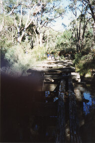
Photograph - Coloured, C 1980s
This is a photo of one of the trestle bridges on the Heatherlie Quarry train line. The bridge is located near the current location of "The Pines" campground.The photo is a "front on" of a derelict trestle bridge crossing a shallow creek; many sleepers are missing and thick bush and trees surround the bridge. There are four adults at the end of the bridge, one standing and three seatede. The bottom left hand side of the photo is blurredstructures, bridges, quarrying, heatherlie -
 Bendigo Historical Society Inc.
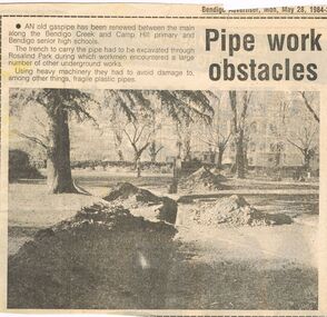
Newspaper - CASTLEMAINE GAS COMPANY COLLECTION: BENDIGO ADVERTISER, 28/05/1984
Cut out from the Bendigo Advertiser of Monday May 28, 1984. ''Pipe work obstacles'' An old gas pipe has been renewed between the main along the Bendigo creek and Camp Hill primary and Bendigo senior high schools.newspaper, bendigo advertiser, gas related item -
 Bendigo Historical Society Inc.
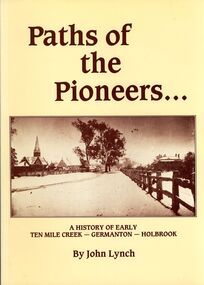
Book - STRAUCH COLLECTION: PATHS OF THE PIONEERS
Soft covered book Paths of the Pioneers, A history of early Ten Mile Creek - Germanton - Holbrook , compiled from the files of the newspapers which have served Germanton, Holbrook, Albury and Wagga Wagga, 104 pages with a map and black & white photographs.John Lynchhistory, australian, new south wales, history-nsw-holbrook-germanton-ten mile creek -
 Bendigo Historical Society Inc.
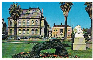
Postcard - LAW COURTS, BENDIGO
Postcard: image shows Law Courts, Bendigo. Former Police Station on RH side of Law Courts, beside Police Station is a Victorian house, bordering the Bendigo Creek and entry into Rosalind Park. In foreground, ivy basket, statue in Conservatory Gardens.Plastichromebendigo, buildings, law courts, bendigo, law courts, police station -
 Bendigo Historical Society Inc.
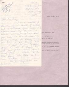
Document - LETTER: DALEY FAMIILY (EMU CREEK, BENDIGO), 13th February, 1975
Letter re Daley family (Emu creek, Bendigo) 13/2/1975 from E Murray to BHS. Supplied details of family post 1853 - details of number of children and names etc. Request for further information - no substantial answer to request..person, individual, daley family -
 Bendigo Historical Society Inc.
Map - SALISBURY : COUNTY OF BENDIGO, 1965
Map. Salisbury, County of Bendigo, Pompapiel, Yallook, Yarraberb, Yarrayne, Bullock Creek. Drawn and reproduced at the Department of Lands and Survey, Melbourne. Price $1.00. 1965. By authority A.C. Brooks, Government Printer, Melbourne. (number 28 in map cupboard 1)A.C. Brooks,Government Printer, Melbourne.map, bendigo, salisbury -
Bendigo Historical Society Inc.
Map - WARRAGAMBA : COUNTY OF BENDIGO, 29-4-30
Map. Warragamba, County of Bendigo, Pannoomilloo, Kamarooka, Minto, Diggorra. By authority H.J. Green, Government Printer. Piccaninny Creek. Drawn and reproduced at the Deparment of Lands and Survey, Melbourne. 29-3-30. Price2/-. (number 10 in map cupboard 1)H.J. Green, Government Printermap, bendigo, warragamba -
Bendigo Historical Society Inc.
Map - SALISBURY : COUNTY OF BENDIGO, 1965
Map. Salisbury, County of Bendigo, Pompapiel, Yarrayne, Yarraberb, Yallook, Bullock Creek. By Authority: A.C. Brooks, Government Printer, Melbourne. Drawn and reproduced at the Department of Lands and Survey, Melbourne.1965. Price $1.00. (number 6 in map cupboard 1)A.C. Brooks, Government Printermap, bendigo, salisbury -
 Stratford and District Historical Society
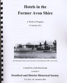
Book, Barraclough, Linda, Hotels in the former Avon Shire: A Work in Progress, 2011
Published book (processed, comb bound) "Hotels in the former Avon Shire: A Work in Progress". 47 pages, illus., A4, Edition May 2012. Includes hotels at Stratford, Nuntin, Delvine, Munro, Stockdale, Cobbanah, Dargo, Grant, Iguana Creek. -
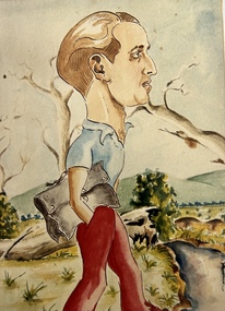 Tatura Irrigation & Wartime Camps Museum
Photograph - Photograph of Painting, Self Portrait George Rosenkranz, 1945
Colour photograph of a self portrait of George Rosenkranz, Graytown camp 1945. Brown hair, blue shirt, red trousers, hand in pocket. Holding a grey satchel bag. Rolling hills in background. Trees, plants and creek right hand bottom.internees, george rosenkranz, graytown victoria -
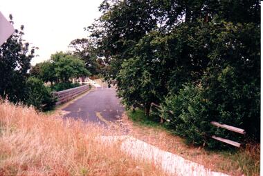 Hume City Civic Collection
Photograph, c 1980s
The stone bridge was the only entry into Sunbury on the eastern side of the town and was in use until the road was re-routed and widened in the 1970s.A coloured photograph of the roadway over the Macedon Street bridge which spans Jacksons Creek. There is a grassy area in the foreground with trees growing either side of the bridge. The narrow asphalted surface of the road across the bridge is cut off by a low stone wall.stone bridges, jacksons creek, macedon street road bridge, george evans collection -
 Hume City Civic Collection
Photograph, early 1980s
The photograph shows the extent of Sunbury's development to the west of the town in the early 1980s. The settlement at this stage extended along either side of Gap Road for about 0.5 km beyond Elizabeth Drive.A coloured landscape photograph with rounded corners taken from Mt. Holden and looking towards the expanding town of Sunbury. The Melba Avenue drain which flows into Blind Creek is in the foreground. Sheoak Hill, the site of the former Sunbury Asylum is in the middle of the skyline.sunbury township, reservoir road, mt. holden, sunbury asylum, george evans collection -
 Sunshine and District Historical Society Incorporated
Map (1967), CITY OF SUNSHINE, June 1967, 1967
The City of Sunshine no longer exists. Part of the eastern area has been annexed by the City of Maribyrnong, and the rest of the old City of Sunshine has been amalgamated with the City of Keilor to form the larger City of Brimbank.This 1967 map is a historical record of the City of Sunshine as it existed 27 years before the amalgamation of Councils, and the creation of the City of Brimbank in 1994.Whitish paper map with black printing that is laminated in clear plastic film, and has a wood slat attached to the top edge. The June 1967 map is of the previous CITY OF SUNSHINE showing City and Parish boundaries, streets, railways, creeks, river etc.Purple ink stamps at top left hand and right hand areas showing address and contact details of 'Sunshine Industrial Promotion Centre.'city of sunshine, june 1967, map, city, parish, boundaries, brimbank -
Stawell Historical Society Inc
Accessory - Jewellery
1930's Collection of seven items of costume dress jewelry belonging to Mary and Margaret Devery of Greens Creek Two bracelets, two clips for Dresses or Shoes,. Jewelry Accessory (part), Hair Coombe and Flower Broach in two cardboard boxes.clothing -
Whitehorse Historical Society Inc.
Map, Dandenong Ranges area. Sheet 7, c1957
Detailed map covering area from Mitcham and Vermont to Ringwood and Heathmont.Detailed map covering area from Mitcham and Vermont to Ringwood and Heathmont. Shows streets, block boundaries, buildings, railway and creeks. Note says prepared from State Aerial Survey, April 1954 and Cadastrial Survey information July 1956.Detailed map covering area from Mitcham and Vermont to Ringwood and Heathmont. maps, mitcham, vermont, ringwood, heathmont -
 Southern Sherbrooke Historical Society Inc.
Photograph - Menzies Creek Hall damaged by storm, 2016
Colour photographs of Menzies Creek Hall damaged by a falling tree during a wind storm, 10th October 2016. In the first photo several cut logs in the foreground. The second photo shows a room bisected by the tree. Photos taken by Marian Matta. -
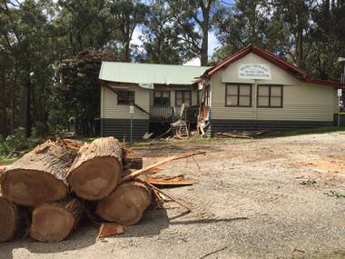
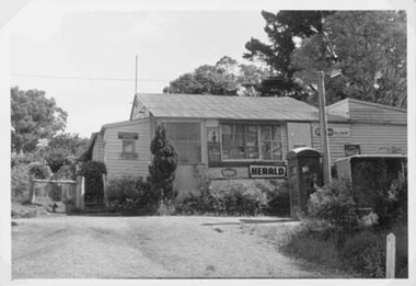 Southern Sherbrooke Historical Society Inc.
Photograph - Menzies Creek Post Office, 1968
Photograph of Menzies Creek Post Office and General Store on the Belgrave-Gembrook Rd. Shows narrow flight of stairs to doorway. In front of store is a telephone box and a bus shelter, Many trees visible in background. Photo from National Archives of Australia. -
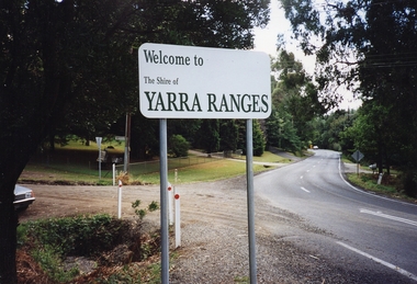 Southern Sherbrooke Historical Society Inc.
Photograph - Photo, temporary shire sign. Shire of Yarra Ranges
Colour photograph of entrance to Menzies Creek looking west, showing the new temporary Shire sign after amalgamation of Victoria's council areas in 1995. Belgrave-Gembrook Rd with Menzies Rd going to the left. Photo taken in 1995 by Marian Matta. -
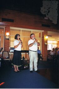 Bendigo Historical Society Inc.
Photograph - PETER ELLIS COLLECTION: EMU CREEK BUSH BAND, 25th November, 2007
Colour photograph. Emu Creek Bush Band playing in hall. Blue carpet. Marg Hogan and Peter Ellis playing recorder. Back of photo reads: Bendigo Retirement Village Sunday Nov. 25th 2007 Margaret Hogan Peter Ellis.entertainment, music, emu creek bush band