Showing 27535 items
matching yarra-river
-
 Lakes Entrance Regional Historical Society (operating as Lakes Entrance History Centre & Museum)
Photograph, Rev John Flynn, 1906
Photographic proof on light cardBlack and white photograph of views of Snowy River Gorge at Tulock Ard Gelantipy VictoriaJohyn Flynn Postcards from Buchan P39waterways -
Lakes Entrance Regional Historical Society (operating as Lakes Entrance History Centre & Museum)
Postcard, VSM Series, 1900 c
Coloured postcard of SS Despatch leaving the Bairnsdale wharf on Mitchell River Bairnsdale VictoriaSS Despatch leaving Bairnsdale Wharfships and shipping, waterways, dredging -
 Wangaratta Art Gallery
Painting, John Colin Angus, Ratray's Store and Punt - Crossing the Ovens - 1839, 1963
Rural City of Wangaratta CollectionA landscape of a river crossing painted in oil using shades of green, brown, blue, and white.J. Colin Angus/ (bottom right corner)wangaratta art gallery, j colin angus, john colin angus, landscape painting -
 Ballarat Heritage Services
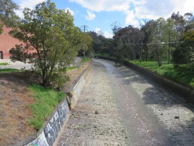
Photograph, Bluestone Channel near Sunnyside Mill, Ballarat, 04/09/2022
Bluestone Channel near Sunnyside Mill, Ballarat. The Channel holds the Yarrowee River, Ballarat.yarrowee river, yarrowee creek, sunnyside corner, channel, bluestone -
 Lakes Entrance Regional Historical Society (operating as Lakes Entrance History Centre & Museum)
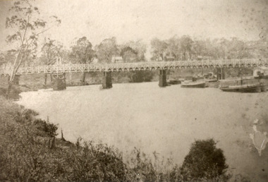
Photograph, Bulmer, H D, 1887
Black and white photograph of the first road bridge over the Mitchell River at Bairnsdale, Victoria.township, waterways -
 Lakes Entrance Regional Historical Society (operating as Lakes Entrance History Centre & Museum)
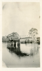
Photograph, Jemmeson, Edie, 1925
Also photograph of the bridge closed 7 x 11.5Black and white photograph of the swing bridge open over the Latrobe River at Longford, Victoria.bridges, waterways, jetties -
Lakes Entrance Regional Historical Society (operating as Lakes Entrance History Centre & Museum)
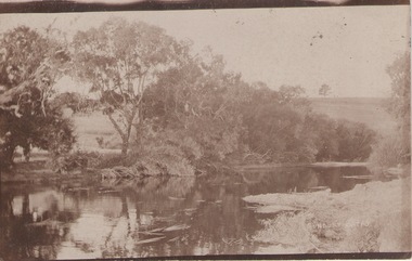
Photograph, G Legg Bairnsdale, `1970 1980 c
This narrow waterway was the original steamer route to the Port of MossifaceBlack and white photograph of the Tambo River adjoining Arthur Howletts property at Mossiface Victoriaboats and boating, waterways -
Lakes Entrance Regional Historical Society (operating as Lakes Entrance History Centre & Museum)
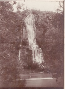
Photograph, Bess Larkins, 1980 c
Colour photograph of the Little River Falls in full spate at Wulgulmerang near Buchan Victoriaenvironment, parks -
Lakes Entrance Regional Historical Society (operating as Lakes Entrance History Centre & Museum)
Photograph, Keith Scarce, 1979
Colour photograph showing glimpses of the Snowy River in the Alpine Country East Gippsland Victoriaparks -
Lakes Entrance Regional Historical Society (operating as Lakes Entrance History Centre & Museum)
Photograph
Colour photograph of Mitchell River at entrance to silt jetties near Eagle Point Victoriahistoric buildings, waterways -
Lakes Entrance Regional Historical Society (operating as Lakes Entrance History Centre & Museum)
Photograph
Also 02072Black and white photograph of SS Bellbird after its launch on Tambo River at Johnsonvillehouses, guesthouses, tourism -
 Kew Historical Society Inc
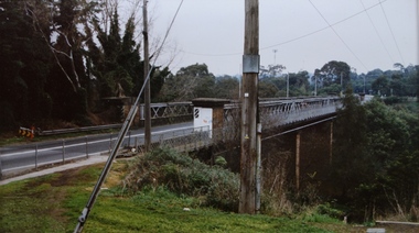
Photograph - Chandler Highway Bridge, Stewart West, 2001
Colour photograph by Stuart West of the Chandler Highway Bridge from the Fairfield side of the River.Nilchandler highway bridge, stewart west -
 City of Warrnambool Rowing Club
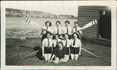
Photograph
The photograph is believed to be taken in 1936. The rowers are young women- so this may be a school crew.Black and white photograph of 9 rowers and 2 oars on the banks of the Hopkins River, Warrnambool.No names given. -
 City of Warrnambool Rowing Club
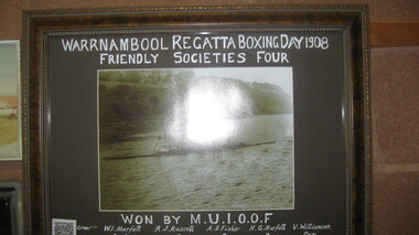
Black and white photograph, Warrnambool Regatta Boxing Day 1908
Won by M.U.I.O.O.F. Crew: W. Marfett stroke, R.J. Russell 3, A.J. Fisher 2, H.G. Marfell bow, V. Williamson cox. “As its name suggests, Manchester Unity Independent Order of Oddfellows (MUIOOF) had its origins in Manchester, England. It was established in Melbourne in 1840 when Augustus Greeves, a member of the MUIOOF in England, migrated to Australia. On his arrival in Melbourne, Greeves teamed up with journalist Thomas Strode, to form the first lodge—The Australia Felix Lodge. The lodge received its Constitution on 7 December 1840 and this is recognised as the birth date of Manchester Unity in Victoria.” Warrnambool rowing club was founded in 1973, with regattas starting in 1885 and a VRA regatta in 1890. Timber framed black and white photograph of a mens rowing crew on the hopkins river, warrnambool.Warrnambool Regatta Boxing Day 1908 Friendly Society's Four Won by: M.U.I.O.O.F.rowing, city of warrnambool rowing club, warrnambool rowing club, hopkins river warrnambool, warrnambool regatta, 1908, 1908 -
 Brimbank City Council Art Collection
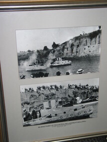
Photograph, Re-enactment of the Gallipoli Landings, 1919 (original)
Photographic re-enactment of the Gallipoli Landings , staged at Saltwater River Anzac Day 1919inscription along bottom of picture -
 Sunbury Family History and Heritage Society Inc.
Photograph, c1920s
The waterfall is cascading down the Johnson Cliff which is on the Jacksons Creek downstream from Sunbury town.A sepia photograph with a narrow cream border mounted on cardboard of a waterfall cascading into the river below. johnsons cliff, jacksons creek, waterfalls -
 Sunbury Family History and Heritage Society Inc.
Photograph, SUNBURY BATHS
The scene featured on the post card is a view of The Nook on the Jacksons Creek. For many years before the Aquatic Centre was build in the town, The Nook was the swimming place for local residents. The surrounding area had seats and change rooms. The Sunbury Swimming club was established at this site before the Aquatic Centre was built.A sepia photograph in post card format of river bend and small sandy beach on the bank.the nook, swimming -
 Wodonga & District Historical Society Inc
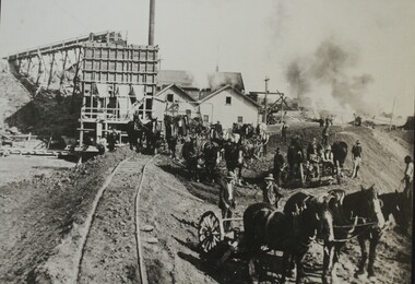
Photograph - Constructing the Hume Weir, c1928
This image is from Wodonga Historical Society's large collection of photographs documenting the construction of the Hume Dam during its initial construction and ongoing development. Hume Dam took 17 years to construct from the turning of the first sod on 28 November 1919 by Sir Ronald Munro-Ferguson, Governor-General of Australia. The first filling was in December 1934 and it was officially opened on 21 November 1936. Between 1950 and 1961 further modifications were made which enlarged its storage capacity. Progressive improvements have been made since that time to ensure the dam meets modern safety standards.This photo reflects a major stage in the construction of the Hume Dam.A large black and white image of construction of the Hume Weir on the Murray River mounted on board.hume dam construction, hume weir australia -
 National Wool Museum
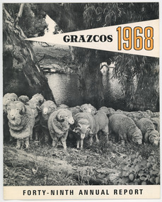
Document - Grazcos Annual Report, Grazcos Co-operative Limited, 1968
The co-operative was registered in 1919 as the Graziers Co-op Shearing Company Limited. It changed its name in September 1948 to Grazcos Co-operative Ltd. In 1981 the co-operative merged with Farmers & Graziers Co-op Ltd to form Farmers Grazcos Co-op Ltd. This item is part of a collection of Annual Reports from Grazcos dated from 1949 - 1980.Booklet featuring black and white image of sheep with river in background, and black and yellow text. front: GRAZCOS / 1968 / FORTY-NINTH ANNUAL REPORTagricultural co-operative, agricultural wholesaling, annual reports, rural life, rural industry, business, corporate body -
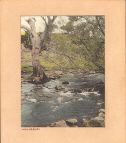 Bendigo Historical Society Inc.
Photograph - STREAM AT MALMSBURY
Photograph, hand tinted. Stream at Malmsbury (Coliban River). History: with note 'Photographs from Mrs Ella Bourke, 131 Barnard St, Bendigo, ph 438269'. Photographs Francis (Frank) Thomas Kennedy'. James Lerk 'Coliban River'??Francil (Frank) Thomas Kennedyplace, landscape view, see also 2001.152.01, 2001.153.01, 2001.154.01, 2001.157.01, 2001.158.01, 2001.159.01, 2001.160.01, 2001.162.01 -
 Eltham District Historical Society Inc
Document - Folder, Victoria Archaeological Survey, 1982-1990
sites, structures, archaeological significance, victoria archaeological survey -
 Kew Historical Society Inc
Map, MMBW, MMBW Plan No.64 Kew & Heidelberg, 1900-1910
The Melbourne and Metropolitan Board of Works (MMBW) was established by an act of the Victorian Parliament in 1890 to prepare for and to implement a sewerage and water reticulation system across what was then inner Melbourne, its surrounding and middle distance suburbs, including Kew. The MMBW was disbanded in 1991.The map collection of the Kew Historical Society has at its core the historic maps assembled and originally stored in the City Engineer's Department of the City of Kew. These include maps in a number of scales. The vast majority of maps were produced by the MMBW in the first two decades of the twentieth century, and are solid working maps, backed by linen for durability. These maps are historically significant to Kew, the City of Boroondara and to the history of the development of state utilities in Victoria. A number of the Kew maps have additional details added by former municipal officers, including the levels reached by various floods. As these were working documents, information was added to them long after the period of their initial production and distribution.Early map of part of the Borough of Kew, created in the first decade of the twentieth century, at a scale 160 ft to 1 inch. The map covers what was then the northern most part of Kew, bordered on its north and west by the Yarra River, in the East by Connor's Creek and by the Asylum in the south. The map shows the extent of urban development by that time, prominent institutions and the outlines of built structures in the municipality. Contour lines and historic flood levels were added in ink to the map at a later stage.MELBOURNE AND METROPOLITAN BOARD OF WORKS / PLAN NO. 64 / KEW & HEIDELBERGmelbourne & metropolitan board of works, mmbw maps, mmbw plans, borough of kew, cartography -
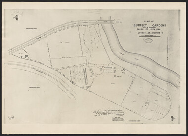 University of Melbourne, Burnley Campus Archives
Photograph - Plan of Burnley Gardens
"This plan is a copy of a copy of the survey made by Mr. Turner in 1926. The original plan and field notes are missing _ file Rs 3529" Signed by _signature unreadable_ -
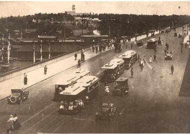 Melbourne Tram Museum
Photograph - Photograph Card, Kelly Collection, View Productions, Princes Bridge / Batman Ave tram terminus, Photo c1920
Photograph Card - folded card, blank inside of Cable Trams, motor cars, pedestrians crossing Princes Bridge over the Yarra River with the Princes Bridge / Batman Ave tram terminus with a shelter in the background. Shows five cable tram sets. Has railway signals and Government House in the view. Produced by View Productions GPO Box 1858 Sydney, from the Kelly Collection, titled "On the Princes Bridge, circa 1920, Melbourne, Victoria, Australia". Has the Publishers logo on the rear.trams, tramways, princes bridge, batman ave, swanston st, cable trams, shelters -
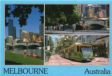 Melbourne Tram Museum
Postcard, Bartel Postcards, three photos of Melbourne scenes, early 1990's
Colour postcard 3 photo panels, blue border, divided back - Bartel Postcards: 1 - View of Melbourne over the Yarra River 2 - Princes Bridge 3 - B2 2013 in Bourke St, East Brunswick, Route 96 Back has space for name and address, stamp and a message and details of the postcard. Produced by Bartel Postcards possibly early 1990's Card No. BG318 Has "Melbourne Australia" along the bottom edge. Two copies held.trams, tramways, bourke st, mall, b class, tram 2013 -
Port Melbourne Historical & Preservation Society
Letter - Between Chief Secretary's office and Town Clerk, Sandridge re new bridge across Yarra, 10 Dec 1978
Correspondence between Chief Secretary's office and Sandridge Town Clerk re new Bridge across Yarra 1878 (one of two letters)engineering - bridges, edward clark, town clerks -
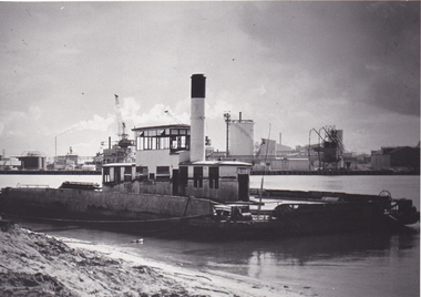 Port Melbourne Historical & Preservation Society
Photograph - Williamstown 'Short' Road ferry, laying at south side of the Yarra prior to being broken up, 1970s
Black and white photographic copy from slide of Short Road Ferry laying at south side of Yarra, prior to being broken uptransport - ferries -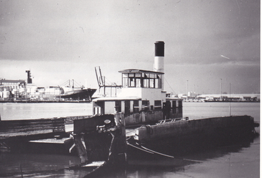
Tatura Irrigation & Wartime Camps Museum
Book, A Handbook for Enthusiasts - Local History, 1985
Showing how to find information on researcing and writing history in Country and Municipal areasBlue hard cover, dust cover wrap around. Illustration of Yarra St., Geelong 1872 by A Webb. Collection Geelong Art GalleryFord 1987research, reference