Showing 11916 items matching " vic"
-
 Halls Gap & Grampians Historical Society
Newspaper - B/W
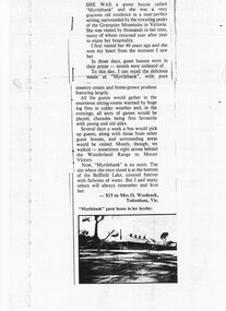
She was a guest house called "Myrtlebank" and she was a very gracious old residence in a near perfect setting, surrounded by the towering peaks of the Grampian Mountains in Victoria. She was visited by thousands in her time, many of whom returned year after year to enjoy her hospitality. I first visited her 40 years ago and she won my heart from the moment I saw her. In those days, guest houses were in their prime - motels were unheard of. To this day, I can recall the delicious meals at "Myrtlebank" with pure country cream and home grown produce featuring largely. All the guests would gather in the enormous sitting rooms warmed by huge log fires in colder weather and , in the evenings, all sorts of games would be played, charades being first favourite with young and old alike. Several days a week a bus would pick up guests, along with those from other guest houses, and surrounding areas would be visited. Mostly, though, we walked - sometimes right across behind the Wonderland Range to Mount Victory. Now, "Myrtlebank" is no more. The site where she once stood is at the bottom of the Bellfield Lake, covered forever with fathoms of water. But I and many others will always remember and love her. Letter to paper with photograph of MyrtlebankSubmitted by Mrs O. Woolcock, Tottenham Vic who won $15 prize describing accomodation for guests at Myrtlebankaccommodation, guesthouses, myrtlebank -
 Halls Gap & Grampians Historical Society
Photograph - B/W
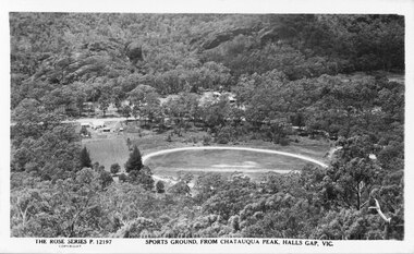
This is a postcard of the sports ground in Halls Gap, taken from Chatauqua Peak. It is No. 12197 in the Rose Series of postcards.The photo shows a round clearing (sports ground), seen from above, in the midst of bush. There are some bare strips in the middle of the field and a track around its perimeter. Some buildings are visible to the left of the field and a road runs behind it. There are more buildings just visible through the bush in the centre, on the far side of the road."The Rose Series P. 12197, Sports Ground, from Chatauqua Peak, Halls Gap, Vic" on bottom of postcard.recreation, sport -
 Bendigo Historical Society Inc.
Clothing - AILEEN AND JOHN ELLISON COLLECTION: BENDIGO HIGH SCHOOL JUMPER BY POLWARTH, 1960's
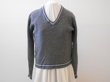
Grey long sleeved woollen school jumper. V neck with four coloured stripes on ribbed band. 7 cm ribbed cuffs and band at bottom of jumper - all with four coloured stripes. Stripes - Royal Blue, yellow, pale blue,, royal blue ... Part of Bendigo High School Uniform.Label inside back neck. 'School and College wear 80% wool 20% nylon. By Polwarth Prahan Vic.costume, female, bendigo high scool jumper -
 Healesville Sanctuary Heritage Centre
Envelope with stamps - commemorating 50th anniversary of the breeding of platypus "Corrie"
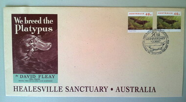
The first platypus to be bred in captivity was at the Sir Colin MacKenzie Sanctuary (now known as Healesville Sanctuary) in 1943. The birth was mainly thanks to the efforts of David Howells Fleay who was the director of the Sanctuary at that time. It was approx 50 years until another was born in captivity. In 1998 another was bred at Healesville Sanctuary. Since then attempts at breeding platypus have been largely unsuccessful.This DL envelope was used at the time of the 50th anniversary of the first breeding of a platypus in captivity. The envelope is pale yellow with brown wording and a brown and green image of David Fleay's book, "We breed the Platypus". There are 2 Australian 40 cent stamps on the envelope, featuring a swimming platypus and it has been franked with a circular stamp depicting "Corrie" the platypus. On the back of the envelope in brown wording is some general information about the platypus and also details of the first breeding . Franking: HEALESVILLE VIC 3777 25th FEBRUARY 1994 FIRST PLATYPUS BRED IN CAPTIVITY / 50th ANNIVERSARY / "CORRIE"/stationery, envelope, healesville-sanctuary, platypus, first-breeding, anniversary, fleay -
 St Kilda Historical Society
Photograph - Photo map, 08/02/1966
One of a series of photo-maps produced for the Department of Crown Lands and Survey (1857-1983). For correlation with a current map, and access to other historical photo maps of Victoria, see the Historic Photo-Maps Index published by the Department of Environment, Land, Water and Planning at https://services.land.vic.gov.au/DELWPmaps/historical-photomaps/Black and white aerial photographVic 1916 Melbourne 1966 Project Run 13 E 8.2.66 Lens 122 151.75MM 9.800 113st kilda, st kilda marina, st kilda beach, point ormond, elwood, elwood beach, elwood park, 1966 -
 St Kilda Historical Society
Photograph - Photo map, 08/02/1966
One of a series of photo-maps produced for the Department of Crown Lands and Survey (1857-1983). For correlation with a current map, and access to other historical photo maps of Victoria, see the Historic Photo-Maps Index published by the Department of Environment, Land, Water and Planning at https://services.land.vic.gov.au/DELWPmaps/historical-photomaps/Black and white aerial photographVic 1916 Melbourne 1966 Project Run 13 E 8.2.66 Lens 122 151.75MM 9.800 111st kilda, balaclava, caulfield, caulfield north, st kilda east, elsternwick, elsterwick park, elwood park, elwood canal, elwood beach, ripponlea, 1966 -
 St Kilda Historical Society
Photograph - Photo map, 11/01/1968
One of a series of photo-maps produced for the Department of Crown Lands and Survey (1857-1983). For correlation with a current map, and access to other historical photo maps of Victoria, see the Historic Photo-Maps Index published by the Department of Environment, Land, Water and Planning at https://services.land.vic.gov.au/DELWPmaps/historical-photomaps/Black and white aerial photographVic 2132 State Aerial Survey Melbourne 1968 Proj Run 27E 11.1.68 5100 ASL 65caulfield north, caulfield park, armadale, malvern, 1968 -
 St Kilda Historical Society
Photograph - Photo map, 11/01/1968
One of a series of photo-maps produced for the Department of Crown Lands and Survey (1857-1983). For correlation with a current map, and access to other historical photo maps of Victoria, see the Historic Photo-Maps Index published by the Department of Environment, Land, Water and Planning at https://services.land.vic.gov.au/DELWPmaps/historical-photomaps/Black and white aerial photographVic 2132 State Aerial Survey Melbourne 1968 Proj Run 27E 11.1.68 5100 ASL 67st kilda east, st kilda cemetery, caulfield north, alma park, balaclava, armadale, 1968 -
 St Kilda Historical Society
Photograph - Photo map, 11/01/1968
One of a series of photo-maps produced for the Department of Crown Lands and Survey (1857-1983). For correlation with a current map, and access to other historical photo maps of Victoria, see the Historic Photo-Maps Index published by the Department of Environment, Land, Water and Planning at https://services.land.vic.gov.au/DELWPmaps/historical-photomaps/Black and white aerial photographVic 2132 State Aerial Survey Melbourne 1968 Proj. Run 27E 11.1.68 5100 ASL 69st kilda, albert park, st kilda east, st kilda beach, alma park, windsor, prahran, 1968 -
 St Kilda Historical Society
Photograph - Photo map, 11/01/1968
One of a series of photo-maps produced for the Department of Crown Lands and Survey (1857-1983). For correlation with a current map, and access to other historical photo maps of Victoria, see the Historic Photo-Maps Index published by the Department of Environment, Land, Water and Planning at https://services.land.vic.gov.au/DELWPmaps/historical-photomaps/Black and white aerial photographVic 2132 State Aerial Survey Melbourne 1968 Proj. Run 28E 11.1.68 5100 ASL 81st kilda, balaclava, st kilda east, ripponlea, elwood, elsternwick, caulfield, st kilda botanical gardens, 1968 -
 St Kilda Historical Society
Photograph - Photo map, 11/01/1968
One of a series of photo-maps produced for the Department of Crown Lands and Survey (1857-1983). For correlation with a current map, and access to other historical photo maps of Victoria, see the Historic Photo-Maps Index published by the Department of Environment, Land, Water and Planning at https://services.land.vic.gov.au/DELWPmaps/historical-photomaps/Black and white aerial photographVic 2132 State Aerial Survey Melbourne 1968 Proj. Run 29E 11.1.68 5100 ASL 194elwood, elwood beach, elwood park, elsternwick park, ripponlea, elwood canal, balaclava, st kilda, 1968 -
 St Kilda Historical Society
Photograph - Photo map, 11/01/1968
One of a series of photo-maps produced for the Department of Crown Lands and Survey (1857-1983). For correlation with a current map, and access to other historical photo maps of Victoria, see the Historic Photo-Maps Index published by the Department of Environment, Land, Water and Planning at https://services.land.vic.gov.au/DELWPmaps/historical-photomaps/Black and white aerial photographVic 2132 State Aerial Survey Melbourne 1968 Proj. Run 29E 11.1.68 5100 ASL 196elwood, elwood park, elwood canal, elwood beach, st kilda marina, mc moran reserve, point ormond, 1968 -
![Invitation, [Squatter]](/media/collectors/510b3f7f023fd725b4cd52cc/items/54065f589821f50e3cc9f4ca/item-media/54065f589821f50e3cc9f4cb/item-fit-380x285.jpg) National Wool Museum
National Wool MuseumInvitation, [Squatter]
Associated documents from Mr R Lloyd provide further informationMs Elizabeth Triarico/ Curator/ National wool Museum/ Cnr Moorabool/ Brougham Streets/ Geelong VIC 3220sheep stations - management wool growing squatters, lloyd, mr robert, australia, sheep stations - management, wool growing, squatters -
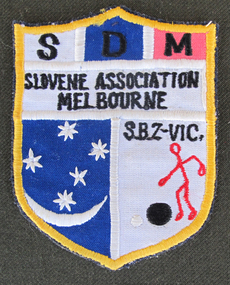 Slovenian Association Melbourne
Embroidered emblem, Slovenian Bocce Association Emblem, not known
Emblem of the Slovenian Bocce Association of Slovenian Association Melbourne, being a part of Slovenian Bocce Association of Victoria, worn by the competitors for the Victorian, interstate and overseas competitions.SDM - Slovenian Association Melbourne S:B:Z: - VIC. - Slovenska balinarska zveza Viktorije - Slovenian Bocce Association Victoriaemblem, slovenian association melbourne, bocce -
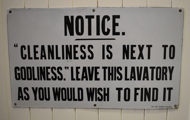 National Wool Museum
Sign - Notice, Victorian Enamelling Works
Sign used at Foster Valley Mill.Metal enamel toilet sign with black lettering on a white background.NOTICE. / "CLEANLINESS IS NEXT TO / GODLINESS." LEAVE / THIS LAVATORY / AS YOU WOULD WISH TO FIND IT / VIC. ENL. WORKS GEELONG.valley worsted mill, foster valley mill pty ltd, sign, toilets, notice, manufacturing, factories, textile industry, workplace -
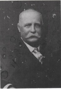 Rutherglen Historical Society
Image, c 1900
Black and white portrait photograph of a man with a white moustache.On back of photo: "Frederick William Burgoyne | B 1843 - Plymouth, Devon, Eng. | D 1917 Runnymede, Vic."frederick william burgoyne, burgoyne family -
 Unions Ballarat
Good company (Don Woodward Collection), Gullett, Henry "Jo", 1992
An autobiography of Jo Gullett who was a journalist, politician and horseman. The book is set in Paris, Oxford, Canberra, NSW and during WWII.Politics, war and media.Book; 310 pages.Black ink, "Mary O'Dea, RMB 8865, Bochara Vic 3301. From Paul and Sue - Christmas 1991."btlc, ballarat trades hall, ballarat trades and labour council, politics and government, warfare, animals, military, media - australia -
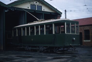 Ballarat Tramway Museum
Slide - 35mm slide/s, 11/12/1954 12:00:00 AM
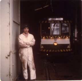
Bendigo scrubber car, photographed at tram depot, 11-12-1954. Has a person in the driving position. Under exposed. Photo by Keith Kings?.'11-12-54, XEY, K/WJU-55, 1/25, f3.5, Bendigo Vic' in blue ink.tramways, trams, bendigo, scrubber tram, scrubber -
 Ballarat Tramway Museum
Photograph - Colour Print, Lilian Butler, Sep. 1971
Possibly has a strong association with Mr Wayne Kell, a SEC Ballarat depot worker.Colour print of a worker (Mr Wayne Kell?) standing by one of the depot doors with tram 32 in the background. The photo of Mr. Kell in Reg Item 1861, shows him with long hair - likely to be the same person - see also 6450 where he has a large cap on. See also Reg Item 6544i2 for a colour slide of this photograph. Item was placed in an envelope marked "Mr Wayne Kell" - retained with photograph in storage folder. Photo printed on Kodak Paper. Photograph by Lilian Butler?in ink on rear "Tram Depot - Wendouree Parade, Ballarat Vic, September 1971, with my compliments Lilian Butlertrams, tramways, sec, depot, personnel, tram 32 -
 Ballarat Tramway Museum
Photograph - Colour Print, Lilian Butler, Aug. 1971
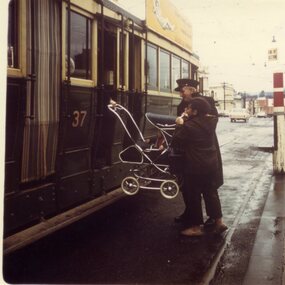
Yields information about the loading of prams onto the SEC trams by crews and passengers.Colour print of a group of a SEC driver or conductor assisting a passenger to load a pram onto No. 37 at the corner of Sturt and Lydiard St, Ballarat. Has the tram stop section short pole on the right hand side. Photo printed on Kodak Paper. Photograph by Lilian Butler?in ink on rear "August 1971, Cnr Sturt and Lydiard Sts, Ballarat Vic. With my compliments Lilian Butler".trams, tramways, prams, passengers, sturt st, lydiard st, tram stops, sections, poles -
 Kew Historical Society Inc
Photograph, Marnie McLeod, Floods on the River Yarra at Kew, 1916
The donation was accompanied by the following letter from the donor: "Hi. I found these in with family photos. Taken by family as Mamie McLeod was living in Fellows Street, Kew, so would be near there. Retain (or discard) as you see fit." [Donor's name and address withheld from public view]. To gain an insight into the flood levels at Kew, it is worth reading newspaper accounts of the event. The Age published an article - Valuable Gardens Destroyed at Kew - on 25 September 1916: "VALUABLE GARDENS DESTROYED AT KEW. From the heights of Studley Park, Kew, a splendid view of the flood waters can be obtained, and yesterday afternoon, despite continuous rain, crowds of citizens assembled there to witness the spectacle. There is a vast stretch of water some 300 or 400 yards broad, above the foot bridge connecting Gipps-street, Collingwood, and Studley Park. The river is only about 3 feet from the top of the embankment connecting with the ramp of the bridge on the Studiey Park side. When the upper llood waters come down it is almost a certainty that tne embankment will be submerged and the bridge rendered impassible. Below the bridge the waters again stretch out, and have submerged all the low-lying land on the Collingwood side and invaded the back premises ot the Kodak Co., Phoenix Biscuit Factory, a tannery adjoining thereto, the Shamrock Brewery, and Chinese gardens in the vicinity. At Walmer-street-bridge, at the end of Studley Park, the low-lying land on the Kew side is covered with water to the depth of many feet. Tlie land in question is owned in a great part by Mr Frank Lavers who haa gone in for intense culture on a pretty liberal scale on both the slopes of the hill and on the river flat. On the latter he is cultivating many acres of asparagus, and has at a considerable cost spent three years in preparing the ground and installing an irrigation system, reticulated from the Yan Yean water supply. This year the asparagus was put down, and the plants were in a promising condition. Tlie flood waters are now flowing fast over the land. The crop is ruined, and three years' work and expenditure destroyed. Mr. Laver's private residence fortunately is high above flood level, but two houses he owns off Young-street have been flooded out. Having been warned in time, the tenants removed their furniture hefore the water came down to Mr. Laver's residence, where they themselves have been given accommodation in the meantime. All the river flats in East Kew are under water. One or two low-lying houses have been flooded. Chipperfield's boat shed at Willsmere is nearly covered, and some Chinese gardens in the vicinity are several feet under water."This, and the other three photographs donated of floods in Kew are believed to be the earliest in the collection. Together with our original MMBW River Yarra map showing flood levels, these items, when compared allow researchers to gain a visual perspective of the extent of the flood in 1916. Panoramic view, believed to be looking north towards Fairfield from the Zig-Zag Bridge on the River Yarra. The inscription on the reverese identifies it as taken before 1920.Inscription on reverse in ink "(pre 1920) Flood from Zig-zag bridge Yarra River, Kew Vic."river yarra, kew, floods 1916, zig-zag bridge -
 Kew Historical Society Inc
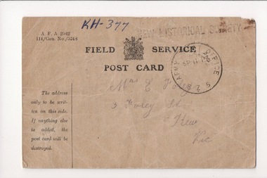
Postcard - Postcard [and Envelope], James Foley, Field Service Postcard from James Leonard Foley, 1915, 1915
James Leonard Foley’s family lived at ‘Warringal’, 3 Foley Street, Kew. Like many other soldiers from Kew, he was educated at the Kew State School. He enlisted at the age of 19 in March 1915. His previous occupation is recorded as 'Blacksmith'. James sent a postcard to his mother in 1915 saying that he was ‘quite well’. He was to be killed in action on the Western Front on 24 August 1916 and is buried in the Villers-Bretonneux cemetery. Poignant card from a Kew soldier in World War 1 who was later to die on the Western Front.Single page Field Service Postcard and Envelope from James Leonard Foley to Mrs Eliza Foley of 3 Foley Street in Kew. Private J.L. Foley (1600) served during World War one with the 24th Battalion. He died on the Western Front. His parents were Edward and Eliza Foley of 3 Foley Street, Kew.Mrs E Foley, 3 Foley Street, Kew, Vic [Signed] JL Foley 8/9/15first world war (1914-18), james foley, world war one, foley street, warringal, villers-bretonneux cemetery, e. foley, edward foley -
 Ringwood RSL Sub-Branch
Equipment
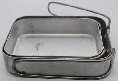
Two Aluminium mess tin with two metal clips7350-66-014-5895 SMP over Vic arrow 5/82 Nick scratched on bottom of tin -
 Bendigo Historical Society Inc.
Postcard - Alice McGregor Postcard Collection, 1900 - 1920
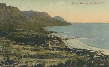
Alice McGREGOR Born: 1908; unknown parents. Possibly adopted by the Salter family? Electoral Roll 1936: Highland Terrace Kangaroo Flat. Alice Mary Salter and William Robert Salter living together; presumed to be sister and brother. William Robert Salter was killed in a MVA in Bendigo in 1937 aged 26. In Victoria in 1938, Alice Mary Salter married James Thomas McGregor (born Victoria 1917, died Victoria 1983, buried Fawkner Cemetery) Lived: 1968; 22 Wade Street Golden Square Alice McGregor Died: 1999 aged 91 at Anne Caudle Centre, Bendigo Buried: Kangaroo Flat Cemetery See additional research. Postcard Album of Alice McGregor contained 86 post cards.Postcard Album of Alice McGregor containing 86 postcards. See 1400 Colour photo of Camps Bay and Apostles, C.P., South Africa Small township on the bay. Addressee - Mrs. Gray, Vermont, Vic Sender - E. Branson Stamp dated 9 Dec 1919, Melbourne postcard, collector, alice mcgregor -
Lakes Entrance Historical Society
Book, Australian War Memorial Canberra, 1950
A guide to the galleries at the Australian War Memorial, Canberra, 1951.Signatures of many National Service personnel, including Sig Holding, T.E. 2 Au Bd Squ Vic.memorials, directories -
 Whitehorse Historical Society Inc.
Pamphlet - Catalogue
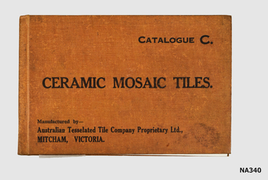
Catalogue of 28 examples of Tiles made by Australian Tesselated Tile Co.Catalogue C. Ceramic Mosaic tiles manufactured by :-Australian Tesselated Tile Co P/L, Mitcham, Vicbooks, catalogues -
 Melbourne Tram Museum
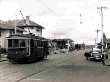
Photograph - Tram 149 Glen Huntly Road, A G Culpeffer-Cooke, 1954
Photo of Q class tram 149, east bound in Glen Huntly Road to Esternwick Railway Station. There is a fire alarm on the far left of the photo and in the overhead a red lens to indicate a tram stop. Photo taken shortly after leaving the Point Ormond tram terminus.Yields information about trams 149 on a Point Ormond service.Black and white print with source stamp on the rear.Has the stamp of "WELT Collection A G Culpeffer-Cooke, Vic Aust ref 8B, Date 1954" on rear.tramways, trams, q class, glen huntly rd, tram 149 -
 Melbourne Tram Museum
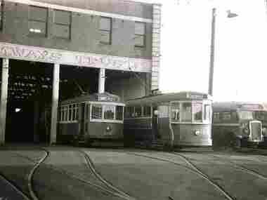
Photograph - Trams 466 and 154 at Footscray Depot, A G Culpeffer-Cooke, 1954
Photo of S class tram 154 and X1 class 466 and a bus outside at the Footscray Bus depot in 1954. Yields information about trams 154 and 466 at Footscray Depot.Black and white print with plain back.Has the stamp of "WELT Collection A G Culpeffer-Cooke, Vic Aust ref 8B, Date 1954" on rear.tramways, trams, s class, t class, tram 466, tram 154, footscray depot, bus -
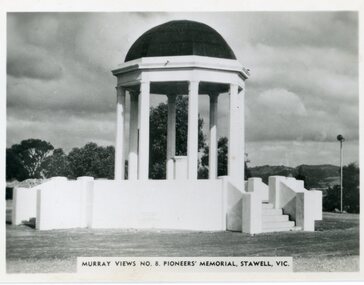 Stawell Historical Society Inc
Postcard, Pioneers’ Memorial on Big Hill
Murray View No. 8. Pioneers’ Memorial photograph showing direction indicators in center of dome installed c 1947 and donated by the Stawell Progress Society. Black and white Murray Views photograph of Pioneers Memorial showing the direction indicator in the center. The direction indicator was given by the Stawell Progress Association in c 1947. Murray Views No. 8. Pioneers' Memorial, Stawell Vic. Rose Seris 12149. Same as Murray Views No 8.stawell -
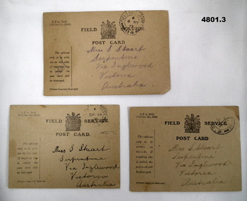 Bendigo Military Museum
Postcard - POSTCARD, FIELD SERVICE, British Army, c.WW2
See Cat 4799 for data. All these 3 cards are addressed to Miss s. Stuart of Serpentine, via Inglewood, Vic, Aust. They are stamped by the "Field Post Office, various dates.These are Army postcards, document NA A.F.A 2042. They have simple messages printed on the rear, of which the sender chooses to use.1. States Rtd letter dated 24/2/17. Signed J Stuart 25.4.19. 2. States he is well - received no letters lately. Signed J Stuart. 3. States he is well - he has received a letter. Signed J Stuart 10.7.17.ww1, aif, family, sister