Showing 27535 items
matching yarra-river
-
![No Mean Destiny: The story of the War Widows Guild of Australia 1945-85 / [by] Mavis Thorpe Clark](/media/collectors/550653872162f11fb04854aa/items/5ece0984f36c2704c4f0cc38/item-media/5ece0a45f36c2704c4f0d882/item-fit-380x285.jpg) Kew Historical Society Inc
Kew Historical Society IncBook, Mavis Thorpe Clark, No Mean Destiny: The story of the War Widows Guild of Australia 1945-85, 1986
History of the War Widows Guild of AustraliaSouth Yarra, Vic. : Hyland House, 1986 xii, 288 p., [36] p. of plates : ill., facsims., ports. ; 25 cm. non-fictionHistory of the War Widows Guild of Australiawar widows -- australia -- societies and clubs -- history., war widows' guild of australia -- history. -
 Canterbury History Group
Document - Railway Communication with Doncaster, Kew and the Kew Asylum and Yarra Bend Asylum Lands, J.Kemp Government Printer, 1908
Report from the Parliamentary Standing Committee on Railways, on the question of Railway Communication with Doncaster, Kew, and the Kew Asylum and Yarra Bend Asylum Lands.canterbury, doncaster, kew, yarra bend asylum, kew asylum, victorian railways, outer circle railway, railways standing committee, victorian government -
 Melbourne Tram Museum
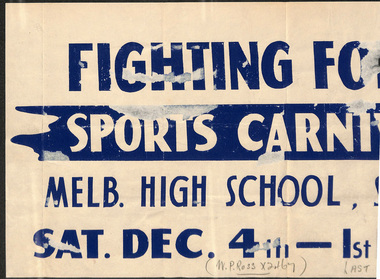
Document - Poster, Melbourne & Metropolitan Tramways Board (MMTB), Fighting Forces Sports Carnival, 1943
Fighting Forces Sports Carnival Melbourne High School, South Yarra Sat 4 Dec 2 pm Poster for front of tram."W.P Ross x2467" and "LAST ...5.30..." written in pencil across bottom.trams, tramways, events, field day, south yarra -
![Scene Near the Buffalo Mountains / [by] Nicholas Caire, circa 1876](/media/collectors/550653872162f11fb04854aa/items/57826074d0cdd1176ce5bcc1/item-media/578260d1d0cdd1176ce5f61a/item-fit-380x285.jpg) Kew Historical Society Inc
Kew Historical Society IncPhotograph, Anglo-Australasian Photographic Company, Scene Near the Buffalo Mountains, c. 1876
Nicholas Caire was born on Guernsey in the Channel Islands in 1837. He arrived in Adelaide with his parents in about 1860. In 1867, following photographic journeys in Gippsland, he opened a studio in Adelaide. From 1870 to 1876 he lived and worked in Talbot in Central Victoria. In 1876 he purchased T. F. Chuck's studios in the Royal Arcade Melbourne. In 1885, following the introduction of dry plate photography, he began a series of landscape series, which were commercially successful. As a photographer, he travelled extensively through Victoria, photographing places few of his contemporaries had previously seen. He died in 1918. Reference: Jack Cato, 'Caire, Nicholas John (1837–1918)', Australian Dictionary of Biography.An original, rare photograph from the series 'Views of Victoria: General Series' by the photographer, Nicholas Caire (1837-1918). The series of 60 photographs that comprise the series was issued c. 1876 and reinforced a neo-Romantic view of the Australian landscape to which a growing nationalist movement would respond. Nicholas Caire was active as a photographer in Australia from 1858 until his death in 1918. His vision of the Australian bush and pioneer life had a counterpart in the works of Henry Lawson and other nationalist poets, authors and painters.‘Scene near the Buffalo Mountains’ : Views of Victoria (General Series) No.41 : Albumen silver photograph | Photo on card with Title and Description on reverse | Mounted 24 x 30 cm; Photo 12 x 17 cm.On Reverse: ‘This scene is taken from the banks of the Buckland River, which is about five miles distant from the Buffalo Mountains, as seen in the distance. These mountains are frequently covered with snow, in consequence of their great altitude. The Buckland River is a small tributary of the Ovens River, which flows through the Beechworth district, and eventually finds its way to the River Murray. The Bridge which is seen on the right of the picture forms the roadway which leads from the Buckland Camp to the Township of Bright.’nicholas caire (1837-1918), landscape photography -
City of Kingston
Photograph - Colour, 1993
Carrum is a suburb in the City of Kingston bordered by the Patterson River in the north and Kananook Creek in the south. To the east the suburb is adjacent to Patterson Lakes. The Carrum Station was opened in 1882, when the railway line from Mordialloc was extended to Frankston. In the early 20th century, it was a destination for holidaymakers occupying tents and cabins. The area now consists of older housing and over time there have been many new housing developments.Carrum is located in the area that was originally part of the Carrum Carrum Swamp. The district had originally been the home of the Bunerong people who fished, gathered food and found refuge in the sand dunes. The Swamp was drained in 1879 when the Patterson Cut was formed and became known as Patterson River. Apart from local farmers, fishermen and hotel-keepers, there were few permanent residents until the early 20th century when it had become popular as a beach resort. In the 1920s and 1930s the area became occupied by more permanent residents.Laminated aerial colour photograph of Carrum and Patterson Lakes in the City of Kingston. The photograph also includes Kananook Creek and the northern section of Seaford. Prominent features include Roy Dore Reserve, Carrum Primary School, Patterson River Secondary College, Keast Park Seaford, the Seaford Swamp Drain and a section of Downs Estate situated on the traditional lands of the Bunurong people.Black type on white adhesive sticker: No. 7140 Black type of white adhesive sticker: 31-1-93 Black handwritten ink (marker): * [an asterisk] Yellow circular adhesive stickerpatterson lakes, seaford, carrum carrum swamp -
 Orbost & District Historical Society
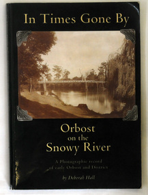
book, In Times Gone By, 2002
The book was written by Deborah Hall in order to preserve the memories of Orbost locals as well as to record its early history. Local history tends to be less documented than other types, with fewer books and artifacts than that of a country or continent. Many local histories are recorded as oral tales or stories and so are more vulnerable than more well known issues. Because it records in a scholarly way the meories of local residents, Deborah Hall's book is a commonly used reference for the early history of Orbost and districtA 158 pp book titled In Times Gone By Orbost on the Snowy River. It is a photographic record of early Orbost and District. It has a dark green coverwith a photograph of the first pile bridge over the Snowy river at Orbost. The book was authored by Deborah Hall.orbost-history reminiscences hall-deborah -
 Bendigo Military Museum
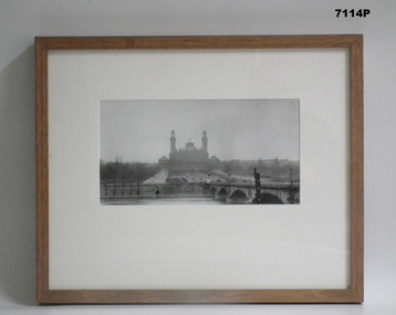
Photograph - PHOTOGRAPH - FRAMED WW1, Wayne Eels, C.2008/2009
The Grinton Collection. “Palais due Trocadero"- built on the hill of Chjaillot, across the Seine from the Eiffel tower, Paris , France. Demolished in 1937. RRefer Cat No 1280 for Jack Grintons service details.Photograph framed. Photograph - black and white photograph on paper, depicting a large building (palace/exhibition space) with formal garden area, river, river wall and bridge in foreground. Frame - timber, light varnish finish, Perspex front, cardboard backing."Group 3: Trip of Lifetime". "A. Palais due Trocadero". framed accessories, camera on the somme, 38th bn, ww1, grinton, buildings -
Glenelg Shire Council Cultural Collection
Photograph - Photograph reprint of a scan of a photograph - Casterton, Victoria 1874, n.d
Vern McCallum CollectionReprint of a scan of a black and white photograph. A view of Casterton in 1874, taken from an elevated position. Glenelg River visible running left to right acros print, 2 bridges over river. Print is mounted on archival, white, mountboard frame. -
 Lakes Entrance Regional Historical Society (operating as Lakes Entrance History Centre & Museum)
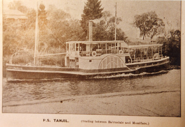
Photograph, 1910 c
Sepia photograph of postcard showing P S Tanjil in the Mitchell River Bairnsdale Wharf, house on rise opposite the wharf. Wharf decking across bottom of photo. Vegetation and pine trees on river bank. Tanjil travelling upstream. Bairnsdale VictoriaP.S Tanjil (Trading between Bairnsdale and Mossiface)ships and shipping, waterways, recreation -
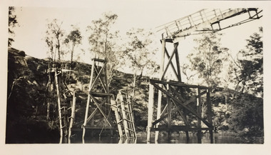
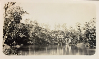 Kew Historical Society Inc
Photograph - Demolishing the Zig-Zag Bridge, 1929
Henry Beater Christian (1886-1962) , was a descendant of one of the earliest settler families in Kew. Employed at the Kew Asylum as a 'public servant', he was a skilled amateur photographer, photographing numerous scenes in Kew and on his travels around Victoria. The majority of his photographs date from 1916 to 1929. His finest photographs are housed in two photograph albums. Rare photograph of the demolition of the Zig-Zag Bridge linking the two asylums on either side of the Yarra River.Digital copy of a photograph from page 16 of the 47-page photograph album containing 261 gelatinous silver images, loaned by Diane Washfold with permission given to digitise and hold a copy in our collection. The Zig-Zag Bridge linked the grounds of the Yarra Bend and Kew Asylums. The wooden bridge was constructed in the 1870s and lasted through numerous floods until its destruction in 1929. A horizontal structure, the walkway was reached via a wooden staircase on the Kew bank of the river. The steps were required due to the different levels of the banks on this stretch of the river. This is a photo of the bridge showing the level of destruction caused by the initial damage from the flood and subsequent dismantling of the horizontal struts and walkway, prior to to its destruction by fire."Demolishing Zig-Zag / 6. 1929"henry beater christian (1886-1962), landscape photography, kew (vic.) — yarra river, christian-washfold collection, photograph albums, zig-zag bridge -
 Kew Historical Society Inc
Photograph - Demolishing the Zig-Zag Bridge, 1929
Henry Beater Christian (1886-1962) , was a descendant of one of the earliest settler families in Kew. Employed at the Kew Asylum as a 'public servant', he was a skilled amateur photographer, photographing numerous scenes in Kew and on his travels around Victoria. The majority of his photographs date from 1916 to 1929. His finest photographs are housed in two photograph albums. Rare photograph of the demolition of the Zig-Zag Bridge linking the two asylums on either side of the Yarra River.Digital copy of a photograph from page 16 of the 47-page photograph album containing 261 gelatinous silver images, loaned by Diane Washfold with permission given to digitise and hold a copy in our collection. The Zig-Zag Bridge linked the grounds of the Yarra Bend and Kew Asylums. The wooden bridge was constructed in the 1870s and lasted through numerous floods until its destruction in 1929. A horizontal structure, the walkway was reached via a wooden staircase on the Kew bank of the river. The steps were required due to the different levels of the banks on this stretch of the river. This is a closeup view of the bridge showing the level of destruction caused by the initial damage from the flood and subsequent dismantling of the horizontal struts and walkway, prior to to its destruction by fire."Demolishing Zig-Zag / 6. 1929"henry beater christian (1886-1962), landscape photography, kew (vic.) — yarra river, christian-washfold collection, photograph albums, zig-zag bridge -
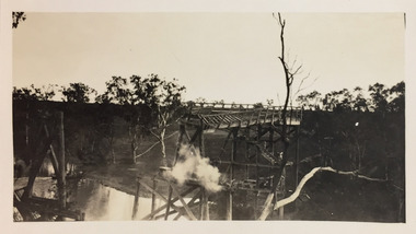 Kew Historical Society Inc
Photograph - Demolishing the Zig-Zag Bridge, 1929
Henry Beater Christian (1886-1962) , was a descendant of one of the earliest settler families in Kew. Employed at the Kew Asylum as a 'public servant', he was a skilled amateur photographer, photographing numerous scenes in Kew and on his travels around Victoria. The majority of his photographs date from 1916 to 1929. His finest photographs are housed in two photograph albums. Rare photograph of the demolition of the Zig-Zag Bridge linking the two asylums on either side of the Yarra River.Digital copy of a photograph from page 16 of the 47-page photograph album containing 261 gelatinous silver images, loaned by Diane Washfold with permission given to digitise and hold a copy in our collection. The Zig-Zag Bridge linked the grounds of the Yarra Bend and Kew Asylums. The wooden bridge was constructed in the 1870s and lasted through numerous floods until its destruction in 1929. A horizontal structure, the walkway was reached via a wooden staircase on the Kew bank of the river. The steps were required due to the different levels of the banks on this stretch of the river. This is a view of the bridge showing the level of destruction caused by the initial damage from the flood, the subsequent dismantling of the horizontal struts and walkway, and the setting on fire of the remaining structure."Demolishing Zig-Zag / 6. 1929"henry beater christian (1886-1962), landscape photography, kew (vic.) — yarra river, christian-washfold collection, photograph albums, zig-zag bridge -
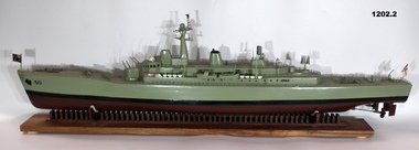 Bendigo Military Museum
Craft - MODEL & BASE, HMAS SWAN
Model of HMAS Swan built by Shipwright Charles Axiak. Original ship construction in Melbourne and entered service 1970. Was a River Class Destroyer. Model maker worked in British Dockyards during WW2 and emigrated to Australia in 1955. He worked in Williamstown dockyards involved with construction of the Swan,1. Model of River Class Destroyer. green in colour from water line. Black line and brown at bottom. Small Australian flag at front and naval flag at back. 2. Wooden stand, tailor made to hold the model of the 'Swan'. Brown in colour with long flat board and separate pieces of wood embedded in the base to make the cradle. High points of cradle covered by some white felt to protect boat. Bottom of stand has felt studs."50" painted at front of boat.ships model, hmas swan -
 Bendigo Military Museum
Map - MAP HUE VIETNAM, C.1960’s
The city of Hue is in South Vietnam. The map was used by a member of the AATTV during the Tet Offensive in Thau Thien province. Map brought home from Vietnam by Murray Stanley Metherall. Refer 590.2.Colour printed map of Hue Citadel on paper. Aerial view of land, river and building outlines.hue, vietnam, tet -
Glenelg Shire Council Cultural Collection
Negative - Negative - Glenelg River at Nelson, Victoria, Miss Zillah Maschmedt, photographer, c. 1936
Negative for a black and white photograph. Image shows Glenelg River at Nelson, Victoria, looking downstream. -
Glenelg Shire Council Cultural Collection
Negative - Negative - Glenelg River, Nelson, Victoria, c. 1936
Transparency for black and white photo. Nelson, Vic. view of Glenelg River, fence leading into water -
Glenelg Shire Council Cultural Collection
Negative - Negative - Nelson, Victoria, c. 1936
Transparency for black and white photo. Panoramic view of Nelson, Vic, looking towards river mouth -
Glenelg Shire Council Cultural Collection
Postcard - Postcard - Suspension bridge Casterton, 1900-1930
SOURCED FROM CASTERTON TOWN HALL (FORMER SHIRE OF GLENELG) Sourced from Casterton Town Hall (Former Shire of Glenelg)Postcard, black and white,, showing the suspension bridge at Casterton, view across river towards townshipFront: 'SUSPN BRIDGE CASTERTON' Back: Handwritten correspondence, addressed to 'Miss M. Sythaleigh, Henty St Casterton' -
 Federation University Historical Collection
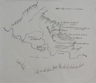
Plan, Dunn's Map of Early Gold Diggers at Golden Point, Ballarat, not dated
Hand drawn map in colour showing Yarrowee River and claims including James Oddie and Highett.dunn, dunn's map, comissioner's tent, oddie's claim, highett's claim, macdonald, suter & co claim, james oddie, golden point, gold discovery -
 Bendigo Historical Society Inc.
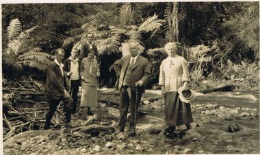
Photograph - BLACK AND WHITE PHOTOGRAPH: TAGGERTY RIVER MARYSVILLE 1924-5
black and white photograph - Family and friends at Taggerty River Marysville 1924-5. Marysville Victoria.photograph, person, male / female, taggerty river marysville 1924-5 -
Port Melbourne Historical & Preservation Society
Map - City of South Melbourne, 1854 - 1884
Detailed map of City of South Melbourne. Date uncertain. Shows early configuration of river and docks."South Melbourne, Sheet 2"emerald hill, town planning -
Port Melbourne Historical & Preservation Society
Map - Chart, Hobson's Bay, river and navigational aids, 1839 - 1843
On back is handwritten note - Hobson's Bay pp from HMS Beagle 1838-43.Map (Chart) of Hobson's Bay, River and Navigational Aids 1839. (Latrobe Library). in photographic form.melbourne harbor trust - port of melbourne authority, hobson's bay -
 Bendigo Historical Society Inc.
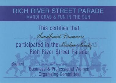
Document - SANDHURST DRUMMERS COLLECTION: CERTIFICATE, 1990
Documents. Blue Participation Certificate for Sandhurst Drummers from Rich River Street Parade 1990.document, memo, participation certificate -
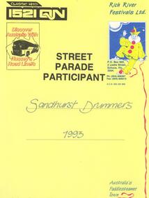 Bendigo Historical Society Inc.
Document - SANDHURST DRUMMERS COLLECTION: CERTIFICATE, 1993
Document. Certificate awarded to Sandhurst Drummers Street Parade Participant 1993 Rich River Festival.document, memo, certificate. -
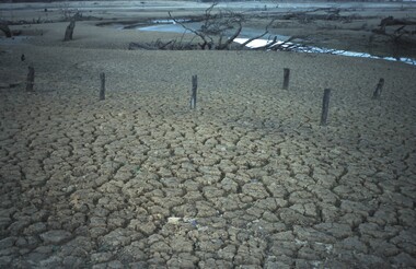
 Bendigo Historical Society Inc.
Slide - VAL DENSWORTH COLLECTION: DRY LAKE EPPALOCK, May 2004
Slide. Dry Lake Eppalock. The Campaspe River flowing so slowly through Lake Eppalock.slide, bendigo, dry lake eppalock., dry lake eppalock. -
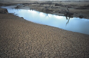
 Bendigo Historical Society Inc.
Slide - VAL DENSWORTH COLLECTION: DRY LAKE EPPALOCK, May 2004
Slide. Dry Lake Eppalock. The Campaspe River snakes through the dry bed of Lake Eppalock.slide, bendigo, dry lake eppalock., dry lake eppalock. -
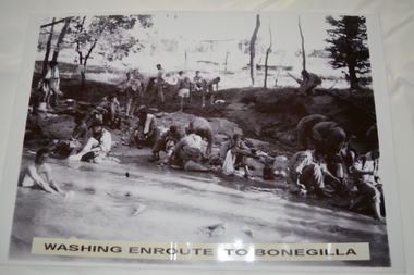 Wangaratta RSL Sub Branch
Photograph, c1940
In July 1940, the 2/24th Battalion was formed in Wangaratta. On the 27th September, after weeks of hard training the Battalion marched out to Bonegilla to continue training prior to overseas deployment to the Middle East in November, 1940. This image depicts soldiers bathing and washing during the 60 mile march.The 2/24th Battalion was an infantry battalion of the Australian Army, which served during World War II .A unit of all-volunteers, it was formed in July 1940 from primarily Victorian volunteers and was known as "Wangaratta's Own" because of the time the battalion spent in the town during its formative period prior to deployment overseas. It served in North Africa in 1941–1942 as part of the 26th Brigade, which was assigned to the 7th Division, before being reassigned to the 9th Division. In early 1943, the battalion returned to Australia and later took part in campaigns against the Japanese in New Guinea in 1943–1944 and Borneo in 1945, before being disbanded in 1946. The 2/24th suffered the highest number of casualties of any 2nd AIF infantry battalion. The Unit was granted the Freedom of the City by the Rural City of Wangaratta in 1990 and one of the first, if not the first, to receive this type of honour.Reproduced black and white photograph of unknown soldiers bathing and sitting on a river bank in bush land. Washing enroute to Bonegilla2/24th battalion, wangaratta -
Lakes Entrance Regional Historical Society (operating as Lakes Entrance History Centre & Museum)
Book, Rodwell, Daniel J, Flood Event Photographs June 2007, 2005
Research, interpretation and management recommendations for Batten's Landing site on the Tambo River, East Gippsland, Victoria.waterways, land settlement, mines and mining -
Lakes Entrance Regional Historical Society (operating as Lakes Entrance History Centre & Museum)
Photograph, Rev John Flynn, 1906
This is a photograph proof on light cardBlack and white photograph of view of Deddick River north of Buchan and old Deddick ruins VictoriaDeddick Ruins P36 Johyn Flynn Postcards from Buchantopography, waterways -
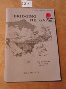 Stawell Historical Society Inc
Book, Ida Stanton, Bridging The Gap 1988 -- The History of Halls Gap From 1840 by Ida Stanton, 1988
Tales of Hall's Gap in the Grampians, as collected by the Pupils of Hall's Gap Primary School, from the descendants of Pioneer Families, and Recorded prior to 1940. Rerecorded from old well worn notes, by Grant W Greenwood, Head Teacher 1937-1939.Fawn cover with drawing of trees and mountain in the background. in the foreground is a bridge over a river, with a woman in a dray. Presented to Stawell Historical Society Ida Stanton May 1989stawell grampians