Showing 10946 items
matching a lake
-
 Ballarat Tramway Museum
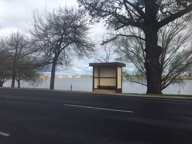
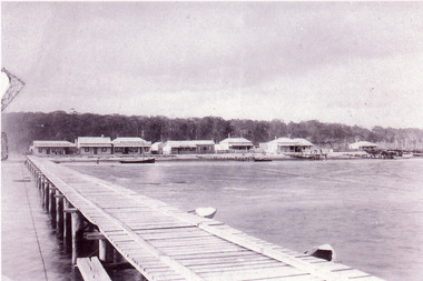
Photograph - Digital image, Warren Doubleday, Tram stop shelter with flat roof - Wendouree Parade near Dowling St, Sep. 2016
Former tram stop shelter in Wendouree Parade near Dowling St with Lake Wendouree in the background. Maintained by the City of Ballarat.Digital Image of the timber based shelter with flat roof - Wendouree Parade near Dowling St. Photographed 9/1991. See Reg Item 6526i3 for a c1971 image.trams, tramways, shelters, dowling st, wendouree parade -
 Friends of Ballarat Botanical Gardens History Group
Work on paper - Ballarat Water Supply 1837-1972, Chronology and Extracts From History, C 2009
This is an incomplete draft on work about the Ballarat Water Supply which is directly relevant to Lake Wendouree and the Ballarat Botanical Gardens.These pages give background to the development of the Ballarat Water Supply after 1972. 13 pages in random order, except for pp1-4 which form a chronology. The other 9 printed pages are part of a draft with some references cited.Nonedoctor john garner, ballarat botanical gardens, friends of ballarat botanical gardens, ballarat water supply, lake wendouree, commissioner j.a. chisholme, yuillle's swamp, j.b.humffrays, john garner collection, gardens, ballarat -
 Friends of Ballarat Botanical Gardens History Group
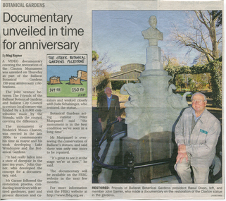
Work on paper - Ballarat Botanical Gardens Monument, The Claxton Memorial. Grave Ballarat Old Cemetery, 1997- 2012
Claxton was born in 1832 in England and settled in Ballarat in 1856. He was an active member of the Ballarat community and the development of the Lake and Gardens. Claxton's contributions to the development of Ballarat were significant especially the development of the Gardens and the Lake.01 Ballarat Courier article undated with coloured photo of the monument. 02 Thumbnail sketch of Claxton's life (3 Copies) 03 Legible small print Mayor's Report 04 The Claxton Memorial (Commentary for Video) p1 2copies and half of p1. Pages 1-4 2 copies Pages 1-6 one copy.03 Written in biro across the top of the page, "Mayor William Little from Mayor's Annual Report 1890".frederick moses claxton, claxton memorial, mayor of ballarat, development of the lake and gardens, ballarat's city fathers, foundation member of civic organisations in ballarat, english cholera, webster street, restoration of the claxton memorial, death of claxton, "modesty", john garner collection, garner, dr, ballarat, ballarat botanical gardens, gardens, claxton, grave, ballarat old cemetery -
 Hymettus Cottage & Garden
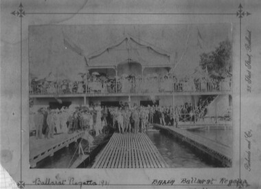
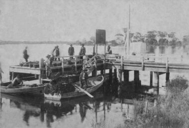
Photograph, Ballarat Regatta 1901
Photograph of Ballarat Rowing Club house on Lake Wendouree in 1901 with crowds celebrating the finish of an event at the annual rowing regatta..photograph, lake wendouree, rowing,lake wendouree, ballarat, regatta, 1901. -
 Lake Bolac & District Historical Society
Black and white photograph, E & M Rowley, pioneers at Lake Bolac, 1862
Edward and MaryAnn Rowley were pioneer settlers at Lake Bolac, taking up land in 1862. Their children were Sarah, Elizabeth, Maryanne, Deborah, Emily, Ellen, Eliza, Emma, Martha and Edward. The change-over station for stage coaches, including Cobb and C., and paddocks for resting horses, were on their property. The farm was later bought by J.T. Murray. The family are interred in the Lake Bolac Cemetery.lake bolac, rowley, pioneer settlers, 1862, murray, cobb and co. -
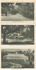 Bendigo Historical Society Inc.
Photograph - FOSTER AND WILSON COLLECTION: PICTURE FOLDER OF BENDIGO
Picture folder with 12 black & white scenes of Bendigo. Scenes include: Rosalind Park, Boatsheds on Lake Weeroona, The Conservatory, Panorama of Pall Mall, Interior of the Conservatory, Pall Mall, Queen's Gardens, The Lookout Tower, Pall Mall, Panorama from the Lookout Tower, Lake Weeroona, and The Fountain, P. O. and Soldiers' Memorial.place, bendigo, picturesque views of bendigo., foster & wilson collection, rosalind park, boatsheds on lake weeroona, the conservatory, pall mall, interior of the conservatory, queen's gardens, the lookout tower, panorama from the lookout tower, lake weeroona, the fountain, p.o. and soldiers' mem -
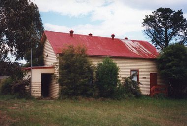 Lakes Entrance Regional Historical Society (operating as Lakes Entrance History Centre & Museum)
Photograph, 1999
Also another copy 10 x 15 of side view.Colour photograph of the Kalimna West Hall, situated on the Princes Highway, halfway between Lakes Entrance and Swan Reach, Victoria. A single storey weatherboard building with gabled corrugated iron roof with four ventilators. Small entry porch and side door. Hardiplank clad extension at rear. Kalimna West Lakes Entrance Victoriahouses -
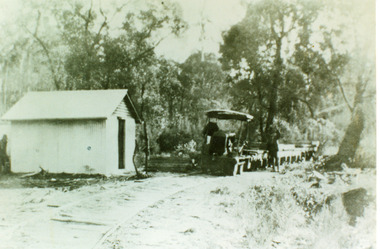 Lakes Entrance Regional Historical Society (operating as Lakes Entrance History Centre & Museum)
Photograph, 1930c
Black and white photograph of the tramline used to transport red granite from the quarry at Mississippi Creek to the landing at the head of the North Arm, Lakes Entrance, Victoria showing the converted Fordson tractor used to haul the trucks of stone on the 3 foot 6 inch line 105cm approximately 1920 to 1939. Lakes Entrance Victoriawaterways, vegetation -
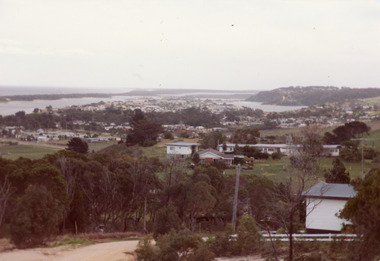 Lakes Entrance Regional Historical Society (operating as Lakes Entrance History Centre & Museum)
Photograph
Colour photograph of township of Lakes Entrance showing North Arm, North Arm Bridge, Jemmys Point, Mount Barclay, Kalimna Heights, Cunningham Arm and sand dunes on left. Looking west to Bullock Island and Rigby Island. Photo taken from near Telecom Tower on Merrangbaur Hill. Lakes Entrance Victoriaconstruction, bridges, waterways -
 Lakes Entrance Regional Historical Society (operating as Lakes Entrance History Centre & Museum)
Photograph, Holding George, 1975c
Colour photograph of Bullock Island showing Pecks fish processing factory Lakes Entrance Fishing Co-Operative, and PWD buildings, vehicles on picnic area of Marine Parade during one and only offshore power boat race. Spit opposite Club Hotel has grass and some bushes. Lakes Entrance Victoriaislands, land reclamation, waterways -
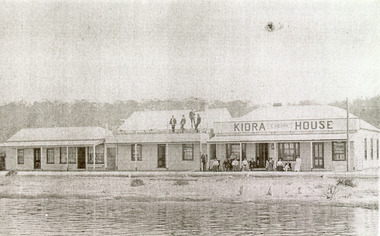 Lakes Entrance Regional Historical Society (operating as Lakes Entrance History Centre & Museum)
Photograph, 1920c
Also enlargement copy 16 x 25 cm|The house to the left was purchased by Mrs Hehir as extension to boarding house. On back - left Drapery? Mitchelson (Alvene's parents) and later double storeyBlack and white photograph of Kiaora House, showing a weatherboard building with iron roof. House to left. Balcony over the veranda four men standing on balcony, accessed via external narrow stairway. Twelve people in front of Kiora House, women in WW1 fashion. Sandy shore and lake in foreground. Lakes Entrance Victoriaworld war 1914-1918, guesthouses, tourism, waterfront -
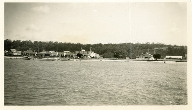 Lakes Entrance Regional Historical Society (operating as Lakes Entrance History Centre & Museum)
Photograph, 1930c
Black and white photograph of the Esplanade, showing buildings including Kiaora House, Heyfield Guesthouse, Kents Garage, and vacant blocks either side of Miss Bertha Hansen's guest house. Boats at jetty on edge of Cunninghame Arm. Kalimna escarpment in the distance background. Photo taken from the middle of the lake. Lakes Entrance Victoriaguesthouses, retail trade, boats and boating, waterfront, jetties -
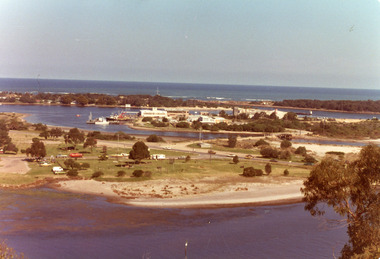
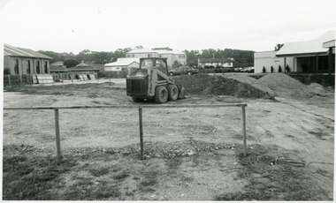 Lakes Entrance Regional Historical Society (operating as Lakes Entrance History Centre & Museum)
Photograph, Lakes Post Newspaper, 1993
Date made November 1993Black and white photograph of an earthmoving machine levelling the site of the old Bellevue Motel in readiness for a start on the third stage of the new Bellevue complex, Lakes Entrance, Victoria, being the motel units. Also in the image - Bellevue Apartments on Marine Parade, rear of Lakeside Motel, part of Bellevue Convention Centre. Lakes Entrance, Victoriamotels, architecture, machinery -
 The Beechworth Burke Museum
Photograph, c1960
The photograph depicts a view across the water at Lake Sambell. The image dates from approximately 1960. The present day park and reserve occupies the site of the former Rocky Mountain Mining Company, an open-cut sluice mine that began operations in the mid-Nineteenth Century and operated until the early 1900s, through the peak of Victoria’s Gold Rush. It was converted into a park and leisure area in the 1920s. Lake Sambell was formally opened to the public on Friday 5th October 1928 and was opened by the Victorian Government’s Minister of Lands, Mr Bailey, as part of initiatives to boost the economies and development of country towns. The lake was named after Mr L.H. Sambell, a shire engineer and secretary of the Forward Beechworth Committee who was involved in promoting the transformation of the mining site and promoting plantation forestry and tourism as alternative industries. £300 to begin the process was provided by Mr J. McConvill, a former resident of Beechworth, who is remembered in a street name adjacent to the lake. Residents of Beechworth have worked to raise funds to improve the Lake Sambell reserve several times, such as efforts in the 1930s and 1940s to raise the banks several feet to deepen the water for swimming purposes. Fundraising campaigns include the ‘Ugly Man’ competition conducted on behalf of the Wallace Park-Lake Sambell Development Scheme. The latter competition was run by the Fire Brigade Bend’s team as part of a larger competition called the ‘Mile of Pennies’; it was won by Mr Len Knight of Beechworth’s Commercial Hotel. The ‘Mile of Pennies’ was conducted at a Carnival held on New Year’s Eve, 1947. It was proposed by the Beechworth and District Progress Association. As well as improving swimming facilities, funds were raised to install a caravan park facility near the lake. Funds were also donated by commercial entities, such as £250 received from Zwar Bros. Pty Ltd. The photograph is significant as it shows the level of development of Beechworth in the early to mid-Twentieth Century. Sepia rectangular photograph printed on matte photographic paperObverse: nil. Reverse: 3470 / Velox (paper mark)beechworth, beechworth lake, lake sambell, lake, beechworth and district progress association, forward beechworth committee, ugly man, mile of pennies, wallace park lake sambell development scheme, wallace park-lake sambell development scheme, zwar bros, zwar, l.h. sambell, j. mcconvill, minister of lands, commercial hotel, len knight, rocky mountain mining company, rocky mountain mining co, gold rush, redevelopment, transformation, community fundraising -
 The Beechworth Burke Museum
Photograph, c1960
The photographs in this set depict views across the water at Lake Sambell. The images date from approximately 1960. The present day park and reserve occupies the site of the former Rocky Mountain Mining Company, an open-cut sluice mine that began operations in the mid-19th Century and operated until the early 1900s, through the peak of Victoria’s Gold Rush. It was converted into a park and leisure area in the 1920s. Lake Sambell was formally opened to the public on Friday 5th October 1928 and was opened by the Victorian Government’s Minister of Lands, Mr Bailey, as part of initiatives to boost the economies and development of country towns. The lake was named after Mr L.H. Sambell, a shire engineer and secretary of the Forward Beechworth Committee who was involved in promoting the transformation of the mining site and promoting plantation forestry and tourism as alternative industries. £300 to begin the process was provided by Mr J. McConvill, a former resident of Beechworth, who is remembered in a street name adjacent to the lake. Residents of Beechworth have worked to raise funds to improve the Lake Sambell reserve several times, such as efforts in the 1930s and 1940s to raise the banks several feet to deepen the water for swimming purposes. Fundraising campaigns include the ‘Ugly Man’ competition conducted on behalf of the Wallace Park-Lake Sambell Development Scheme. The latter competition was run by the Fire Brigade Bend’s team as part of a larger competition called the ‘Mile of Pennies’; it was won by Mr Len Knight of Beechworth’s Commercial Hotel. The ‘Mile of Pennies’ was conducted at a Carnival held on New Year’s Eve, 1947. It was proposed by the Beechworth and District Progress Association. As well as improving swimming facilities, funds were raised to install a caravan park facility near the lake. Funds were also donated by commercial entities, such as £250 received from Zwar Bros. Pty Ltd.The photographs are significant as they show the level of development in Beechworth in the middle of the Twentieth Century. Four sepia and black and white rectangular photographs printed on matte photographic paper. 3469.1: Obverse: nil Reverse: 3469-1 3469.2: Obverse: nil Reverse: 3469-2 3469.3: Obverse: nil Reverse: 3469-3 3469.4: Obverse: nil Reverse: 3469-4beechworth, beechworth lake, lake sambell, lake, beechworth and district progress association, forward beechworth committee, ugly man, mile of pennies, wallace park lake sambell development scheme, wallace park-lake sambell development scheme, zwar bros, zwar, l.h. sambell, j. mcconvill, minister of lands, commercial hotel, len knight, rocky mountain mining company, rocky mountain mining co, gold rush, redevelopment, transformation, community fundraising -
 Paynesville Maritime Museum
Photograph
On the Gippsland Lakes fish were caught from small (7m) boats and packed into baskets or boxes on the jetty before shipment to Melbourne.Photo shows fishermen and boats at a local jetty. -
Lakes Entrance Regional Historical Society (operating as Lakes Entrance History Centre & Museum)
Postcard, 1920 c
Also anothe black and white postcard of Lake scene from Fair Haven Mallacoota 05121.2 9 x 14 cmBlack and white postcard of jetty at Fair Haven guesthouse Mallacoota VictoriaJatty Scene at 'Fair Haven'Mallacootawaterways -
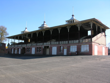 Ballarat Heritage Services
Digital photograph, Grandstand, City Oval, Ballarat
Originally known as Yuille's paddock, this oval is now called the City Oval. It is near Lake Wendouree previously known as Yuille's Swamp. -
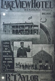 City of Ballarat Libraries
Photograph - Card Box Photographs, Advertisement for Lake View Hotel 1916. From Citizens & Sports publication
The Lake View Hotel is located on Wendouree Parade. The proprietor was R. Taylor. The advertisement also shows the hire of sailing and rowing boats. lake view hotel, wendouree parade, r. taylor, advertising, boatshed, vehicle, boats, ballarat -
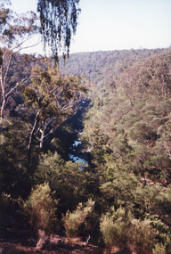 Lakes Entrance Regional Historical Society (operating as Lakes Entrance History Centre & Museum)
Photograph, 1999
Boggy Creek Gorge cuts through volcanics just before it meets salty water at Nowa Nowa Arm of Lake Tyers.Colour photograph from a vantage point of the distant Boggy Creek Gorge surrounded by steep tree and scrub covered ranges. Nowa Nowa Victoriavegetation -
Lakes Entrance Regional Historical Society (operating as Lakes Entrance History Centre & Museum)
Photograph, 1863 c
In 1863 George Grant, Surveyor Assistant, wife Sarah and family were living at Reeves River Lakes Entrance camped belowBlack and white photograph of Sarah Grant nee Batten and daughter Marion Elizabeth taken at unknown location Victoriagenealogy -
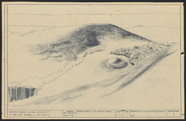 Robin Boyd Foundation
Drawing - Aerial perspective, Tower Hill Lake Reserve Museum, Jun-61
Project: Tower Hill Lake Reserve Museum drawn by Robin Boyd of Grounds, Romberg & Boyd. Drawing no 1. Aerial perspectiveSketch, Dyeline -
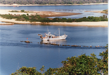 Lakes Entrance Regional Historical Society (operating as Lakes Entrance History Centre & Museum)
Photograph, Tambo Shire, 1990c
Second copyColour photograph of the south eastern shore of Rigby Island, Gippsland Lakes. It shows the scrub covered hummocks in the background, Hopetoun Channel, dumped sand which connects Snake Island and Rigby Islands, groynes into Narrows from Rigby Island. Fishing boat with scallop dredge moored in sheltered bay inside a groyne. Lakes Entrance Victoriaocean, waterways, topography, fishing industry -
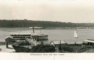 Lakes Entrance Regional Historical Society (operating as Lakes Entrance History Centre & Museum)
Postcard, Bulmer and Segerberg, 1912c
Black and white postcard showing view of township. Background shows Kalimna escarpment. Middle ground shows historic Club Hotel on left. Foreground shows Works buildings, school building, corner of Harbour Master's house on right. SS Gippsland at New Works wharf, with passengers. Small sailing boat on lake. Lakes Entrance VictoriaCunninghame from the New Worksjetties, township, boats and boating -
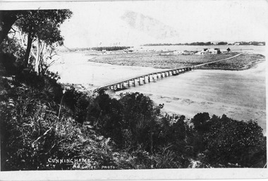 Lakes Entrance Regional Historical Society (operating as Lakes Entrance History Centre & Museum)
Postcard, 1888c
Black and white postcard of wooden bridge across the North Arm, showing sand hummocks Cunninghame Arm, Club Hotel, and die back of melaleuca on mudflats, caused by salination of Lakes after artificial entrance opened 1889. Vegetation on Kalimna Hill in foreground. Steamer on Cunninghame Arm centre top of photo. Lakes Entrance VictoriaCunninghame N Cairebridges, topography, township -
 Lakes Entrance Regional Historical Society (operating as Lakes Entrance History Centre & Museum)
Photograph, 1895c
Also copy 13.5 x 20 cmBlack and white photograph of the western view of the Esplanade, also known as Cunninghame, showing early business houses, and residences. Included is Mrs Gleeson's Boarding House, William Barke's store, Heyfield Coffee Palace, butcher shop. Three small jetties, one substantial jetty and two small boats beside lake. Lakes Entrance Victoriatownship, waterfront, retail trade, jetties -
 University of Melbourne, Burnley Campus Archives
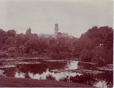
Photograph - Black and white and sepia prints, View of Botanic Gardens, Unknown
Black and white and sepia photographs. Views across the lake towards Government House. (a) Woman sitting on the lawn on the other side of the lake, labels on the plants visible (sepia). (b) Same view with caption, "6 Botanical Gardens." (c) Slightly different view. Photographs B91.409 to B91.417 appear to have come from the same photograph album.On reverse, "Government House - Melb from Botanical Gardens."lake, government house, royal botanic gardens, excursion, botanic gardens, view -
 Orbost & District Historical Society
black and white photograph
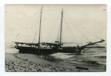
The “Glengarry” beached at Marlo The schooner Glengarry was a well-known trader on the Gippsland coast and had been stranded on a number of previous occasions including at the Natural Entrance joining the Gippsland Lakes to Bass Strait – Ninety Mile Beach, Lakes Entrance, c 1877 . In May 1898, the vessel struck a submerged object while crossing the Snowy River bar at Marlo and was beached, eventually becoming a total loss. Until t he railway came to East Gippsland goods were shipped from Marlo to Melbourne. This is a pictorial record of a well-known trading ship involved in that river transport.Three copies of a black / white photograph of the Schooner Glengarry wrecked in 1891 at the Snowy River entrance at Marlo.schooner-glengarry shipping transport-orbost -
 Eltham District Historical Society Inc
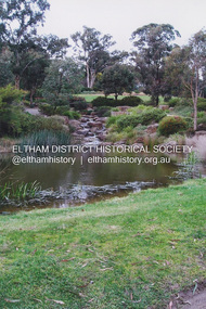
Photograph, Fay Bridge, Lake, Eltham Cemetery, 40 Mount Pleasant Road, Eltham, c.2009
Robert Boyle Landscape Design created the original design and construction of the lake in 1993. They are renowned local landscape designers and have carried out numerous projects at the Cemetery, including the major upgrades to the lakeside design in 2020. Title Lakeside Maintenance and Improvement Works Url https://www.elthamcemetery.com/item/25-lakeside-maintenance-and-improvement-works Description Improvement works to the lake and surrounding area July to October 2020.fay bridge collection, 2009, eltham, eltham cemetery, lake, mount pleasant road -
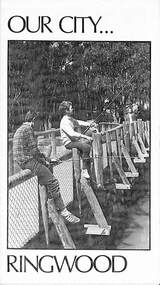 Ringwood and District Historical Society
Pamphlet, Our City - Ringwood (1972), 1972
Community information brochure issued in 1972 by Ringwood Council outlining local services, sporting, and cultural facilities. Includes names of Ward Councillors, and two City of Ringwood Free Tipping Vouchers valid until the end of 1973."Frontpiece: New bridge of pressure treated pine over Ringwood Lake." "Ringwood Must Grow, Not Go! With your money, Council provides these vital Services."rinx