Showing 10936 items matching " land"
-
 Federation University Art Collection
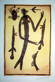
Work on paper - Artwork - printmaking, Lytlewode Press, A suite of limited edition prints by Paddy Fordham Wainburranga, 2003, 2003
Paddy Fordham Wainburranga (1932-2006) Area: Arnhem Land Country: Bamdibu (Bumdubu) near Bulman Station As a child, Paddy grew up in Maningrida an Aboriginal community on the top end of the Northern Territory. He started working as a boy around cattle yards, which finally led him to working as a stockman for 20 years. Before this, he spent much of his time hunting and learning culture and customs from his father and uncles. He could remember being taken to a sacred location where he was told many Dreamtime stories of how customs came to be and why Aboriginal people practice them. Paddy was part of the movement for equal rights for all Aborigines, actively involved in claiming Bumdibu as his traditional land for his clan. He resided over this land as Jungai (caretaker, policeman). Paddy was taught to paint by his father but did not begin to paint seriously until the early 1970s. He was also recognized as a story teller, bark painter, sculpture, dancer, singer and musician. He was familiar with Central Arnhem Land rock and bark painting traditions; however he developed an idiosyncratic style which fused the figurative schema of western Arnhem Land with the narrative capacities of the north-east producing dense pictorial paintings divided into sequential segments. A suite of seven limited edition prints using the sugar lift aquatint technique. .1) Yalk Yalk Woman Sugar Lift Aquatint Plate 75.0cm (H) x 49.0cm (W) Paper 1110cm (H) x 76.0cm (W) 2003 Edition: 73/100 .2) Walga Walga Sugar Lift Aquatint Plate 75.0cm (H) x 49.0cm (W) Paper 1110cm (H) x 76.0cm (W) 2003 Edition: 73/100 .3) Nammooroddoo Sugar Lift Aquatint Plate 75.0cm (H) x 49.0cm (W) Paper 1110cm (H) x 76.0cm (W) 2003 Edition: 73/100 Nammooroddoo Sugar Lift Aquatint Plate 75.0cm (H) x 49.0cm (W) Paper 1110cm (H) x 76.0cm (W) 2003 Edition: 73/100 .3) Nammooroddoo Sugar Lift Aquatint Plate 75.0cm (H) x 49.0cm (W) Paper 1110cm (H) x 76.0cm (W) 2003 Edition: 73/100 .4) Mun Gruk Gruk Woman Sugar Lift Aquatint Plate 75.0cm (H) x 49.0cm (W) Paper 1110cm (H) x 76.0cm (W) 2003 Edition: 73/100 .5 Mun Gruk Gruk Man Sugar Lift Aquatint Plate 75.0cm (H) x 49.0cm (W) Paper 1110cm (H) x 76.0cm (W) 2003 Edition: 73/100 .6) Mun Gruk Gruk Sugar Lift Aquatint Plate 75.0cm (H) x 49.0cm (W) Paper 1110cm (H) x 76.0cm (W) 2003 Edition: 73/100 .7) Lightning Man Sugar Lift Aquatint Plate 75.0cm (H) x 49.0cm (W) Paper 1110cm (H) x 76.0cm (W) 2003 Edition: 73/100 Donated through the Australian Government Cultural Gifts Programme by Katherine N. Littlewood, 2014artist, artwork, paddy fordham wainburranga, paddy fordham, wainburranga, printmaking, aboriginal, indigenous, churchill, dreaming -
 Kiewa Valley Historical Society
Papers - Cattle Grazing, Bogong High Plains
Cattle grazing. In the 1990s government departments allocated the number of cattle being taken up to the Bogong High Plains by the families who traditionally leased land there.Cattle grazing had been banned in other Alpine areas due to concerns of their impact on the environment. Kiewa Valley cattle graziers were caught up in the controversy as it was their tradition dating back to the 1840s. This controversy continues as cattle grazing was banned in 2005. 4 pages with black print: 1. 1989/90 Cattle Grazing Allocation and Dept. of Conservation Forests and Lands, Wodonga. 2. Proposed Future Stock Allocations 1991/92 list of 16 families 3. & 4. List of families, ear marks, brands etc. dated 22nd Feb. 1979 stapled togetherex S.C.A. / Benalla / Received 22nd Feb. 1979 / signedcattle grazing, kiewa valley farmers -
 Eltham District Historical Society Inc
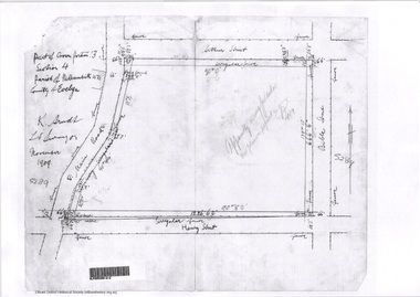
Document - Photocopy, Survey Fleld Notes of Part of Crown Portion 13, Section 4 at Eltham, Parish of Nillumbik, County of Evelyn, November 1909
Portion of land bounded by Main Road, Arthur Street, Bible Street, Henry Street Application 36708 K. Arndt, Licensed Surveyor, November 1909application 5289, arthur street, bible street, eltham, henry street, main road, map, survey plan -
 Eltham District Historical Society Inc
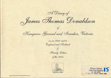
Folder, A Diary of James Thomas Donaldson of Kangaroo Ground and Ivanhoe, Victoria on an 1889 visit to England and Scotland & family letters of the 1850s, 1999
James Thomas Donaldson together with his family were pioneers in Kangaroo Ground from Scotland. James later bought land and built a house in Ivanhoe50 pages presented as transcriptions of original letters with images of some letters for illustration. Some black and white photos included. Also includes Photo of Alexander Donaldson with brief notes describing origin and some family history, 1pHG Booklet 10harry gilham collection, james thomas donaldson -
 Bendigo Military Museum
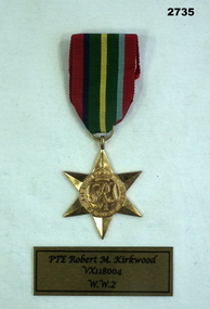
Award - MEDAL, Post WWII
ROBERT MACKENZIE KIRKWOOD initially enlisted No V32567 then transferred to AIF No VX118004 on 3.11.1942. At discharge from the Army 16.1.1946 he was a PTE in Advanced Land Headquarters. Pacific Star Medal with loose ribbon.VX118004 R M KIRKWOODmedals, military, history, passchendaele barracks trust -
 Greensborough Historical Society
Photograph - Digital Image, Watsonia High School Pool Construction 1976. Groundwork begins, 12/12/1976
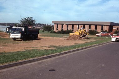
The swimming pool at Watsonia High School was commenced in 1976 and opened in 1977. This photo shows the commencement of groundwork for the pool, with construction vehicles on the land in front of the library.While the school has gone, the pool remains in 2019, operating as Yarra Swim School, Liat Way GreensboroughDigital copy of colour photograph, scanned from slide. Slide set at Item 6513.On slide "12/12/76"watsonia high school, swimming pools greensborough, yarra swim school -
 Greensborough Historical Society
Photograph - Digital Image, Watsonia High School Pool Construction 1976. First digging, 12/12/1976
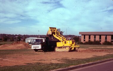
The swimming pool at Watsonia High School was commenced in 1976 and opened in 1977. This photo shows the commencement of groundwork for the pool, with construction vehicles on the land in front of the library.While the school has gone, the pool remains in 2019, operating as Yarra Swim School, Liat Way GreensboroughDigital copy of colour photograph, scanned from slide. Slide set at Item 6513.On slide "12/12/76"watsonia high school, swimming pools greensborough, yarra swim school -
![Photograph - Digital image, Willis Vale [Cows], 1920c](/media/collectors/4f729f5697f83e03086015b8/items/5502a0be2162f11024c30d9c/item-media/5502a0e52162f11024c31072/item-fit-380x285.jpg) Greensborough Historical Society
Greensborough Historical SocietyPhotograph - Digital image, Willis Vale [Cows], 1920c
Photograph of four cows at Willis Vale, home of the Partington family. It was located on the Plenty River at Partington's Flat Greensborough. Land use included farming and orchards. Home of the Partington familyDigital copy of black and white photograph.willis vale, partington -
 Greensborough Historical Society
Photograph - Digital image, Alwyn and tennis court 2014, 21/05/2014
In about 1945, Alan and Wyn Partington built a house (Alwyn) on 12 acres (now Whatmough Park) but this land was acquired by the Council for parkland and sports ovals. Digital copy of colour photograph.alwyn, alan partington, whatmough park -
 Yarra Ranges Regional Museum
Book, Receipt, Rent record book, Warburton
Bought by donor at a flea market. Receipt book for rent by Royce Bellman to James Dixon for a house and land in West Warburton, Victoria from 1915 - 1921. Small hard coverd navy blue book with lined pages. Paper receipts for rental payments by Royce Bellman to James Dixon are pasted onto the pages. Has ink inscriptions inside back and front covers ans addition sums written in pencil inside back cover. Inscibed in ink inside fron cover: Book of rental purchase between bellman and Dixon 101' per week Payable fortnightly from March 24th 1915. Inscibed in ink inside the back cover; Mrs JAmes Dixon 49 Stafford St Abbortsford Victoria post office 1910's, warburton, houses and housing -
 Tatura Irrigation & Wartime Camps Museum
Photograph, Arthur Knee, 1989
Camp 13 held German, Italian and Japanese POW's between 1941-1946. Has since reverted to grazing land. Owner Jim Finnegan of Murchison.Camp 13, Murchison, Victoria. Fence posts with concrete remains of kitchen and shower block beyond. German compound. Bare earth foreground, few eucalyptus.camp 13,, pow, murchison victoria, german pow's, internment camps -
Tatura Irrigation & Wartime Camps Museum
Photograph - original, Tatura Fruit Cannery, 1920 - 1922
Original photograph of T. Edwards and E. Quine (manager) in front of a fruit cannery, which operated for a short time on land near the Railway Station, Tatura.Black and white original photograph of 2 men outside Tatura's first cannery.on back: Tatura Cannery. T. Edwards, E. Quine. Presented to Tatura and District Historical Society by T. Flanagan. April 1985.tatura fruit cannery, t. edwards, e. quine -
Tatura Irrigation & Wartime Camps Museum
Carry Case, 1920
Used in conjunction with dumpy level, by Mr. Craven to survey agricultural land in the Goulburn Valley for the pruposes of setting out farm irrigation channels and check banksRectangular wooden box, divided into 5 sections with lid attached and closed with 2 metal fasteners on to 2 screws on the lid and key hole lock (no key). 2 leather straps with 2 buckles are attached by 2 metal bars, small screw driver and metal cap from telescope on dumpy level.carry case, dumpy level, craven b, tatura, surveying, irrigation, terrestrial -
Stawell Historical Society Inc
Book - Report, Grampians: A Report on recreation and Timber Uses of. Too Steep to Graze - Too Rocky to Plough, 1979
1) Conservation & Economics 2) Grampians Study Area 3) Land Use 4) Management 5) Criticisms of the Management Plan Appendix Graphs & MapsGreen Paper cover: Black tape on SpineConservation council of Victoria and Logo -
 City of Kingston
Pamphlet - Colour, Duffus Bros, Railway Reserve Highett, c. 1923
Sales plan for land in the suburb of Highett, titled Railway Reserve, incorporating properties along Wolseley Street, Livingston Street, Highett Road and Worthing Road. The developing urban area of Highett within the City of Kingston. This land sale pamphlet illustrates the subdivision of land within the municipality and the changing demographic of the district as new houses and shops are constructed close to infrastructure.Colour pamphlet advertising thirty eight shop and villa sites for sale at the Railway Reserve, Highett. Incorporates a map of the reserve with properties available on Wolseley Street, Livingston Street, Highett Road and Worthing Road. Handwritten in grey pencil: assumed sale price recorded on subdivisions 1-7, 10, 22, 23 and 34 Handwritten in grey pencil on subdivision 4: C. Nevill / City of Melbourne bank Handwritten in grey pencil across subdivision 7: 49' Handwritten in grey pencil across subdivision 21 and 22: 134' Handwritten in grey pencil across subdivision 25 and 26: 200' Handwritten in grey pencil across subdivision 36 and 37 and both top and bottom: 120' Hand drawn in blue pencil: outline of subdivision 4 Hand drawn in blue pencil: outline of subdivisions 7, 23, 28, 37, 38 along left hand side, subdivisions 38, 37 and 36 on Wolseley Street, subdivisions 30 and 29 along Wolseley Street, subdivisions 29 and 24 along the middle of the plan, subdivisions 24 and half of 25 along Livingston Street, half of subdivision 20 along the middle of the plan, subdivisions 21 and 22 along the Right of Way between Livingston Street and Highett Road, and along the right hand border of subdivision 7. Handwritten in ink adjacent to the subdivision plan, updside down, in the bottom right hand corner: 276 / 54 / 280 / 45 / 320 / 202 / 200 / 134 / horizontal line / 11/14 Handwritten in ink adjacent to the subdivision plan, updside down, in the bottom right hand corner: 1714)2200(15 / 1714 / horizontal line / 486land sales, highett -
 City of Kingston
Pamphlet - Colour, S. M. Reynolds, Estate Agent, Moorabbin Shire Hall Estate Second Section, c. 1930
Sales plan for land in the suburb of Moorabbin, bounded by South Road and Highbury Street, including Prince Street, Charming Street, Thomas Avenue and Keith Road.The developing urban area of Moorabbin within the City of Kingston. This land sale pamphlet illustrates the subdivision of land within the municipality and the changing demographic of the district as new houses are constructed close to infrastructure.Colour pamphlet advertising for private sale the Moorabbin Shire Hall Estate, Moorabbin. Incorporates a map of the estate bordered by South Road and Highbury Street, including Prince Street, Charming Street, Keith Road and Thomas Avenue.Handwritten in grey pencil on subdivision map below subdivision 63: £4 Handwritten in grey pencil on subdivision map below subdivision 66: 4 Handwritten in grey pencil on subdivision map below subdivision 80: 3. Handwritten in grey pencil on subdivision map below subdivision 81: 4 Handwritten in grey pencil on subdivision map below subdivision 83: 2 Handwritten in grey pencil on subdivision map below subdivision 96: £3 Handwritten in grey pencil on subdivision map below subdivision 97: 3 Handwritten in grey pencil on subdivision map to the left of subdivision 102: 3 Handwritten in grey pencil on subdivision map on the corner of Thomas Avenue and Highbury Street: vertical line next to a square with a cross in it.land sales, estate, moorabbin -
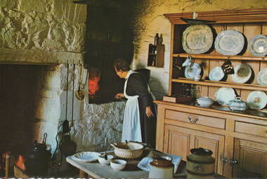 Sunbury Family History and Heritage Society Inc.
Postcard, Jocelyn Burt, Kitchen at Emu Bottom Homestead
The postcard shows the kitchen at 'Emu Bottom' which is almost the same as when the homestead was built in the 1930s when George Evans acquired the land and built the homestead.Images like the one on the postcard provide visual information relating to past domestic living and life.A non-digital coloured photograph in post card format with a crinkled edge, of a lady in a kitchen cooking over a Firestone. A large dresser is to her right and had a display of china plates and bowls on the open shelves.kitchens, emu bottom, george evans, sunbury -
 Phillip Island and District Historical Society Inc.
Photograph, 1978/79
The Chicory Kiln shown in the photograph is situated on land owned by the McIlwraith family in the 1870s. It is at Heath Hill on the Rhyll-Newhaven Road and is one of the oldest on Phillip Island.Coloured photograph showing a Chicory Kiln on the property which belonged to the McIlwraith family.local history, photographs, buildings - historical, housing, rural industry, coloured photograph, john cook, phillip island, mcilwraith homestead -
Bendigo Historical Society Inc.
Document - CONNELLY,TATCHELL & DUNLOP, c 1906
Connelly, Tatchell & Dunlop. 1a Victoria Transfer of Land 1 sheet. Jabez Carter formally of Kerang paid to me the sum of 832 pounds by. Albert Henry Sims of Echuca farmer Charles Williams Sims of the Grove Family. Excs of the will of Samuel Lewis late of Pine Grove. Farmer deceased. A.H Sims and C.W. Sims being entitled to be reg **** of the ** land in equal shares as tenants in common by virtue of the devises to them that *** in the said will & **** of the sum of 12 pound 10 by the said A.H. Sims & C.W. Sims paid with said A.T Chappell do *** with the **** by the **** of the said A.H. Sims & C.W. Sims as such ****as **** of the said A.H. Sims: C.W. Sims and A.T. Chappell as such devices of transfer to the o' A.H.Sims & C.W. Sims in equal shares as tenants in common. All my estate and interest in ALL THAT piece of Land being all 3 of sec A Par of Kerang ** from **** 320ac. A.R.P 320.0.23. Duty 400 pounds. Annie Turner Chappell of Pine Grove married woman. Signed by the said : Jabez Carter in the presence of G.H.T south Bgo. Signed by the ** A.H. Sims in the presence of Mr A. Atkynes solicitor Echuca. Signed by ** C.W. Sims in the presence Mr A. Atkynes. Signed by ** A.T. Chappell in the presence of John Crawford JP. Dated the 4th day of January One thousand 9 hundred and seven. ( 4\1\1907 ). FRONT OF TRANSFER - **** : C/T. 3214/ 642711 for this transfer of even sale DATED 4th January 1907. Jabez Carter Esq to **** A.H Sims & C.W Sims. Engel DCR 16.11.06. Printed at ' The Bendigo Independent ' OfficeThe Bendigo Independent Office -
 Ringwood and District Historical Society
Plan - Proposed Ringwood East Railway Station, VR Ringwood-Croydon (Dublin Road) - 1923
Technical drawing of "Proposed Station At 16Mls 38Chs 89Lks (Dublin Road)" inluding boundary line, red shaded platform with station buildings, and green shaded possible future "up" track. Surrounding streets include Dublin Road, Patterson Street, and subsequent hand-written additions of Railway Avenue, Lawrence Grove, Stanley Avenue, Wenwood Street, and Lois Street. Land title details of Patterson Street properties mainly illegible.Scale: 40'=1". Possible future (platform) extension for 8 car trains (and) extension for 10 car trains. -
 Kiewa Valley Historical Society
Newspaper Article - Thomas Briggs, 5th March 1988
Thomas Briggs was a pioneer of the Tawonga District. He worked on his parent's farm, selling goods, droving pigs and travelling to Yackandandah and Bright. He worked with pick and shovel on the Tawonga to Bright Road in 1902. He took up 320 acres of wild forest in Tawonga at 10 cents per acre per year for 20 years. He built a slab and shingle hut and a boundary fence. In 1886 he married Annie Maria Platt parenting 5 sons and 2 daughters until Annie died in 1953, aged 86 years.Thomas Briggs was a pioneer living in the Kiewa Valley with his parents and then with wife and family. This article is a history of his life from 1862 until 1887. See KVHS 0850 for information on the dray used to make the Tawonga Gap road - owned by John Briggs.Newspaper article Page 34 Border Morning Mail, Saturday, March 5, 1988 - Thomas Briggs Born 3rd Nov. 1862 who lived with his family at Upper Gundowring. His travels in the area including the Tawonga Gap and its construction in 1902 and his taking up of land in Tawonga in 1880. The article finishes in 1887 when he married Annie Maria Platt. The Thos Briggs story continues next week.thomas briggs; tawonga; kiewa valley; annie platt -
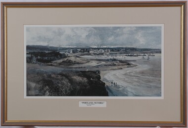 Glenelg Shire Council Cultural Collection
Print, Albert Henry Fullwood, Portland Victoria, c. 1886
NilScene of Portland Harbour. View includes people walking on beaches, jetties, moored boats (some with sails, some without). Upper centre of image shows a town, with a church to the right. To the left centre is a planned garden with people promenading. In foreground is empty land with a few seagulls. A train track enters the image on bottom centre. Print is predominantly in shades of blue, grey and brown. Mounted in dark cream matt, in wooden frame with glass.Front: A. Hy Fullwood (lower left, grey paint) "Portland Victoria" A. H. Fullwood 1836-1930 (printed below image) Back: (no inscriptions) -
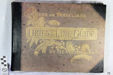 Flagstaff Hill Maritime Museum and Village
Book - Reference guide, Charters for Travellers Orient Line Guide
Book, titled “Orient Line Guide, Charters for Travellers by Sea and by Land”. Illustrated Guide of the Orient Line of Steamers between England and Australia. Issued on behalf of the Orient Steam Navigation Company Limited and the Pacific Steam Navigation Company, by the managers of the line, F. Green & Co. – Anderson, Anderson & Co. London, Contract with the Government of New South Wales. Brown leather and cloth cover with gold lettering and fine gold floral decoration. flagstaff hill, warrnambool, shipwrecked-coast, flagstaff-hill, flagstaff-hill-maritime-museum, maritime-museum, shipwreck-coast, flagstaff-hill-maritime-village, charters for travellers orient line guide, book, steam ship travel, passage from england to australia, orient steam navigation company limited, pacific steam navigation company, f. green & co. – anderson, anderson & co, e.c. maclure m macdonald -
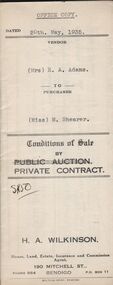 Bendigo Historical Society Inc.
Document - H.A. & S.R. WILKINSON COLLECTION: CONTRACT OF SALE
Conditions of sale by private contract dated 20th May, 1935 between Mrs. E.A. Adams (seller) and Miss M. Shearer (buyer) for land situate 43 Jackson Street, Long Gully being Crown allotment 181 section A and described in certificate of title volume 5564 folio 1112609, together with 4-roomed weatherboard dwelling and all sundry. Price 190 pounds. Also 2 receipts from City of Bendigo for rates.organization, business, h.a. & s.r wilkinson real estate -
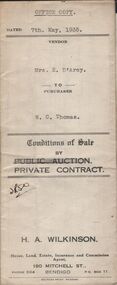 Bendigo Historical Society Inc.
Document - H.A. & S.R. WILKINSON COLLECTION: CONTRACT OF SALE
Conditions of sale by private contract dated 7th May, 1935 between Mrs E. D'Arcy (seller) and W.C. Thomas (buyer) for land situate no.55 Wattle Street, Bendigo being Crown allotments 5 & 5A section 129C described in Crown grant volume 563 folio 112554 and Crown grant volume 2079 folio 415637 together with 6-roomed weatherboard dwelling and all sundry. Price 500 pounds.organization, business, h.a. & s.r wilkinson real estate -
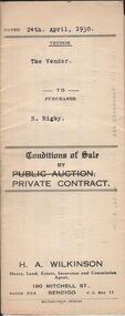 Bendigo Historical Society Inc.
Document - H.A. & S.R. WILKINSON COLLECTION: CONDITION OF SALE
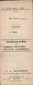
Conditions of sale by private contract dated 24th April 1930 between H.A. Wilkinson (seller) and R. Rigby (buyer) for land situate Vinton Street, California Gully being such parts as lie above the depth of fifty feet below the surface and being Crown allotment 589 section M borough of Eaglehawk described in Crown grant volume 3293 folio 658581, together with weatherboard dwelling and all sundry. Price 85 pounds.organization, business, h.a. & s.r wilkinson real estate -
 Bendigo Historical Society Inc.
Document - H.A. & S.R. WILKINSON COLLECTION: CONDITION OF SALE
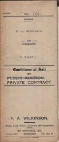
Conditions of sale by private contract dated 12th May, 1932 between H.A. Wilkinson (seller) and S. Rigby (buyer) for land within the special settlement area situate Junortoun containing 17 acres, 1 rood, 27 perches being allotment 37F Parish of Wellsford, County of Bendigo described in Crown grant volume 4485 folio 896958, together with 4-roomed weatherboard dwelling and all sundry. Price 575 pounds.organization, business, h.a. & s.r wilkinson real estate -
 Bendigo Historical Society Inc.
Document - H.A. & S.R. WILKINSON COLLECTION: CONTRACT OF SALE
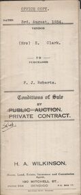
Conditions of sale by private contract dated 3rd August, 1934 between Mrs, E. Clark (seller) and F.J. Roberts (buyer) for land situate No. 7 Cobden Street, Bendigo at present occupied by Mrs. Fallon as tenant, being part of Crown allotment 7 and 8 section 65C described in certificate of title volume 4710 folio 941957, together with 6-roomed weatherboard dwelling and all sundry. Price 450 poundsorganization, business, h.a. & s.r wilkinson real estate -
 Bendigo Historical Society Inc.
Document - H.A. & S.R. WILKINSON COLLECTION: CONDITION OF SALE
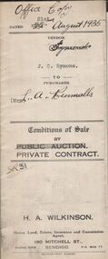
Conditions of sale by private contract dated 22nd August 1935 between J.C. Symons (seller) and Mrs L.A. Runnalls for land situate corner Goyne Road and Epsom Road, Epsom, being Crown allotment 4 and 8 section 25 containing approx. 3 acres, 2 rood and 9 perches and occupied by Mr. Makeham as tenant, together with 4-roomed weatherboard dwelling and all sundry. Price 340 pounds.organization, business, h.a. & s.r wilkinson real estate