Showing 10536 items
matching lander
-
 Bendigo Historical Society Inc.
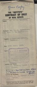
Document - H.A. & S.R. WILKINSON COLLECTION: CONTRACT OF SALE
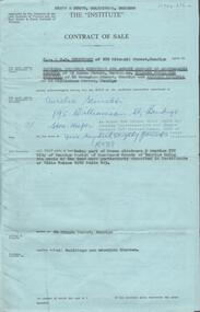
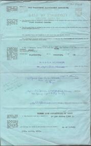
The Institute of Real Estate contract of sale dated 30th June, 1966 between Mr. C.J. Walters (seller) and Mr. C.J. Sandiford & Mrs. F.L. Sandiford (buyer) for land situate 3 Norfolk Street, Bendigo being part of Crown allotment 168, 311 and 312 section K described in certificate of title volume 6235 folio 960, together with all floor coverings, blinds, curtains and electric light fittings and shades. Price $7,000. Solicitors for vendor: Messrs. Watson, James & Rogers - Bull Street, Bendigo. Solicitor for purchaser: Messrs E.S. Cahill & Son - View Street, Bendigo.organization, business, h.a. & s.r wilkinson real estate -
 Bendigo Historical Society Inc.
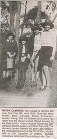
Newspaper - JENNY FOLEY COLLECTION: HAPPY CAMPERS
Bendigo Advertiser '' The way we were''from 2002. Happy campers: Girl Guides at Somers Hill near One Tree Hill, circa 1937. From left: Beryl Brown, Mary Runnalls, Elaine Emmerson, Audrey Young. The Girl Guides had a stone hut taken from the site on a piece of land donated by the Keck family. It was situated beside the race between Keck's nursery and One Tree Hill. The site was named Somers Hill after Lady Somers, the chief commissioner of the Girl Guides, and the wife of the Governor of Victoria. Vandals completely destroyed the building in the 70s. The clip is in a folder.newspaper, bendigo advertiser, the way we were -
 Bendigo Historical Society Inc.
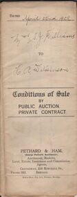
Document - H.A. & S.R. WILKINSON COLLECTION: CONDITION OF SALE
Conditions of sale by private contract dated 22nd April, 1922 issued by Pethard & Ham between Sarah Jane Williams (seller) and Henry Archibald Wilkinson (buyer) for land part of Crown allotment 54 section M Parish of Sandhurst, city and county of Bendigo described in certificate of title no. 2500 folio 499984. Also part of Crown allotments No. 53 and 54 certificate of title volume 2545 folio 508851, together with 7-roomed brick dwelling. Price 415 pounds Also for documents from Tatchell,Dunlop, Smalley & Palmer Solicitors to Mr. H.A. Wilkinson details the settlement of the Williams estateorganization, business, h.a. & s.r wilkinson real estate -
 Bendigo Historical Society Inc.
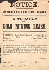
Document - NOTICE: APPLICATION FOR GOLD MINING LEASE
1880's Aged Paper ' Notice To All Persons Whom It May concern - Application for gold Mining Lease stating 'I hereby give notice , that the applicant undernamed did, on …leave with the Warden at… an application for a Gold Mining Lease of …of …and which, under the direction of the said Warden , I have the day of the date hereof surveyed ; and that any person desiring to object to the issue of the said Lease must enter his objection within seven clear days from the data of this Notice at the office the Warden ; and that this land is protected from occupation for any purpose whatsoever . Dated …188, by authority: John Ferres , Government printer, MelbourneJohn Ferres , Government printer , Melbournegold, mining, lease, ' notice to all persons whom it may concern - application for gold mining lease / john ferres , government printer , melbourne -
 Bendigo Historical Society Inc.
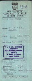
Document - H.A. & S.R. WILKINSON COLLECTION: CONTRACT OF SALE
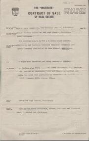
Contract of sale of real estate between Mr. R.A. Santon (vendor) and Mr. A.L. & A.K. Stringer (purchaser) dated 17th, July, 1962. Solicitor for vendor: Messrs. E.S. Cahill & Son, View Street, Bendigo. Solicitor for purchaser: Messrs Watson, James & Rogers, Bull Street, Bendigo. Property: Lot 21, Mahon Avenue, Bendigo, being lot 21 on plan of subdivision no. 31961 lodged in the office of titles parish of Sandhurst and being the whole of the land comprised in certificate of title volume 8310 folio 930 having a frontage of 53 feet to Mahon Avenue by a depth of 120 feet. Price 550 pounds.organization, business, h.a. & s.r wilkinson real estate -
 Bendigo Historical Society Inc.
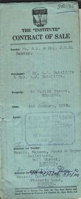
Document - H.A. & S.R. WILKINSON COLLECTION: CONTRACT OF SALE
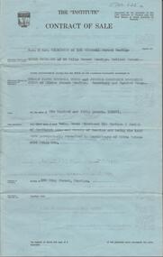
Contract of sale dated 4th January, 1960 between Mr. G. L. & Mrs. J. E. M. Baxter (vendor) and Mr. A. W. & Mrs. A. J. Sutcliffe (purchaser). Solicitor for vendor: Messrs. Watson, James & Rogers, Bull Street, Bendigo. Solicitor for purchaser: Messrs. Cohen Kirby & Co. Victoria Lane, Bendigo. Property 50 Havlin Street, Bendigo being part of Crown allotments 392 and 393 section H, land described in certificate of title volume 5514 folio 695 together with all floor coverings, blinds, curtains, and electric light fittings and shades. Price 3,075 pounds.organization, business, h.a. & s.r wilkinson real estate -
 Bendigo Historical Society Inc.
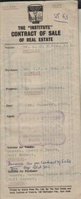
Document - H. A. & S. R. WILKINSON COLLECTION: CONTRACT OF SALE
Contract of sale of real estate dated 6th January, 1966 between Mr. A. G. & Mrs. J. A. Douglas (vendor) and Mr. I. J. & Mrs. J. M. Schultz (purchaser). Solicitor for vendor: Messrs. Hyett & Hyett, Bull Street, Bendigo. Solicitor for purchaser: Messrs. Watson, James & Rogers, Bull Street, Bendigo. Property 53 Horace Street, Bendigo being part of Crown allotment 13 section 96C land described in certificate of title volume 4196 folio 186 together with all floor coverings, blinds, curtains and electric light fittings and shades. Price 2,650 pounds.organization, business, h.a. & s.r wilkinson real estate -
 Bendigo Historical Society Inc.
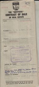
Document - H. A. & S. R. WILKINSON COLLECTION: CONTRACT OF SALE
Contract of sale of real estate dated 12th November, 1965 between Mrs. K. M. Washington (vendor) and Mr. D. E. & Mrs. D. M. Semmens (purchaser). Solicitor for vendor: Messrs. Watson, James & Rogers, Bull Street, Bendigo. Solicitor for purchaser: Messrs. Watson, James & Rogers, Bull Street, Bendigo. Property 12 Denovan Street, Bendigo being part of Crown allotment 2A section 47C land described in certificate of title volume 8157, folio 154 together with all floor coverings, blinds, curtains and electric light fittings and shades. Price 1,675 pounds.organization, business, h.a. & s.r wilkinson real estate -
 Bendigo Historical Society Inc.
Document - H. A. & S. R. WILKINSON COLLECTION: CONTRACT OF SALE
Contract of sale of real estate dated 30th June, 1965 between Mrs. H. F. Blabey (vendor) and Sandhurst * Northern District Trustees Executors& Agency Company limited (purchaser). Solicitor for vendor: Mr. E. M. Monotti, View Street, Bendigo. Solicitor for purchaser: Mr. E. M. Monotti, View Street, Bendigo. Property: 266High Street, Bendigo being part of Crown allotments 10 and 14 section 11B land describer in certificate of title volume 4375 folio 995 with all floor coverings, blinds, curtains and electric light fittings and shades. Price 1,050 poundsorganization, business, h.a. & s.r wilkinson real estate -
 Bendigo Historical Society Inc.
Document - H. A. & S. R. WILKINSON COLLECTION: CONTRACT OF SALE
Contract of sale dated 19th November, 1964 between National Trustees Executors and Agency Company of Australasia on behalf of Estate Charles Frederick Stilwell and Walford Stilwell (vendor) and Mr. A. Scinetti as agent for Mr. T. H. E. Hoy & Mrs. P. L. Hoy (purchaser). Solicitor for vendor: Messrs. Hyett & Hyett, Bull Street, Bendigo. Solicitor for purchaser: Messrs. Watson, James, Rogers, View Point, Bendigo. Property 60 Olinda Street, Bendigo being part of Crown allotment 9 section 77C land described in certificate of title volume 4786 folio 115. Price 580 pounds.organization, business, h.a. & s.r wilkinson real estate -
 Bendigo Historical Society Inc.
Document - H. A. & S. R. WILKINSON COLLECTION: CONTRACT OF SALE
Contract of sale of real estate dated 18th December, 1962 between Mr. J. Coco & Mr. M. Storti (vendor) and Mr. E. A. & Mrs. D. J. Sprigg (purchaser). Solicitor for vendor: Watson, James & Rogers, Bull Street, Bendigo. Solicitor for purchaser: E. S. Cahill & Son, View Street, Bendigo. Property: Lot 2 McKenzie Street West, Golden Square being lot 2 on plan of subdivision No. 56256 land described in certificate of title volume 8375 folio 655. Price 4,000 pounds. Attached 5 letters between the parties and tradies detailing jobs to be done on the property.organization, business, h.a. & s.r wilkinson real estate -
 Bendigo Historical Society Inc.
Document - H. A. & S. R. WILKINSON COLLECTION: CONTRACT OF SALE
Contract of sale dated 17th October, 1957 between Mr. E. Buckland (vendor) and Mr. T. J. M. & J. C. B. Tweed (purchaser). Solicitor for vendor and purchaser: Watson, James & Rogers, Bull Street, Bendigo. Property: 163 King Street, Bendigo being Crown allotment 96A section C Parish of Sandhurst, City of Bendigo land described in certificate of title volume 4354 folio 608. Price: 650 pounds. Attached: statement pursuant to section 34 of the estate agents act 1956 and engagement or appointment in writing pursuant to section 33 of the estate agents act 1956.organization, business, h.a. & s.r wilkinson real estate -
 Bendigo Historical Society Inc.
Document - MALONE COLLECTION: GREETING CARDS
Document. Greeting Cards. Small cream card with raised border. Inside the border is a black circle inside a gold border. Inside the black circle is a scene with a red sailing boat with gold sea and sky. The moon setting behind the water. On the right is black land with a light house. 'Kind Thoughts the Gulf of Distance Span' is printed and underlined in black with black edged gold capitals. The K is cream with gold edges, filigree and border on a red background. Left and bottom of the K are black leaves and gold flowers.The underlining and capitals are decorated too. Card & insert are held together with a small red ribbon.person, greeting cards, malone collection, malone collection, greeting cards -
 Bendigo Historical Society Inc.
Document - MCCOLL, RANKIN AND STANISTREET COLLECTION: PLAN OF AREA LEASE 10425, 10733 AND 10734, 1934
Plan of area applied for on lease No 10425, 10733 and 10734. Applied for by Mr. R.A. Rankin. Plan shows Marong Road, state school site ; leases held by H.E. Kronk, Francis Gramann; T. Wearne; C.E. Foggitt; A. Pitcher, Crown land and Aur. licences also marked. Lease numbers marked on plan. Map signed on bottom by Garnet G. Birch on 26.11.1934. On top Rh side in black pen " applications for the Minister of Mines Authority under section 5 (1) of the Mines Act 1928 to enter upon and occupy for mining purposes such portion of allotments lodged on 19/2/35'gold, mining, lease, mining, leases, kronk, garnet g. birch -
 Bendigo Historical Society Inc.
Book - AILEEN AND JOHN ELLISON COLLECTION: PRACTICAL BOOK AGRICULTURAL SCIENCE
A black cover book, on the first page a cut out of a woman in a garden and on the facing page in black pen: practical book agricultural science. L. John Ellison "Jacka Jacka", Joan, Vea(?) Horsham and the date 1940. Also in green pen at the top of the page: Beauty born 04/01/1962. On the following 2 pages an index of topics and dates of entry, the first date is February 27 and the last November 30th, there are 29 topics taking up 73 pages. the rest of the book is taken up by cuttings from the Weekly Times and the Mail mainly about land and history of the Horsham, Wimmera area.books, school, practical exercise book agricultural sci -
 Bendigo Historical Society Inc.
Document - CONNELLY, TATCHELL, DUNLOP COLLECTION: SIMMS TO LUXTON & CARTER
Documents enclosed in red ribbon relating to mortgages between Samuel Simms and Messrs. Luxton and Carter, portions 306 and 307 Parish of Lauriston, County of Dalhousie dated 10th. March, 1888. Conditions of Sale ( blue document ) between Thomas Luxton to Samuel Simms ( C. Yeo and Sons as agents for the vendor ). Agreement between Mrs. Annie Turner Chappel, of Pine Grove, with Messrs. A.H. Sims and C.W. Sims. ( F.N.H. Atkyns, Barrister & Solicitor, High Street, Echuca, 1906 ) and Transfer of Land document, between Thomas Luxton of Kangaroo Flat to Samuel Sims of Pine Grove, near Mitiamo.organisation, union, connelly, tatchell & dunlop, annie turner chappel, a.h. sims, c.w., sims. f.n.h. atkyns, thomas luxton, jabez carter, pine grove, mitiamo -
 Bendigo Historical Society Inc.
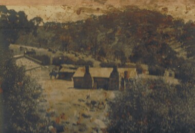
Photograph - THE SPRINGS, SEDGWICK
Photograph - black and white. Photograph of 'The Springs, Sedgwick', 14 miles from Bendigo. Rocky, hilly landscape with scattered trees, two chimneys on the main building in the centre, horse and rider approaching the building. Also 3 current photographs taken by Phillip Wilkin on July,2009. The 3 current photo's showing bluestone ruins - it is the same building on the left of the old photo - not the building with 2 chimney's, the one hidden behind trees (you only see part of it). Phillip's grandfather (Charles Wirth) moved here in 1901, along with his parents and grew up in that building (now ruined), the family still own the land.place, land, the springs, sedgewick., the springs, sedgwick. -
 Clunes Museum
Document - CLUNES DOCUMENT
.1 CLUNES TOWN COMMON, 1861, REGULATION FOR THE TOWN COMMON .2 PETITION CLUNES MINERS - 1856 - 7 - PETETION OFMINERS, STOREKEEPERS AND OTHERS RESIDING IN CLUNES .3 BEER BILL, PETITION TO BE ABLE TO SELL ALVOHOL IN CLUNES 1860-1861 .4 PORT PHILIP AND COLONIAL GOLD MINING CAMP - COPY OF CORRESPONDENCE BETWEEN THE SOLICITOR GENERAL AND CLUNES MINING CAMP 1858 .5 LEGISLATIVE ASSEMBLY - EIGHTS REPORT OF THE PRINTING COMMITTEE 17/12/1861 .6 CROWN LAND BILL. PETITION TO WITHDRAW THE BILL AND REPLACE IT WITH A NEW BILL 1856-7 .7 PROCLAMATION OF GOLD FIELDS COMMON 1860-1clunes town common, minerspetition, beer bill, legislative assembly, crown land bill, gold fields common, john ferres -
 Victorian Aboriginal Corporation for Languages
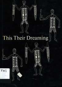
Book, Ann E Wells, This their dreaming : legends of the panels of Aboriginal art in the Yirrkala Church, 1971
Some time before the end of the year 1962, two great panels of Aboriginal art were begun. They were painted for part of a screen placed behind the Communion table in the Yirrkala church, and represented the two main, creative legends governing the lives, the behaviour and the ritual of the Aborigines belonging to a wide area of northeast Arnhem Land. Gives a brief outline of circumstances surrounding the panels. Lists the artists for each moiety. Maps show the territory of the people mentioned in the text. For each panel, there is a description of each section and an explanation of associated myths. Dua panel - the Djankawu journeys. Yiritja panel - legend of Banaitja. Glossary of terms.b&w art reproductionsyirrkala, yirrkala church, arnhem land -
 Bendigo Historical Society Inc.
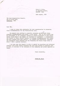
Document - PETER ELLIS COLLECTION: LETTER, 20th August, 1980
Letter (11 Pages) from Peter N Ellis to the Land Conservation Council. Letter refers to proposed State parks - Kamarooka State Park and Whipstick State Park. other areas mentioned are the Wellsford Forest, Mandurang Forest, Lockwood Forest, Waanyaraa, Fryerstown, Whipstick Hill (Flagstaff Hill) and Black Rock. Other areas are Wellsford/Axedale Forest, Sugarloaf Range, Mandurang Forest, Main Coliban Channel, Lockwood Forest, Tarnagulla/Dunolly Forest, Fryerstown, Seven Sisters (between Huntly and Goornong). Plant and tree life in each area is mentioned including the cutting of eucalypt for the production of Eucalyptus oil.person, individual, peter ellis oam, peter ellis collection, land conservation council, kamarooka state park, whipstick state park, eucalyptus oil production, fncv victorian naturalist, d j paton, bendigo field naturalists club, wellsford forest, mandurang forest, main coliban channel, lockwood forest, waanyaras, fryerstown, whipstick hill (flagstaff hill), parish of neilborough, old underground water race, puddling machine, srwsc -
 Bendigo Historical Society Inc.
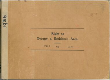
Administrative record - Right to Occupy Certificates
Ten books containing stubs of Right to Occupy Certificates for 1936. Includes name and address of person receiving the Right to Occupy certificate and the description of the land including allotment, Section, City, Town, Borough or Township and Parish name. Two blue covered books used for Substitute Right to occupy certificates. One book, stubs only, dated 1976 - 1981. One with four stubs dated 1981 - 1983. Four stapled bundles of stubs dated 1937 - 1971 issued for Replacement Rights. Includes names and Receipt numbers. Yellow foolscap sheet Listing reord numbers of Rights issued during 1936 and 1937.Some items have pencil and pen marks and ink stains.right to occupy, central victoria -
 Kew Historical Society Inc
Plan - Subdivision Plan, Mayfield Estate, 1927
A number of the plans in the Kew Historical Society’s collection can also be found in other collections, such as those of the State Library of Victoria. A number are however unique to the collection.The Kew Historical Society collection includes almost 100 subdivision plans pertaining to suburbs of the City of Melbourne. Most of these are of Kew, Kew East or Studley Park, although a smaller number are plans of Camberwell, Deepdene, Balwyn and Hawthorn. It is believed that the majority of the plans were gifted to the Society by persons connected with the real estate firm - J. R. Mathers and McMillan, 136 Cotham Road, Kew. The Plans in the collection are rarely in pristine form, being working plans on which the agent would write notes and record lots sold and the prices of these. The subdivision plans are historically significant examples of the growth of urban Melbourne from the beginning of the 20th Century up until the 1980s. A number of the plans are double-sided and often include a photograph on the reverse. A number of the latter are by noted photographers such as J.E. Barnes.The Mayfield Estate subdivision included 14 allotments surrounding Evan Court (now Evans Court) in Toorak. The subdivision adjoined Toorak Road east of Kooyong Road and alerted prospective buyers to how the Toorak Road tram would take them directly to the city. This emphasis on existing transport routes was a feature of subdivisions during a period when car ownership was the preserve of the wealthy. An existing brick villa (‘Mayfield’) is noted as already constructed on lot 13. The subdivision also notes that the lots adjoin land owned by Sir Edward Miller. Today Evans Court extends beyond this subdivision through to Moonga Road.subdivision plans - toorak, mayfield estate, sir edward miller -
 Kew Historical Society Inc
Map, MMBW, MMBW Plan No.117 Heidelberg & Kew, 1900-1910
The Melbourne and Metropolitan Board of Works (MMBW) was established by an act of the Victorian Parliament in 1890 to prepare for and to implement a sewerage and water reticulation system across what was then inner Melbourne, its surrounding and middle distance suburbs, including Kew. The MMBW was disbanded in 1991.The map collection of the Kew Historical Society has at its core the historic maps assembled and originally stored in the City Engineer's Department of the City of Kew. These include maps in a number of scales. The vast majority of maps were produced by the MMBW in the first two decades of the twentieth century, and are solid working maps, backed by linen for durability. These maps are historically significant to Kew, the City of Boroondara and to the history of the development of state utilities in Victoria. A number of the Kew maps have additional details added by former municipal officers, including the levels reached by various floods. As these were working documents, information was added to them long after the period of their initial production and distribution.Early map of part of the Borough of Kew, created in the early twentieth century, at a scale 160 ft to 1 inch. The map covers what was then the north eastern part of Kew showing the natural landscape and limited development on the south side of the Yarra River. In the Kew section, south of the river, the land is occupied currently by the Greenacres and Kew Golf Clubs. The map shows the extent of urban development by that time and the outlines of the few built structures in the municipality. The height above sea level of all parts of the landscape are indicated numerically in feet. Contour lines and the levels of historic floods were added in ink to the map at a later stage. MELBOURNE AND METROPOLITAN BOARD OF WORKS / PLAN NO. 117 / HEIDELBERG & KEW melbourne & metropolitan board of works, mmbw maps, borough of kew, cartography, mmbw plan no. 117, kew (vic.) -- maps, heidelberg (vic.) -- maps -
Kew Historical Society Inc
Archive (Sub-series) - Subject File, Latrobe Golf Club
Kew Historical SocietySince its foundation in 1958, members of the Kew Historical Society have been compiling and storing information about subjects relating to the history of Kew and its environs, of which this file is an example. Arranged by Secondary Values (value of records to users)Subject file containing information about the Latrobe Golf Club and course. The file contains a copy of a 1959 newspaper account of the building of the clubhouse on part of the former Lucern Farm which Thomas Wills established 120 years previously. The farm was later owned by Perce Lay, a Gallipoli veteran who progressively sold off parts until only 24 aces of the original 176 acres was left. The file also has a typescript of the back of Lucern Farm sale brochure for the auction on 14/4/1956. suggesting possible uses. Also gives an account of Thomas Wills' life and the improvements he made to the land. thomas wills, lucern farm, perce lay, latrobe golf coursethomas wills, lucern farm, perce lay, latrobe golf course -
 Surrey Hills Historical Society Collection
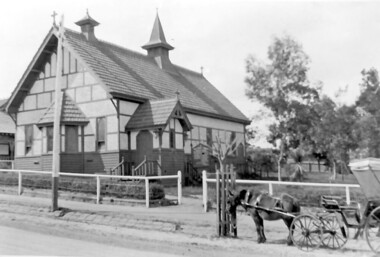
Photograph, Holy Trinity Church, Surrey Hills in the 1920s
This church was built in 1907 and became known as Holy Trinity Surrey Hills. This name had previously been used by the Anglican Church in Mont Albert Road, Mont Albert. This henceforth became known as St George's Anglican Church, Mont Albert. There are 2 copies: the original donated print and an enlargement. The original is mounted on card with photo mounts along with 890, 891 and 892. It measures 13 cm x 9 cm. Norman Carter took many photos of Surrey Hills and Mont Albert from the 1920s in particular of events and activities associated with the Church of England.Black and white photo of the original Holy Trinity Church building in Union Road. It is constructed of weatherboards, above which there is plasterboard and timber strapping. The roof is of terracotta tiles with a small steeple at the front and a larger one towards the rear of the building. There is a box bay window at the front and the entrance is from a porch on the southern side of the building. This is approached by stairs. Part of the vicarage can be seen on the northern high side of the church and to the south there is vacant land. The whole property sits behind a simple post and wire fence. There is a phaeton in the foreground beside a relatively newly planted street tree. The road has bluestone kerb and channelling.churches, holy trinity church, anglican church, horse-drawn vehicles, norman brodley carter, union road -
 Melbourne Tram Museum
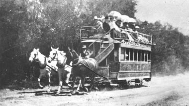
Photograph - Black & White Photograph/s, c1900
Black and white photograph of an illustration of the Beaumaris Horse Tram. The photo shows the tram being pulled by 3 horses with several passengers on the top level. The Beaumaris Tramway Company commenced operations in 1887 between Sandringham and Cheltenham railway stations, and managed to survive until 1914. The tramway was operated by Charles Henry James in an attempt to sell land developed by him at Black Rock, Sandringham and Mentone. Stamped on the back "...The Argus...negative No P2225" See also Reg Item 5014 for another photograph of a horse tram. 2nd copy from Keith Kings added 6/8/2020 - see images i2 and i3.trams, tramways, argus, beaumaris horse tram, horse trams -
 Bendigo Historical Society Inc.
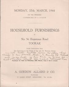
Document - AUCTION CATALOGUE - 36 HOPETOUN ROAD, TOORAK, 1944
Booklet. 12 page auction catalogue for household furnishings at 36 Hopetoun Rd. Toorak, Victoria. Auction of 287 items held on 27 March 1944 under instructions from the executors of the late Dr. Ramsay Mailer. Auctioneers were A. Gordon Allard & Co. of 37 Queen St, Melbourne. Printed by Stock land Press. Handwritten in ink on the front page is the following, by author unknown - 'My late sister Matron Agnes Wilson had charge of his private Hosp. in Burke Rd. Camberwell and years later of his Hosp in Wood St. East Preston which she named 'Pleasant View' '.A. Gordon Allard & Co.person, individual, auction, auction, household furnishings, 36 hopetoun rd., toorak, dr. ramsay mailer, agnes wilson, a. gordon allard -
 Eltham District Historical Society Inc
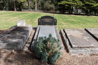
Photograph, Peter Pidgeon, Grave of Guido Quarto Fabbro, Eltham Cemetery, Victoria, 5 April 2021
Guido Quarto Fabbro was born 21 August 1891 at Treppo Grande in the far northeast of Italy, the son of Giacomo Fabbro and Anna Geruzzi. Regina Moretti was born 6 March 1893 at Treppo Grande, Italy, the daughter of Giovanni Battista Moretti and Maria Teresa Coletti. Guido and Regina married about 1917 and they had two sons, Giacomo (John c.1918) and Maurie (c.1920). In 1925 Guido Fabbro departed his homeland from Genoa, arriving in Fremantle, Western Australia in June, travelling 3rd class aboard the ship, Caprera. Regina and their two boys followed a year later along with other family members arriving in Fremantle from Genoa 4 July 1926 aboard the Moncalieri. The Fabbro arrived in Eltham in 1933 and purchased a block of land from William West on the western side of Falkiner Street, extending to Ely and Porter Streets which had formerly been part of the West family orchard and dairy farm. As there was no fencing dividing the two properties, West served notice on Guido in December 1934 to bear half of the cost of £6. When payment was not forthcoming, West sued Guido in the Eltham Court in January 1935. Guido failed to appear and was not represented, and costs were ordered in West’s favour. Guido and Regina built a large Italianesque house on their property. The original 1860s cottage was relocated to the back of the block and was rented out (once to Alistair and Margot Knox). Guido also purchased land extending to the Diamond Creek on the eastern side of Falkiner Street and on the eastern side of Bell Street (opposite Eltham High School). The riparian soil was suitable for market gardening: Guido grew mainly tomatoes, but also pumpkins, cauliflowers, cabbages, peas, beans, lettuce, beetroot and zucchinis. Even the land surrounding the house was used. The produce was carted to Melbourne overnight for sale at the market. Guido died in 1970 and is buried in Eltham cemetery. Regina died 1986. She and their son John Patrick (Giacomo) Fabbro who died in 1984 are also buried at Eltham Cemetery. Guido’s son Maurie continued in his father’s footsteps until 2007, principally growing artichokes in later years. He died in 2009. The land on the eastern side of Falkiner Street now forms part of a Council reserve called “Barak Bushland”, the land on the western side having been sold off for residential subdivision. The Bell Street land is now public open space managed by Nillumbik Shire Council and called “Fabbro Fields”. There have been recent proposals to develop the site for sporting purposes or as a dog park or community garden. In Memory of Guido Quarto Fabbro Beloved husband of Regina Died 15-3-1970 aged 79 R.I.PBorn Digitaleltham cemetery, gravestones, guido quarto fabbro, regina fabbro -
 Eltham District Historical Society Inc
Photograph, Hans Gregory, Original 1860s William West house, Fabbro's Farm, Falkiner Street, Eltham, c.1990
Photos taken by Hans Gregory who along with partner Pauline Steele, rented the original old 1860s William West Cottage situated behind the Fabbro family home. Hans was employed as a Youth officer with the Shire of Eltham at the time and was the last tennant on the property. The property was sold and in 1995 was developed for residential housing as the Riverview Park estate. Guido Quarto Fabbro was born 21 August 1891 at Treppo Grande in the far northeast of Italy, the son of Giacomo Fabbro and Anna Geruzzi. Regina Moretti was born 6 March 1893 at Treppo Grande, Italy, the daughter of Giovanni Battista Moretti and Maria Teresa Coletti. Guido and Regina married about 1917 and they had two sons, Giacomo (John c.1918) and Maurie (c.1920). In 1925 Guido Fabbro departed his homeland from Genoa, arriving in Fremantle, Western Australia in June, travelling 3rd class aboard the ship, Caprera. Regina and their two boys followed a year later along with other family members arriving in Fremantle from Genoa 4 July 1926 aboard the Moncalieri. The Fabbros arrived in Eltham in 1933 and purchased a block of land from William West on the western side of Falkiner Street, extending to Ely and Porter Streets which had formerly been part of the West family orchard and dairy farm. As there was no fencing dividing the two properties, West served notice on Guido in December 1934 to bear half of the cost of £6. When payment was not forthcoming, West sued Guido in the Eltham Court in January 1935. Guido failed to appear and was not represented, and costs were ordered in West’s favour. Guido and Regina built a large Italianesque house on their property. The original 1860s cottage was relocated to the back of the block and was rented out (once to Alistair and Margot Knox). Guido also purchased land extending to the Diamond Creek on the eastern side of Falkiner Street and on the eastern side of Bell Street (opposite Eltham High School). The riparian soil was suitable for market gardening: Guido grew mainly tomatoes, but also pumpkins, cauliflowers, cabbages, peas, beans, lettuce, beetroot and zucchinis. Even the land surrounding the house was used. The produce was carted to Melbourne overnight for sale at the market. Guido died in 1970 and is buried in Eltham cemetery. Regina died 1986. She and their son John Patrick (Giacomo) Fabbro who died in 1984 are also buried at Eltham Cemetery. Guido’s son Maurie continued in his father’s footsteps until 2007, principally growing artichokes in later years. He died in 2009. The land on the eastern side of Falkiner Street now forms part of a Council reserve called “Barak Bushland”, the land on the western side having been sold off for residential subdivision. The Bell Street land is now public open space managed by Nillumbik Shire Council and called “Fabbro Fields”. There have been recent proposals to develop the site for sporting purposes or as a dog park or community garden. Provides an insight into early settler's farmhouses and farming property of the Eltham district.guido quarto fabbro, regina fabbro (nee moretti), william west, maurie fabbro, fabbro's farm, hans gregory, west family orchard, west dairy farm -
 Eltham District Historical Society Inc
Photograph, Hans Gregory, Original 1860s William West house, Fabbro's Farm, Falkiner Street, Eltham, c.1990
Photos taken by Hans Gregory who along with partner Pauline Steele, rented the original old 1860s William West Cottage situated behind the Fabbro family home. Hans was employed as a Youth officer with the Shire of Eltham at the time and was the last tennant on the property. The property was sold and in 1995 was developed for residential housing as the Riverview Park estate. Guido Quarto Fabbro was born 21 August 1891 at Treppo Grande in the far northeast of Italy, the son of Giacomo Fabbro and Anna Geruzzi. Regina Moretti was born 6 March 1893 at Treppo Grande, Italy, the daughter of Giovanni Battista Moretti and Maria Teresa Coletti. Guido and Regina married about 1917 and they had two sons, Giacomo (John c.1918) and Maurie (c.1920). In 1925 Guido Fabbro departed his homeland from Genoa, arriving in Fremantle, Western Australia in June, travelling 3rd class aboard the ship, Caprera. Regina and their two boys followed a year later along with other family members arriving in Fremantle from Genoa 4 July 1926 aboard the Moncalieri. The Fabbros arrived in Eltham in 1933 and purchased a block of land from William West on the western side of Falkiner Street, extending to Ely and Porter Streets which had formerly been part of the West family orchard and dairy farm. As there was no fencing dividing the two properties, West served notice on Guido in December 1934 to bear half of the cost of £6. When payment was not forthcoming, West sued Guido in the Eltham Court in January 1935. Guido failed to appear and was not represented, and costs were ordered in West’s favour. Guido and Regina built a large Italianesque house on their property. The original 1860s cottage was relocated to the back of the block and was rented out (once to Alistair and Margot Knox). Guido also purchased land extending to the Diamond Creek on the eastern side of Falkiner Street and on the eastern side of Bell Street (opposite Eltham High School). The riparian soil was suitable for market gardening: Guido grew mainly tomatoes, but also pumpkins, cauliflowers, cabbages, peas, beans, lettuce, beetroot and zucchinis. Even the land surrounding the house was used. The produce was carted to Melbourne overnight for sale at the market. Guido died in 1970 and is buried in Eltham cemetery. Regina died 1986. She and their son John Patrick (Giacomo) Fabbro who died in 1984 are also buried at Eltham Cemetery. Guido’s son Maurie continued in his father’s footsteps until 2007, principally growing artichokes in later years. He died in 2009. The land on the eastern side of Falkiner Street now forms part of a Council reserve called “Barak Bushland”, the land on the western side having been sold off for residential subdivision. The Bell Street land is now public open space managed by Nillumbik Shire Council and called “Fabbro Fields”. There have been recent proposals to develop the site for sporting purposes or as a dog park or community garden. Provides an insight into early settler's farmhouses and farming property of the Eltham district.guido quarto fabbro, regina fabbro (nee moretti), william west, maurie fabbro, fabbro's farm, hans gregory, west family orchard, west dairy farm