Showing 16085 items
matching area
-
 Eltham District Historical Society Inc
Photograph, Gayle Blackwood, Tower at back of mudbrick house, possibly St Andrews area
Colour print 10 x 15 cmmudbrick, st andrews, houses, gayle blackwood collection -
 Eltham District Historical Society Inc
Photograph, Para Road, Montmorency, industrial area looking south from Plenty River Bridge on boundary of Shire of Eltham
Colour photograph02076, montmorency (france) photo album, montmorency, para road, plenty river, industry -
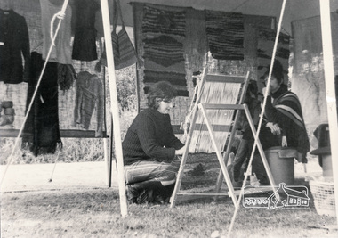 Eltham District Historical Society Inc
Photograph, Eltham Living and Learning Centre Open Day, tent in front of car park area, circa 1986, 1986c
Eltham Living and Learning Centre activities Black and white photographclasses, eltham living and learning centre -
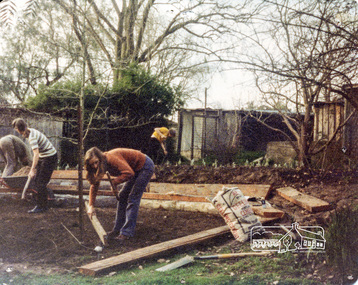 Eltham District Historical Society Inc
Photograph, Putting in the seating for the theatre area, Eltham Living and Learning Centre, c.Sept. 1976, 1970s
Colour photographeltham living and learning centre -
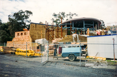 Eltham District Historical Society Inc
Photograph, Cr. Peter Graham, Steel posts in the library foyer entrance and display area, Eltham Library construction, Oct 1993, 1993
Construction of the new Eltham Library 1993-1994. Officially opened 22 May 1994. Formerly mounted on display card 40 x 50 cm (9 images)Colour photographconstruction, eltham library -
 Kiewa Valley Historical Society
Folder - Local Area Study of Mt Beauty, Local Area Study of Mt Beauty by a student, David, with acknowledgement to Alex McCullough & Mr C. De-Goi
The History of Mt Beauty is about the unique development of a construction town built in the 1940s by the State Electricity Commission of Victoria during the construction of the Kiewa Hydro Electric Scheme. This history gives an insight into a student's understanding and areas of interest in the development of Mt Beauty.Black plastic cover with three fasteners holding 188 pages with black print, photos and diagrams.'Ticks' have been added by the teacher on many of the pages. On the back of the last page: Teacher's comments and mark 195/200.history of mt beauty, secv, khes, alex mccullough -
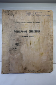 Kiewa Valley Historical Society
Book - Telephone Directory of the Kiewa Area, State Electricity Commission of Victoria -Telephone Directory - Kiewa Area
The State Electricity Commission produced a Telephone directory for each of its construction sites during the construction of the Kiewa Hydro Electric Scheme during the 1950s to early 1960s. The telephones were linked via the Switchboard. The booklet includes instructions for operating.The SECV constructed the KHES during the 1950s. It included construction sites on the Bogong High Plains and the townships of Bogong and Mt Beauty. It also connected the Scheme with the outside world and was operated through the switchboard which was located in Mt Beauty. This booklet also gives names of staff and some workmen - their occupation and their whereabouts of work at the time. Cardboard cover with pages inside bound by metal clasp. Pages divided with tabbed headings:- Bogong, Mt Beauty, West Kiewa, McKay Creek Howmans, Rocky Valley Langford's Gaptelephone directory kiewa hydro electric scheme, kiewa hydro electric scheme telephones -
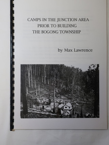 Kiewa Valley Historical Society
Booklet - Camps at Bogong Junction. 1930s, Camps in the Junction Area Prior to Building the Bogong Township by Max Lawrence
During the construction of the Kiewa Hydro Electric Scheme at Bogong Junction camps of tents were built from 1935. These were replaced by houses for the workers in 1940 when the Bogong township was built.The SECV constructed the Bogong township to house workers on the Kiewa Hydro Electric SchemeA plastic Folder with a black spiral spine and black back cover. 3 pages typed on one side naming and describing the camps at Bogong Junction in the 1930s.miners camp, staff camp, reservoir camp, bogong township, lewis construction camp, albion quarry camp -
 Eltham District Historical Society Inc
Photograph, Aerial view of Yarra River near Kangaroo Ground - Bend of Islands area
Sepia aerial view of Yarra river at Bend of Islands; Henley Road on left in foregroundbend of isles, kangaroo ground, yarra river, henley road -
Eltham District Historical Society Inc
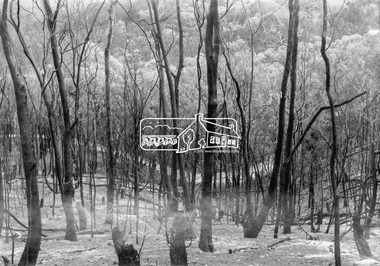
Photograph, George W. Bell, Fire Laughing Waters Area, 1965
Black and white photograph of fire aftermath Laughing Waters Road Eltham 1965laughing waters road, eltham, fires, bush fires, george w bell collection -
Eltham District Historical Society Inc
Photograph, George W. Bell, Laughing Waters Area, 1965
Black and white photograph of D. Armfield and R. Melville view fire aftermath Laughing Waters Road Eltham 1965laughing waters road, eltham, fires, bush fires, david armfield, rod melville, george w bell collection -
 Eltham District Historical Society Inc
Photograph, George W. Bell, Eltham, Laughing Waters Area, 1965
Black and white photograph of fire aftermath Laughing Waters Road Eltham 1965laughing waters road, eltham, fires, bush fires, george w bell collection -
Eltham District Historical Society Inc
Photograph, George W. Bell, Eltham Laughing Waters Area, 1965
Black and white photograph of bushfire aftermath Laughing Waters Road Eltham 1965laughing waters road, eltham, fires, bush fires, george w bell collection -
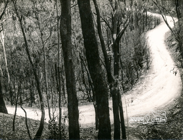 Eltham District Historical Society Inc
Photograph, George W. Bell, Fire Aftermath, Laughing Waters Area, 1965
Black and white photograph of bushfire aftermath Laughing Waters Road Eltham 1965.laughing waters road, eltham, fires, bush fires, george w bell collection -
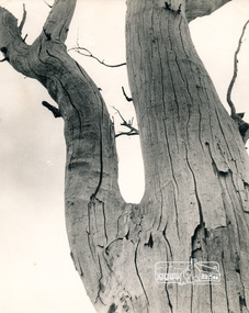 Eltham District Historical Society Inc
Photograph - Black and White Print, George W. Bell, Dead Red Gum, Eltham Templestowe Area
Black and white print on photo paper 35mm Black and white slide copy Mount - white 7 dots (Technodia Italy)george w bell collection, significant tree -
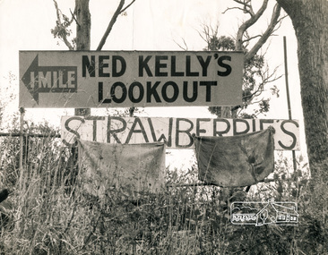 Eltham District Historical Society Inc
Photograph, George W. Bell, Kinglake Area
Black and white photograph of signs Ned Kelly's Lookout and Strawberries near Gangelhoff Road Kinglakekinglake, ned kellys lookout, signs, gangelhoff road, george w bell collection -
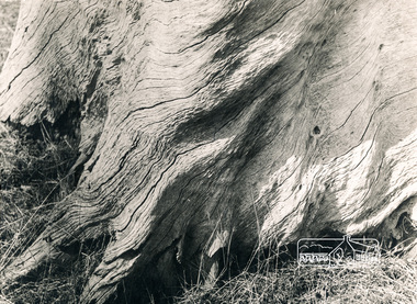 Eltham District Historical Society Inc
Photograph, George W. Bell, Red Gum, Eltham-Templestowe area
Black and white photograph of dead redgum treetrunk near Fitzsimons Lane Elthamtrees, eltham, fitzsimons lane, george w bell collection -
 Eltham District Historical Society Inc
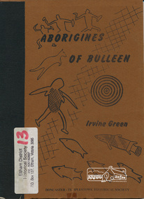
Book, Irvine Green, Aborigines of Bulleen : the history of the Aborigines of the Wurundjeri tribe who inhabited the area which became the city of Doncaster and Templestowe / Irvine Green, 1989
Wurundjeri territorial groupings; subsistence; recreation of daily life; recreation; tribal law; kinship; childhood; religion and mythology; material culture, includes description of bark canoe manufacture; map of significant sites; culture contact and historyPaperback; 40 p. : ill., maps ; 23 cm.ISBN 0947353003aborigines, wurundjeri, social customs, stories, bulleen -
 Eltham District Historical Society Inc
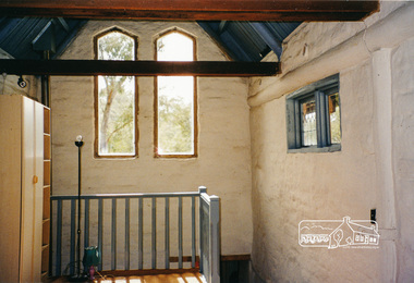
Photograph, Gayle Blackwood, Alistair Knox designed mudbrick home, rural area Nillumbik
Nine colour prints 10 x 15 cm Cross Ref: 00648 (print) and 03183 (negative)houses, mudbrick, gayle blackwood collection -
 Eltham District Historical Society Inc
Photograph, Peter and Carla Vermey in family area, studs still exposed
14 Stokes Place (Lot 83) was the home of Peter and Carla Vermey. The land was purchased in May 1979 and construction commenced September 1979. The home was built by Peter and Carla Vermey after the developer, Macquarie Builders went bankrupt. Sold October 2017 by Morrison and Kleeman Real Estate. Stokes Place was part of the Stokes Orchard Estate which was developed from the break-up of the the orchard owned by Frank Stokes who lived on the northeast corner of Nyora Road and Eucalyptus Road. His daughter Beryl advised that the Shire had levied a rate assessment on individual parcels of land within the orchard which became unaffordable resulting in its sub-division and sell off. The Stokes Orchard Estate was developed by Macquarie Builders in two stages starting with stage 1 in 1976. Stokes Place was part of Stage 2 in 1979. The Estate was bounded between Nyora Road, Eucalyptus Road, Diosma Road and Stokes Place. The original orchard only just reached the left most portions of Stokes Place and did not go fully up to Diosma, rather to just beyond the extant of Stokes Place. Stokes Place was known within the family as "The Oats" as that is where they grew oats. Frank Stokes moved to Eltham c.1945 after visiting Harold Bird to view his orchard, located diagonally opposite Stokes Orchard from the intersection of Eucalyptus Road, Pitt Street and Nyora Road. It was on Harold Bird's recommendation that Frank purchased the land.The Stokes Orchard Estate collection is typical of housing developments of the late 1970s and 1980s. It was one of the earliest estates in Eltham following the nearby Woodridge Estate development.Digital fileScanned by EDHS from 49 x 35mm colour transparencies provided on loanstokes place, eltham, stokes orchard, stokes orchard estate, streets, houses, peter and carla vermey -
 Eltham District Historical Society Inc
Negative - Photograph, Eltham - Laughing Waters area, 1965
Source: Geo. W. Bell, Eltham See "History of Bushfires in Nillumbik" page 43.This photo forms part of a collection of photographs gathered by the Shire of Eltham for their centenary project book,"Pioneers and Painters: 100 years of the Shire of Eltham" by Alan Marshall (1971). The collection of over 500 images is held in partnership between Eltham District Historical Society and Yarra Plenty Regional Library (Eltham Library) and is now formally known as the 'The Shire of Eltham Pioneers Photograph Collection.' It is significant in being the first community sourced collection representing the places and people of the Shire's first one hundred years.Digital image 4 x 5 inch B&W Negsepp, shire of eltham pioneers photograph collection, eltham, bushfire, laughing waters -
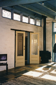
 Eltham District Historical Society Inc
Photograph, Gayle Blackwood, Alistair Knox designed mudbrick home, rural area Nillumbik
Designed by Alistair KnoxRoll of 35mm colour negative film, 10 strips Kodak Gold 100-6 Cross Ref: 00648 (print) and 03183 (negative)gayle blackwood collection, houses, mudbrick, alistair knox -
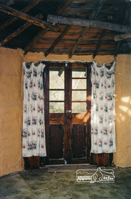
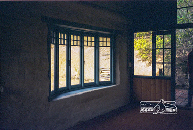
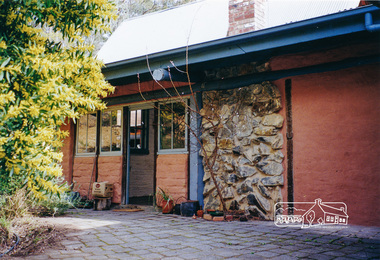
 Eltham District Historical Society Inc
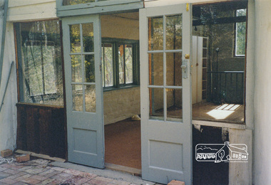
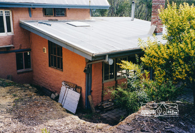
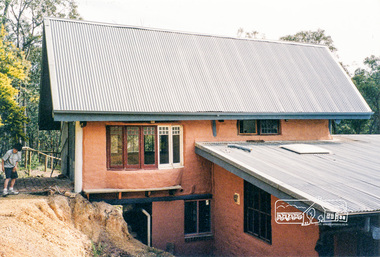
Photograph, Gayle Blackwood, Mudbrick house, possibly St Andrews area, c. Feb 2002, 2002
Colour print 10 x 15 cm Cross Ref: 02061 (print) and 03183 (negative)mudbrick, st andrews, houses -
 Eltham District Historical Society Inc
Photograph, Gayle Blackwood, Mudbrick house, possibly St Andrews area, c. Feb 2002, 2002
Colour print 10 x 15 cmmudbrick, st andrews, houses -
 Eltham District Historical Society Inc
Photograph, Gayle Blackwood, Mudbrick house, possibly St Andrews area, c. Feb 2002, 2002
Colour print 10 x 15 cmmudbrick, st andrews, houses -
 Eltham District Historical Society Inc
Photograph, Gayle Blackwood, Mudbrick house, possibly St Andrews area, c. Feb 2002, 2002
Colour print 10 x 15 cmmudbrick, st andrews, houses -
 Eltham District Historical Society Inc
Photograph, Gayle Blackwood, Mudbrick house, possibly St Andrews area, c. Feb 2002, 2002
Colour print 10 x 15 cmmudbrick, st andrews, houses -
 Eltham District Historical Society Inc
Photograph, Gayle Blackwood, Mudbrick house, possibly St Andrews area, c. Feb 2002, 2002
Colour print 10 x 15 cmmudbrick, st andrews, houses -
 Eltham District Historical Society Inc
Photograph, Gayle Blackwood, Mudbrick house, possibly St Andrews area, c. Feb 2002, 2002
Colour print 10 x 15 cmmudbrick, st andrews, houses -
 Eltham District Historical Society Inc
Photograph, Gayle Blackwood, Mudbrick house, possibly St Andrews area, c. Feb 2002, 2002
Colour print 10 x 15 cmmudbrick, st andrews, houses